Tag Archives: Chinook Salmon

Mullet Creek’s Secret Waterfalls

Monday October 12, 2015

Mullet Creek contained a couple of surprise waterfalls and an old dam in the short section we hiked.  It originates in Meadowvale north of the 407  and empties into the Credit River on the University of Toronto Mississauga campus.  It was a gorgeous long weekend and Thanksgiving Monday was a beautiful day for a brief hike before getting the turkey in the oven.  We parked on O’Neil Court and entered the woods through the community walkway.

Reginald Watkins bought 150 acres of land in 1928 north of the now abandoned Erindale Power Dam.  He tore down one house on the property and enlarged the other which was named Lislehurst.  In 1965 The University of Toronto bought the property and founded Erindale College which is now called University of Toronto Mississauga.  The section of park backs onto the university campus and contains the remains of an old out building at the crest of the hill overlooking the ravine.  It appears that a series of trial excavation holes have been dug to investigate the ruins.

IMG_0664

A long thin promontory of land provides access to the creek level.  We followed it down to where Mullet Creek winds it’s way through the ravine and on to the Credit River nearby. The creek splits into sections in the ravine and we crossed each in turn as we made our way north along the valley floor.

IMG_0667

There are over 30 varieties of periwinkle.  As an invasive species they grow aggressively, often choking out native plant life.  They are frequently recommended for partially shaded areas or places where growing plants is difficult.  Care must be taken because they can escape and take hold in the wild.  One plant can spread to an area 8 feet across.  They normally bloom in late April to early May but we found a stray splash of periwinkle blue in the undergrowth.

IMG_0670

An old steam boiler lies rusting away at the side of Mullet Creek.  It would have originally stood on four metal feet on the bottom.  The lower half contained the fire box and was open on the opposite side to this picture.  The front flue sheet contains the holes that the flues passed through and is matched by a second flue sheet on the back.

IMG_0679

Mullet Creek is crossed by the double span of Burnhamthorpe Road.  A recent assessment was done for this bridge as well as sister bridges over the Credit River just east of here.  Original construction had created bridges where the sidewalks were too small to be properly functional. The study was completed to address several concerns.  At just .838 metres high, the guard rail on the river edge of the sidewalk was considered too low for safety.  The proposal was to increase this rail to 1.4 m.  There was also no rail between the sidewalk and road and so a second rail was proposed on the curb side.  The sidewalk was to be increased from 1.7 to 3 metres wide to allow cyclists and pedestrians to safely pass.  Look-out platforms were also created. This was accomplished by widening the road deck on the outside of the bridge.  The west bound span is seen from the creek level in the picture below.

IMG_0693

Just beyond the Burnhamthorpe bridge lie the remains of an old dam.  Original wooden sections remain submerged in the water behind later concrete forms while the pre-cast concrete blocks on the top were added later still.

IMG_0699

Prior to the arrival of Europeans, Atlantic Salmon were common in Lake Ontario and spawned in the Credit River every fall.  Due to pollution, dams, over-fishing and deforestation they were basically eliminated by the 1890’s.  In the 1960’s and 1970’s Chinook and Coho Salmon were introduced from the Pacific coast.  Chinook Solmon make their only spawning run when they are 4 years old and then die afterward.  This male Chinook has developed the characteristic hooked jaw called a kype and the darker colour of his one and only run upstream.  They can usually grow to lengths of 3 feet and weights of 25 pounds.  This specimen was caught by a young fellow named Jack who was fishing with his family.

IMG_0702

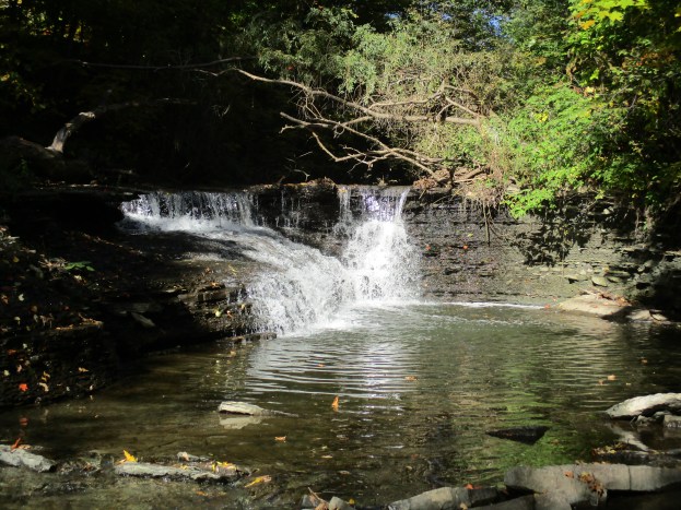
As you walk up Mullet Creek toward Mississauga Road you come to several shelves of shale where the water cascades over the edge.  The picture below was taken just one bend in the creek prior to the cover photo which has a larger drop.  These two little water falls make an oasis in the heart of the city.

IMG_0707

At one time a parkette stood at the corner of the creek and Mississauga Road.  The remains of the old parking area are starting to grow over but the old rail ties that outline the side and protect the trees in the middle will be around for many years to come.

IMG_0717

Mullet Creek extends from here to north of the 407 and must contain other interesting places. Time will tell.

Like us at http://www.facebook.com/hikingthegta
Erindale Hydro Electric Dam

Sunday Oct. 19, 2014

Sunday morning was cold at only 2 degrees.  To access the parking lot at Erindale park you have to drive through a break in the wall of the old Erindale Dam.

In 1902 Erindale Light and Power Company was formed to construct an hydro electric generating plant on the Credit River at Erindale.  This large scale engineering project ran into several delays during construction and didn’t begin producing power until 1910.  A dam was constructed across the valley flooding it and creating the 125 acre Lake Erindale.  A power generating plant was built on the south end of town at the bottom of Proudfoot Street.  A tunnel was constructed to connect the two.  The power plant operated from 1910 until 1923 supplying power to Erindale and New Toronto. It was closed when Ontario Hydro began to supply the area with power from Niagara Falls.  In 1941 the lake was drained and the dam was blown up.  Between 1961 and 1965 the former lake bottom was used as a sanitary landfill.  It has since been covered over with clean soil and Erindale Park has been created.

From the top of the old dam the view across the old lake bed gives you a good impression of the size of dam and the lake it created.

IMG_0683

Walking north along the east side of the river we came to this shopping cart which has obviously been standing in the river when the water was much higher.  The shiny coffee mug on top belongs to a clever angler who is fishing near by.

IMG_0694

As you head upstream from the old dam there is a foot bridge that will allow you to cross over the river to explore the ruins of the dam on the other side.  This photo shows one of three old water control structures that are in the river above the dam.  There are six fishermen in this picture (how many can you see?) and the shopping cart.

IMG_0698

When settlers first arrived the rivers around Toronto were filled with Atlantic Salmon.  Pollution, deforestation and the construction of dams resulted in their extermination within only a few decades.  In the 1960’s and 1970’s large numbers of Chinook salmon were stocked in the rivers. The eggs hatch in May from the gravel beds where they winter and and the fingerlings make their way out into lake Ontario.  They will die if they stay in the river until the water warms up. They spend four to eight years in the lake attaining a size of up to 40 pounds before they make their only spawning run.  Then they will migrate from the lake into the same river in which they were born.  It is estimated that 20,000 Chinook make the trip up the Credit River each fall.  After spawning they die and their carcasses litter the river providing easy pickings for the local birds. The fish in the picture below was a recent catch from one of the people fishing in the river.  It looked to be about 25 to 30 pounds.

IMG_0699

The expression “busy as a bee” applies to this little creature.  Although the weather was too cold for most bees a few industrious ones were busy collecting pollen from late blooming Canada Thistles. This purple flower is coated with white pollen.  The bee is collecting it and storing it in the hair all over it’s body.  Bumble bees can’t fly unless their wing muscles are at least 30 degrees C.  On cold days such as this they beat their wings at the rate of 130 times a minute to raise their body temperature enough to take off.

IMG_0730

The Bulrush or Cat-o-Nine tails grows in wetland areas.  There is a stand of them growing close to the base of the old dam.  Various parts of the plant can be eaten and were part of the native people’s diet.  This makes them valuable as an emergency source of food in a survival situation. Peeled stems or leaf bases can be eaten raw.  The roots need to be cooked and peeled but they also are edible.  The roots can also be used as a poultice for burns and wounds.  Care must be taken not to eat bulrushes that grow in polluted water as they are a bio-mediator which absorbs pollution.  Signs of contamination include a bitter or spicy taste.

IMG_0702

At the foot of the dam on the west side of the river is a small mill race where the water is standing still.  The leaves floating on the water lend a sense of calm to the scene.  In the middle of the picture is a tire that appears to be standing on top of the water.  A close look at an enlarged photo shows the green neck of a male mallard duck which is having a bath just to the right of the tire.

IMG_0742

St. Peter’s Anglican church stands on the hill top on the corner of Mississauga Road and Dundas Street.  The first building was opened in 1825.  It was replaced with this stone building in 1887. Roy Ivor, who ran the Winding Lane Bird Sanctuary across the street, is buried here.

IMG_0745

The north entrance to the water tunnel is located in the woods at the end of the last parking lot. This stood at the edge of Lake Erindale and a pair of sluice gates was used to control the water flow into the tunnel at the bottom.  This structure is decayed badlly and has a small forest growing in the open area inside the mouth.

IMG_0752

This photo was taken by holding the camera inside of the tunnel as it heads under Dundas street.  This is in effect the head race for the power mill.

IMG_0756

The tunnel passes under Dundas Street just east of Proudfoot Street.  It then emerges just past the end of Proudfoot Street where the river doubles back on the edge of town.  The power generating plant stood here until it was removed in 1977.  The picture below shows the power station and the tail race where the water was returned to the river.

LG_K370