Monthly Archives: June 2021

The Whitney Block – Toronto’s Empty Tower

June 27, 2021

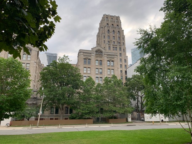
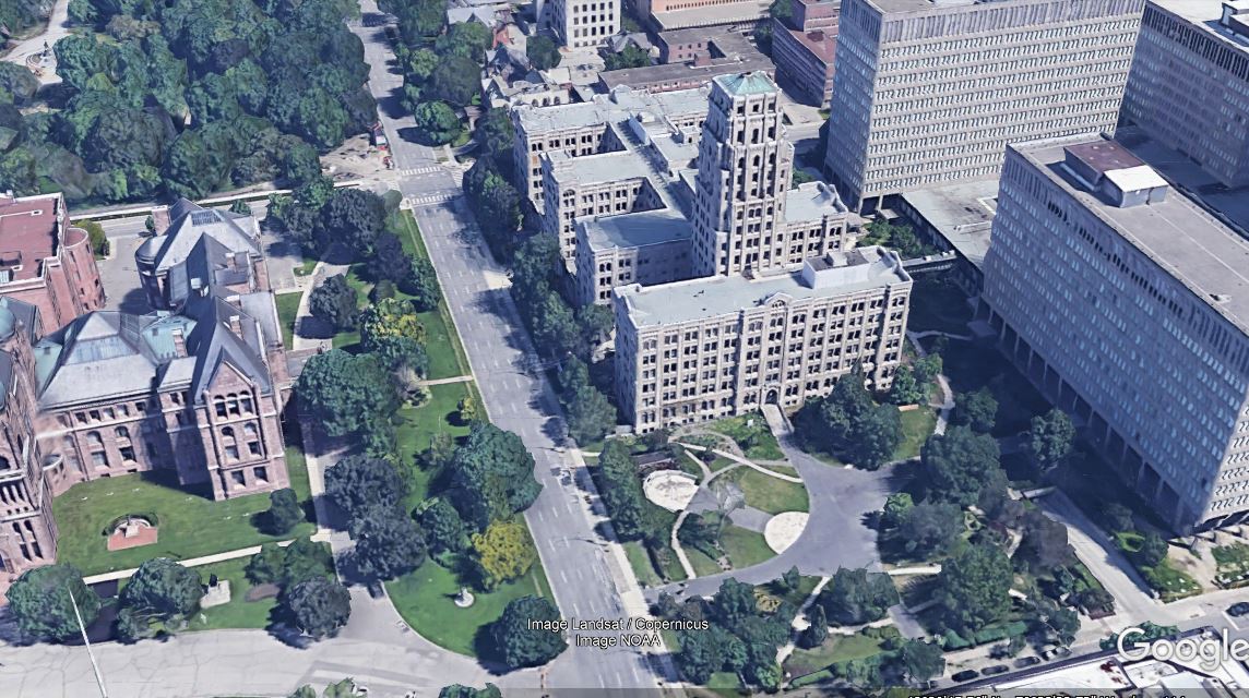
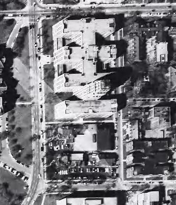
In Toronto, almost any building that has been vacant since last Thursday has a sign on it for redevelopment as a condo project. So how is it that we have one right downtown that was last used in 1968? Its roots lie in the Ontario Legislature building at Queens Park which was completed in 1892 when the province had a population of just over 2.1 million people. Over the next two decades the population grew by 40 percent and the government quickly outgrew a couple of expansions. Rather than adding a couple of more floors to Queens Park it was decided in 1923 to purchase the land on the east side of Queens Park Crescent. Francis R. Heakes was the Chief Architect for Public Works Ontario and was given the task of designing the new office space that would occupy the site. Envisioning the ongoing growth of the province he designed a facility that could be expanded easily. Plans called for 3 east-west wings, joined by a central north south hallway. Three identical wings could be added, one at a time as required to the south of them. During design and construction it was known as the East Block and the corner stone was laid on July 30, 1925. Each wing was 6 floors except the centre one which had a 7th floor at the front. The first three wings opened on March 26, 1928. The Google Earth capture below shows the site today with the original three wings to the north, the central tower and a fourth wing to the south of it. The land purchased for the fifth and sixth wings is now a park. The MacDonald Block is comprised of the taller buildings to the east.

With the Depression less than a year old, the government approved the next expansion partially as a make work program. The first three wings had cost $2.5 million, of which only $2,000 had not been spent on Canadian materials and labour. The second phase would be similar with all local materials and a hand dug foundation. Francis Heakes died in September 1930 and George White was brought in to complete the works. He added a 16 story tower that had not been in the original plans.

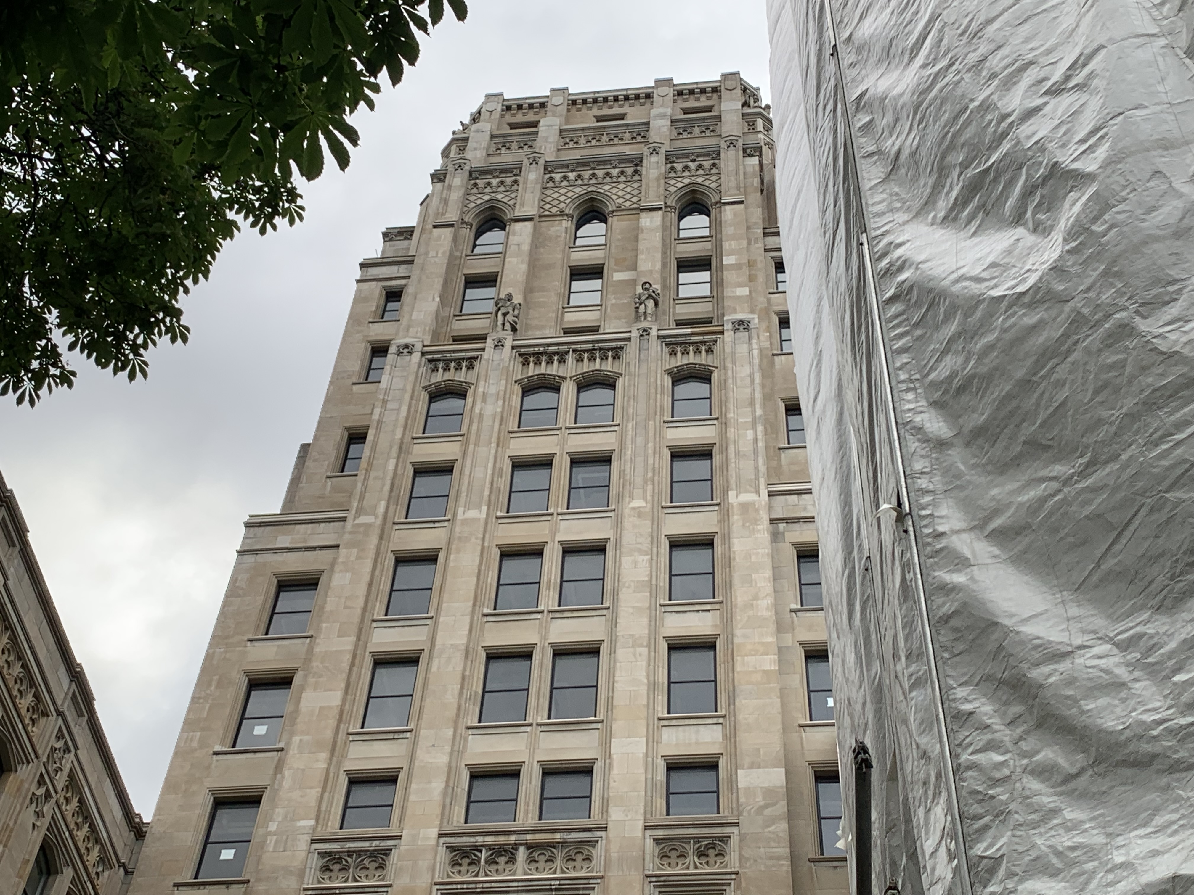
Art Deco architecture became popular around 1915 and had run its course by 1940. One way to recognize Art Deco is the artwork that the buildings are decorated with. These government buildings are no exceptions and display quatrefoils everywhere. A quatrefoil is made of four overlapping circles and in the original Latin context it applied a four-leaf clover. The Canadian Imperial Bank tower is another great example of Art Deco in the city.

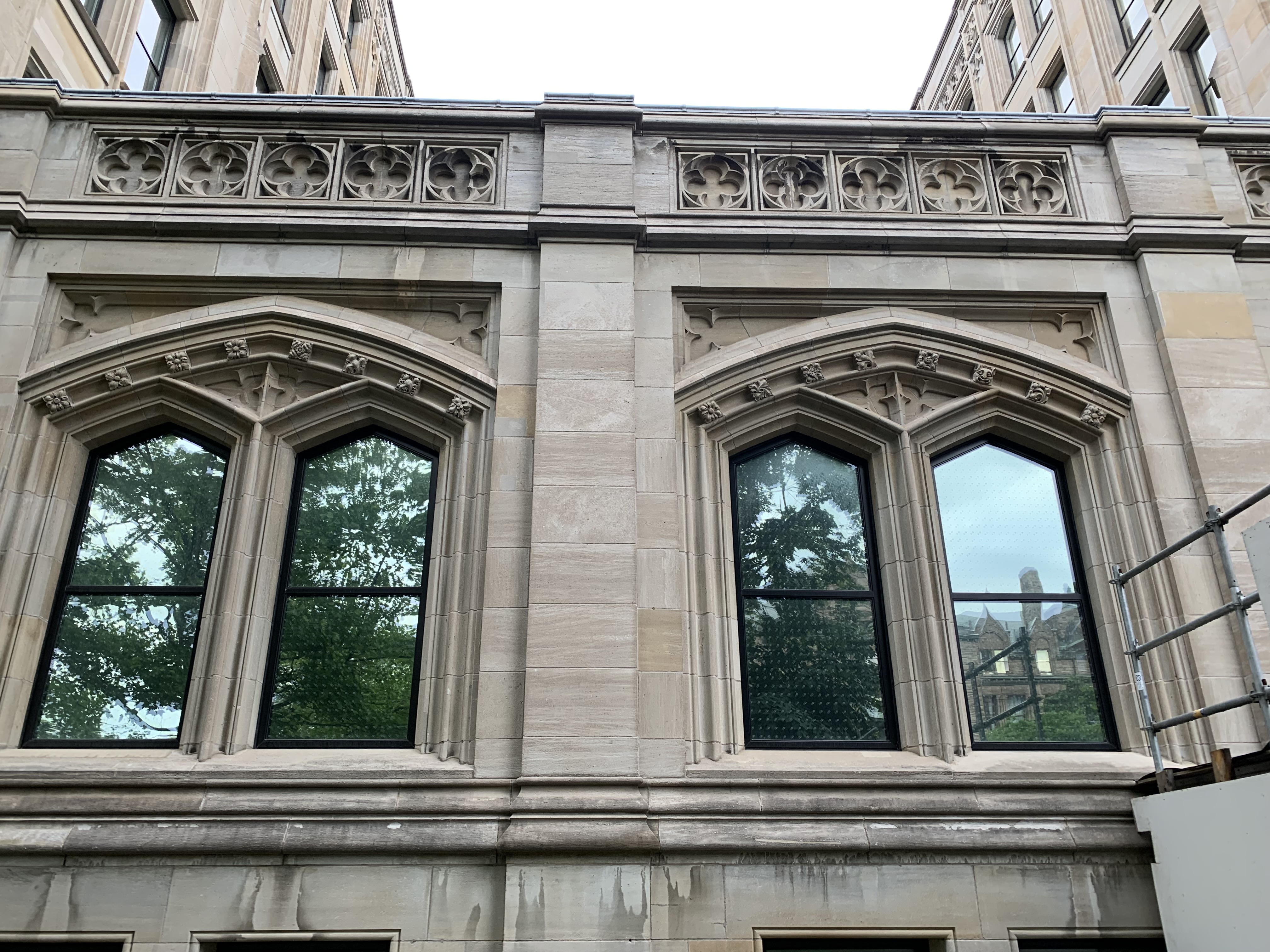
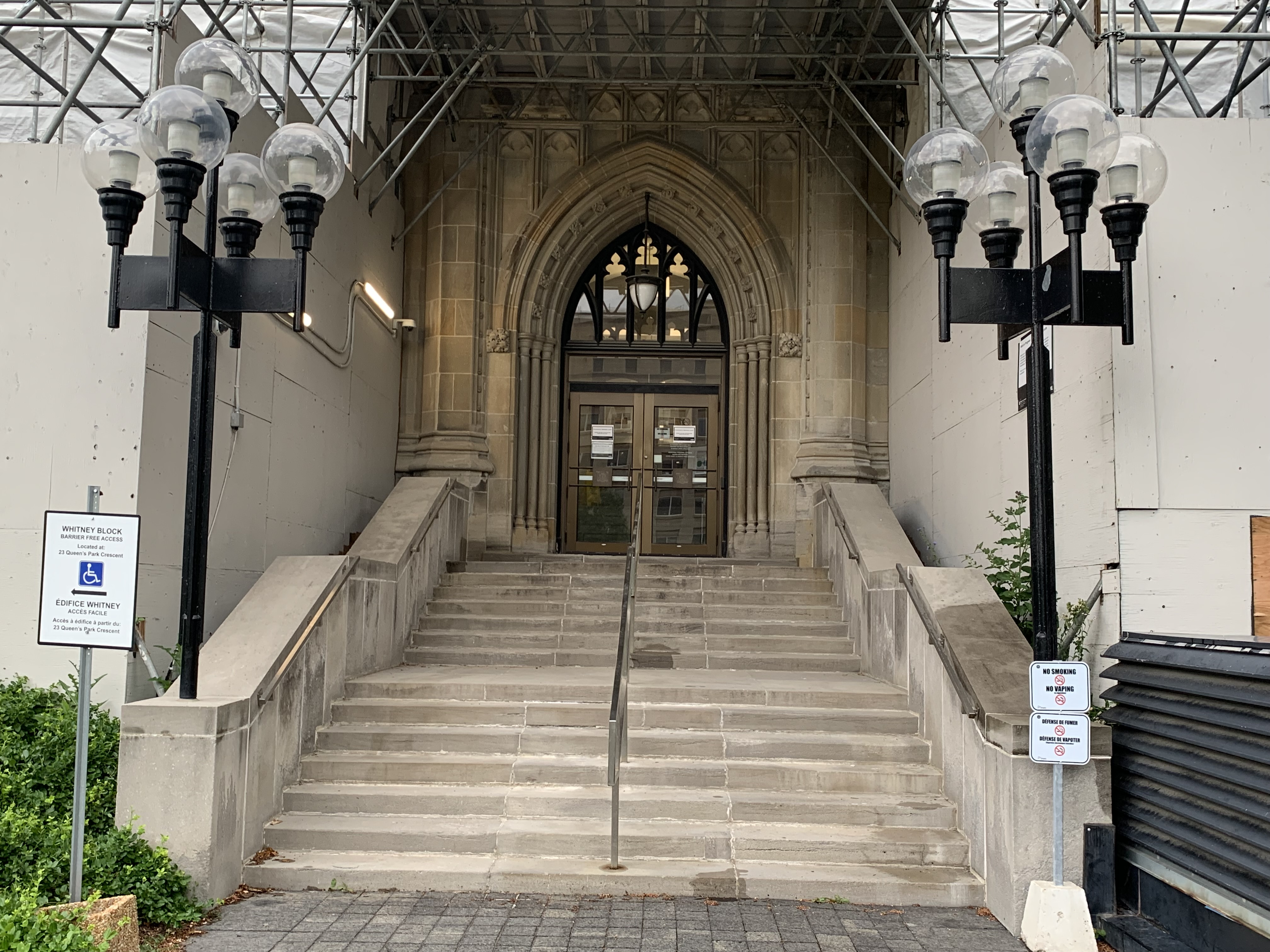
The doorways have a nice Gothic arch which gives each of the buildings an interesting entranceway.

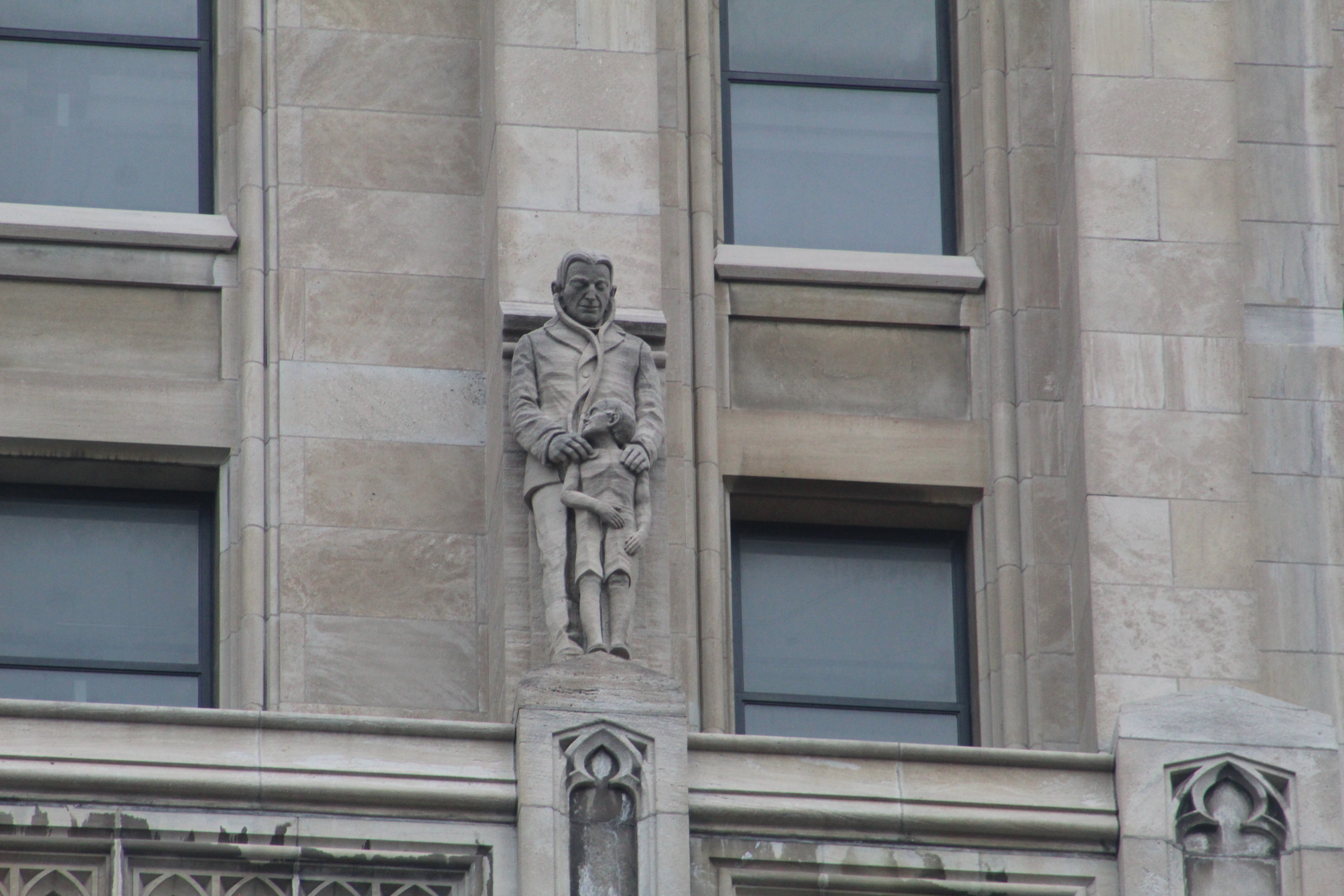
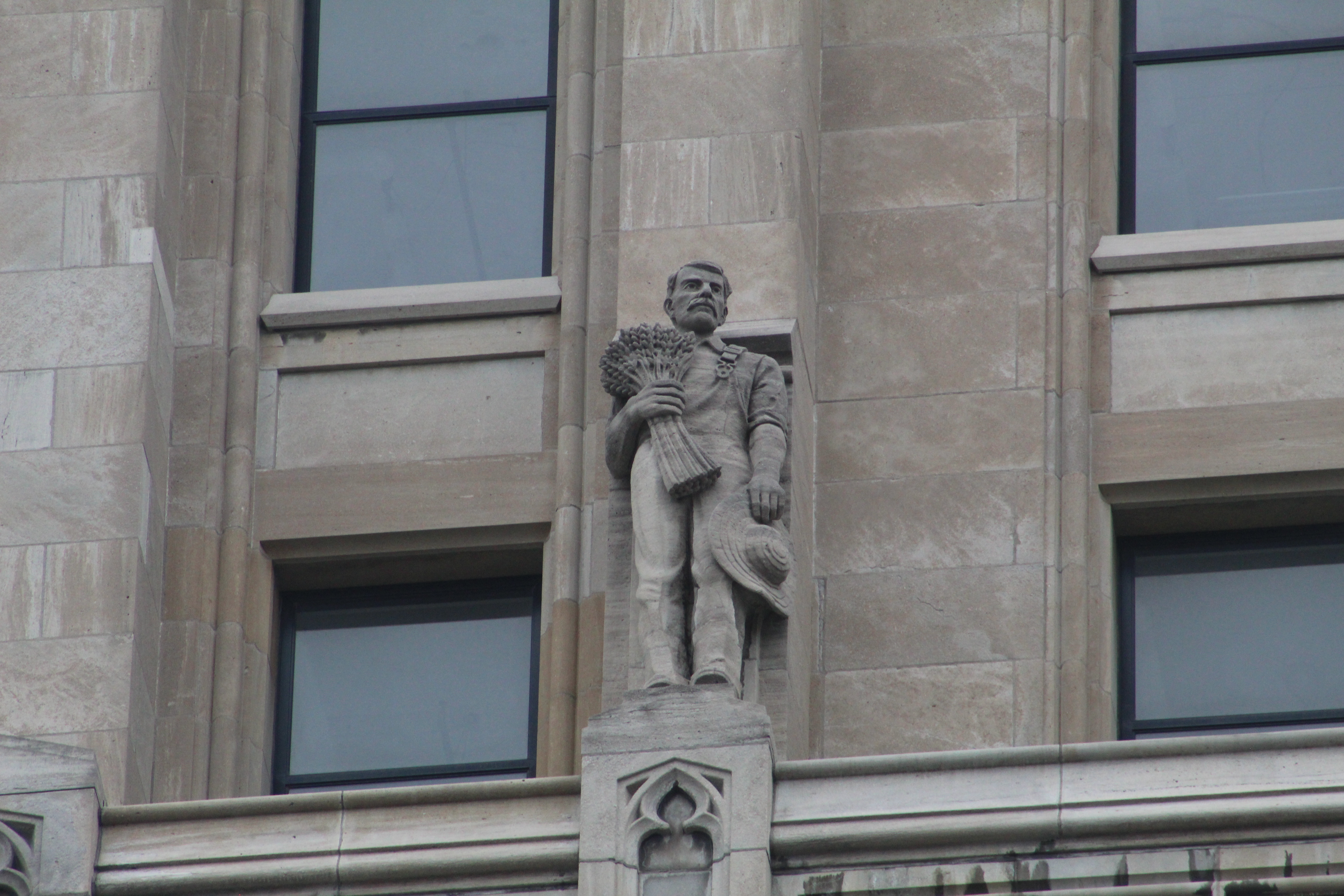
Twelve carvings by Toronto sculptor Charles Adamson adorn the buildings with one each on the four upper corners and two on each side a couple of floors lower.

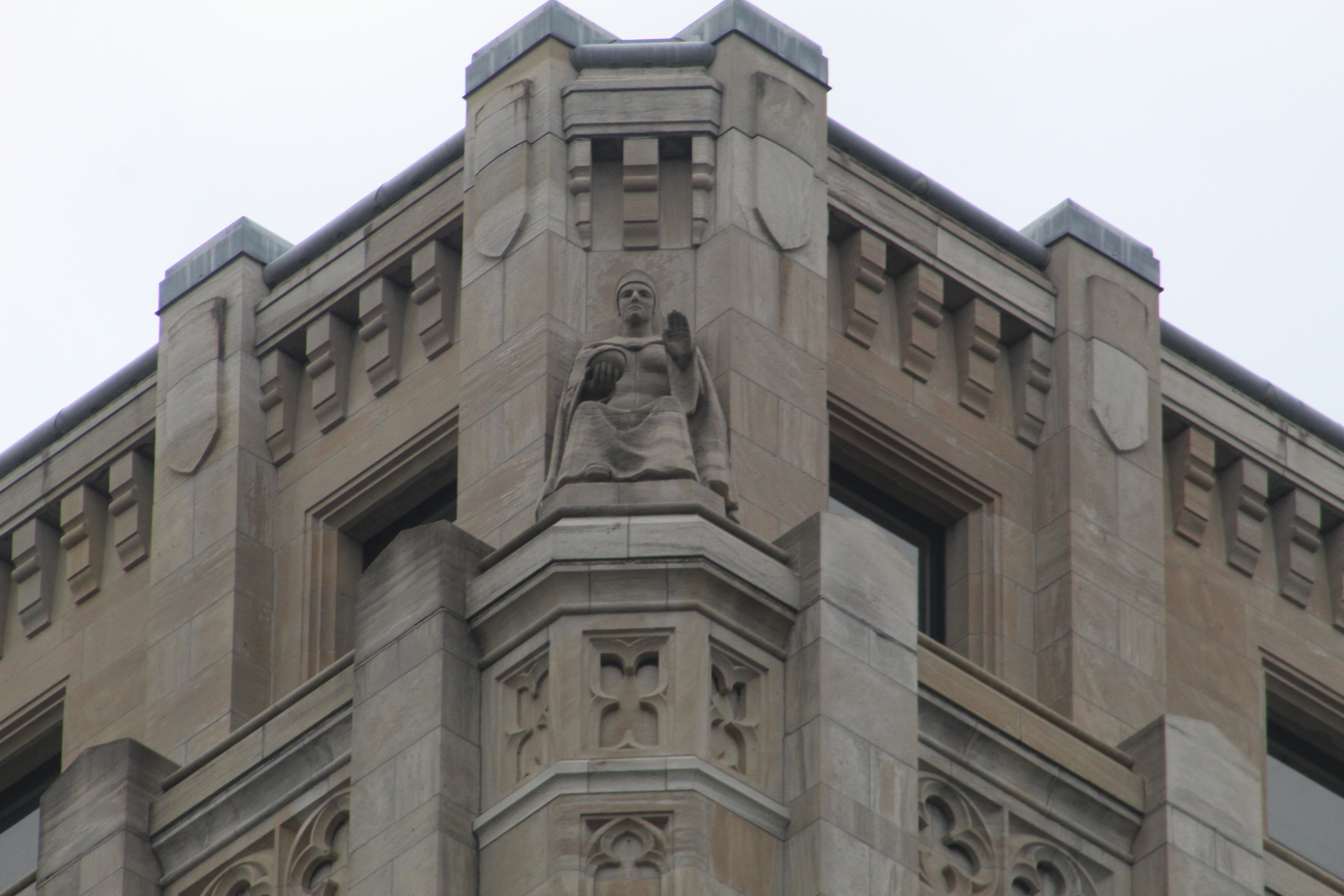
The four carvings on the upper floor are all female and represent Justice, Tolerance, Wisdom and Power (seen below).

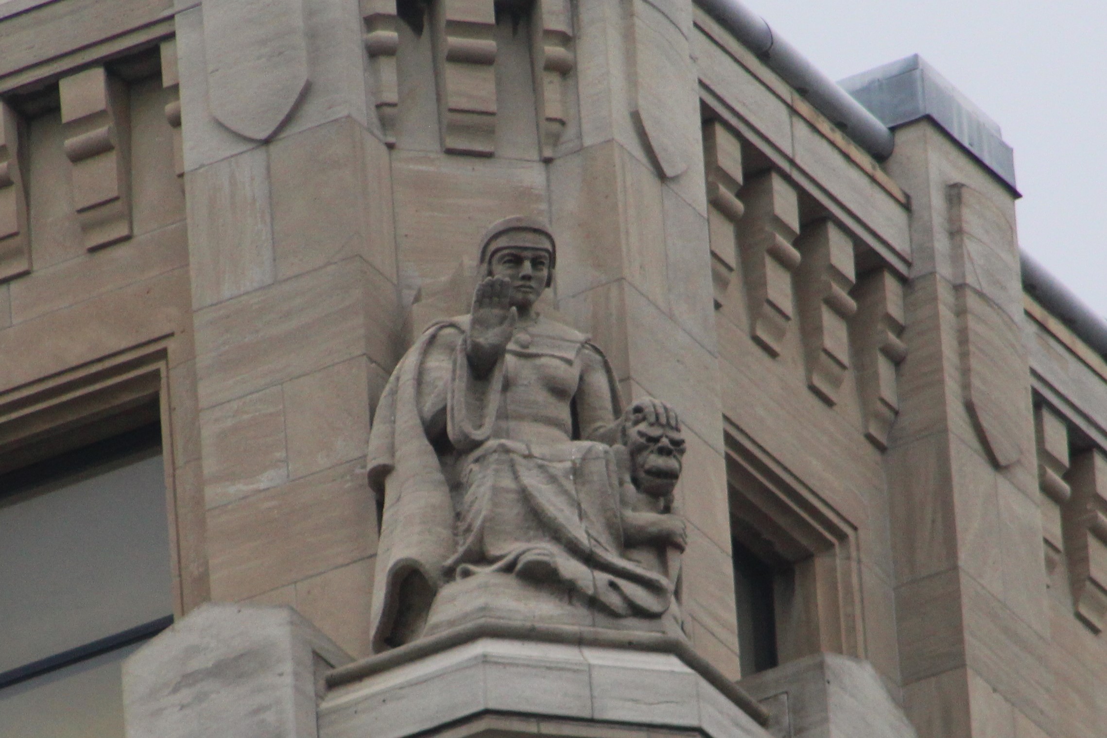
Each side of the building has two male figures set in the following pairs: Farming and Forestry, Law and Education, Labour and Mining and finally Finance and Health with the latter being shown below. The tower had a bowling alley in the basement and an entire floor for animals being kept by the Department of Health. It also still has a hand-cranked elevator, perhaps the last one remaining in the city. Unfortunately, one of the problems with the building was poor ventilation and the only way to get fresh air was to open the windows. Government employees were never happy with the slow elevator and the single stairwell. This lack of egress in case of emergency situations led the building to be deemed a fire hazard. All but the first few floors have now stood empty for over 50 years. The tower was featured in the movie “Chicago” and many claim that the spirit of Francis Heakes still haunts its hallways.

Even before the East Block was completed it was being called The Whitney Block although it would have to wait until 1966 to get the name officially. James P. Whitney was elected to his first term in 1905 as the first Conservative Premier in 33 years. Whitney was elected to four consecutive majority governments winning at least 70% of the seats each time. He died in 1914 shortly after the fourth victory making him the only premier to die while in office. His legacy includes bringing power to Ontario through the Hydro-Electric Power Commission of Ontario as well as passing the Workers Compensation Act. The image below shows the carving “Agriculture”.

This Toronto Archives aerial photo is from 1956 and shows the houses and buildings that used to stand on the south end of the site. These were cleared away in 1958 in preparation for the construction of the fifth and sixth wings.

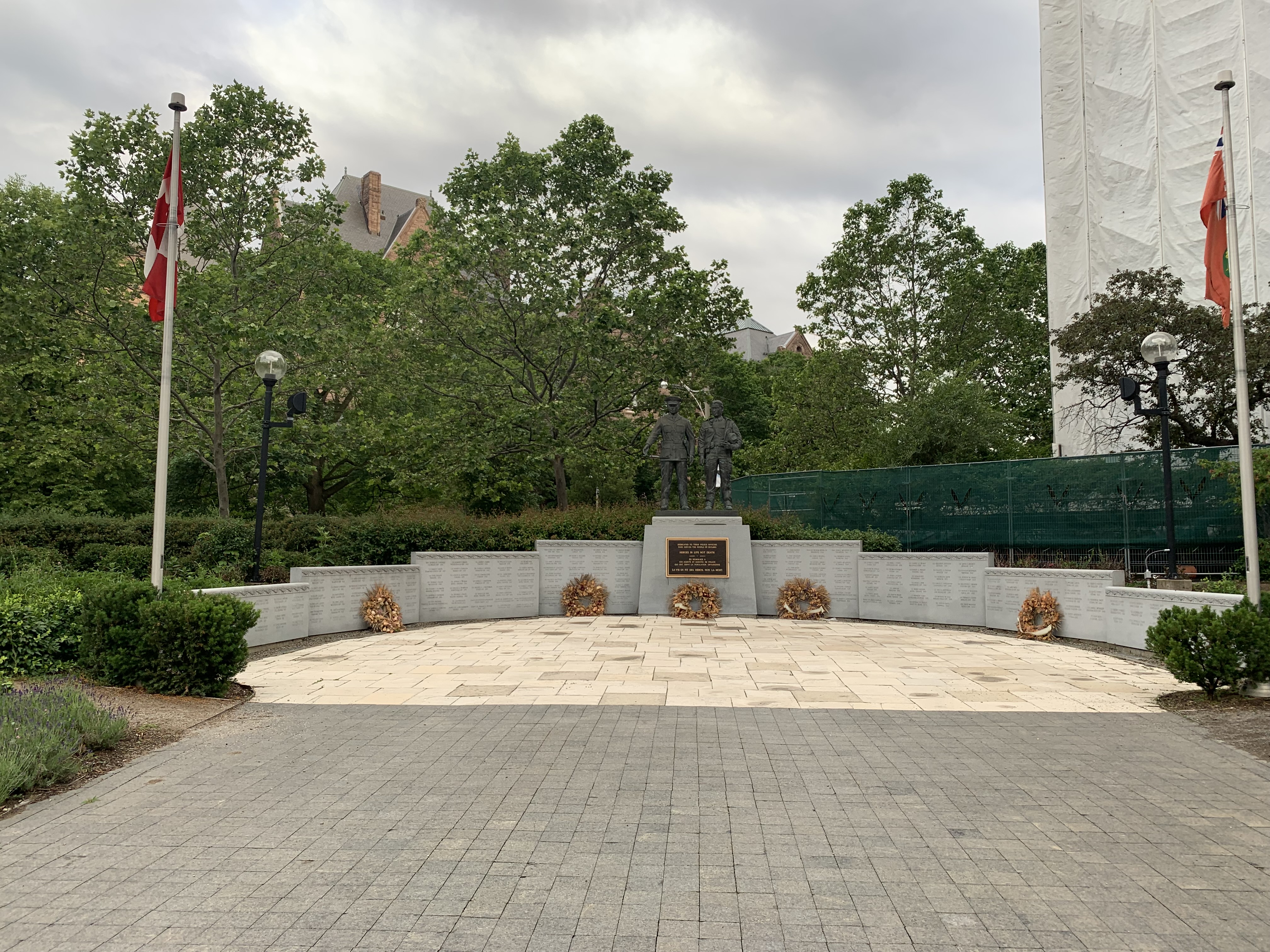
However, even as they were planning the next phase of construction it was becoming obvious that two more 6-story wings would not be enough to meet the needs of the ever expanding provincial government. The idea was scrapped and instead the Macdonald Block was built to the east of the site. It consist of four towers of 24, 14, 14, and 10 stories and like the Whitney Block is currently undergoing a massive renovation project which includes new windows and energy efficiency upgrades. A park was developed on the site and now is home to the Ontario Police Memorial. Below the statues of a male and female police officer are the names of those who died in service.

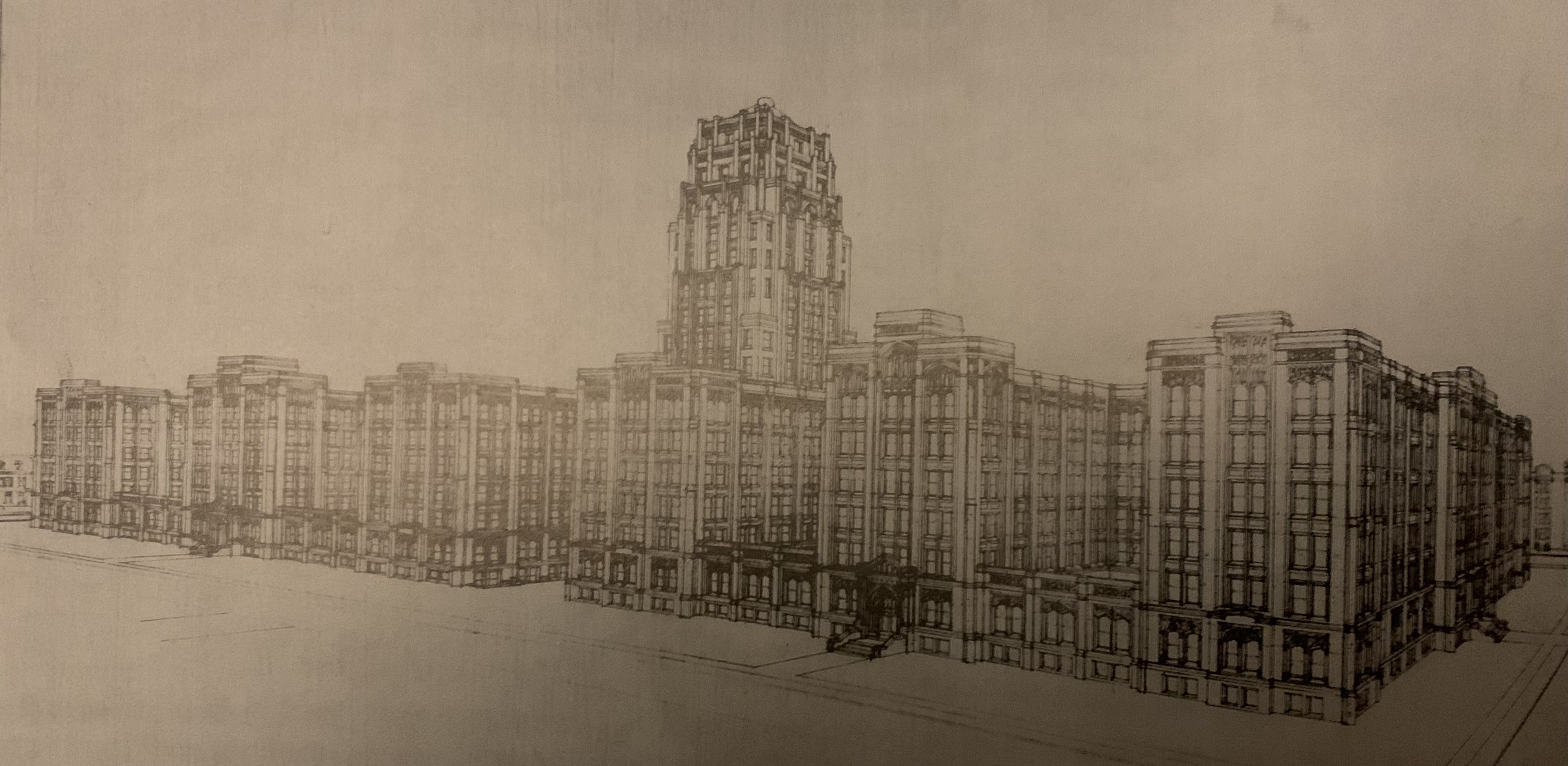
This drawing shows what the Whitney Block would have looked like when it was fully built out. It was taken from the Archives of Ontario and is dated to around 1930.

It’s hard to say what the future holds for this building but the exterior has been kept well restored and perhaps one day a plan will be made to do something with the interior. A proposed exterior staircase on the east side of the building (hidden from Queens Park) and ventilation upgrades might put the tower back into service. However, the single stairway might be adequate if the building was opened for tours and to allow people to get a closer look at the carvings. Time will tell.

Further reading from a little different perspective can be found in these recent articles by Now Magazine and Blog TO

Also see our post on Queens Park

Google Maps Link: Whitney Block

Like us at http://www.facebook.com/hikingthegta

Follow us at http://www.hikingthegta.com

Also look for us on Instagram.

The Battle Of Beaver Dams – June 24, 1813

June 24, 2021

As the War of 1812 entered its second year the Americans had opened the campaign with two quick victories. On April 27th 1813 they had won The Battle of York, capturing the town as well, but had retreated on May 8th to focus their resources on capturing the Niagara Peninsula. On May 27th they landed near Fort George and succeeded in capturing it. Rather than chase the retreating British, the Americans took their time and only reached Stoney Creek on the 5th of June. A daring attack under cover of night led to the British winning The Battle of Stoney Creek and the Americans retreating back to Fort George. We pick up the story a couple weeks later with the key players located as indicated on the Google Earth capture below. The Americans under Brigadier General John Parker Boyd were in Fort George and the British advance guard were at Decew (DeCou) House. Laura Secord was at her family homestead in Queenston.

The Americans were anxious to break out of Fort George and engage the British forces in an attempt to regain momentum. They decided to send 600 soldiers under the command of Colonel Charles Boestler to capture the 50 British troops that were positioned at Beaver Dams.

Meanwhile, Laura Secord was living at this little one story Georgian Cottage since 1803 and would continue to do so until 1835. Her home had already been invaded and ransacked by the American army during the Battle of Queenston Heights in October 1812. Following the victory at Fort George, several officers had been billeted at the Secord home. When Laura overheard plans to make an attack on the British advanced post at Decew House she decided she needed to alert them to the danger. She set out on a 32 kilometer journey on June 22, 1813. One story has her bringing a cow along in case she was questioned and needed an alibi about doing farm work. On a side note, her house was in poor shape by 1971 when the Laura Secord Chocolate Company renovated it in her honour and later donated it to the Niagara Parks Commission.

James FitzGibbon was stationed at John Decew’s stone house near Beaver Dams with one company of the 49th Foot soldiers. After passing through woods and swamps Secord was able to reach him with the aid of some Natives that she encountered. She was able to warn him of the impending attack. The Decew house would have looked much as it did in 1925 in this photo from Wikipedia.

The Decew house was damaged by a fire in 1938 and sat boarded up until 1950 when it was destroyed by another fire. It then was declared as a National Historic Site, somewhat belatedly. The walls were reduced to the height of the window sills and given a concrete topping to hold them together. The basement was filled in with rubble and flag stones laid down for a floor. There’s a plaque installed to describe the history of the house.

Early in the morning of June 24th the Americans set out from Fort George and after passing St. David’s they found a trail to the top of the escarpment. About 300 Khanawakhe (Christianized Mohawks) and another other 100 Mohawks began to close in on the American troops and began to set an ambush. When the Natives opened fire and wounded the American Colonel they sent the troops into a panic for fear of being scalped. This is when FitzGibbons rode onto the battlefield under a white flag of truce. He convinced the wounded Boestler that if he didn’t surrender the Natives would run wild and slaughter the entire American contingent. Based on this claim a surrender was negotiated even though the American troops could have probably carried the day if they had called the bluff. The cairn pictured below was erected in Battle of Beaverdams Park to commemorate the events.

After the battle the Mowhawks claimed 5 dead and 20 wounded while there were 25 Americans killed and 50 of the 489 prisoners taken were wounded. An obelisk was erected in 1874 to mark the graves of 16 unidentified American soldiers that were buried on the battlefield. It was moved to the new Battle of Beaverdams Park in 1976.

Following this battle the Americans would be demoralized and confined to Fort George. For the Americans, the Niagara Peninsula campaign was over for the year. They continued to send out small scouting parties to keep an eye on the British but when they encountered a large reconnaissance force on December 10th they feared an attack was being planned. Brigadier-General George McClure decided to abandon the fort and ordered a retreat across the Niagara River.

First Nations People don’t celebrate wars or victories the way that white people do. They don’t want to relive the battle and usually won’t participate in re-enactments. Their idea is to celebrate the peace that follows the struggle. The Peace Monument at Decew House Heritage Park is intended to help generate an deeper understanding of First Nations People and their culture as well as their contributions to the founding of Canada. The memorial has a couple of children’s stuffed toys in memorial to the recent finding of 215 children buried in a Residential School in B.C.

The Bruce Trail leads directly to Decew House and then to Decew Falls. Decew House is one end of the Laura Secord Legacy Trail with the other end being at her home in Queenston. The trail is 32 kilometers long (20 miles) and is a close approximation of the very route she took as she walked into history. It can be walked in its entirety but has been broken up into five convenient sections for trail users.

The Laura Secord Legacy Trail is described in detail on the Friends Of Laura Secord website.

The Battle of Beaverdams Park is not the actual location of the battle field which was on the other side of the Thorold Tunnel. This new park was created in 1976 on land reclaimed when the Second Welland Canal was drained and filled in. The name “Beaver Dams” was contracted into a single word for the park name. The sides of Lock 25 can be seen in the picture below and it was the highest elevation Escarpment lock on the canal, which had opened in 1845. The monuments were moved from the actual battlefield to this site but the American soldiers remain interred where they’ve lain for over two centuries.

The anchor on display in the park is also a reminder of the days when ships used to pass through here on their way between Lake Erie and Lake Ontario.

Details of the War of 1812 many be unknown to many Canadians but few people haven’t heard of Laura Secord because she has become a celebrated heroine of the conflict. Or is it just because of the candy store? We hope not.

Other War of 1812 Stories: Battle Of Queenston Heights, Battle of York, Battle of Stoney Creek

Google Maps Link: Battle of Beaverdams Park, Fort George, Laura Secord House, Decew House

Like us at http://www.facebook.com/hikingthegta

Follow us at http://www.hikingthegta.com

Also look for us on Instagram

Ghost Towns of York Region

Sunday, June 20, 2021

York Region has many small communities that have shrunk from their late 1800s sizes and faded almost into oblivion. They have lost their industry, blacksmiths and hotels and usually their stores as well. We refer to these as ghost towns although in the strictest sense they aren’t really. This blog collects 7 of the ones that we have visited and arranges them in alphabetical order. Each has a picture that represents the community as well as a brief description. The link for each will take you to a feature article on the community which has the local history as well as pictures of any surviving architectural features. At the end of each feature article is a google maps link in case you should wish to explore for yourself someday. Future companion blogs in this series will cover the ghost towns of the Peel Region, Halton Region, and the City of Toronto.

Cedar Grove still has it’s historic school and Lapp’s Cider Mill but the real treasure is Cedarena. The skating rink operated from 1927 until 2015 and now it sits waiting for skaters who never show up.

Elders Mills formed around a crossroad and thrived for a couple of decades before it went into decline. Several of the original houses and the 1872 school house still remain. A couple of the houses as well as the school have been incorporated into new structures which has saved them from demolition. The homes on the farms around the town have been removed as the land has been cleared for housing.

The former community of Laskay has declined considerably and now the old Methodist Church is a home. A few historic buildings still line the street but the best preserved of all is the old Laskay Emporium which serves as an fine example of a country store and post office at Black Creek Pioneer village. Filled with period merchandise it is a real blast from the past.

Maple has grown into a larger community but there’s still lots of older homes and the historic train station to remind us of the small town that started in the early 1800s. There’s also this amazing log home built with massive timbers that hides in a woodlot on the edge of town.

Ringwood has a lot of abandoned buildings including this 1887 school house which has some interesting wood paneling on the front. At that time, the population was 300 but began declining almost right away until within a few decades there were only 13 students in the school.

Sherwood was larger than Maple at one point but quickly faded into a couple of churches and a few homes. Most of these have since been demolished in order to build a large train switching facility. The Zion Evangelical Church still holds services and has an extensive pioneer cemetery.

Every Ghost Town has its pioneer cemetery where you can check out the old grave markers and remember the people who lived there a couple of hundred years ago. Some even have markers or cairns for Indigenous Peoples who lived here centuries ago and are buried within the community. Teston has both types of burial grounds but neither is well marked and even the pioneer head stones are missing.

Compared to Toronto and some of the other surrounding areas, York Region has still got quite a bit of its pioneer heritage in place.

Other ghost town collections: Ghost Towns of Toronto, Ghost Towns of Peel Region, Ghost Towns of Halton Region.

Like us at http://www.facebook.com/hikingthegta

Follow us at http://www.hikingthegta.com

Also look for us on Instagram

The Grand River In Galt

Sunday, June 13, 2021

The Grand River is one of our Heritage Rivers and has been a means of travel and a source of power for centuries. William Dickson came to the Grand River area in 1816 and bought 90,000 acres of land with the intention of establishing a town and developing his land holdings. He built a mill at the confluence of Mill Creek and The Grand River and established Shade’s Mills which would be renamed Galt by 1827. The river made it possible for the establishment of Galt as an industrial centre. The residents built their early community along Water Street, an aptly named roadway.

There’s lots to see in the old town of Galt but this post focusses on the buildings along Water Street. I parked in the parking lot near the Mill Restaurant and walked south along the river. The county atlas map below shows Galt in 1877. I’ve coloured the river blue and the section of Water Street that I explored is coloured green.

There has been a dam on the Grand River in Galt since 1837 when water was first harnessed for power in the Dickson Mill. This same dam would also provide power to the Turnbull Woolen Mill and several other downstream establishments.

The Dickson Mill was built in 1843 and named after Robert Dickson who was a son of Galt founder William Dickson. When its milling days were over it was converted into the Galt Gas and Light Company which generated electricity to light the streets and homes of town. They operated between 1889 and 1911 when power arrived in town from Niagara Falls. In 1980 it was converted into The Mill Restaurant.

In 1974 there was a severe flood which caused damage to the riverbank and several historical structures along Water Street. This led the city to form a riverbank development program which saw the creation of Mill Race Park along with other stabilization projects. Robert Turnbull and John Deans had operated a knitting mill in Galt since 1859 and had taken over the old Wardlaw Mill on this site and used it between 1890 and 1897 when it burned down. It was rebuilt and operated under various names until 1972. The ruins have been incorporated into an amphitheater and park area for use by everyone.

The mill race carried a flow of water from the dam and along the side of Water Street where it was used by a series of mills. The turbine still remains in the mill race beside the old Turnbull Woolen Mill. Water rushed through a penstock at the bottom of the mill race to turn the turbine. It turned the belts that ran on the smooth wheels and supplied power to the knitting mill.

Morris Lutz built this Georgian style limestone house in 1850. Lutz had arrived in Galt in 1844 and became part of the Dumfries Foundry where he was foreman in the machine shop. Morris was elected to the first town council and when Galt was incorporated as a city in 1857 he was the first mayor.

Galt got a new post office in 1936 which replaced the one that still stands a little farther down Water Street. This handsome stone building with clock tower has been home to the post office ever since.

The Bank of Toronto opened a branch on Water Street in 1912 and this Beaux-Arts style building is unique in town. It has white glazed tiles on the exterior that are similar to pottery, another example of bank buildings that were designed to stand out from their neighbours.

Andrew Carnegie donated $23,000 for the construction of a new library for the Town of Galt in 1905. Carnegie gave away 90% of his fortune which is roughly $5.2 Billion in 2021 value. He funded about 3,000 libraries in the belief that libraries should be free to the local community. This Beaux-Arts style building housed the library for over 60 years and has since been home to several businesses. It is currently available for lease.

The First Delta Baptist Church was built in 1887 and is a mixture of Romanesque and Italianate styles. In Ontario it is rare for a church to be built with river or waterfront property. Usually they are on side streets, often conveniently named Church Street. The Baptist congregation formed in Galt in 1851 and they met in houses until 1872 when they started using the Primitive Methodist building. Robert Scott donated the land for the church which was deconsecrated in 1980 and then sold to the city for use as a theatre.

This archive photo shows the Baptist Church in 1902. It is interesting to see how the building has changed over the years. The main alteration is the elimination of the two doors on either corner and the opening of a central doorway. The side doors have been bricked in to disguise the fact that they ever existed. The new central door has also been closed in during the intervening years. There appears to be a new small window in between the two buttresses beside the new doorway.

George Landreth arrived in Galt in 1831 and found work in one of the many mills in town. He had this Georgian Cottage built in 1858 and it still has its original doorway with the multipaned side lights and transom. Along with the Lutz home featured above, it is one of just two original homes that remain in the original core of Water Street.

The Imperial Block was built in 1887 and was almost like an early strip mall. This Romanesque Revival structure at one time was home to the Commercial Bank, a grocery store, a tailor shop, a dress maker, tobacco dealer, hairdresser, dentist and a music store.

Scott’s Block was built in 1890 in the Romanesque Revival style. It has a terra cotta tower on top and detailed brickwork on the front. A two story oriel window stands out from the crowd of historic buildings on Water Street.

The Galt Woolen Factory is the oldest surviving textile mill in the city. It was built in 1843 for Isaac Sours who operated it until 1852. During this time his employees worked an average of 64 hours per week. In 1881 it became the Tiger Brand Knitting Company and today has been converted into offices and apartments.

In 1885 the Federal Government commissioned a new post office for Galt which was also used for as a Customs and Inland Revenue Office. It has some of the most interesting masonry work of all the stone buildings in Cambridge which has been preserved in the restoration and expansion project that brought the glass section to the rear.

Partial ruins of old mills and factories line both sides of Water Street and there is a great deal of history being retained in creative ways. Plenty of communities could learn from this example. The Canada Machinery Corporation had a Pattern Works Shop and Stores building beside the river where it forged machinery parts. They operated until 1979 and in 1984 the remains of their building were incorporated into another public park with its history intact.

The Galt branch of the Great Western Railway opened in 1854. Some portions of the former right of way along Water Street can still be traced and the old stone abutments can be seen where it crosses a small creek.

This blog is focused on Water Street and really doesn’t get into Main Street and some of the other parts of town. If you explore these areas you will find the 1857 Town Hall, the 1838 Dumfries Township Hall and the old Galt Firehall among the many interesting buildings in town.

Other Grand River stories: The Shand Dam, The Elora Gorge, West Montrose Bridge (Kissing Bridge)

Google Maps Link: Mill Race Park Cambridge

Like us at http://www.facebook.com/hikingthegta

Follow us at http://www.hikingthegta.com

Also look for us on Instagram

The Battle of Stoney Creek

June 6, 1813

The Battle of Stoney Creek may not have been significant in terms of the number of combatants or in casualties but the outcome had a profound impact on the course of the War of 1812. The war had entered its second year with the Battle of York on April 27th, 1813. Capturing York might have been good for morale after the series of losses the Americans had sustained the previous year, but holding it didn’t have great military purposes. So the Americans had withdrawn and focused their attention on capturing the Niagara Peninsula. On May 27th a force of 7,000 men had attacked Fort George with the support of 16 warships. The fort was captured and the British forces of 1,800 men had retired to Burlington Heights where they had dug in to make a defensive stand. The map below was taken from Pierre Burton’s War of 1812 and shows the formation of the battle.

The American forces slowly made their way up the peninsula from Fort George and by the night of June 5-6 had arrived at Stoney Creek. They camped on the property of James Gage who lived with his mother and his wife in their family homestead. Mary Jones Gage had moved to Canada in 1790 and had been building their home in stages since 1796. They had originally lived in the basement while the upper levels were being built. The Americans commandeered their house as a headquarters for Brigadier General John Chandler and had locked the Gage family in the basement.

Billy Green and his brother Levi spent the afternoon of June 5th tracking the advancing army from the top of the escarpment and scaring them by howling in the woods and pretending to be natives. Billy’s brother in-law Isaac had been taken prisoner by the Americans but had been released after claiming to be related to William Henry Harrison, the US President. They gave him the password of the day which he then shared with Billy. Armed with this information, Green made his way to the British camp at Burlington Heights.

Convinced that a surprise attack under cover of night was the only hope for the British due to their much smaller forces, they set off to march to Stoney Creek. The British removed the flints from their guns to prevent accidental firing so as not to alert the Americans of their approach. When they arrived in Stoney Creek they found that a sentry had been posted at the Methodist Church. While giving him the password, Billy Green dispatched him with his bayonet. The plan was to sneak into the camp and kill as many sleeping soldiers as possible by bayonetting them. Instead, the British started yelling in their excitement and the whole camp was awoken. A confusing battle ensued in the darkness with the British capturing four of the six the American field guns. One after the other, both of the American leaders approached the guns to see why they weren’t firing and were captured by the British. Eventually both sides retreat convinced the other side had won the battle.

The American forces retreated to Fort George where they were trapped until the end of the year at which time they slipped back across the Niagara River and returned home. With the exception of another loss at The Battle of Beaver Dams on June 24th, the American campaign on the Niagara Peninsula was over for the year.

Battlefield House has been restored as a museum and is furnished to illustrate life at the time of the war. There’s also plenty of artifacts to help illustrate the battle and these can be viewed as part of a guided tour. The picture below shows the back of the house as seen from the base of the monument.

Sara Calder was the great grand-daughter of Mary Jones Gage and had been born in 1846. When the Wentworth Historical Society had been formed in 1888 she was the president of the ladies committee. In 1899 the women broke away and formed the Women’s Wentworth Historical Society. Later that year they purchased the Gage Homestead for $1900.00 and on October 23, 1899 Battlefield Park was opened. The ladies began planning for a monument to mark the site of the battle and a corner stone was laid on May 26, 1910. With their $5000.00 grant expended, work on the tower was stopped after a year with just the first 25 feet built. It would take another $10,000.00 and three more years to complete the project.

It was 1:25 p.m. on June 6, 1913, exactly 100 years after the battle, that the monument was officially opened. Queen Mary, consort to King George V, pressed a button in Buckingham Palace and a signal was sent along a telegraph line to drop a shroud and reveal the monument.

The tower has been closed since the pandemic began but as I was the only visitor when I was there physical distancing wasn’t a problem and I was allowed inside to see the ground level displays. Regular safety inspections of the stairs had not been completed for months and so I wasn’t allowed to climb to the top. Perhaps another time I’ll have the opportunity to check out the view. Meanwhile, I love the castle doors at the base of the monument.

Allan Smith was plowing his field in 1899 when he started to find human bones in a small knoll. Scraps of cloth and buttons also came to the surface indicating that both British and American soldiers had been buried there. The plot of land became locally known as Smith’s Knoll and was consecrated as “Soldier’s Plot” on May 3, 1908. A cairn with a lion on it was dedicated on August 1, 1910. The pictures for this story were taken on November 6, 2020 which is why the trees are in their fall colours.

The Nash-Jackson house was built in 1818 and formerly stood at the corner of King Street East and Nash Road. Five generations of the Nash family lived in the home and an earlier home on the property was used as a field hospital following the Battle of Stoney Creek. The city was deeded the house in 1996 and moved it to Battlefield Park in 1999.

The Battle of Stoney Creek was a turning point in the war and the Americans would never again penetrate as far up the Niagara Peninsula.

Related blogs in our War of 1812 series: Battle of York, Battle of Queenston Heights

Google Maps link: Battle of Stoney Creek

Like us at http://www.facebook.com/hikingthegta

Follow us at www/hikingthegta.com

Also look for us on Instagram