Monthly Archives: April 2020

Mink Kits

Friday, April 24, 2020

American Mink can be found along the shorelines of lakes, rivers and creeks throughout the GTA.  They generally live alone except for mating season which begins in February.  The kits are born from mid-April to June in litters that average 4.  The American Mink has a short delay between insemination and implantation which means that the female can delay the start of gestation for up to 45 days while she waits for favourable weather conditions.  With a mild winter and early spring it will tend to lead to earlier births than would be the case in years where there had been a severe and late winter.  The picture below shows a mink swimming with a kit in its mouth.

IMG_9666 b

Mink don’t hibernate and so they can be seen all winter and their tracks tend to reveal where their nests are.  One lives in my area, I won’t say exactly where because of the babies, and so I went to see if I could get a picture of it since I am now laid off on Fridays.  I was lucky enough to see it return from a foraging trip and swim back to the nest.  Then it emerged a few minutes later with something in its mouth and swam across the creek.  When it climbed up on a rock in mid-stream I got a picture which showed that it was carrying a baby.

IMG_9724

It took the kit across the creek and into a different den among the rocks on the other side.  Mink are known to keep several dens, each with multiple exits for security.

baby mink 1

Mink babies are born blind with just a fine layer of soft grey fur.  When the kits are about 25 days old they will open their eyes for the first time. This allows them to start to learn the skills of hunting for food so that mom can wean them at about 35 days.  These little ones still have their eyes closed.

mink 5

Over the next few minutes she brought four kits to the new den.  After the third one she paused to collect a few more leaves for padding before going after the fourth.  She stopped and took one final photo op before disappearing into her nest to suckle the young ones and warm them up after their dip in the cold water.

mink 4

American Mink can often be found along the shore of Lake Ontario where they build their home in among the rip rap that is used for erosion control.  This picture was taken in Colonel Samuel Smith Park in Etobicoke.

img_5781

This one was photographed in the winter during our exploration of the Ghost Town of Mount Charles.

img_0237

Seeing a mother mink moving her recently born kits is one of those opportunities that you only get if you happen to be in the right place, at just the right time.  We’re glad we captured this in pictures.

Google Maps link: Do not disturb!

Like us at http://www.facebook.com/hikingthegta

Follow us at http://www.hikingthegta.com

Look for us on Instagram


Birds of the GTA

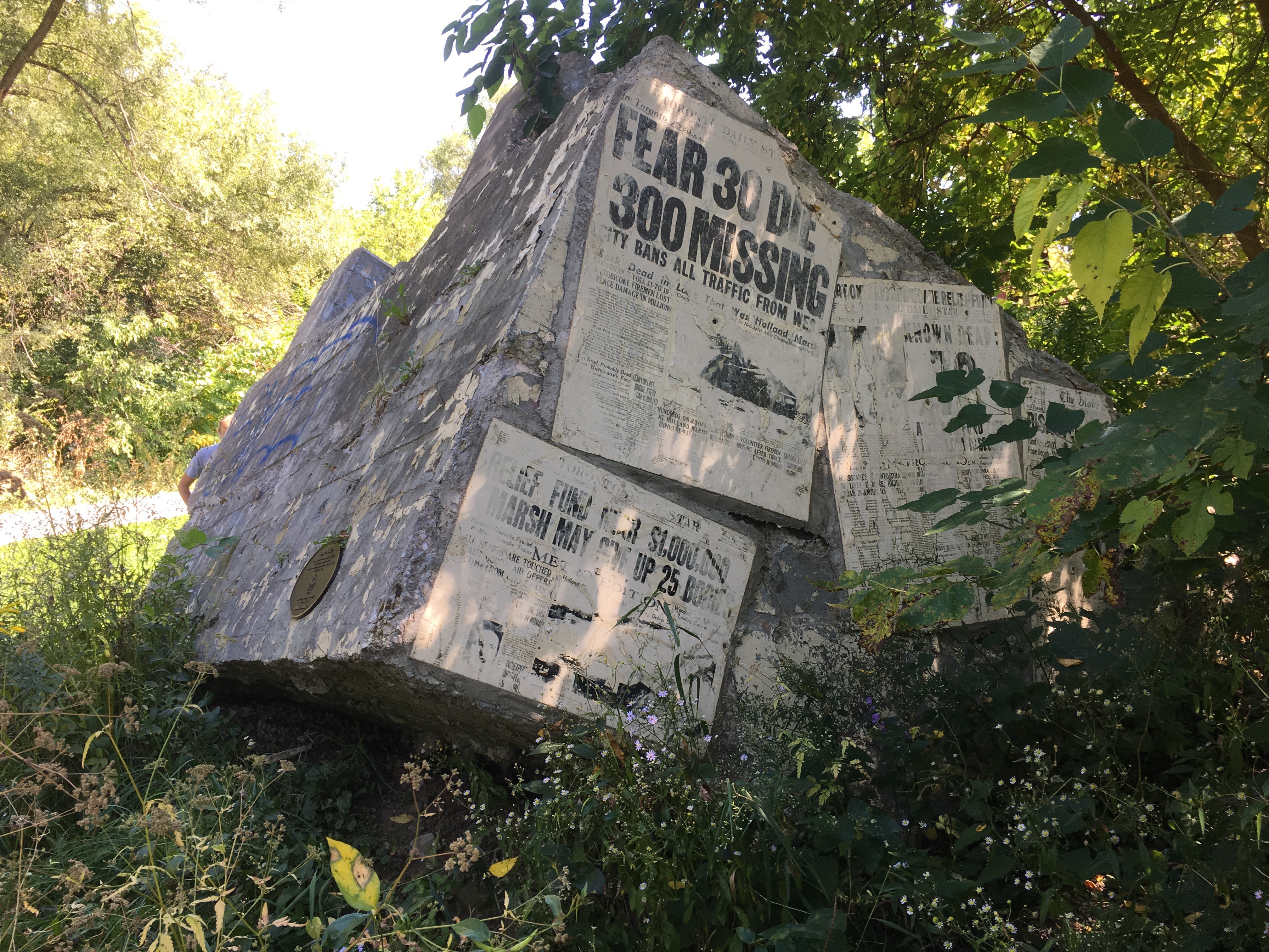
Sunday, April 26, 2020

After hiking weekly for many years, and blogging about it for the past 6 years we have been shut down for over a month now due to the global pandemic.  With no current hikes to present, we are now looking to find other material for blogs.  For our fourth COVID-Blog we’ve collected some of the bird pictures we’ve taken along the way.  A few have appeared in our previous posts, some have been used on our Facebook page as cover or profile photos and a couple may not have been published before.  Savour a taste of the nature that is waiting for us when we’re able to get out and enjoy it.

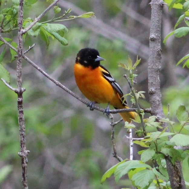
The Baltimore Oriole is the state bird of Maryland and is named after the colours of the coat-of-arms for Lord Baltimore, who was the first proprietor of the Province of Maryland.

Baltimore

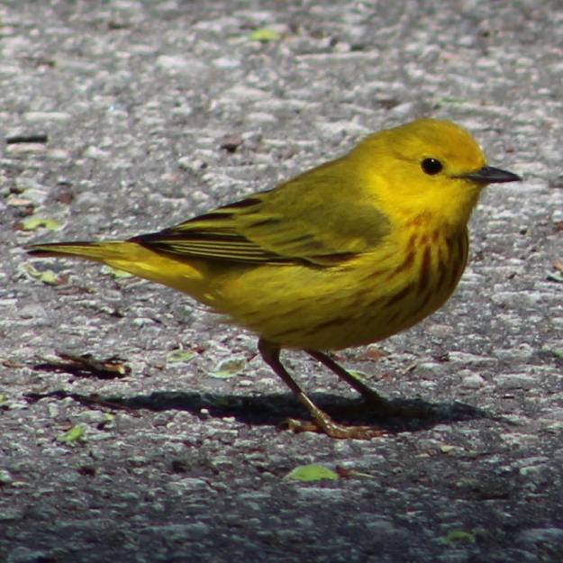
Yellow Warbler males have reddish-brown markings on their breast and can grow to be around 12 centimetres in length.

Yellow Warbler

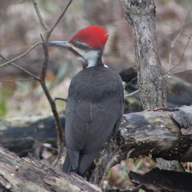
Pileated Woodpeckers are the largest species of woodpecker that is native to Ontario.  Both the male and female have a bright red crest that sweeps off the back of the head.  The male is distinguished by the red stripe on the cheek, as seen on the specimen below.  Their main food is the carpenter ant and they dig large square holes in trees to look for them.  The mated pair stay in their territory all year long and tend to nest in the largest tree in the area.  For this reason they are prone to being killed in lightning strikes.

pileated

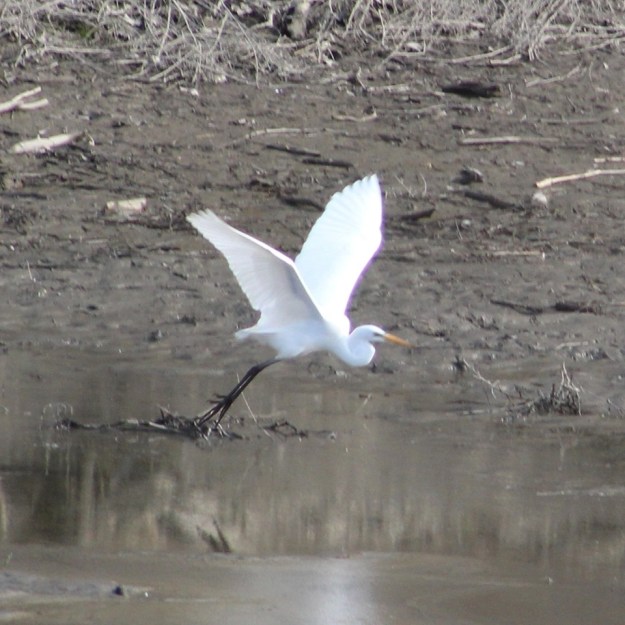
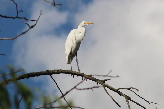
Great Egret are known to breed in colonies with their nests at least 10 feet in the air and as high as 40 feet.  Their main diet is fish and frogs which they spear with their sharp bill.

egret

Another shot of an Egret, this one standing on a tree in G. Ross Lord Park looking into the Don River.

egret

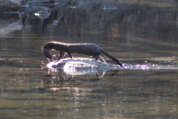
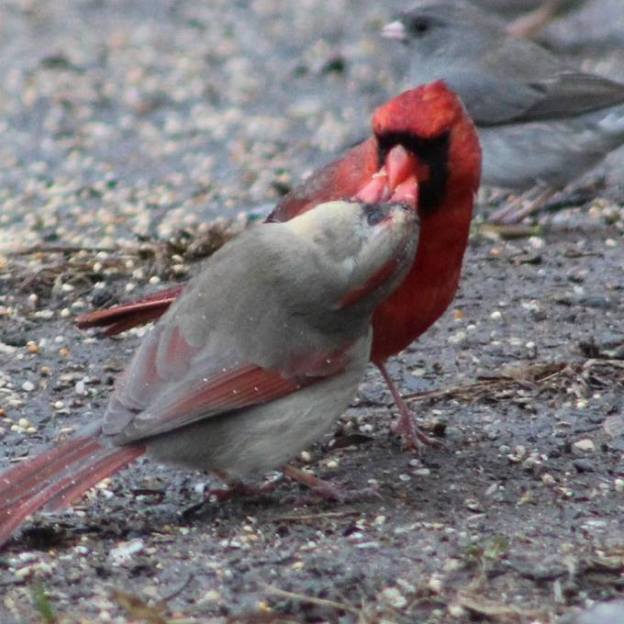
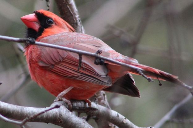
Male Cardinals are at their brightest red in the spring when mating season is underway.  Their courtship includes feeding the female seeds that he collects.  This is captured in the cover photo for this collection.  After the eggs are laid the male will use his bright colours to capture the attention of potential threats.  He will then proceed to lead them away from the nest, at his own expense if need be.

cardinal

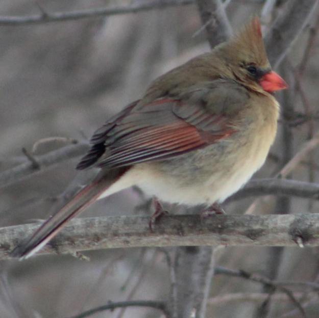
Female Cardinals are paler in colour and therefore can hide themselves easier than the males.  They will sit on the eggs for 11-13 days until they hatch.  During this time the male will bring them their food.  Cardinals remain in pairs year round and the two are seldom far apart.  They have different calls which allows you to hear them as they sing to each other.

female cardinal

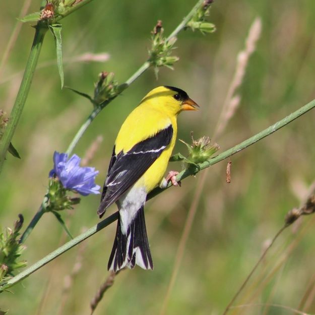
Like the Cardinal, the American Goldfinch is sexually dimorphic, meaning that the male and female look different in more ways than just their reproductive organs.  The male also undergoes a complete molt in which its olive coloured feathers are changed for bright yellow for mating season.

goldfinch


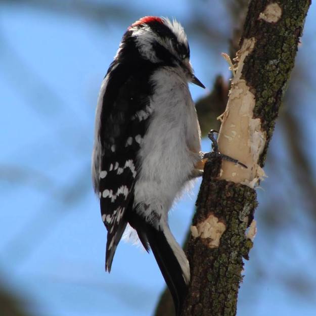
Downey Woodpeckers are the smallest of the common woodpeckers in Ontario.  Except for size, they look almost identical to the larger, and unrelated, Hairy Woodpecker.  The male has a red crest on his head that the female lacks.

Downey

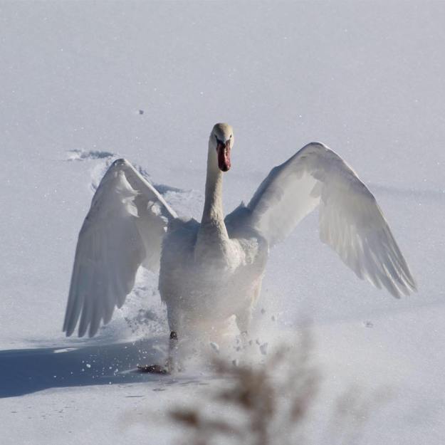
In recent years there have been an increasing number of Swans who choose to spend the winter along the shores of Lake Ontario.  This one was sitting on the fresh snow and was comical as it struggled to take flight.

swan

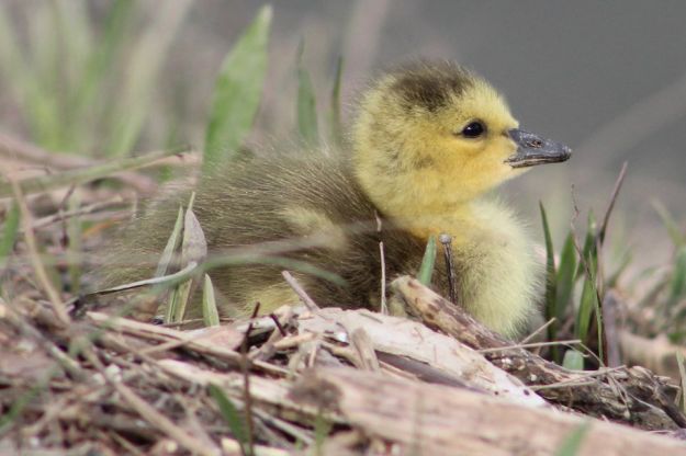
Canada Geese may grace our $100 dollar bill but in general they are pretty dirty birds that some people rather dislike.  However, who could dislike their cute little goslings when they are a few days old.

Goose

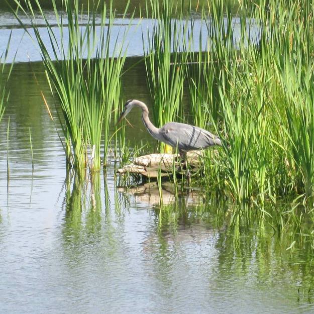
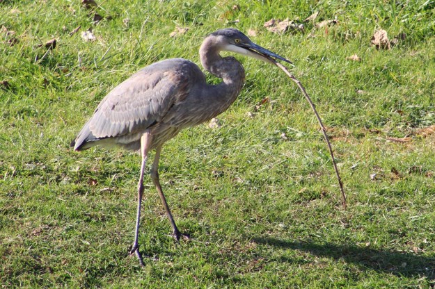
Great Blue Heron are one of the more common of the large fishing birds.  We see them all summer long.  This picture became the background for the Hiking the GTA business card.

Heron 1

Herons have been known to gather sticks for nesting purposes but this one was just picking them up and throwing them off the grass.

IMG_8040

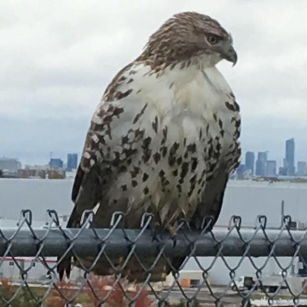
This Red-Tailed Hawk was seen at Downsview Park where it is common to see several hawks in a single visit.  For some reason this one didn’t seem alarmed that I was slowly approaching and taking pictures.  It let me get quite close before taking to flight.

hawk 1

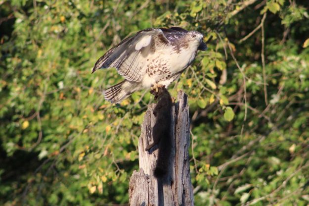
This Red-Tailed Hawk went into the trees near me and snatched a black squirrel off a branch.  It killed the squirrel quickly so that it couldn’t struggle and escape but this was also merciful.  It then spent several minutes making sure it wasn’t going to be challenged for dinner.

hawk and squirrel

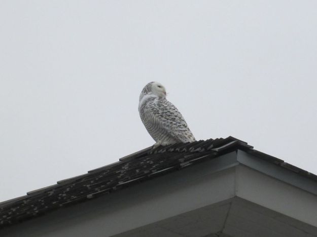
Snowy Owls spend their summers north of the Arctic Circle hunting lemmings.  Each bird can consume up to 1600 lemmings per year.  It is normal for a few Snowy Owls to be seen in Southern Ontario each winter.  This one was seen near the Adamson Estate.

Snowy Owl

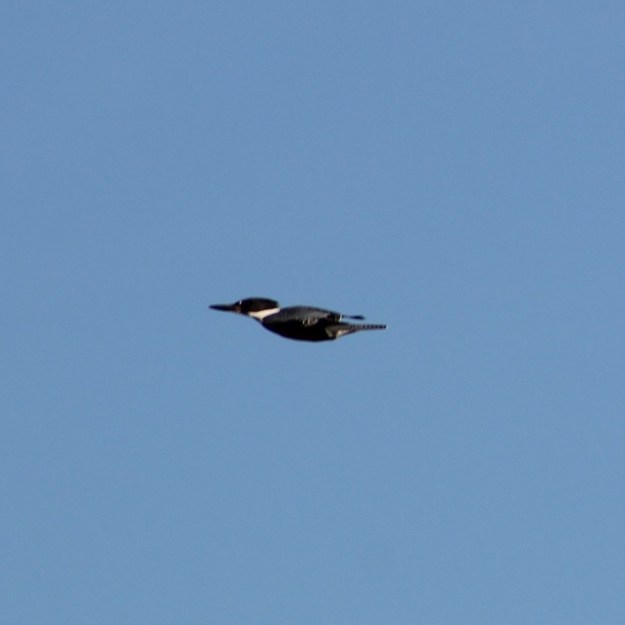
Belted Kingfishers dive at speeds of up to 25 kilometres per hour and can catch fish that are two feet under water.  They can often be heard before they are seen and have a very distinctive chatter.

Kingfisher

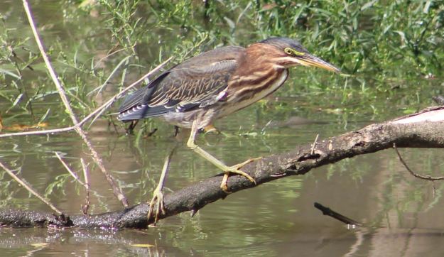
Juvenile Green Heron will usually hunt from shore rather than wading like most members of the heron family.

green

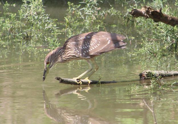
Juvenile Black-Crowned Night Heron are brown in colour with spots on their wings and backs.  They will change colour as they mature to have the distinctive black crown and back with the rest of the body being white.

Black

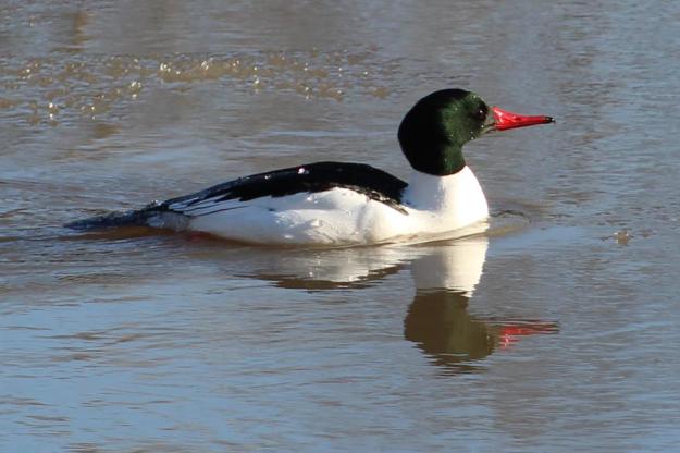
Common Merganser feed on a diet that is primarily made up of fish.  They have serrated edges to their bills which give rise to their other name which is “Sawbills”.

merganser

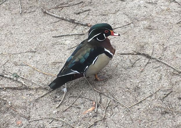
The Wood Duck is one of the most remarkably coloured members of the duck family.  The male has ornate feathers on almost all of their upper body.  Only the chest lacks a pattern.  They are found primarily in wooded ponds where they nest in hollow trees.  Their feet have little claws which makes them the only duck that can cling to bark and branches.

wood duck

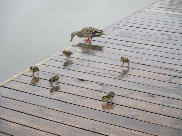
Just like the juvenile Canada Geese we looked at earlier, Mallard Ducklings are also very cute.  Mom jumped of the dock into Lake Aquitaine and one by one the little ones followed her.  While she was quite graceful, they each plopped into the water.

mallard ducklings

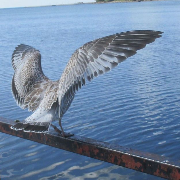
One of the most common waterfront birds is the “seagull” which is a term loosely applied to several different Gull species and often includes Terns as well.  In general these birds are unremarkable, but sometimes you just catch them at the right moment.

gull

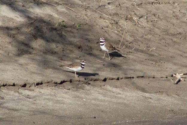
Killdeer have a diet of worms and insects and migrate as far south as Mexico.  They get their name from the sound of their call rather than the number of deer that they kill.  Which is none.

killdeer

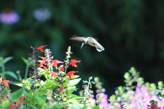
Hummingbirds are the smallest bird that migrates and the only bird that can fly backwards.  Even though they live off of the nectar from flowers they have no sense of smell.  With a weight under two grams they have the ability to dive at speeds approaching 80 km/hr.

hummingbird

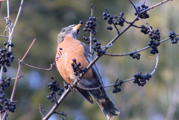
American Robins don’t fly south to escape the cold, they move around to seek food.  Most of them will stay in the area where the temperature is warm enough that they can still get bugs and worms.  The ones who stay behind switch their diet to berries and seeds.  This picture shows a robin with a berry in its mouth.

Robin eating

Leucism causes an animal to lose part of its pigmentation.  This Leucistic Robin was seen two years in a row in the same area.

Leucistic

Obviously, the trail and parks are full of birds and avid birdwatchers will collect dozens of species on their “Life-List” of sightings.  We hope to be able to add to ours soon.

Like us at http://www.facebook.com/hikingthegta

Follow us at http://www.hikingthegta.com

Look for us on Instagram


Used Cars

Sunday, April 19, 2020

The more trails you hike, the more likely you are to come across the remains of an an old vehicle quietly rusting away.  Often they are in places that you could no longer drive a car to because of new growth.  This post features several old cars that we have covered before in some of our earlier posts.  Each of those has a link to the post where there is more information.  Some of them have not been published before and so no links are available.  They are presented in no particular order.

The first ones that we’ll feature are the farthest away, in the Georgian Bay area.  We parked on 13 side road off of the 7th line a little south west of Meaford to go investigate the remains of the Georgian Bay Milling And Power.  The area we accessed as we went down the old road allowance is known as Trout Hollow. As we walked along the road allowance we started to find the remains of old cars.  It’s hard to say how many cars are here because the parts are all mixed up.  There could possibly be five of them, all from the late 1940’s or early 1950’s.  The first pile we found contained the hood of an old Ford truck, a panel with the three trademark vents of a Buick and the side panel of a Cadillac among various other parts.  The Cadillac can be dated to 1947-1952 based on the shape of the logo.

img_0774

Following the yellow side trail where it goes to the right off of the road allowance brings you past one of many 1940’s era cars that have been pushed down the hillside prior to the growth of the current forest cover.  More information on this hike can be found in our post Trout Hollow.

trout-car

Nearly 2 kilometres from Hockley Valley Road on the Bruce Trail are the remains of a 1939 Chevy Sedan that are being slowly disassembled and removed.  The property belonged to Dennis Nevett who owned and farmed it until 1974 when he sold it to the government for the creation of the Hockley Valley Provincial Nature Preserve.  The family used the sedan from about 1951 until 1959 when it died.  Over the next year or two it was towed to the back corner of one of the fields and left to rust away.  The story of this hike can be found at our link Hockley Valley.

img_2103

Just south of Hillsburgh in the first hollow lie the remains of a collapsed house and a car from the late 1940’s or early 1950’s.  More pictures of this area can be found in our Hillsburgh post.

img_0150

Two cars can be found in Streetsville as you make your way upstream toward Hyde Mill. This car is in pretty good shape although it has been stripped clean of every usable part. The trunk lid still contains an old decal showing how to use the tire jack.  From the part number on the decal we were able to identify this car as a 1977 Ford Galaxy 500.  More pictures from this hike can be found in our story Hyde Mill.

img_0249

The remains of an old vehicle, likely a late 1940’s or early 1950’s, lay at the bottom of the hill as you approach Hyde Mill from the river level. This car may have been here for quite a long time as it is damaged beyond identification.  These two vehicles must have been dumped down here before the trees grew up on the embankment above.  The story can be found at the link for Hyde Mill.

img_0232

North of Georgetown there is an old wreck near the Bruce Trail.  We entered on the Eight Line Side Trail and made our way to The Great Esker Side Trail.  Along the way we identified the remains of an old car in the woods.  It has clearly been there for decades as it has no motor and is surrounded by mature trees. It is in a very advanced state of decay.  The front bumpers and grill pattern were quite unique in the various car models of the 1940’s.  Having looked through hundreds of online pictures, positive identification wasn’t possible but the closest candidate was a 1946 Chevy Stylemaster.  More pictures and this story can be found in our post about The Great Esker 

IMG_5128

Between Kerns Road and Guelph Line, along the Bruce Trial, lie the remains of a car with a tree growing out of the rear passenger seat.  Positive identification wasn’t possible because no identifying stickers or plastic parts could be found.  We did notice that the front bumper incorporated the side signals in a unique three cut-out pattern.  Identical looking side markers can be found on the 1970 Chevy Impala.  More pictures of this wreck and the rest of the hike can be found in our story starting at Kerns Road.

img_0080

One of the strangest places is the Toronto side of the Etobicoke Creek, south of the 401.  This section of ravine has at least eight different cars all of which are 40 – 50 years old.  How they all came to be within a kilometre stretch along the one side of the creek is an open mystery which we hope to solve one day.  For now, here are some of the autos in this area.The most prominent one is a 1975 Chevy Vega as identified by the tail light configuration and a specific pattern in the quarter panel.  This car was featured in greater detail in our Etobicoke Creek Trail post.

img_2764

This one appears to have the paint job of a 1979 Ford Bronco.

IMG_2443

There is a small area just south of the 401 where there are three cars in one small area.  When we visited here earlier we wrote about them in a post called The Auto Graveyard.  The car pictured below was identified as a Datsun 1200 coupe by the tail light cluster.

img_3821

Car number two is a Chrysler and it too has seen some better days.  There’s been a few parts removed from the engine but once you replace them you can set the firing order as per the sequence on the casting.

img_3837

The third car in this location was a GM, based on the engine housing.  We can deduce that the model year was likely 1970 or earlier based on the bumper design.  The 5 MPH crash design was imposed in 1971.  This required that an impact at 5 MPH should not damage the lights and so they were removed from the bumpers and placed on the rear panel of the car.  The bumpers were extended from the frame and much of the fancy tail light/bumper design was lost forever.  This rear bumper appears in two parts likely with an extended cluster of tail lights running between them.

img_3851

There are several other skeletons of cars in this area which haven’t been identified because we lacked a unique identifier like a light housing or a part number.  The one in the picture below is a Ford as stamped on the motor housing.  What kind and how old is unknown.

IMG_2153

This car is interesting because the transmission is laid open with all the gears exposed.

IMG_1952

This last one we throw in as a bonus.  It was taken along the Don River on September 14, 2019 but remains unidentified.

IMG_6861

No doubt there are many more abandoned cars scattered throughout the GTA.  Some of which we’ve visited prior to starting this blog and some we have yet to discover.

Like us at http://www.facebook.com/hikingthegta

Follow us at http://www.hikingthegta.com

Look for us on Instagram

Glen Rouge Campground

Sunday, April 12, 2020

In the midst of a global pandemic we are looking through thousands of photographs for opportunities to bring you previously unpublished stories.  This feature story presents  a series of pictures we took in Rouge National Urban Park on December 21, 2019.

Starting in 1923 Jack Graham developed Graham Park on the Rouge River near Kingston Road.  There was space for about 10 campers who paid $40 for the entire season.  There was no electricity and so the park was lit at night by Coleman lanterns.  Water was carried from a natural spring nearby.  Campers were allowed to collect wood for their cooking fires and were even permitted to cut down cedar trees for fire wood.  By 1950 a large pool had been added by damming the river.  The children would sit below the dam and allow the water to cascade over them, pretending it was Niagara Falls.

IMG_8700

In 1952 a new office and Graham Park Restaurant was built where a full meal could be had for $2.90.  Following Hurricane Hazel in 1954 the park was bought by the Toronto Region Conservation Authority who continue to operate the campground.  We decided to visit during the off season to check it out.

IMG_8702

The campground has the advantage of being only about 35 kilometres from downtown Toronto and is easily accessed from the 401.  There isn’t a lot of activities for the children but there are plenty of trails to enjoy.

IMG_8706

The camp sites at Glen Rouge campground have water and electricity provided.  You don’t have to carry water from the spring any more although lighting the campsite with Coleman lanterns may still be the preferred way to relax in the evening.  There are also some sites that are not serviced for those who want a more traditional camping experience.

IMG_8711

A small bag of fire wood has been left in one of the campsites.  No longer are the guests allowed to collect wood from the park.  Today we recognize that the fallen branches and dead trees provide habitat for many insects and small animals.  It is also possible for the larger crowds who can camp here to strip the woods clean in no time.

IMG_8717

Parks Canada operates a few cabin/tent lodgings called oTENTiks in the park.  These 19 x 24 foot tents provide a comfortable camping experience for families and others who don’t want to rough-it in a traditional tent.

IMG_8723

The Rouge River was just starting to freeze over with slush forming and floating downstream.  There is an interesting pattern in the ice in the middle of the river where the slush has piled up.

IMG_8715

With a thin layer of fresh snow it makes it possible to see where the local wild life has been running around.  This set of tracks looks like a small rodent such as a mole or a vole.

IMG_8710

It was four days before Christmas and the park was quiet.  Most of the birds had left for the season and although we saw plenty of deer tracks we didn’t get to watch any of them.

IMG_8707


The campground was scheduled to be closed for the 2020 season to allow underground improvements to water and sewage management.  This is perhaps the first time it has had a period of rest for almost 100 years.  I think the wild life is going to be very happy this spring.

Other hikes in Rouge National Urban Park include:

The Mast Trail

Beare Hill Park

Vista Trail

Maxwell’s Mill

Google Maps Link: Glen Rouge Campground

Like us at http://www.facebook.com/hikingthegta

Follow us at http://www.hikingthegta.com

Also look for us on Instagram


Hurricane Hazel – Raymore Drive

Sunday, April 5, 2020

With restrictions in place that are intended to prevent the spread of COVID-19, Hiking the GTA is looking into our collection of unpublished pictures to see what new stories we can bring you.  We hope to keep ourselves entertained, and perhaps you as well, while we wait for the parks and trails to be opened up for us again. 

These pictures were taken on September 19, 2019 with the idea of a possible post about the destruction caused by Hurricane Hazel in the area of Raymore Drive.  We had previously featured some information in our post Raymore Drive and so we won’t cover all that material again.  As we walked along the Humber River on a beautiful Saturday in September we stopped to watch the ducks and admire one that was a little different.  It may be just a variegated mallard as it doesn’t seem to match any duck in the National Geographic bird book.

img_1894

The picture below shows Raymore Drive in Etobicoke in 1953, about a year before Hurricane Hazel struck.  When the hurricane paused over the GTA on October 15, 1954 it dumped so much rain that the rivers all flooded their banks and 81 people were killed.  Notice the pedestrian bridge that crossed the Humber River and the two streets of houses that were tucked into the curve of the river.

Raymore 1953

When the water levels rose on the river the bridge was swept off of the west abutment and began to deflect the flow of the river into the housing development.  With the full flow of the river rising by 20 feet there were 14 homes washed away and 35 people lost their lives in this small enclave.  In the 1956 picture the bridge is gone and so are the houses on the two streets closest to the river.

raymore 1956

The east bank of the river still has the remains of the bridge abutment and, as a memorial, it has been plastered with replicas of the news papers that came out following the storm.

img_1895

There is a set of concrete walls that surrounded the old bridge abutments.  Just for fun I walked through the grasses and shrubs that surrounded the old structure.  That was a big mistake because I ended up with hundreds of little seed pods stuck to my clothes that had to be picked off one-by-one.

The whole structure has been overgrown during the past 65 years and it is difficult to imagine exactly what it may have looked like when it was in use.

This willow tree will eventually push over this section of the wall as nature slowly reclaims its own space.

img_1899

Some parts of the old bridge foundations have been washed into the river where they now provide some shelter and habitat for the blacknose dace that live in the river.

A new pedestrian bridge has been built across the river to link two sections of the Humber River Trail.

A large section of the west abutment can be seen in the river where pieces of wood and tree branches have been washed onto the top by high water and then left stranded there.

The former residential streets have been retained and are now in use as the main hiking trails through Raymore Park.  Many of the homes in the various flood plains around the city were washed away or damaged beyond repair.  In the aftermath of the hurricane it was decided that no homes would be allowed on the flood plains of any watercourse in the GTA.  Homes that survived Hazel were bought up by local conservation authorities and soon demolished.  This led to the creation of many of the ravine trails and parkland that we enjoy in the city today.

The Old Albion Road bridge across the Humber River was destroyed on the night of October 15, 1954 along with another 40 bridges in the GTA.  A short piece of the former road allowance and the old cut stone blocks of the east bank abutment mark one side of the old road alignment.  On the west bank of the river all traces of the former road have been removed.

img_2569

Over on The Rouge River the storm washed the Old Finch Avenue bridge away and shifted the abutment so that the new bridge appears to be on a new alignment.

img_88491

It’s tragic to think of the destruction that nature can cause but there have been several steps take to reduce the risk in the future.  Flood control dams were built on each of the three main rivers.  Milne Dam on the Rouge River, G. Ross Lord Dam on the Don River and Claireville Dam on the Humber River.

Google Maps Link: Raymore Drive

Like us at http://www.facebook.com/hikingthegta

Follow us at http://www.hikingthegta.com

Look for us on Instagram