Monthly Archives: October 2017

Mackenzie House

Sunday, October 22, 2017

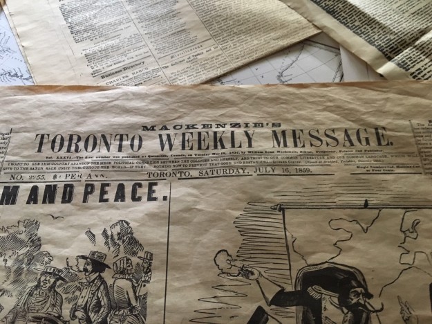
William Lyon Mackenzie was a politician, publisher and rebel who became the first mayor of Toronto when the city was incorporated in 1834.  He had already been publishing his controversial Reform newspaper, The Colonial Advocate, for ten years at this time.  Frustrated, he concluded that the political process had failed him and so in December 1837, he led a rebellion to overthrow Upper Canada’s colonial rule, locally known as the Family Compact.  The rebellion failed and Lieutenant Governor Sir Francis Bond Head placed a one thousand pound price on Mackenzie’s head.  William took his family and fled to the United States where he lived in exile until 1850.  Mackenzie was re-elected to the Legislature in 1851 where he served until 1858 when he retired from politics, but not from controversy or publishing.  His paper was then known as Mackenzie’s Toronto Weekly Message.  The picture below shows the July 16, 1859, issue.

IMG_0119

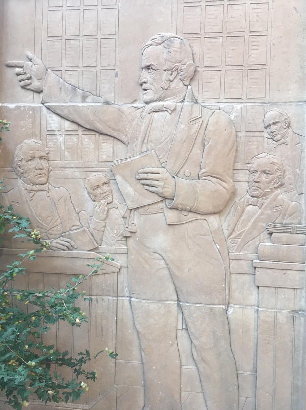
The picture below shows a carving of Mackenzie delivering his famous Seventh Report on Grievances to the Assembly.  This was his manifesto of all the changes he was demanding of the government.  It included three levels of government, all elected by the people, the abolishing of a state church and clergy reserves as well as giving the vote to women.

IMG_0098

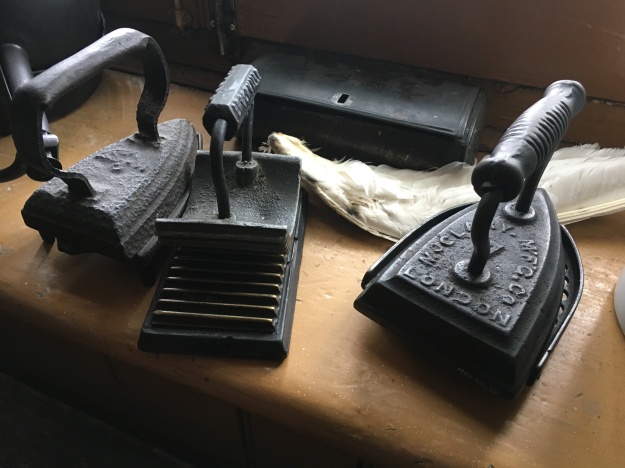
Mackenzie House, seen in the cover photo was built in 1858 as the middle of three such townhomes.  It was given to Mackenzie in 1859 and he lived here until he died in 1861. The house has been serving as a museum since 1950 and has been decorated in the time period of the 1850’s to reflect what it would have been like when Mackenzie lived here.  Adults pay an entrance fee of $7.00 and more information can be found on their website.  The irons below are typical laundry tools of the period.  They were heated in the fire and then used to press the clothes after they had been hung to dry.

IMG_0113

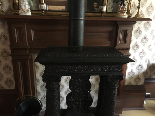
In the winter the family would have spent much of its time in the basement as this was the warmest part of the house.  Both the kitchen and the dayroom had fireplaces in them and, naturally, only the rooms in use would have been heated.

IMG_0122

The master bedroom faces Bond Street and, unlike Colborne Lodge (built in the rebellion year of 1837), it had its own fireplace in the bedrooms.  Colborne Lodge, on the other hand, had an indoor washroom and so there was no need for the chamber pot under the bed, seen below.  There would have been an outhouse in the backyard of the Mackenzie house, likely about where the printing shop is located now.

IMG_0134

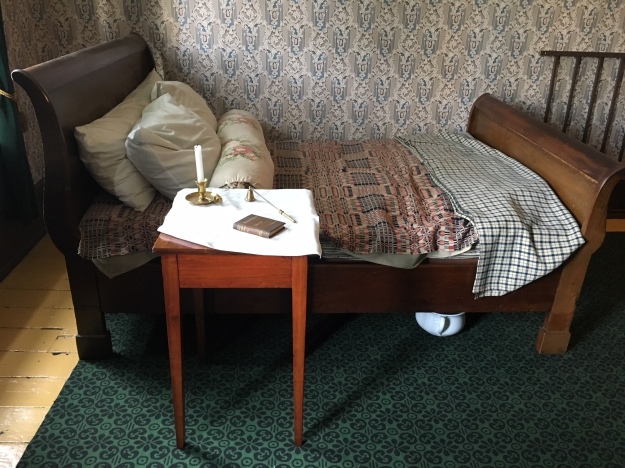
The house was built in an era when insulation was unheard of, with the possible exception of old newspapers stuffed in the walls.  Winter nights would have been very cold and the bed was heated up before you dared to slip into it.  The copper coloured pan on the long handle was warmed in the fire and slid between the sheets just before you crawled into bed.

IMG_0132

The second floor has two bedrooms and a box room which would have been used to store hat boxes and boxes of William’s printed materials and newspaper clippings.  This room had no fireplace but was likely used as a bedroom when their son George was living here.  The girls shared the bedroom at the back of the house, pictured below.  One of their daughters, Isabel, lived in this room until she married into the King family.  Her son William Lyon Mackenzie King was Canada’s longest serving Prime Minister.  His actions during World War Two helped move Canada out of the shadow of Great Britain, something his grandfather was trying to do with his rebellion.

IMG_0128

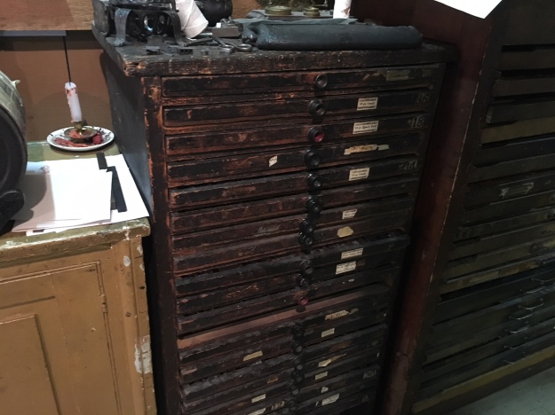
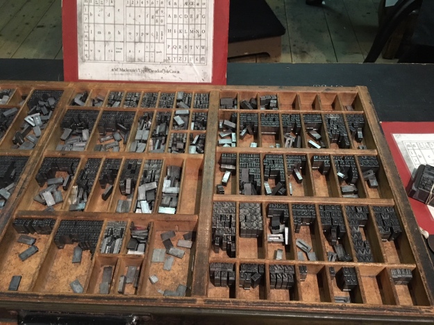
One of the antiques in the print shop is known to have belonged to William and that is this case of printing type.  On June 8th, 1826 a group of young men who represented the Family Compact broke into Mackenzie’s print shop and smashed his printing press.  They took his cases of type and carted them down to the bay where they summarily deposited them.  This attempt to silence the constant criticism of the government that was printed in The Colonial Advocate became known as the Type Riots.  Mackenzie used this incident as a focal point to create anger over the abuses of those in power as he gathered support for his rebellion.

IMG_0141

Mackenzie didn’t usually set his own type, one of his apprentices would have done that.  The type that was used on his early newspapers was made from lead and print journeymen tended to have a very short lifespan due to lead poisoning.  The letters were laid out in the case so that letters that occur frequently beside each other are placed together in the tray.  Originally, capital letters were stored in the upper case and small letters were kept in the lower case.  From this practice, we derive the terms upper and lower case letters.  A good typesetter would be capable of 22 words per minute.

IMG_0138

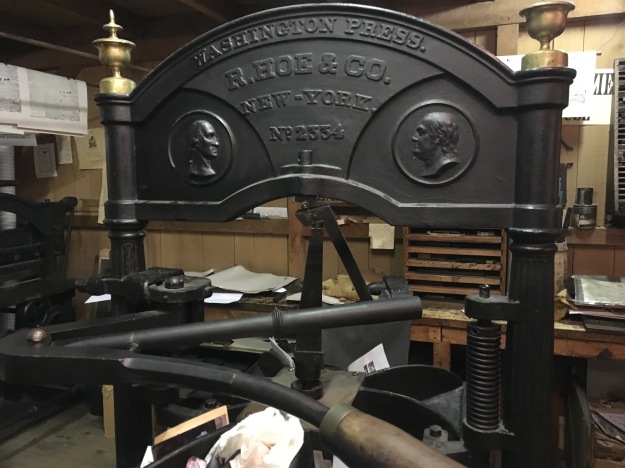
This press is similar to the one that Mackenzie would have used during the later years of publishing.

IMG_0139

Mackenzie House is open 7 days a week as a museum and if you take the print shop tour you can operate the printing press yourself.

Google Maps Link: Mackenzie House

Like us at http://www.facebook.com/hikingthegta

Follow us at http://www.hikingthegta.com

Humber Grove – Ghost Towns of the GTA

Saturday, October 21, 2017

The remains of a ghost town lie along the Humber River on Duffy’s Lane just north of Bolton.  The property of George Elliot on the county atlas below was in the Elliot family from 1855 until 1929.  During this time a few homes were built along Duffy’s Lane with views of the river.  Only two are shown at the time the atlas was drawn in 1877.  By 1909 there were half a dozen homes with a small community forming around the bridge over the river.  In 1929 the 100-acre half lot was sold to Bertram Realty Company who planned to capitalize on the quiet setting along the river.  They divided the land into small parcels and started selling them for cottages.  People began to buy the lots and build on them and by the early 1950’s there were enough children to support the construction of a new school at the corner of King Road and Duffy’s Lane.

In October 1954 Hurricane Hazel hit the GTA killing 81 people and changing the way we managed our floodplains.  Local conservation authorities across the GTA began to buy properties and remove houses that were considered at risk.  They also developed a plan that called for the construction of 15 major flood control dams and reservoirs including one on the Humber River just north of Bolton.  Of these dams only Claireville, G Ross Lord and Milne Dam were constructed.  The Glasgow dam would have been 29 metres high and Humber Grove would have been under the new flood control lake.  Slowly the houses were moved or demolished until by 1977 there were no buildings remaining.

humber Grove (2)

Duffy’s Lane is exactly that, their original laneway.  This is what is known as a “given road” because it is not part of the original grid of the township survey.  It is a privately constructed road, on private land, that was given for the use of the public.  For reference, Duffy’s Lane has been coloured brown on the map above.  The Duffy house was built in the 1840’s and has been given a historical designation by the township of Caledon.  It is seen in the picture below and marked with a red arrow on the map above.

IMG_1606

Duffy’s Lane has had many alignments in the area where Humber Grove was and there have been at least four bridges over the river.  The county atlas above shows a bridge over the west branch of the Humber River that predated the use of poured concrete for bridge construction by 20 to 30 years.  Therefore, the abandoned bridge in the cover photo has to be at least the second bridge at this location.  The picture below shows the abutment for the old bridge in the lower right corner.  This bridge was likely built at the time that a subdivision plan was put forward in the 1920’s.  A new bridge would have been helpful in persuading people to buy a lot this far outside of Bolton. On the left in this picture are two newer bridges, the lower one from 1985.  In 2013 work began on the Emil Kolb Parkway as a bypass to keep the increasing flow of traffic from going through downtown Bolton.  The new multi-lane bridge was built in 2014 and the older one converted to a pedestrian trail.  It is likely that some of the original Humber Grove foundations were lost during the construction of these various bridges.

IMG_1573

Milkweed pods have started to break open exposing their seeds to the wind.  Each tiny, flat seed is carried on the breeze by hundreds of tiny filaments attached to it.

2432


Milkweed is essential in the lifecycle of the monarch butterfly.  There were many of these orange beauties flying around and it seems like it is late in the year for them.  This is the fourth generation of monarch born in Ontario this year and it is programmed to fly to Mexico to spend the winter.  The example in the picture below is a female because it lacks the two little black dots on the hind wings that mark the male scent glands.

IMG_0071 (1)

Throughout the woods, there are several obvious laneways, most often marked with a double row of trees that lined either side of the old roads.  In a couple of places, there are old hydro poles in the woods that have the wires cut from them because the homes they once served no longer exist.

IMG_1586

At the end of the laneway above is an obvious clearing where a house once stood.  The back end of the property has been reinforced with a concrete wall.

IMG_1587

A garter snake was sitting on a fallen branch taking in the late October sunshine.  These snakes don’t actually hibernate unless they are in a climate where it goes below -40 Celcius.  In reptiles, hibernation is normally referred to as brumation.  In most cases, the garter snake is awake through the winter with a 77% reduced heart rate and minimal oxygen intake.

IMG_0078

The original alignment of Duffy’s Lane can still be found running north from the earlier bridge abutments at the river.  Former laneways extend into the woods along the sides of the road.  We found an old concrete foundation a few feet into the first of these laneways.  The woods have been regenerating for 40 years and most of the former entrances can only be made out due to the parallel rows of mature trees that line either side.

IMG_1599

Old fence lines mark the edges of the various properties that used to line both sides of old Duffy’s Lane.

IMG_0075

The boletus family of mushrooms includes over 100 varieties, many of which are edible.  They can be distinguished by the tubes that carry the spores under the cap rather than the gills that can be found on many other types of mushrooms.  Make sure that you never touch or eat any mushroom that you cannot positively identify.  There are often similar looking species where some are edible and some are poisonous and can kill you.

IMG_0068

There is a lot of tall grass, dog-strangling vines and undergrowth throughout the area. There are plenty of foundations remaining to be found, perhaps when there is less foliage.  Humber Grove can be accessed from the Humber Valley Heritage Trail.  We explored part of this trail in a previous post called Humber Heritage Trail Bolton.

The Toronto Region Conservation Authority has an informative article on Humber Grove with historic maps that can be found here.

Google Maps Link: Humber Grove

Like us at http://www.facebook.com/hikingthegta

Follow us at http://www.hikingthegta.com


Bronte Creek at the QEW

Saturday, October 14, 2017

Legends of Devil’s Cave abound, including one that claims that William Lyon MacKenzie hid in the cave when his rebellion fell apart in 1837.  The cave is said to have an artesian well inside that creates a pool known as the Devil’s Pool.  It is located along Bronte Creek just north of the QEW.  The QEW and Bronte Road is the site of the former community of Merton  The last of the buildings for the town, including the 1857 school were removed to make way for the highway.  The Devil’s Cave has been closed and is not easily accessible but we decided to try and find it along with having a general exploration of the area looking for any evidence of the former community.  To start, we decided to try and make our way along Bronte Creek from a free parking lot in Petro Canada Park.

Mike “Prime Time” Post was an Oakville native and lightweight boxer.  Mike had a promising career when, tragically, he was found dead at the age of 28.  A memorial was erected in 2009 on the one-year anniversary of his untimely death.  It stands at the entrance to Petro Canada Park where Mike used to practice by running up and down the hill.

IMG_1519

The Green Heron is one of the least common of all the heron species we have in Southern Ontario as we are near the northern extreme of its habitat.  It is small and stands at just 17 inches.  The neck is short and usually held tight against the body.

IMG_1466

Black walnuts grow along the trail and are starting to drop off the trees.  These walnuts can be eaten and are grown for food.  The hull can be used for medicine to treat such ailments as syphilis and diphtheria.

IMG_1494

We crossed the tracks to see if there was a better way access to the bottom but found that the best place was right beside the bridge abutment where large boulders had been placed and we were able to climb down.  Notice how the bridge has been expanded with the original section being made of cut limestone blocks while the newer part is made of poured concrete.  The original line was known as the Hamilton and Toronto Branch of the Great Western Railway and was opened to traffic on December 3, 1855.

IMG_1495

Once at the bottom, we had to skirt around a small section of shale cliff but there is lots of room along the bottom with the water level in the creek being low.  You can make your way along the creek for some distance and today there was several dead salmon that had been left on the edge of the stream.  It is impossible to make it past this cliff of red shale and so continuing upstream at water level is not an option.  Notice the fisherman in the distance as it gives the photo a means of perspective.  This is a very long, high shale cliff.

IMG_1513

We circled back and made our way to the top of the shale cliff and from there back out to Bronte Road which we followed back to the car.

IMG_1516

We moved the car to the Car Pool parking near the QEW bridge.  From here we began to make our way upstream again.  This section of the creek flows through Bronte Creek Provincial Park with its very own haunted house.

IMG_1527

There is a long section where there is a manmade berm running parallel to the embankment.  This very likely was a raceway leading to a mill in Merton.  The berm can be seen in the photo below where an animal trail runs along the top.  Trees grow on the top and sides of the berm where the ground is less marshy.

IMG_1533

Bronte Creek was full of fishermen and we saw one person take a nice size salmon home.  It was hard to find occasions when you could get a picture without people knee deep in the river.

IMG_1534

We followed animal trails along the side of the ravine trying to stay above the parts where water is seeping out of the side of the embankment.  The lower floodplain is a swamp throughout this area.  The side of the hill has a lot of loose leaves and topsoil on it and is very unstable.  Eventually, we determined that we needed to make our way to the top of the hill.  This landed us in someone’s backyard and so it was time to make a quick exit to Bronte Road before we found ourselves face to face with the owner.  Along the pathway, we came across this carving of an owl.

IMG_1536

Returning to the car we followed the old Bronte Road that runs under the highway.  Prior to 2008 this was a 3 lane road, it now serves as a pedestrian and cyclist path that leads back to the Carpool parking lot.

IMG_1537

Near the bridge, a small patch of milkweed stands with the seed pods almost ready to burst open and spread their seeds to the wind.  The pods are known as follicie and the seeds each have white filaments on them called coma.  These are hollow and make good insulation.  Due to this, milkweeds are also grown commercially for use as stuffing in hypoallergenic pillows.

IMG_1540

We didn’t find the cave and discovered that this is not a hike that is safe for everyone.  Also, you may eventually be forced out onto private property so beware.  The cave is out there, waiting for us to come and find it some other day.

Google Maps Link: Petro Canada Park

Like us at http://www.facebook.com/hikingthegta

Follow us at http://www.hikingthegta.com

Abandoned DVP Ramp

Saturday, October 7, 2017

The most popular new post so far in 2017 has been a collection entitled “Toronto’s Abandoned Roads“.  It contains links to a dozen posts about sections of road in Toronto that have been closed for various lengths of time but can still be identified and explored.  There is a closed ramp to the Don Valley Parkway (DVP) that has been on my “to do” list for a long time.  You can’t park on York Mills but it is only a short walk from Lochinvar, where you can park for free.  The Google Maps picture below shows the remains of the ramp as it appeared in 2016.

DVP ramp

When the DVP was built the 1960’s the ramp was opened in a partial cloverleaf that did not include the northeast corner.  As the highway got busier the ramp in the northwest quadrant became the site of an increasing number of accidents.  Westbound traffic on York Mills entered the highway into the southbound lanes in close proximity to the exit ramp for southbound motorists who wanted to get off the DVP.  Cars slowing down right where others were trying to get up to highway speed proved to be a bad combination.  In 2005 it was decided to close the ramp and the section along the side of York Mills Road was removed and replaced with landscaping that hides the fact that there is an old ramp just out of sight.

IMG_1417

The old road surface is already showing the signs of neglect.   The picture below shows the end of the pavement near York Mills.  There are trees growing through cracks in the pavement.

IMG_1454

When the ramp was in use a ring of maple trees circled the inside of the ramp.  Today the area inside the ramp has been taken over by first-generation regrowth.  There has been some planting of white oak trees and other native trees and shrubs and now the open grass field has been transformed into a little oasis just metres away from the rush of the DVP.

IMG_1429

The afternoon had turned warm at 19 degrees with only a slight breeze and I was pleasantly surprised to hear the call of cicadas in the trees.  I saw this large cottontail rabbit that paused to get his picture taken.  Cottontail rabbits are seldom seen on windy days because the wind interferes with their hearing which is their primary defence against predators.

IMG_1443

An old sign prohibiting stopping can be seen beside what once served as a pedestrian walkway alongside the ramp.

IMG_1450

A little farther along the old road, I came to a small trail leading into the trees along the side of the ramp.  The entrance to the trail was marked with a large amount of coyote scat which gave me a pretty good idea of what the rabbit had been listening for.

IMG_1452

In the days before this sound barrier was constructed cars entered the DVP at this point.

IMG_1438

This Google Earth shot was captured in 2002 at which time the ramp was still in use.  A car can be seen as it approaches the curve at the top of the ramp.

DVP ramp

We have investigated several other closed sections of road, some of which have been out of service for many years.  It was good to see how much had been reclaimed in just twelve years to get a perspective on how fast nature moves back in.

Google Maps Link:  DVP and York Mills

Like us at http://www.facebookcom/hikingthegta

Follow us at http://www.hikingthegta.com