Monthly Archives: August 2018

Baneberry

Monday, August 27, 2018

While exploring Altona Forest we found two different types of Baneberry plants growing within a few feet of each other.  The White Baneberry  or White Cohosh is also known as Dolls Eyes because of the black stigma scar on the end of the berry.  The entire plant is considered toxic to humans.  Ingestion of as few as six berries can cause cardiac arrest and death in an adult.  A child may not survive after eating as little as two berries.  Birds can eat the berries and disperse the seeds through their droppings.

3907

The Red Banberry has a much thinner pedicel or stem on which the berries grow.  The berries start off green but turn red when they ripen.  Each berry contains several seeds.  The Red Baneberry plant and berries are poisonous as well.  A member of the Baneberry family that has been used for medicinal purposes for centuries is Black Cohosh which has been used to treat women’s gynecological disorders.

3909

Watch for more on Altona Forest in a future post.

Google Maps Link: Altona Forest

Like us at http://www.facebook.com/hikingthegta

Follow us at http://www.hikingthegta.com


The Bruce Trail – Limehouse

Saturday, August 11, 2018

The Bruce Trail has many side trails which form little loops along the way, especially in The Toronto Section where side trails account for 60 kilometres compared to only 50 kilometres of main trail.  This makes for a nice change of scenery if you are doing a one car, return hike.  We set out to hike from the parking place on the Sixth Line, north of 22nd Side Road, into Limehouse and back doing the Ridge Side Trail and Todd Bardes Meadowland Side Trail along the way.  A severe limitation to the Bruce Trail App in combination with my iPhone is the extreme drain on the battery.  I was forced to switch it off after only 8 kilometres because the battery was down to 1%.   I have since learned that using airplane mode and low power can help resolve this if I want to map hikes for the sake of a blog.

Limehouse Trail

The trail starts off along a beautiful boardwalk through the woods which were surprisingly free of mosquitoes on this morning.  There was also a stillness to the woods as the birds were quiet.  The trail leads almost directly from the sixth line to the fifth where you are forced onto the road for half kilometre or so.

IMG_6027

Hemlock Varnish Shelf is growing along this fallen tree.  This fungus starts off as a small red nub on the side of the tree and grows into the familiar conk shape.  When it is young it has a brighter red colour and a varnished look to it.  The outer edges will be yellow or white but as it ages over the summer it changes to a more even rusty colour extending to the edges.  These fungi are known as polypores because they have multiple small tubes or pores on the underside of the fruit body that release the spores.  This group of fungi is key to the breaking down of wood and are key in the nutrient cycle of the forest.  Polypores are often used in traditional medicine and science is studying the Hemlock Varnish Shelf for potential uses in cancer therapy.

IMG_6046

As this hike progressed it became obvious that there was an extremely large variety of mushrooms growing along the trail.  Every time we hike there is always something interesting and unique about the area we’ve selected.  This time it turned out be the fascinating colours and forms of the fungi we encountered.  Giant puffballs grow along the trail in several places and are one of the prized edible mushrooms.  They grow from August to September and can grow to 20 inches or bigger.  They can be pan fried or battered and fried in slices.  The spores form inside the mature ball and are released in a “puff” when the skin cracks at maturity.

IMG_6065

As the puff balls mature they turn yellow and the skin cracks to release the spores.  The inside turns from white to grey or dark yellow of the puffball spores.  It has been estimated that an average size puff ball can contain up to 7 trillion spores.

IMG_6063

Oyster Mushrooms are considered to be one of the choice edible ones.  They need to be collected when they are young before the flesh becomes tough and woody.  Many Asian cultures use them extensively in cooking and they are cultivated in parts of India.

IMG_6042

There were several places where Scarlet Fading Waxy Cap mushrooms were growing.  As this mushroom matures the scarlet fades to orange or yellow.  The cap is deeply convex with an incurved margin.  It is one of the edible mushrooms however it is reported to be flavourless so it may be best used in a soup or chili.

IMG_6043

Several types of artificial bee habitats have been set up in places along the trail.  These ones are known as mason bee tubes.  This type of bee habitat can be a fun home project to make as a way to encourage the survival of the honey bee.

IMG_6066

The bees still seem to prefer their own handy work in building their nests but the similarities to the mason tubes is interesting.

IMG_6291

A good example of a mushroom that may be edible or may be a poisonous one is seen below.  If this is a Jack O-Lantern it is poisonous but because it is growing singular instead of in a cluster it is likely a Chanterelle which is edible.  Either way, the gills under the cap make this an interesting looking mushroom.

IMG_6033

The Yellowish-White Melanoleuca is also an edible mushroom but there is a very similar mushroom that is poisonous.  The Entoloma species look almost identical but have very different spores that allow them to be distinguished.  Due to the fact that so many mushrooms have look-a-likes that are poisonous you should either be very sure of your identification or leave the plant alone.

IMG_6035

Having reached Limehouse, where a large collection of 19th century lime kilns are preserved we made our way back to the car.

Google Maps Link: Bruce Trail Limehouse

Like us at http://www.facebook.com/hikingthegta

Follow us at http://www.hikingthegta.com

Ireland Park

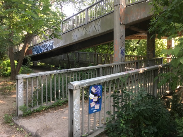
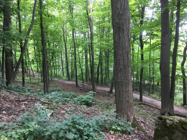
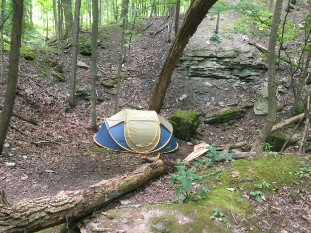
Sunday, August 19, 2018

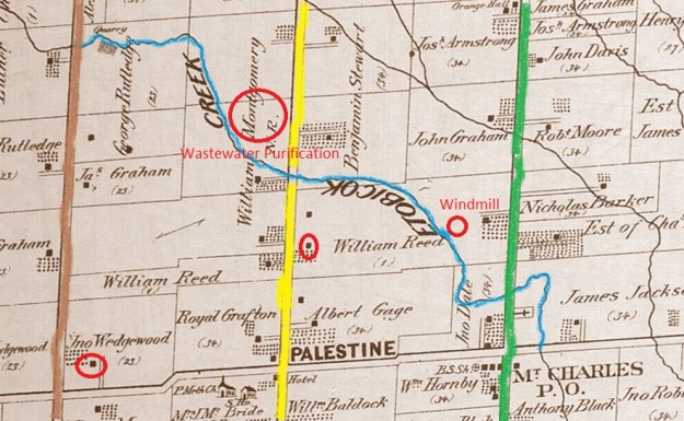
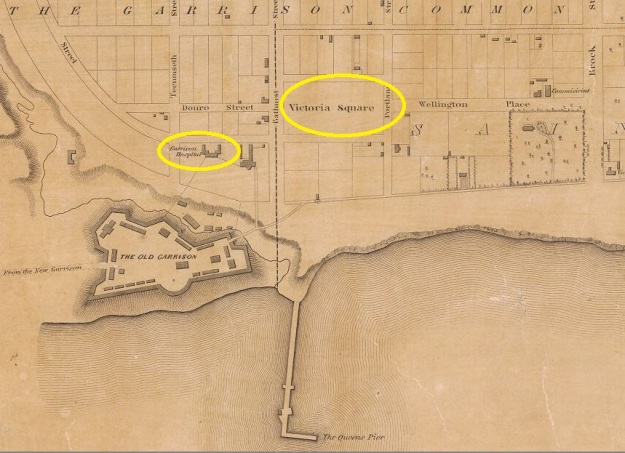
Between 1845 and 1849 the Irish Potato Famine claimed 1,000,000 to 1,500,000 lives and caused a mass emigration from the country.  Many of the refugees came to Montreal and Toronto seeking free land and a chance to provide for their families.  Arriving in Toronto the ships docked at The Queen’s Pier (also known as Queen’s Wharf and today Bathurst Quay).  This was the third wharf in the city built by the military and it stood near the mouth of Garrison Creek at Fort York.  The wharf was buried in 1917 as part of a large in-filling project and is today remembered by Queen’s Wharf Road which runs where it used to extend into the lake.  The 1842 map below shows the wharf at the foot of Bathurst Street with the Garrison Hospital and the military cemetery, Victoria Square both circled.  This is what the city would have looked like when the refugees arrived.

Queen's Pier

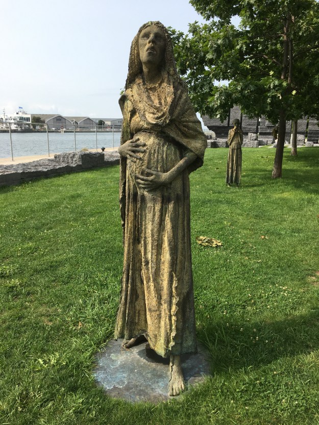
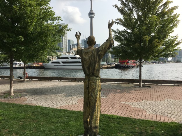
The idea for Ireland Park started when 7 statues were placed near the dockside in Dublin, Ireland in 1997. This was the 150th anniversary of the famine.  The Toronto park opened ten years later on June 21, 2007 with the president of Ireland doing the honours.  The Irish sculpture is known as Departure while the Toronto one is called Arrival.  The seven statues in Ireland have been reduced to five in Toronto signifying the horrible loss of life that occurred.  The first statue is a triumphant man who stands with his arms raised in thankfulness as he surveys the city of Toronto across the water.  In 1847 there were only 20,000 people in Toronto but they will handle 38,560 refugees, many of whom will pass through the hospital to the graveyard.

IMG_6241

A second statue is of a pregnant lady who stands looking up and clutching her belly.  She faces a new life in a new land with a new life inside her.  Like the others, she looks like she has worn the same clothes for the entire journey and that they may not have been the best to start.

IMG_6242

The little boy that stands to the rear of the woman appears to be unsure of what the future holds as he timidly clutches his hands before himself.  He may represent those children who arrive alone, having lost their family either on the journey or shortly after arriving.

IMG_6247

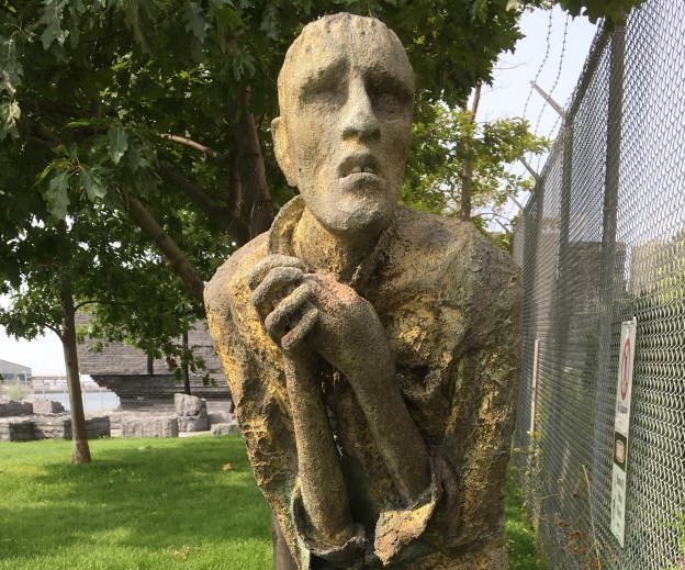
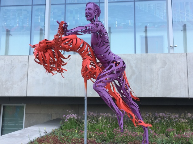
This individual is known as Pius Mulvey and was inspired by a character in the book Star of the Sea by Joseph O’Connor.

IMG_6243

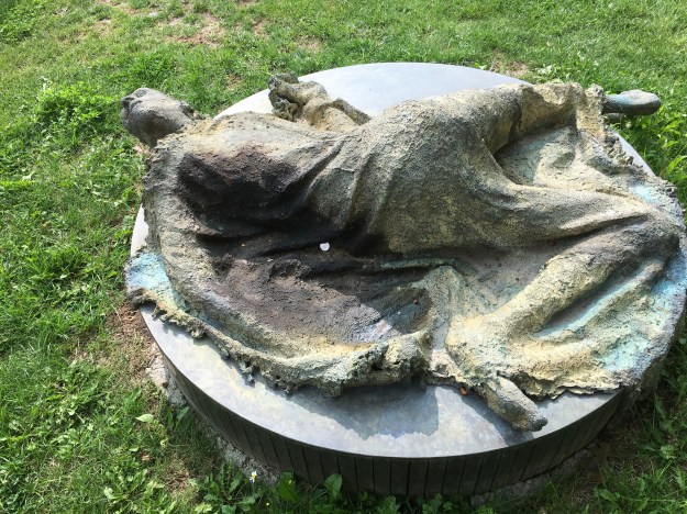
The fifth sculpture depicts a woman lying on the ground.  She is in the last moments of life and represents the hope that was never realized for so many.  Seven departed, five arrived and only four survived to become part of the fabric of the city.

IMG_6245

The emigrants that fled from Ireland in 1847 were packed into crowded ships with poor hygiene for weeks during the passage.  The result was an outbreak of typhus on the ships with so many dying on board that they became known as coffin ships.  Upon arrival, the sick were taken to the Garrison Hospital.  When this facility was full they were put into fever sheds.  Within weeks of arriving 1186 of them had died and some were taken to the burial grounds at Victoria Square.  The limestone for the wall pictured below was quarried in Kilkenny, Ireland and stands in the park as a tribute to the people who perished after they arrived in Toronto.

IMG_6255

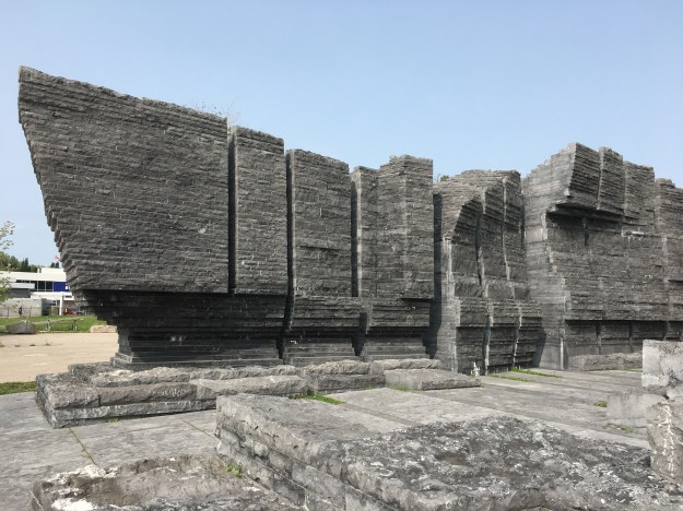
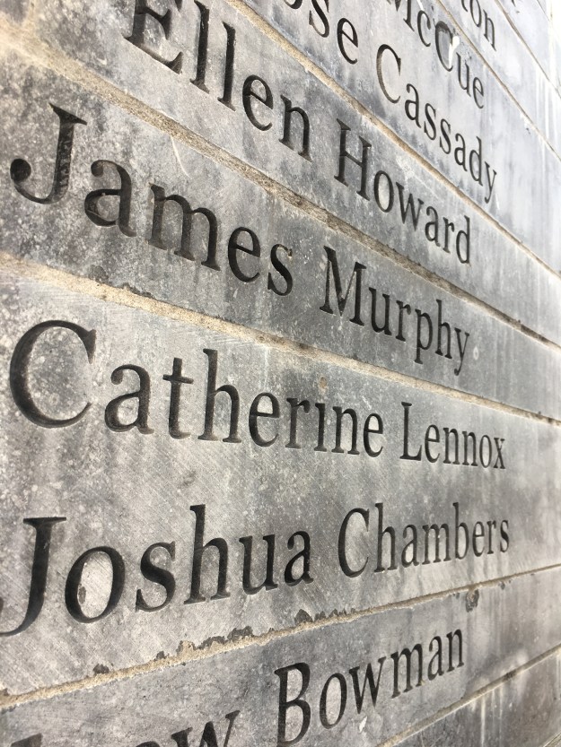
So far, the names of 675 of the people who died upon arrival have been recovered and engraved on the walls.  The names can be found in the narrow slots between the stones.

IMG_6261

The tower of glass bricks represents hope and is lit up at night.  The spaces between the sections of limestone wall where the names are carved are also lit at night to illuminate the names.  After dark, spotlights on the statues cast eerie shadows onto the abandoned silos behind. The silos represent storage facilities for grain during abundant times and stand in contrast to the poverty that the refugees were fleeing from.

IMG_6258

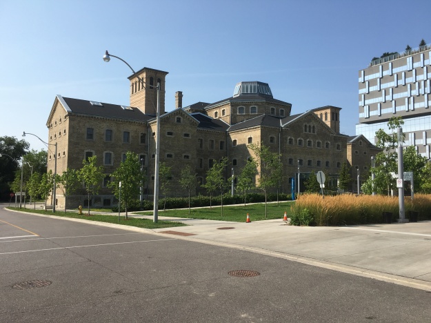
The Canada Malting Company located a set of concrete silos at the foot of Bathurst Street in 1928.  The waterfront had been used for heavy industry for decades and at one time Polson’s Shipbuilding Yards were located here.  Polson’s Pier in The Port Lands is named after this enterprise.  Storage silos had disappeared from the city because they were made of wood and had a lifespan of about ten years due to the fact that they were severe fire hazards.  The Canada Malting Company used concrete silos to store barley in before it was turned into malt.  The original silos near the lake were 120 feet tall and more storage was added in 1944 in the form of 150-foot tall silos.

IMG_6262

The malt was sold for beer and other uses and the operation continued until 1987 when it was closed.  The city has spent the last 25 years looking for a good way to re-purpose the silos as they have a heritage designation being one of the last two remaining on the waterfront.  Some of the silos have been demolished and the remaining ones are crumbling badly but suggestions for their preservation include turning them into a luxury hotel.  It has also been suggested that they may make a good hotel for the dead in a mausoleum with room for 6,500 coffins and niches for an additional 5,000 urns.

IMG_6271

This immigrant statue surveys the skyline of Toronto and raises his arms at the prospects before him.  It would have looked considerably different in 1847 without the towers crowding out the shoreline.

IMG_6246

Ireland Park is a very small location with a very big story to tell and because it is hidden there was no one here during my visit making it perfect for contemplation of this chapter in our history.  It also looks like an interesting place for an evening visit to see the lighting.

Google maps link: Ireland Park

Like us at http://www.facebook.com/hikingthegta

Follow us at http://www.hikingthegta.com

Riverdale Park

Sunday, August 6, 2018

One of the first settlers in York (Toronto) was John Scadding.  He worked as secretary to Upper Canada’s first Lieutenant Governor, John Graves Simcoe.  In 1794 he built a log cabin on his estate as a first home.  In 1856 the city purchased the Scadding homestead for use as a park and to give the city a place to build a new jail.  Thankfully, the early settlers of Toronto preserved some history for us and his home was moved to the CNE in 1879 to make way for the park.  I parked on Carlton Street near Riverdale Farm and went down the stairs into Riverdale Park West.  On my return trip I walked through Riverdale Farm which is also a great place to visit.

Riverdale

Originally, Riverdale Park was 120 acres but it was later expanded to 162 acres.  When the Don Valley Parkway was built it split the park in two and reduced the size to the current 104 acres.  The two halves of the park are joined by a pedestrian bridge that gives access to the Lower Don Trail which leads north toward The Bloor Viaduct.  The eastern part of the park is smaller and retains the distinct shape of the old riverbed as can be seen in the picture below.

IMG_5859

In the 1880’s the lower portion of The Don River, the Don Narrows, was straightened out and a couple of sections were cut off from the river.  These sections of the former river now form the ponds in Riverdale Farm.

IMG_5927

The east half of Riverale Park was used as a landfill in the 1920’s and exhaust pipes still line the sides of the park where methane gas is allowed to escape from below.  Along with a sports track there is a swimming pool on the east side of the park.  The north end has been naturalized again and there are many mature trees along the various hiking trails.

IMG_5864

The Task Force To Bring Back The Don has been working on various projects in the park including several tree planting sessions.  The first one on the eastern slopes was actually the first action in the 40 Steps to a New Don River program.  They have also created a small wetland at the base of the ravine where the runoff from the embankment is collected and bulrushes now grow.  Maximilian Sunflowers are growing in a large cluster at an intersection of trails in the woodlot.  They are not native plants and this cluster was likely planted here.  They are often found in the wild as escaped garden plants.

IMG_5875

At the north end of the park a set of accessible ramps leads to a bridge that allows you to cross one of the on-ramps for the DVP.  This bridge makes a great place to get a look at the top end of the park.

IMG_5880

Purple Loosestrife was once considered to be a real threat as an invasive species with fears that it would choke out native wetland plants.  There appears to be a balance now where the plant co-exists with native plants and it may eventually be considered naturalized.  Monarch butterflies were taking advantage of the flowers and the sunshine.

IMG_5873

In 1881 five cannons were brought to Riverdale Park for decorations.  The one that stands near the old jail was cast in 1806 and bears the insignia of King George III who ruled from 1760 until 1820 making him the third longest serving monarch in British history.

IMG_5891

Riverdale Park was once the garden for the Don Jail.  Prisoners were used to tend the gardens as well as look after the buildings and animals at Riverale Zoo.  The Don Jail was built in 1864 as the third jail in the city.  It was considered to be a modern facility at the time with better accommodations than other jails of the era.  It wasn’t too long before overcrowding led to it becoming a dreadful place to spend any time.  There was an addition built in the 1950’s and the original jail was closed in 1977.  The addition has since been closed and demolished.  The remaining jail building is one of the oldest pre-confederation buildings in the city.

IMG_5895

The front entrance to the jail was very ornate with Father Time looking down on all the inmates as they entered the building that would be their new home for the duration of their sentence.  The cover photo shows the front of the building with all of the artwork that decorates it.  The Latin phrase meaning Abandon Hope All Who Enter used to adorn the lintle above the door.  With the old jail now serving as part of a rehab hospital it was considered inappropriate and has been removed.  The inside of the old jail has been renovated but it used to be similar to the Owen Sound Jail we featured earlier this year.  Seventy people were executed at the jail, the last two in 1962.  Unclaimed bodies were buried on the property under what would become a parking lot.  Recent demolition and construction on the site revealed several skeletons.

IMG_5901

Starting in the 1860’s the south corner of Riverdale Park was used for healthcare facilities, originally known as the House of Refuge.  A small pox epidemic in 1875 saw the facility changed into the Riverdale Isolation Hospital.  Patients with contagious diseases were treated here until the late 1950’s.  By 1957 the threat of contagion was greatly reduced and the facility was given a new mandate.  They began taking care of chronic illnesses and rehabilitation.  In 1959 a new building was designed for the Riverdale Hospital.  Mushroom shaped canopies were designed for the entrance to the new facility.  With the construction of the new 10-story Bridgepoint building the mushroom canopies have been preserved as part of the architectural heritage of the site.

IMG_5912

The new healthcare facility also has become a place of public artwork.  The Max Tanenbaum Sculpture Garden contains twenty life-sized sculptures made of metal strips.  They celebrate life through a display of dance and sport themes.

IMG_5920

Riverdale Park has a long history and has seen many changes over the years but remains an interesting place to explore.

Google Maps Link: Riverdale Park

Like us at http://www.facebook.com/hikingthegta

Follow us at http://www.hikingthegta.com

Palestine – Ghost Towns of the GTA

Saturday, August 4, 2018

The town of Palestine was founded in 1823 by Thomas Grafton.  He took the name Palestine from the Holy Land but his community never gained influence beyond a few local farms.  The town built a log school house in 1842 and replaced it with a brick structure in 1863.  Until 1870 church services were held in the school but a separate church building was constructed adjacent to it that year.  The church was closed in 1962 and torn down in 1965.  The general store was small and the town never had a post office of their own.  Today the main intersection has been taken over by city sprawl and only a couple of early farm houses remain.  We decided to hike along Etobicoke Creek through the farms that would have been the northern edge of Palestine but today are overrun by two multi-lane highways.  Kennedy Road is brown on the map below while Heart Lake Road is yellow and Dixie Road is green.  The houses featured in the story are circled and the larger circle indicates the site of the former waste water treatment plant.

Palestine Map

Toadflax, or butter and eggs, is not native to North America but has become naturalized.  Unlike an invasive plant, this one does not take over and crowd out native plants but is found in limited clusters.  Along the trail we found a comparatively large patch growing.  The plant has been used in natural remedies for centuries and is proven to have diuretic properties and is effective in reducing fevers.

IMG_5801

The Etobicoke Creek was full of life with salmon spawning in it every year when the European settlers first arrived.  It wasn’t long before dams prevented fish from getting upstream and mills dumped their waste directly into the creek disturbing the local habitat.  With the growth of Brampton the creek took on a new function with raw sewage being dumped into it.  It became so polluted that something had to be done and so Brampton became home to the first municipal waste water treatment plant in Canada.  Trunk sewer lines were built down the Credit River to the Clarkson Waste Water Treatment Plant and down Etobicoke Creek to the Lakeview Waste Water Treatment Plant making the municipal plant obsolete.  It was decommissioned and removed in the early 2000’s.  Today there is just a series of roads and the outline of the plant to mark the site.

IMG_5814

Before the opening of the 410 in 1978, Heart Lake Road was a continuous road that provided access to the water treatment plant through the driveway on the left in the picture below.  Construction of the 407 in 1997 further divided the road and left it with several names.  This section is now known as Westcreek Boulevard.  Current Etobicoke Creek Trail improvements through the valley include the development of parking lot at the end of this piece of road to allow trail users easy access.  Sketches suggest parking for about 40 vehicles.

IMG_5811

The trail passes under the 407 as it follows the creek south.

IMG_5819

The Etobicoke Creek Trail has entered into a Missing Links program which aims to build four sections of trail to link existing sections and complete the trail.  The Sherway, North and Valleywood Links each have their own timelines but the Kennedy Valley Link is currently under construction.

IMG_5820

The Etobicoke Creek winds through the area revealing evidence of much greater water flow at times in the past.  The ravine cliffs get taller as the creek approaches the lake with some shale banks of 30 metres being revealed downstream.  This far upstream the embankments are much more modest but they have cut as deep as the shale foundations below the topsoil and sand.

IMG_5831

The top of an old windmill stands above the treeline, obscured to those who are following the path to the south by a cluster of trees.  Looking north from the site of the new bridge the crumbling farm relic is easily seen.  Closer investigation reveals an open well with water inside that has no fence around it.  The pump is still down there and the tower is surprisingly solid considering the crumbling condition of the vein on the top.  I wonder how many children in the GTA are learning about alternate energy sources and could benefit from a working example in their local park.  Why not restore it and make it safe rather than demolish it to make it safe?  The story of pioneer windmills is told in greater detail in our post on The Shand Dam.

IMG_5840

The one house remaining in Palestine is that of William Reed.  His original house was replaced with this Edwardian style house around 1910.   The windmill above is on the back of this property.

Palestine

The Royal Grafton property was the original homestead in the community of Palestine.  By 1877 John Wedgewood had bought the west half of the lot and built the house featured below.  John was instrumental in the development of Palestine being involved in the erection of the shcool, temperance hall and church.  Recently the Poweraide Centre has been built on the lot and the future of the house is unknown although attempts to protect the roof are a hopeful sign.

IMG_5853

Japanese Beetles are native to Japan and appear to have found their way to North America in the early 1900’s, likely aboard ships.  They have since spread throughout the eastern parts of The United States and Canada.

IMG_5797 (2)

Our hike is outlined in yellow on this Google Earth capture.  The remnants of the wastewater treatment plant are circled in red.

Etobicoke

In the next few years the Etobicoke Creek Trail will be completed and hopefully they will put up interpretive signs for both Palestine and Mt. Charles, two of the ghost towns it will pass along the way.

Google Maps Link: Palestine.

Like us at http://www.facebook.com/hikingthegta

Follow us at http://www.hikingthegta.com

Escarpment Stairs

Saturday, July 28, 2018

There are currently five  sets of city built stairs climbing the escarpment in Hamilton.  In addition to the stairs in this post, there are also stairs at James, Wentworth and Kenilworth Streets.  The Chedoke Stairs and The Dundurn Stairs are close enough together to form a convenient loop using either The Bruce Trail or The Chedoke Radial Trail.  A short section of road is also needed to complete the walk.

Stairs Trail

We decided to climb the Chedoke stairs because there is a convenient parking in a lot shared with the Chedoke Golf Club and the trail of the same name.  The stairs consist of 289 steel steps with a bicycle trough on the side to make it easy to bring your bike along.  The stairs are divided with a central handrail.  The first step has been labelled “Welcome to paradise” and every few steps from there to the top has another encouraging quip.  It may be a little tongue-in-cheek as the top of the stairs is in Upper Paradise, you just need to ascend the stairs to get there.  The stairs have been numbered every so often to keep you on track as you climb.

IMG_5636

To the right of the stairs are two waterfalls that have not been posted as No Trespassing.  These twin tributaries of Chedoke Creek meet at the point where their respective courses drop over the Whirlpool Formation which is a harder layer of dolomite above the Queenston shale that marks the bottom of the escarpment.  Many of the escarpment waterfalls have an upper and lower falls.  The lower falls usually drop over the same layer of escarpment, a trait they share with The Devil’s Punch Bowl whose lower falls look very similar to these two falls.  Lower Cliffview and Lower Westcliff Falls have an upper falls that we did not explore on this adventure.

IMG_5643

Lower Westcliff Falls is the right hand of the two falls.  It drops 9 metres and has a crest width of 6 metres.  There is a small cascade at the top of the falls that must be quite impressive when the water flow is greater.

IMG_5647

Just to the right is the crest of Lower Cliffview Falls.  It is 4 metres high and 3 metres wide making it a little less impressive than its sister falls.  It also has an impressive shale washboard above the falls which makes another great cascade when there is more water in the creek.

IMG_5661

Returning to the stairs we made our way to the top into Cliffview Park.  From here we followed Scenic Drive to the left and made our way to Chedoke Falls.  The falls emerge just beside the fence and the only upper view is of the water cascading toward the crest.  There are three no trespassing signs including one banning fence climbing.  Apparently these are ineffective at keeping people out of the gorge as there was also a uniformed by-law officer standing beside me as I took the picture below.  Under close scrutiny we left and made our way to the Dundurn Stairs.

IMG_5671 (1)

We made a detour onto Balfour Drive thinking there might be access to the park but there isn’t.  We returned to Garth Street to access the Dundurn Stairs.  656 Garth Street is also known as the Stone Cottage and is owned by the Ontario Heritage Foundation and was rented to the city for $1,750 per month on a thirty year lease which began in 1979.  It was built in 1845 and displays quite a different architecture to the other houses that surround it.

IMG_5676

The Dundurn Stairs were originally built from wood but replaced in the 1990’s with 326 steel steps.  These stairs are single lane without a bicycle trough which means that a bike must be carried up or down the stairs on your shoulder.

IMG_5681

We took the stairs to the bottom where they meet the Chedoke Trail back to the car.  Retracing our steps brought us back to the crossing of the Bruce Trail which we used to return to the Chedoke Stairs.

IMG_5686

Someone has set up a tent in a hollow along the side of the trail.  While he may be hidden, it could get flooded in a hurry if a rainstorm passes through.

IMG_5695

With at least three unexplored waterfalls, there will likely be another trip to this neighbourhood at some point in time.

Google Maps Link: Chedoke Golf Course Parking.

Like us at http://www.facebook.com/hikingthegta

Follow us at: http://www.hikingthegta.som