Monthly Archives: July 2018

Thomson Memorial Park


Saturday, July 21, 2018

Thomson Memorial Park sits on one of the first plots of land to be deeded in Scarborough Township and the first one to be settled.  Arhibald Thomson emigrated from Dumfriesshire in the Scottish Lowlands during the late 18th century when the English were clearing out the poor and disenfranchised that the Uprising of 1743 had left behind.  After spending some time in New York State he moved to Upper Canada when the American Revolution was raging.  Achibald had been displaced by King George III but was still loyal to the crown and so he came to Upper Canada as a United Empire Loyalist.  Even so he wasn’t keen on living too close to the Family Compact that had taken firm control of York following the Battle of York.   In 1795 he managed to convince his two younger brothers, David and Andrew, to join him in Canada they took up two adjacent lots in Scarborough Township.  These are roughly outlined in green on the 1877 county atlas below although some portions have been sold off and others deeded to different family members.  The yellow line is the lane way for St. Andrews Presbyterian Church which was built on land David Thomson gave to the church.  The three red ovals mark the site of a native village of longhouses from the 1200’s.

thompson (1)

The Scottish brought their faith with them and church meetings were a central gathering place for farmers scattered across the side roads.  In 1818 a Presbyterian Congregation was established that met sporadically in peoples homes.  David Thomson donated an acre of property for a church building and a kirkyard to bury their dead on a rise of land overlooking their farm.  The original wooden building was erected in 1819 and replaced with the current brick building in 1849.  The church is celebrating their 200th anniversary this year making them the oldest Presbyterian church in the city of Toronto.  Above the door is a date stone with the words Jehoveh Jireh (The Lord will provide) and the year 1849.  In 1834 the church organized the first library in Scarborough with James Thomson as librarian.  When a new building was erected in 1896 it was placed adjacent to the church.

IMG_5483

The original one acre of land that was given to the church contained a small cemetery and a wood frame building.  When the new church was built the old one was dismantled and the site was taken over as graveyard.  Many Thomsons are buried here with one recent interment taking place in 2013.  David and Mary lie here and have had a new monument erected in their honour.

IMG_5576

A church sexton was the person who was charged with taking care of the church, cemetery grounds and for digging graves.  At St. Andrews the congregation built a home for the sexton in 1883.  This story and a half house stands at the far end of the cemetery from the church.  The simple board and batten construction was typical for worker’s homes in that era.  The house opens into the cemetery as a back yard and there are reports of the cemetery and the house both being haunted.

IMG_5482

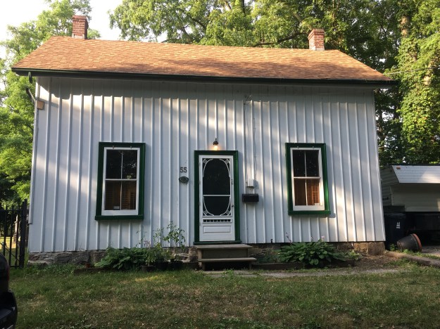
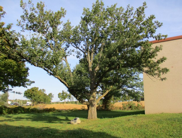
William D. Thomson was the eighth child of David and Mary and in 1848 he built a field stone house at the corner of the church lane and Brimley Road. As a result he would gain the nickname “Stonehouse Willie”.  William’s granddaughter Isabella lived in this house from 1942 to 1970 when she passed away at the age of 96.  When she graduated in medicine in 1902 Isabella was the first Scarborough woman to become a doctor.  She then served in India for 40 years before returning home.

IMG_5581

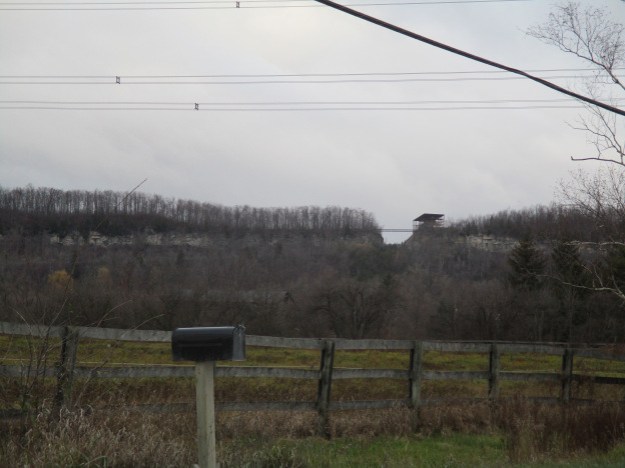
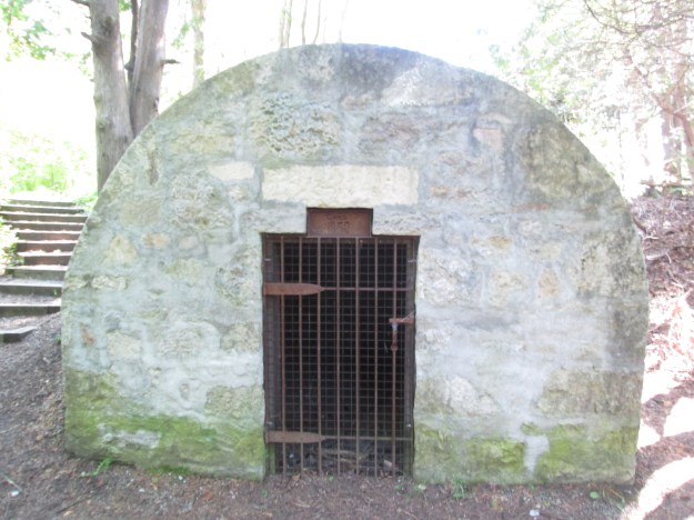
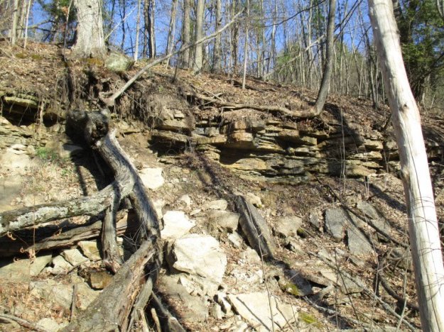
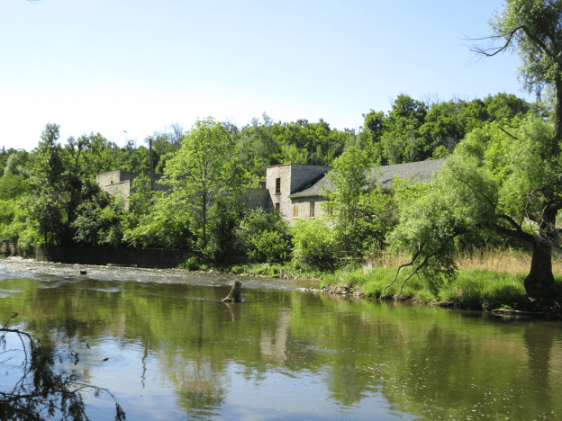
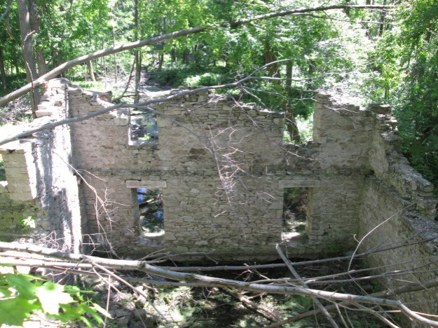
Just past the church is the home built by Andrew Thomson in 1840.  Andrew was a brother of David Thomson.  Across Brimley Road from the old lane way to the church was an additional parcel of land that belonged to David Thomson.  On the table lands above Highland Creek a village of longhouses stood around 1200 A.D.  Excavations revealed 17 longhouses and thousands of fragments of pottery and bone.  Many spear and arrow heads were also recovered.  Eight hundred years ago the scene would have been much different than the picture below with forests surrounding the village and the creek flowing much stronger than today.  The natives lived on simple agriculture, fishing and hunting.  They buried their dead on a hill to the east of the village.  Today we call it Taber Hill and the remains of 472 people were discovered there in two ossuaries.  Three red ovals mark the site of the longhouses on the county atlas above.

IMG_5582

Thomson Memorial Park sits on the homestead of David and Mary.  The park is also home to the Scarborough Historical Society which has gathered a small display of buildings and artifacts.  Both of the historical houses on the property have been reported to be haunted.  One display in the collection is the original tools  from the Hough Carriage Works that operated at Eglinton and Birchmount Road starting in 1856.  They produced carriages, wagons and bicycles for the area until the 1940’s when the buildings were demolished.  The equipment was saved and in 1984 the Scarborough Historical Society built a 1/4 scale shop in which to house them.  One of the tools on display is Hough’s 1871 manual drill press.  It was used to drill holes in wood and thin metal.

IMG_5594

The museum houses a Penny-Farthing bicycle that was made in the carriage works building some time in the 1880’s.  The bicycle adopted the name based on the wheel sizes.  In order to make peddling easy and high speeds achievable, the front wheel was much larger than the rear.  This design allowed the cyclist to travel a large distance relative to a short pedal stroke.  The invention of chain driven gear systems on bikes allowed the wheels to be smaller reducing the risk of falling from a height.  The name reflects the difference in size between a British penny and a farthing.

IMG_5598

This log cabin was built in 1830 and occupied by a lifelong bachelor named William Porteus McCowan.  It was typical of a first home for a new settler and would have been built from the first few trees cleared on the lot.  McCowan was a sheep farmer and shared the cabin with his workers who slept in the attic.  Other members of the McCowan family settled near the Scarborough Bluffs and McCowan Road is named in honour of the family.

IMG_5603

The Cornell house was built in 1858 and would be typical of a second house, built by an established family.  The Cornells were apple farmers and their 8 children supplied much of the labour.  The house was moved to this location in 1962 when the land it was sitting on was expropriated for a new railway bridge.  The house is furnished in the late 19th century style and has many original household items that belonged to the Cornell family.

IMG_5522


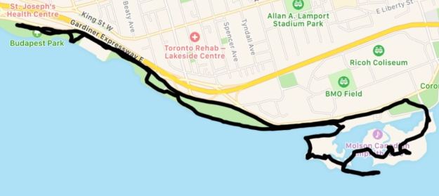
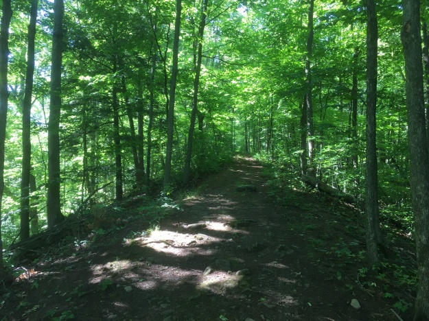
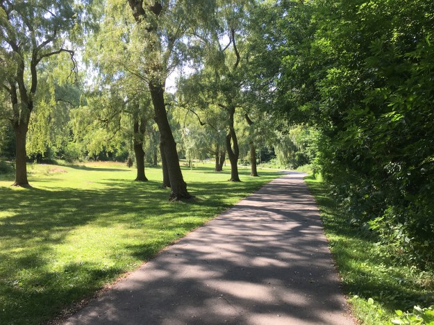
Thomson Memorial Park is 103 acres covering half of Scarborough’s first land grant and with all the trails, open space and historical museum it makes a great place to visit.

Google Maps Link: Thomson Memorial Park

Like us at http://www.facebook.com/hikingthegta

Follow us at http://www.hikingthegta.com

Ontario Place

July 15, 2018

Ontario Place was a jewel on the Toronto waterfront for 40 years before declining attendance caused the government to shut it down in October 2011 for the last time.  Plans were immediately announced that major renovations were planned and the park would re-open in time for Canada 150 in July 2017.  This didn’t happen and a change of provincial governments threatens to derail the project further.  I decided to take a walk around the park and see what is going on these days.

IMG_5271

Ontario Place was designed by Toronto architect Eberhard Zeidler.  A large part of the concept for Ontario Place came from the idea to have large display pods built over the water.  The idea likely was inspired by Expo 67 where Pods were built over the Saint Lawrence River in Montreal.  Three artificial islands were created in the harbour that are connected to the mainland by three bridges.  The central bridge connects to the set of pods which make up the middle island.  The five elevated pods are interconnected as they stand above Lake Ontario.  Each pod is a three story structure that encloses 743 square metres of space.  Originally used for multimedia exhibitions, they were intended to be flexible and accommodate other uses over the years.

IMG_5275

This is the seventh season that Ontario Place has been largely abandoned although it does appear to be open as I was not challenged by the staff I passed on the bridge.  The entire time that I spent walking through the park I met less than twenty other people.  It truly felt like walking through a ghost town.

IMG_5278

In the 1980’s over 3 million people per year visited the park but by 2010 the number was down to only 10% of that.  The log flume on the west island was always sure to soak the riders, a welcome treat on a hot day.

IMG_5286

The park was in a continual state of development with new attractions being added as the years went by.  The original pods were not the raving success that was envisioned but the idea of showcasing the northern part of the province was seen as a way of potentially attracting professionals to relocate north where there was a shortage of people.  In 1980 silos were constructed that resemble farm silos that stand across rural Ontario.  The wildlife displays didn’t do as well as expected and the silos were eventually converted into additional rides.

IMG_5290

The Cinesphere showcased the world’s first permanent IMAX projector on a screen that was 24 metres wide and 18 metres high.  The dome is 35 metres wide and when it opened in 1971 it became the icon of Ontario Place.  It was so successful that there was a regular line-up to get in.  On a school trip we saw a movie called Snow Day in which it felt like we were in a school bus running out of control on snowy roads.  A good choice for kids who had arrived via school bus.  Cinesphere was closed in 2012 along with the rest of the park but in 2014 the dome was given a cultural heritage designation.  As of 2017 the theater is open again on a full time basis with state of the art equipment.

IMG_5299

March of 1969 saw the first activity in the building of Ontario Place and it opened just over two years later on May 22, 1971.  Construction of the Cinesphere and the pods is seen in this 1970 photograph from the Toronto Archives.

20120201constructionview

The design called for display pods suspended over the water to display the scientific and technological wonders of Ontario.  Constructing the pods over open water became an engineering problem and the costs mounted to the point of consuming the budget.  To reduce the costs a protective break wall was designed using three obsolete lake freighters.  They were sunk and filled with concrete to create a safe harbour for a marina.  The ships can be walked out to the end where one of the bridges is open for exploration.  The three ships anchors are also preserved on the third ship.  The picture below shows the outline of two of the ships where they meet.

IMG_5302

The 1970 photo below shows the three ships, reported to be the The Shaw, The Houghton and The Victorious in their positions with the west island being formed out of lake fill.

Ships

The pods are now underutilized and the iconic sets of stairs on the outside are peeling and no longer ring with the sounds of crowds filled with laughter.

IMG_5321

The water park covered much of the east island and went under the name Soak City.  A series of coloured water slides was installed in the 1990’s and was a popular attraction until the park closed.  The slides remained in place until May of 2016 when they were disassembled to prevent a potential injury to people who insisted on climbing up and even rollerblading down them.  Today the central support tower is all that’s left except for a few abutments to mark the site of the water park.

IMG_5341

Trillium Park, containing the William G.  Davis Trail is the first part of Ontario Place to get a completely new lease on life.  This area was formerly a 7.5 acre parking lot.  Today it has been converted into a lush green space with a 1.3 kilometre trail named after Bill Davis who was premier in Ontario in 1971 when Ontario Place first opened.  The trail passes through an artificial ravine and contains the Moccasin Marker.  The carvings on either side of the ravine are intended to remind us of those who were here before us.

IMG_5350

I picked a good time to visit as the Indy was on and parts of Lakeshore Avenue were closed for the race.  I decided to park at Budapest Park and walk part of the Martin Goodman Trail to reach Ontario Place.  I used the Bruce Trail App to track my walk which came out to 10.4 kilometres.  By parking at Ontario Place you can explore the area with three or four kilometres worth of walking.   Be sure to make the walk along along the three sunken ships that is represented by the tail extending out into the lake on the map below.

Ontario Place

Having visited the park in 1972 or 1973 with my aunt and uncle, both of whom have passed on, I have fond memories of an Ontario Place that was vibrant and full of people.  It’s sad to see what has become of our waterfront park especially when there is no clear timeline for completion of the renovations.

As a parting thought, would you have wanted this job building the Cinesphere?

Cinesphere

Google Maps Link: Ontario Place

For additional places to explore visit our recent Greatest Treks 3 post.

Like us at http://www.facebook.com/hikingthegta

Follow us at http://www.hikingthegta.com

The Great Esker

July 7, 2018

This week I bought the Bruce Trail App for my phone and so it got it’s first workout.  After identifying a section we hadn’t been on before we set out for the parking area on the map (8th line north of 22 Side road, north of Georgetown).  There are several places that you can pull off and park that are not on the map including where the main trail crosses the road a little farther north.  With the tracking feature turned on it marked our trail as we progressed and created a record of the hike that can be saved toward earning trail badges.

Great Esker

We entered on the Eight Line Side Trail and made our way to The Great Esker Side Trail.  Along the way we identified the remains of an old car in the woods.  It has clearly been there for decades as it has no motor and is surrounded by mature trees. It is in a very advanced state of decay.  The front bumpers and grill pattern were quite unique in the various car models of the 1940’s.  Having looked through hundreds of online picyures, positive identification wasn’t possible but the closest candidate was a 1946 Chevy Stylemaster.  That particular car was a sedan and this model was most likely a truck.

IMG_5128

Flowering Raspberries grow along the trail in many places.  Their flowers are quite large for the raspberry family and have a long period of blooms which also makes them of special interest to honey bees.  The fruit looks like a large flat raspberry and is used by mammals and birds.

IMG_5176

Eskers are glacial deposits that run in nearly straight lines and rise above the surrounding landscapes.  They are formed during the melting phase of the ice age when water is rushing in a river either over or under the ice.  The formation of eskers is described in greater detail in our earlier post The Brampton Esker.  The Great Esker Side Trail runs, in part, along the top of an esker.  It stands about 30 metres above the surrounding terrain but is much shorter than the one in Brampton.  As far as eskers go, the Great Esker isn’t so great.  The Thelon Esker is almost 800 kilomtres long.  The trail leads directly up the esker.

IMG_5133

The escarpment is made up of limestone and harder layers of dolostone.  Scattered throughout the landscape are large granite boulders that appear to be out of place.  They have been carried by the glacier and deposited across the province by the retreating ice sheet.  Rocks that are different sizes or minerals than the ones common to where they are found are known as glacial erratics.

IMG_5134

Old stone fences run through the trees marking off the earlier fields.  More recently some guide wires have been put in some places along the trail.  These are growing into the trees in several spots.

IMG_5135

Most of the mayapples, or mandrakes, have been harvested by the local wildlife but a couple large ones remained that are still green.  When they start to turn yellow they will put off a pungent odor that attracts raccoons. It is suggested to remove the seeds if you do happen to harvest some of this native fruit.  You’ll have to be lucky because the raccoons check daily for the newly ripening fruit.

IMG_5137

Butterflies abound along the trial and this Appalachian Brown was one of several flittering among the plants.

IMG_5141

The poison ivy doing very well along the sides of the trails.  Urushiol oil in the leaves and stem causes an allergic reaction in 85% of people.  It is white when the stem is broken but turns black upon exposure to oxygen.  The oil is highly concentrated and a drop the size of a pin head can cause an allergic reaction in 500 people.  In the United States about 350,000 people a year get a rash that can last for up to 3 weeks.

IMG_5144

One of the truly interesting boardwalks is this one that takes advantage of this tree and the massive root system to carry the trail.

IMG_5152

Snow’s Creek Falls are located at the intersection of 27th side road and the 8th line so we made a detour to see how much water was there at this time.

IMG_5163

It was certainly cool to check out the Great Esker Side Trail and take the Bruce Trail App for a test run.  It likely means more hikes on the Bruce in the near future.

Google Maps Link: The Great Esker Side Trail

Like us at http://www.facebook.com/hikingthegta

Follow us at http://www.hikinghtegta.com

Bruce Trail – Toronto Section

Sunday, July 8, 2018

Starting in 1959 the Bruce Trail was conceived and developed with the northern terminus being unveiled in 1967.  The trail covers 890 kilometers between Tobermory and Queenston.

For those in the GTA we are lucky because the Bruce Trail runs across our doorstep with large parts being accessible within an hour from midtown Toronto.  The Toronto Section covers 50 kilometers of main trail and 55 additional ones of side trails between Kelso and Cheltenham.  Exact maps of this section can be purchased from the Bruce Trail maps covering maps 11-14 and a more general overview is seen below.  For slightly more than the price of four maps you can buy the Bruce Trail App for your phone.  It does pretty much everything except hike the trail for you.  The annual section end to end hike is scheduled for September 8-9, 2018 and covers an area that has been explored both in terms of the trail and local history in a number of stories.  Hiking the GTA has put together a series of links to these local treasures along the trail.


Toronto section

The trail section starts at Kelso if you are hiking from the south toward the north.  The conservation area has many of it’s own trails and the area was once home to a lime industry.  Two kilns remain near the main trail.

img_1235

Just a short distance north of the 401 the Hilton Falls side trail runs for 9.2 km and let’s you visit the falls with the remaining portions of the original mill.

Hilton

The trail follows the edge of the escarpment and passes The Gap created by Dufferin Quarries in 1962 to allow extraction of aggregates from an open pit mine.  The trail crosses the gap on a bridge allowing you to see the restoration efforts that will eventually turn this area into a parkland.  The aptly named Restoration Side Trail will let you have a view of the restoration process in a closed section of the pit.

img_1300

After passing through the Scotch Block the trail leads to Speyside.  This little community has one of Ontario’s only heritage trees. In 1937, to celebrate the coronation of King George VI on May 12th, acorns from Windsor Park in England were sent all across the commonwealth. The Royal Oak Of Speyside was planted by the local school children.

img_0309

Several side trails extend from the main trail over the next few kilometres.  One of these, The Canada Goose Side Trail, leads through an old homestead and along the edge of another one of Dufferin Quarries limestone extraction operations.

img_2518

The next heritage site along the trail is found at Limehouse where the remains of several lime kilns have been preserved.  This area became well known for the production of lime used in the construction industry.  One of the interesting artifacts is the restored powder house where the blasting powder was stored.

Attachment-1

From Limehouse the trail continues north using a combination of trails and sections of roads until it reaches Silver Creek and Scotsdale Farm.  One of the defining features of Fallbrook is the stone arch bridge that was built in the 1870’s.  The stone for the bridge was taken from the decommissioned saw mill just downstream.

img_7651

Silver Creek Conservation area is also home to the Irwin Quarry Side Trail.  This trail leads to one of the 50 small quarries that have come and gone along the escarpment.  The quarry was successful because the layer of soil on top of the limestone was very shallow allow for easy extraction.

IMG_5117

The Credit Valley Footpath is another side trail that runs for almost 10 kilometres and leads to two historical sites.  The Barber Paper Mills in Georgetown dates back to 1837 but unfortunately it is suffering from demolition through neglect.

Barber

A couple of kilometres farther downstream the Barbers erected the first dynamo in Canada to generate electricity and transmit it over wires to power a mill.

dynamo 4

Meanwhile, the main trail carries on through the Terra Cotta Conservation Area.  This park has many of its own trails and is home to a 12-metre plunge waterfall on Roger’s Creek.

terra

The Toronto Section of the Bruce Trail ends near the Cheltenham badlands.  This area of Queenston Shale was exposed to erosion in the 1930’s and was crossed by the main trail until recently.  The area had been closed for a few years because people wouldn’t stay on the trail and were increasing the erosion.   A new parking lot and boardwalk have been installed this year to allow people to check it out up close.

Badlands

The Toronto Section of the Bruce Trail, along with all the side trails, provide people in the GTA with quick access to some great hiking with plenty of views and historical artifacts.

Google Maps Links for the stories are included within the links.

Check out all three of our Greatest Treks compilations here: OneTwo, Three

Like us at http://www.facebook.com/hikingthegta

Follow us at http://www.hikingthegta.com