Monthly Archives: January 2021

St. Marys – The Town of Stone

Sunday, January 31, 2021 (pictures taken July 24, 2020)

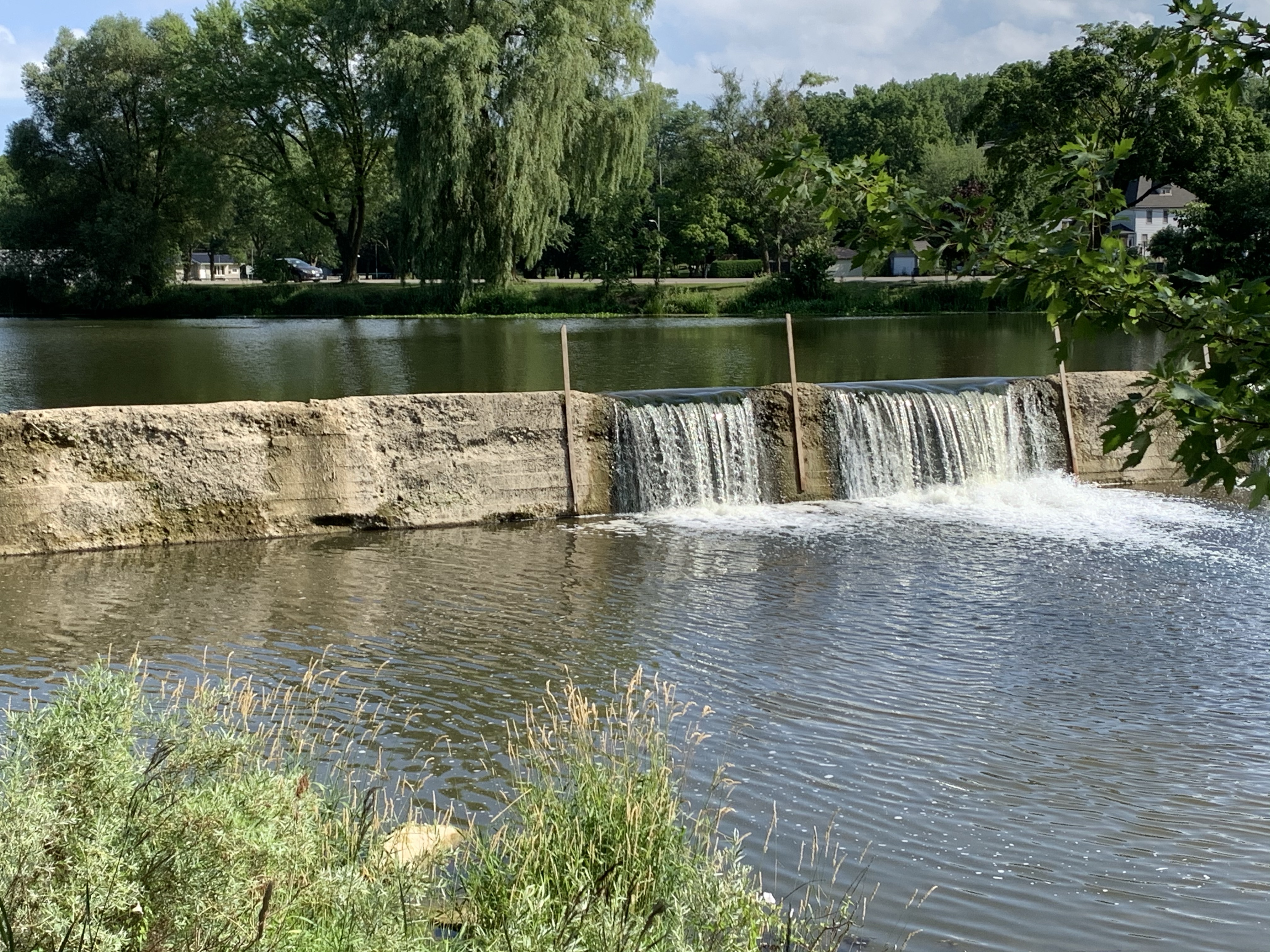
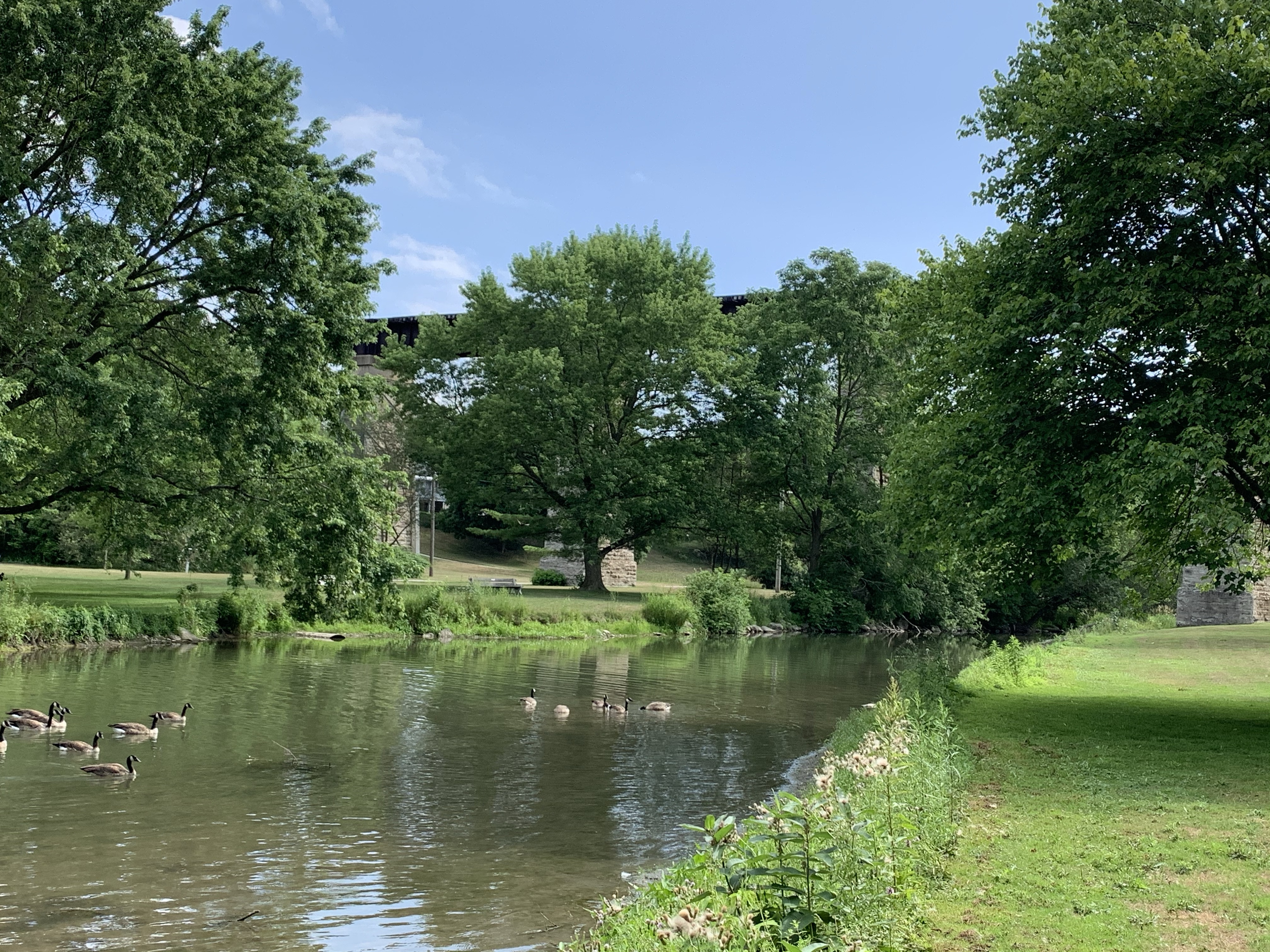
St. Marys was founded in 1841 when Thomas and James Ingersoll bought 400 acres of land near the junction of Trout Creek and The Thames River. They dammed the Thames River just below the confluence and built mills on the south side of the present Queen Street. The mill race that fed their mills was incorporated as an integral part of the Victoria Bridge when it was built in 1864. The mill race was restored in 1980 and now has its own heritage designation. I visited here in July when the first wave of Covid was just relaxing and took these pictures that I present now that travel is once again restricted due to the pandemic. Hopefully we’ll get back to newly explored material before too long.

By 1845 there were a number of small limestone quarries operating in the area and many of the early homes and buildings were constructed from this material. The town had already attracted several stone masons and had three stores to serve its 100 inhabitants. The number of stone buildings that survive in St. Marys makes it a beautiful place to visit when safe to do so. The stone mill still stands beside the river where it sparked the community that has such an interesting heritage to share.

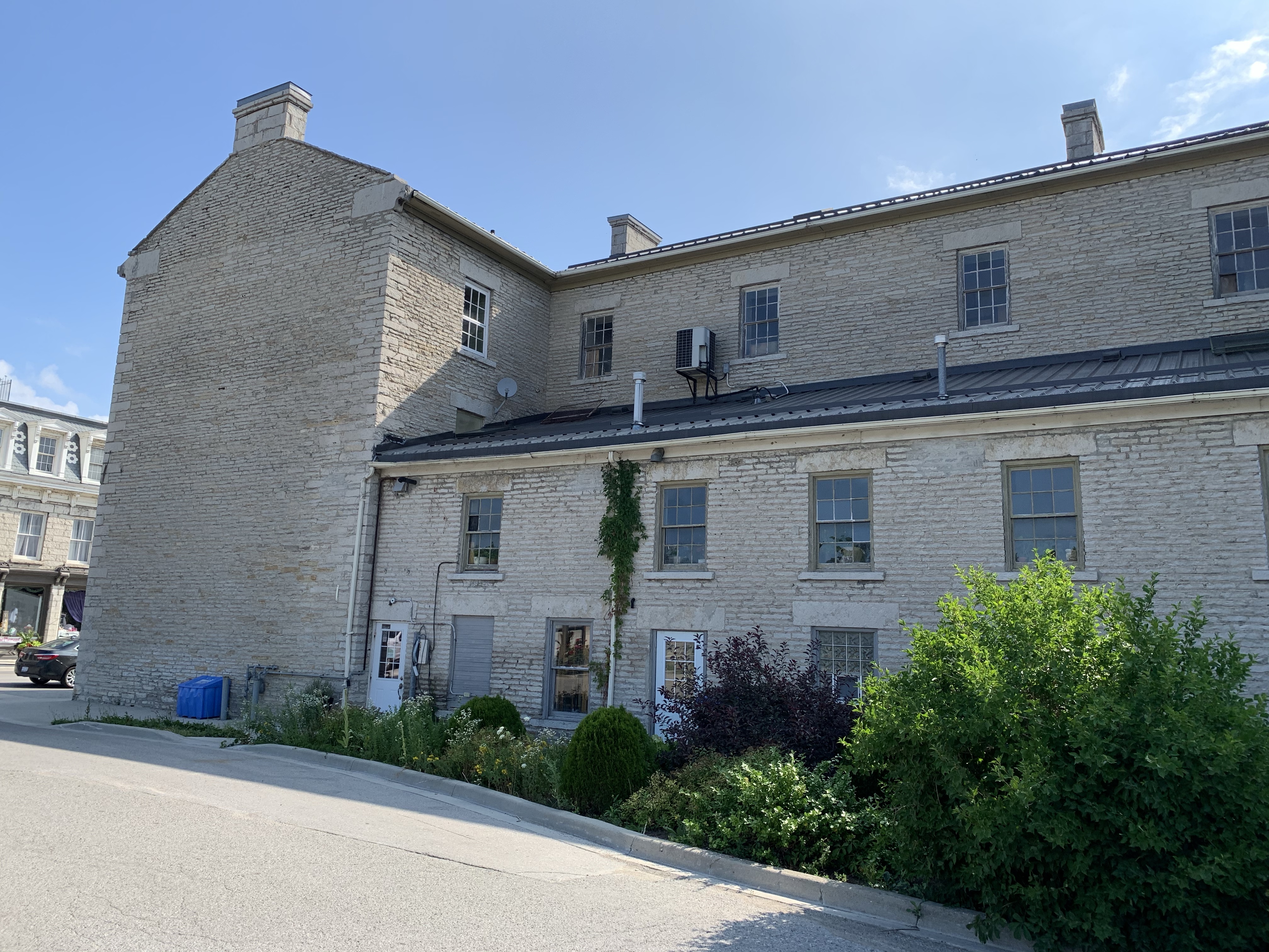
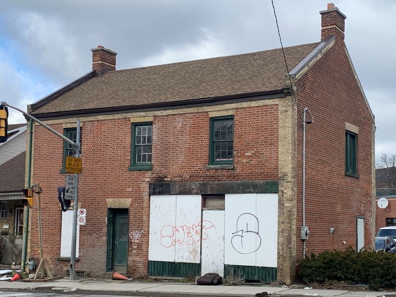
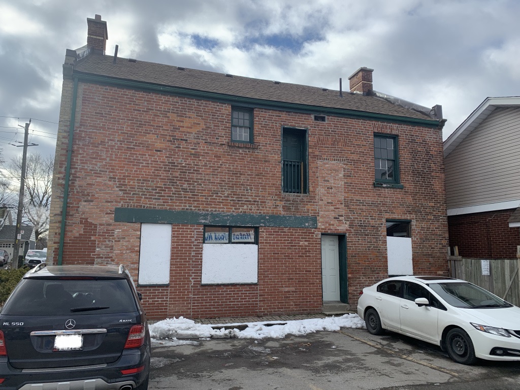
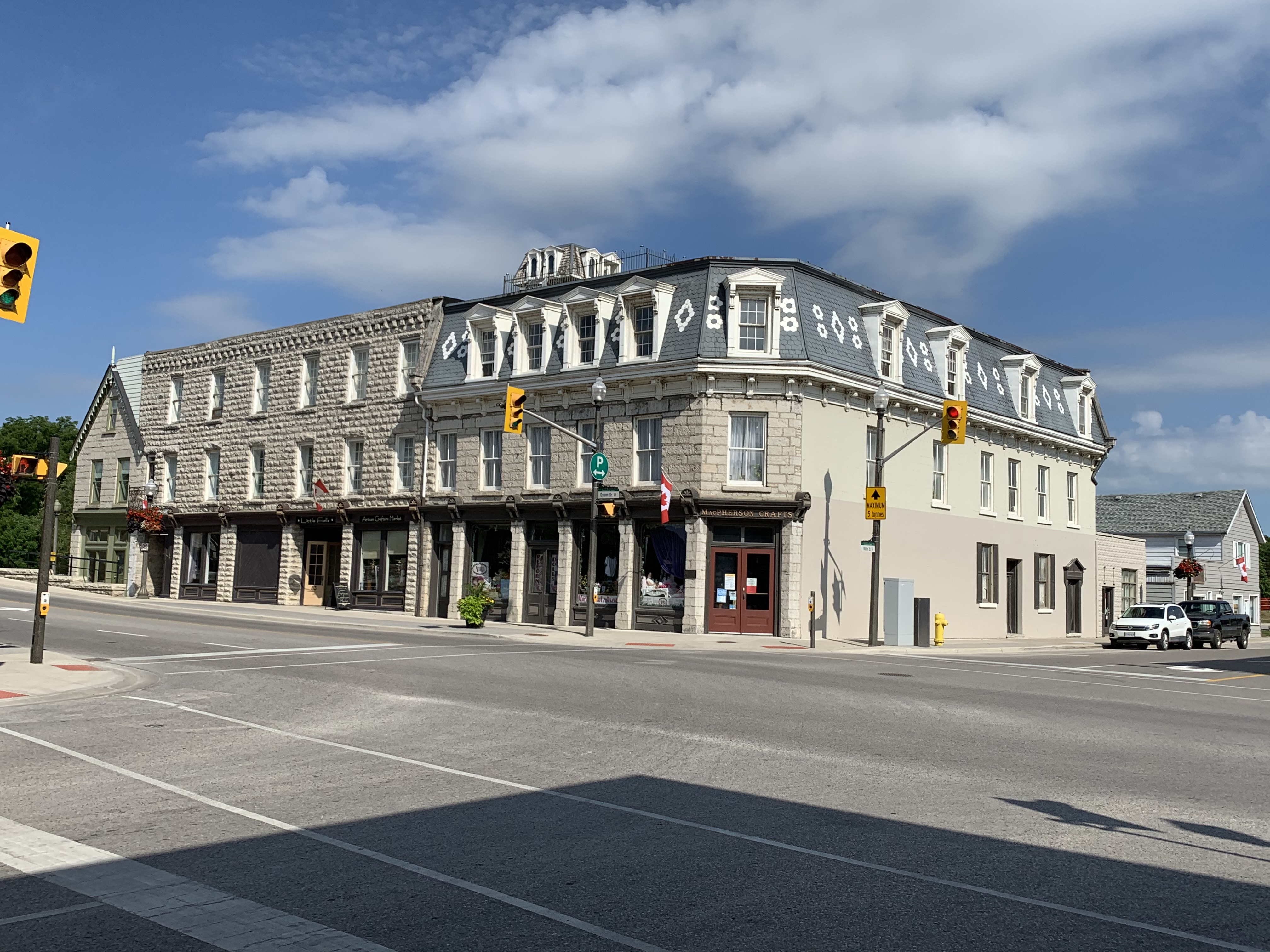
The Millers Residence was built in 1858 beside the mill race and across the street from the mill. An entire commercial block has been added to the original two and a half story home but it can be seen in the left of the picture below. The gothic influenced gabled roof sets it apart from the three story Georgian commercial block in the middle and the mansard roof of the Queen Anne styled section on the end.

The Grand Trunk Railway split in St. Marys with one line headed to Sarnia while the other went to London. Both required high level bridges that were built in 1857-1858. The London bridge is seen below as it crosses over Trout Creek.

The Imperial Order of Oddfellows in St. Marys had been expanding and had outgrown their original frame building. They commissioned a new hall and opera house which they envisioned to be the finest Lodge anywhere in the Dominion. When the building opened in 1878 they occupied the third floor which used to have a central gable. The Opera House occupied the second floor and three retail businesses operated between the gothic entrances below the spires on each end. The building lost money for the Oddfellows and they were forced to sell it in 1904. For three years it was home to a harness maker before being converted into a mill that operated until 1973.

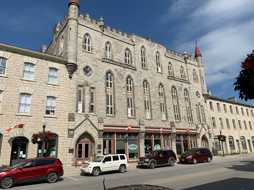
The limestone block to the south of the Opera House was built in 1868 to serve as a store for Theodore Hutton with his residence above. Starting in the 1930’s it served as as a drill hall for the local militia and is also known as the armouries building.

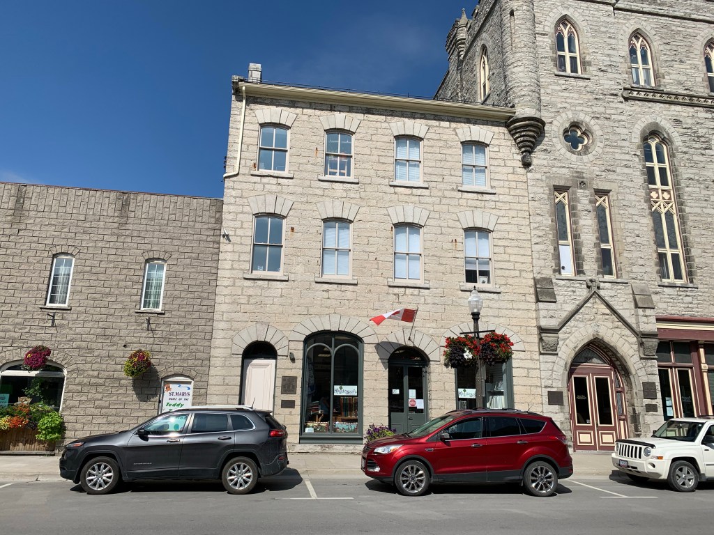
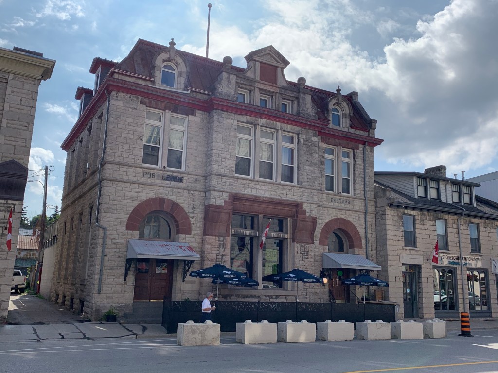
St. Marys post office and customs building stands across the street from the Opera House. It was built in 1903 and was replaced with a newer facility in 1956.

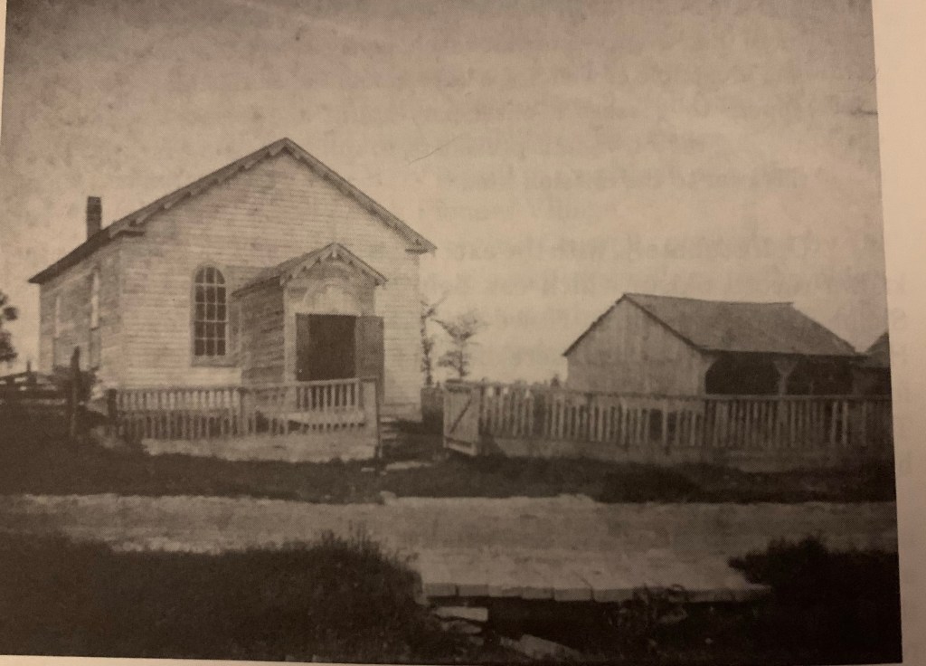
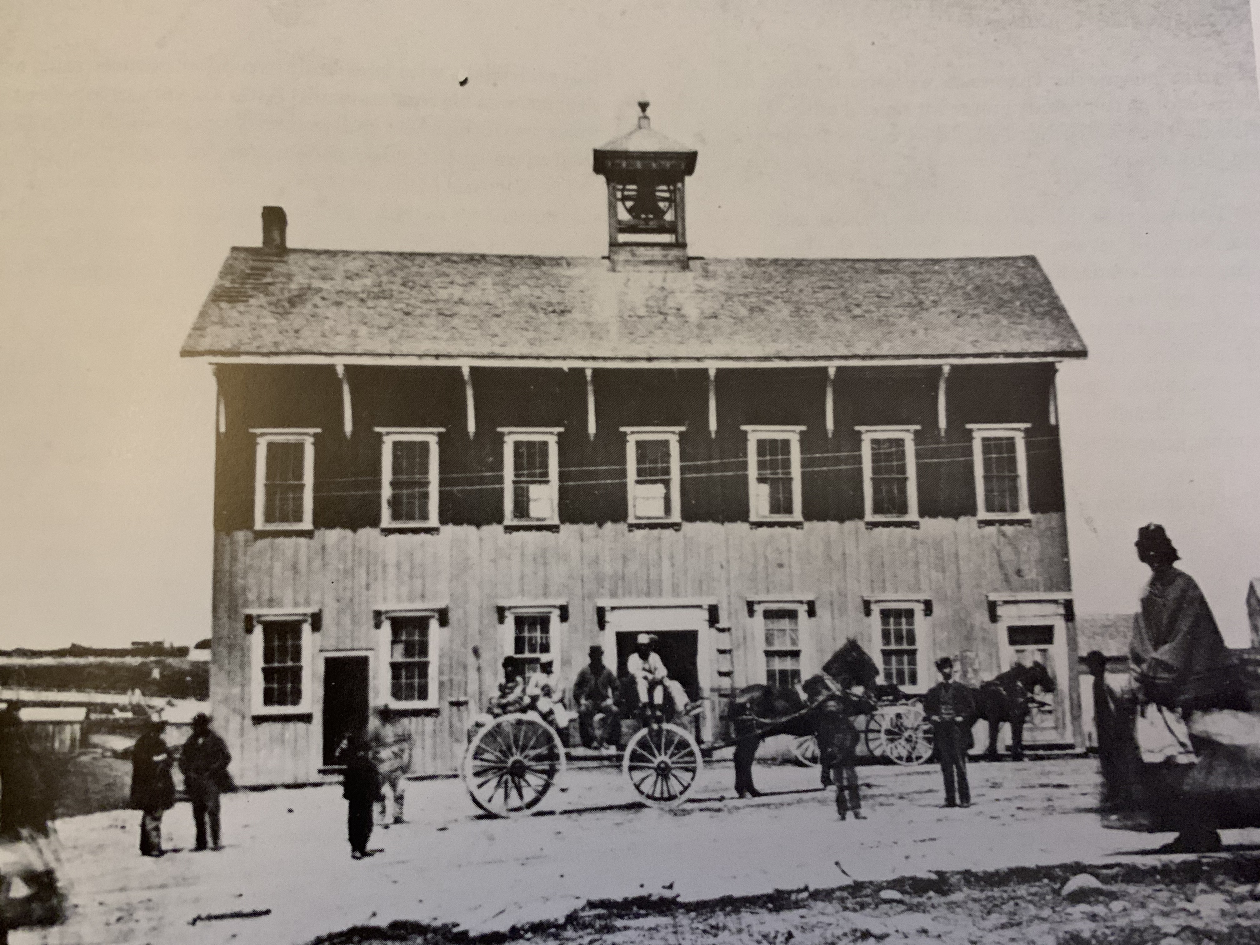
As St. Marys grew the original town hall on Water Street quickly became obsolete, being small and located away from where the town was now developing. In 1859 a new location was chosen on Queen street and a two story town hall was constructed which housed the town clerk, police, jail and several butchers. The smell of the slaughter and preparation of meat permeated the building and it was quickly deemed to be a problem. The picture below was taken in 1865 and is from the book Early St. Marys by L. W. Wilson and L. R. Pfaff.

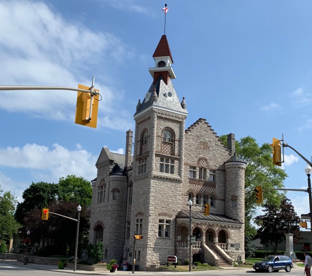
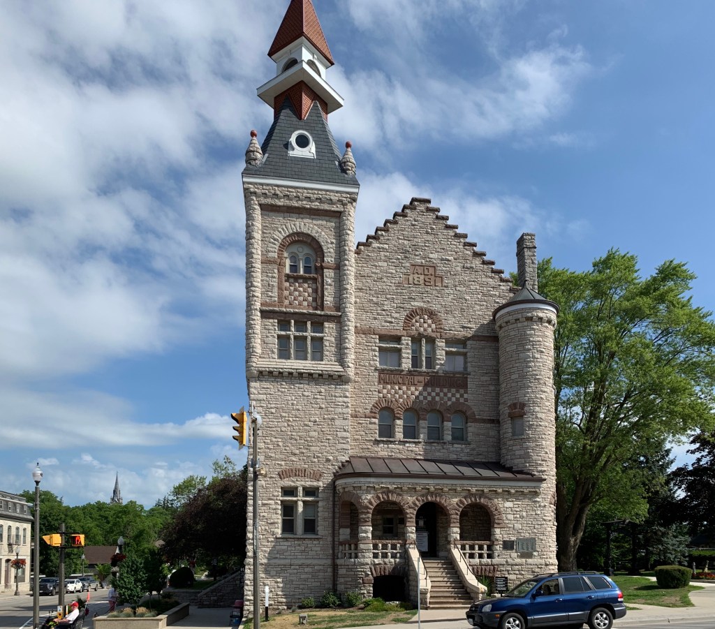
By 1889 when the frame town hall was destroyed by fire no one considered it to be much of a loss. Plans were put in place to build a grander structure, this time from stone. It was completed in 1891 and remains one of the signature buildings in the community.

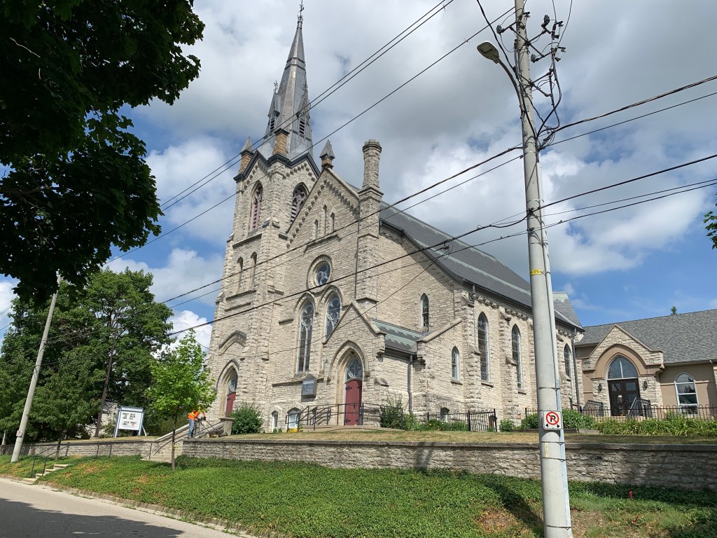
James Ingersoll donated land for churches including the Presbyterian Church in 1849. They built a frame church in 1852 which was replaced with the present stone building in 1879. The congregation had been split over the appointment of a certain pastor and Knox Presbyterian also operated in town. Both congregations survived the United Church movement in 1925 but continued to operate separately until 1964 when 46 year old peace talks finally mended the rift in the Presbyterian congregation in St. Marys.

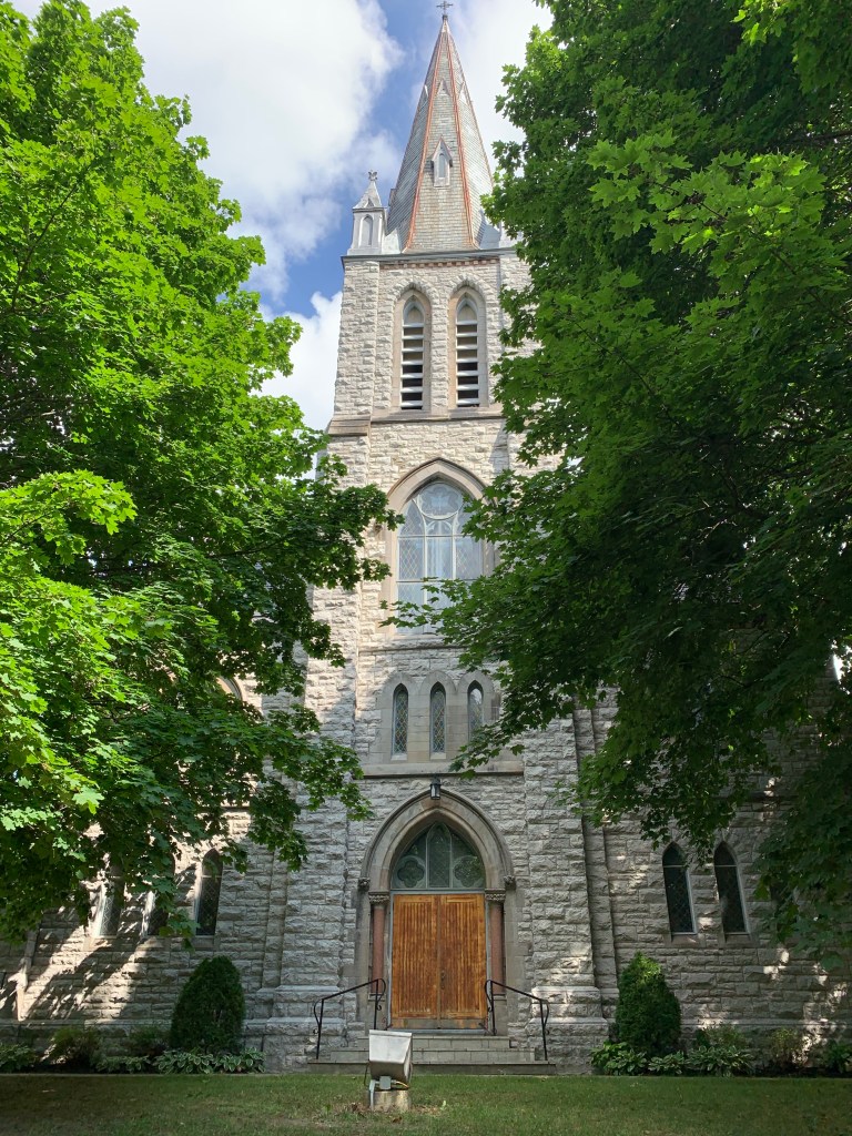
The Catholic congregation in town is aptly named the Holy Name Of Mary Catholic Church. Their second building still houses the congregation in a stone structure dating to 1893. Unlike the smaller stone church that formerly stood on this site, this one has an impressive tower. An 18-metre steeple stands on top of the 21-metre tower.

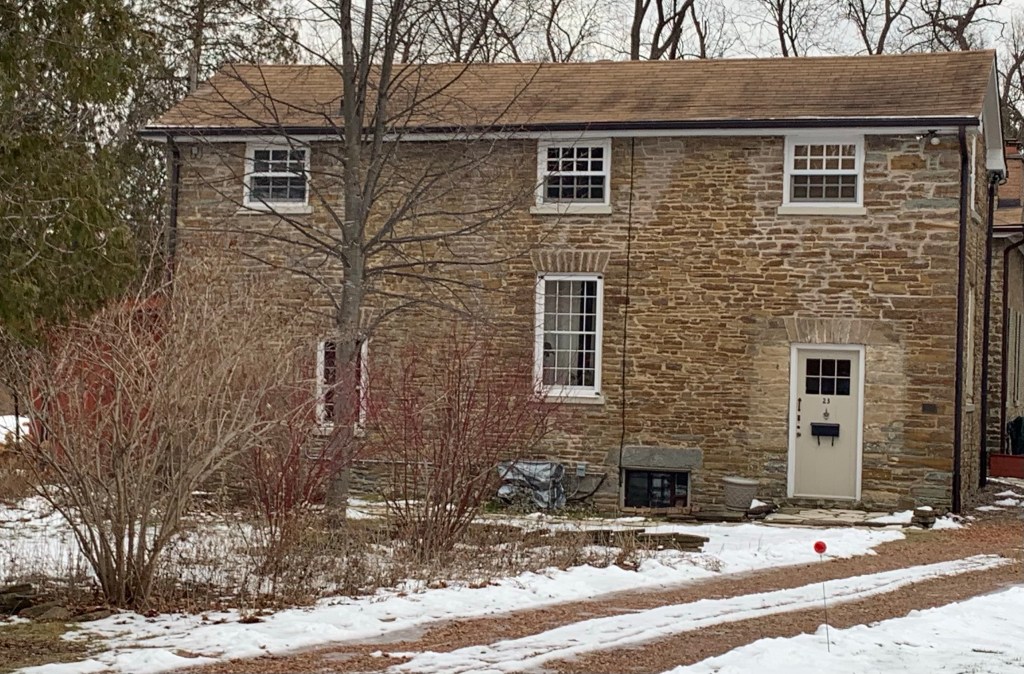
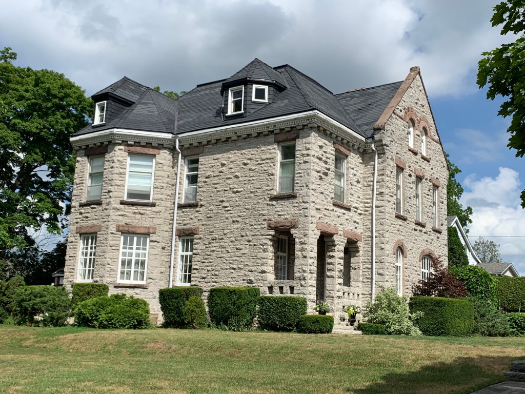
St. Marys features some very interesting stone houses dating back to the earliest one which was built by the Ingersolls in 1843. Some are simple Georgian cottages while others are mansions built later in the 1890’s.

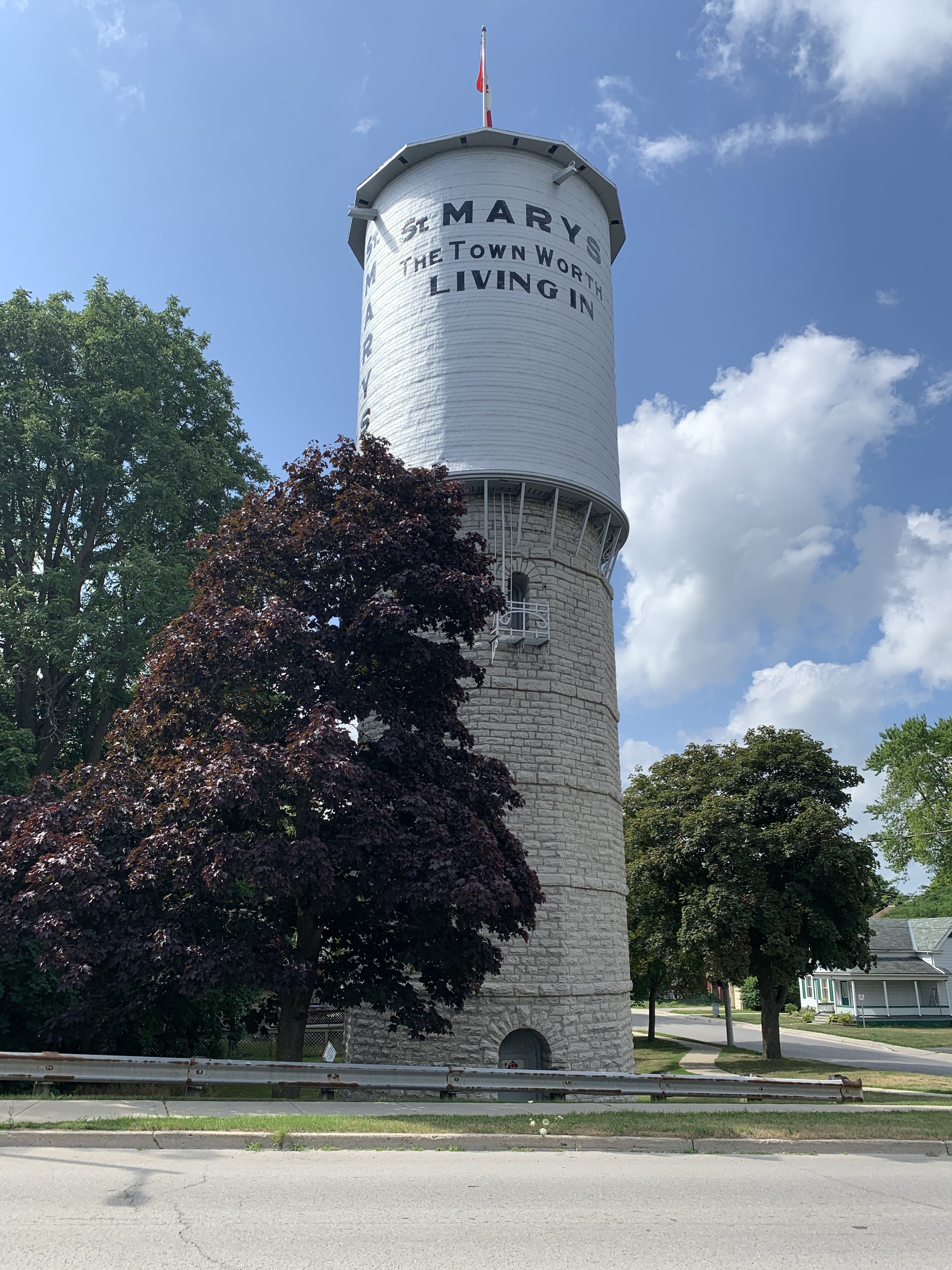
By 1899 the Thames River and Trout Creek were both polluted and the citizens approached the town council to call for construction of a waterworks system. This would include waterworks buildings near the Grand Trunk Trestle over Trout Creek, a stone water tower for storage and pipes running throughout the town. The system was completed and put into service in May 1900.

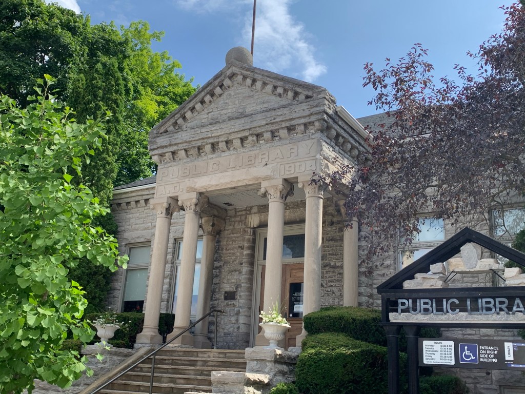
Andrew Carnegie was an American industrialist who had a passion for funding libraries. Originally he built libraries in his home town in Scotland and his adopted town of Pittsburgh. Eventually he spread his influence founding 2509 libraries between 1883 and 1929 of which 125 were in Canada. In 1904 he donated $10,000 for the library in St. Marys which was built in the Grecian style which was his personal preference.

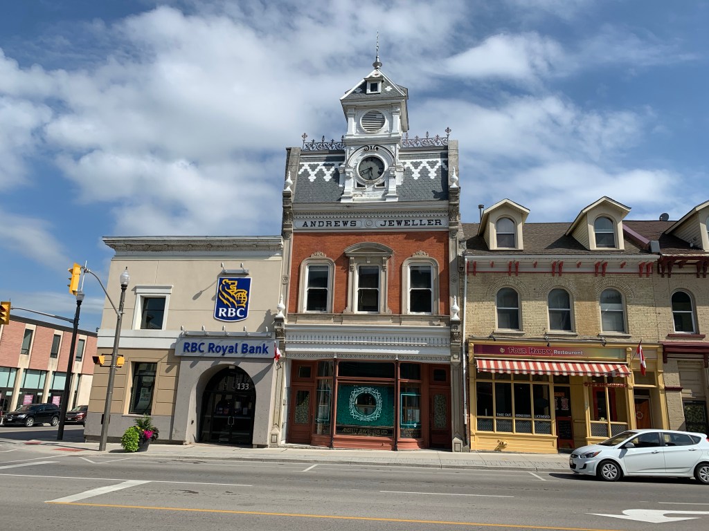
Andrews Jewelers has been a fixture in St. Marys since 1869. The Andrews family had arrived in town in 1857 when Henry Andrews came to lend his stone mason skills to the stone abutments of the London Bridge. William Andrews replaced his original frame shop with a building that was considered to be architect and mason William Williams’ masterpiece. Opened in 1884 it is a rare example of a building that is essentially unaltered inside or out. The side and rear walls are made of St. Marys limestone while the front is made of bricks with finely worked stone dressings. The clock is 4.5 feet in diameter and cost over $1,000, about $25,000 in modern currency.

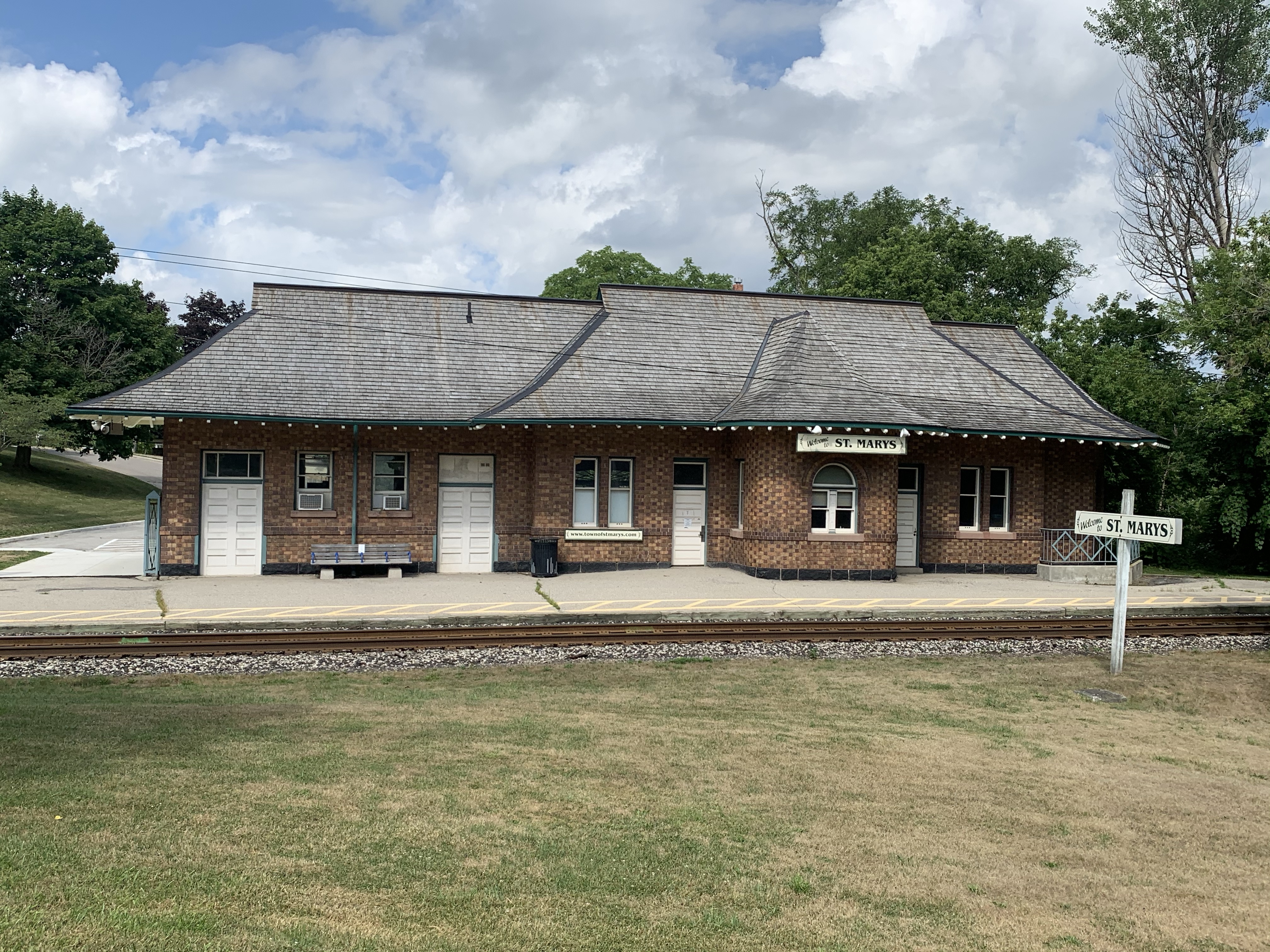
The Grand Junction Depot was built in 1907 to supplement the Junction Station and replace the earlier frame station on Elizabeth Street. It was built from a brown glazed brick known as Logan brick and is a departure from the stone architecture in town. Slated for demolition in the 1980’s it has been preserved and restored.

St. Marys is a unique town because it’s stone buildings have survived the test of time. There are many other examples that can’t be presented in this length of an article but are equally interesting.

Google Maps Link: St. Marys

Like us at http://www.facebook.com/hikingthegta

Follow us at http://www.hikingthegta.com

Also look for us on Instagram

Omagh – Ghost Towns of the GTA

Sunday, January 24, 2021

The community of Omagh is the last one in Trafalgar township that still retains some of its rural characteristics. This is the reason that the town of Milton is considering designating it as a cultural heritage district. This would allow it to survive the encroaching development that threatens to over-run it. The photos presented below were taken early in November 2020 and have been held in reserve in case a future provincial lockdown might prevent extensive travel and exploration. As such, it’s time to explore the historic hamlet of Omagh. It was founded in 1818 and never grew much beyond the intersection of todays Britannia Road and Fourth Line near Milton. The 1877 county atlas image below shows the small cluster around the intersection as well as the Presbyterian Church to the west of town.

Trafalgar Township was settled in two parts. The southern section, now known as Oakville, was settled primarily by United Empire Loyalists (UEL) who came from the United States. The northern section, now Milton, was settled largely by people from the British Empire. The original name for Omagh was Howellville after John Triller Howell who arrived in 1805 as a boy. His family were UEL and the local MP John White didn’t want the town named after someone he considered to be a Yankee. He persuaded the local land owners, who were mostly Irish, that if they chose Omagh he would get them a post office with that name. Ironically, the post office ended up being in Howells store and hotel. The building has been altered greatly over the years but it still stands on the north east corner of the intersection. The side facing Britannia used to have a large porch and was the main entrance to the store.

This archive picture was taken before 1920 and shows the building when it served as a store but before it started to sell gasoline for those who were enjoying the newly developing automotive craze. By 1980 the store had closed and the building has served as a private residence for the past 40 years.

The south east corner of the intersection has one of the few actually abandoned homes in the little community. This property was originally deeded to Kings College (University of Toronto) in 1828. Between 1862 and 1883 the property belonged to William McLean and featured a home that faced the fourth line. By 1930 it belonged to Edward Delvin who built the current home which faces Britannia.

The small hamlet of Omagh once had four churches, which illustrates the significance the community had within the local rural area. The Wesleyan Methodist Church was built in 1854 with seating for 300. It was destroyed in a fire sometime around 1914. The Omagh Disciples of Christ built their church in 1850 and continue to operate to this day. They changed their name to the Church of Christ in 1930. This building features rounded windows as opposed the common pointed arches that were popular in Gothic Revival designs for churches of the era.

The church cemetery contains some of the earliest burials in the community, a few of which have been collected and restored into a small cement slab. Other more recent stones can be found on either side of the church.

An Anglican Church was built in 1868 and operated until 1946. It was demolished in 1947. The Omagh Presbyterian Church is west of town on a one acre lot of land which was purchased on April 31, 1838. The local Presbyterians originally built an small wooden building which they painted white. Seventy years later, in 1908, a building committee was formed to look into the construction of a new church building. A year later in 1909 they laid the cornerstone of the present brick building. In 1925 they resisted the movement to join the United Church and today continue to serve as a small community church with several members who have worshiped there for their entire lives.

Omagh Presbyterian cemetery continues to receive burials. The open area to the east of the church contained the original drive sheds for horses. These were removed when automobiles replaced carriages as the primary method of transportation. In 1877 there were 100 residents but by 1935 Omagh was down to 6 houses and 3 churches, 4 farms and the ball park which was created in 1930.

The house featured below was built in 1882 as the parsonage for the Methodist Church. In 1919 the Methodists sold the parsonage as their church had been destroyed and they no longer had a pastor. Standing on the south west corner, the house has the distinction of being the only parsonage in the small town.

Children in early Omagh had to walk a concession west to Boyne to go to school. The first school in the community may have been built as early as 1828 on a lot on the south east side of the intersection. In 1874 when a new School Section #6 building was erected, it was located across the street. It closed in 1956 and was demolished in 1968 with the bricks being recycled into the home that replaced it at 10095 Britannia Road. The bell was saved and installed in a memorial at the ball park.

This little house was built in 1928 according to tax records as a rental property, likely for a farmhand on the Devlin farm across the road. It has been left empty for several years now.

The barn on the former Devlin property was built in 1900 but is in fairly poor condition. The heritage farm house that stood on the property was demolished in 2001 which removes some of the heritage value of the barn. it’s unclear if there will be any effort to save the barn before wind and weather conspire to bring it down.

A large shed on the property is in even worse condition. With most of the rear roof missing, as seen from the ball park, it is unlikely to be standing for very much longer.

Milton town council made the decision in December 2019 to recognize Omagh as a Cultural Heritage Area and now a management plan has to be drawn up and implemented. This will help ensure that at least the structurally sound buildings in town will be retained as the surrounding farmland is developed for housing.

Google Maps Link: Omagh

Like us at http://www.facebook.com/hikingthegta

Follow us at http://www.hikingtegta.com

Also look for us on Instagram

Pine Point Golf and Country Club

Saturday, January 9, 2021

There are currently 13 golf courses in Toronto and another 87 within 20 miles of Toronto which attests to the popularity of golf. Between 1869 and 1919 there were thirty courses opened in the city but many of them have been built over with homes. At least two of them have been turned into parks that we’ve visited. The former York Downs Golf and Country Club is now Earl Bales Park. Similarly, Pine Point Golf and Country Club is now Pine Point Park.

Pine Point Golf and Country Club wasn’t one of these original 30, nor is it one of the remaining 13 as it came and went between then and now. In 1925 it got its start as the Riverside Golf Course. It consisted of 225 acres and was operated by Cecil White until 1932 when he sold it to Bert and Frank Deakin. This father and son partnership rebranded it as Pine Point Golf and Country Club. They built a new club house in 1932 to replace the existing one.

They experienced disaster on the night of August 6th, 1938. At 2:20 in the morning Frank Cech was watering the far greens on the course when he saw the glow of the blaze. The club house was completely destroyed before the Weston Volunteer Fire Brigade could put it out. As soon as the clean up was complete they set about building a new club house. Things carried on until 1950 when the government bought a strip through the middle of the golf course for construction of the 401. Another 22 acres were bought on the north side of the new highway for the creation of a new park. Pine Point Park was opened in 1957. The picture below shows the back of the club house and a bunch of newly planted trees.

The main chimney still sports the logo from the days when golfers would congregate here before and after a round of golf.

The chimney on the south side of the main door is crumbling badly and appears to be hazardous. You wouldn’t want to be walking below when one of those large stones dropped out.

Below is a 1953 aerial photograph from the Toronto Archives. The small circle on the left is the club house featured above. Shapes of greens and sand traps can be seen in the circle at the centre of the picture while the larger circle shows the bridge over the Humber River. Meanwhile, the new highway west of the river isn’t even fully laid out yet.

Seventy years have passed since the last game of golf was played at Pine Grove. In 1957 the city bought 22 acres of land on the north side of the 401 to create a new park. The club house was retained and the floodplain was turned into an open field of grass with a walking trail along the side of the Humber River. One large section of the park has been allowed to return to a more natural condition and second generation trees have become established. Throughout this wooded area there are several curved depressions in the ground that look suspiciously like old sand traps.

The Humber River had a thin layer of ice along the edges and a fair amount of slush floating downstream but surprisingly has not frozen over yet this season. Some years there could be large ice sheets pushed up on the banks that are several centimeters thick. This freezing and thawing could happen several times per winter.

Other than the club house and the general shape of some parts of the park there isn’t very much remaining from the days of Pine Point Golf and Country Club. Near the river stands an old lamp post that is likely hidden by vines for most of the summer. Notice the two bands of steel at the top which distinguish it from the modern lighting around the parking lot.

We often see tents and other temporary shelter for homeless people in the parks and this year there may be more than average as a result of the pandemic. One of the most unusual of these types of shelters is the one we found in Pine Point Park. Someone has found a group of trees which they have surrounded with industrial stretch wrap. Earth has been scooped up around the bottom to seal out the wind and water while ropes support a roof made of burlap. It’s just about the right size for a sleeping bag to be laid out inside of it. Although it seems like an environmental disaster, i give it high marks for creativity.

In the game of golf it is quite common to hit an errant ball that could come close to hitting another player. It might be more instinctual to yell “heads up” or “duck” but in golf the normal expression is “Fore!”. This appears to be tied to the idea that the player or caddie in danger is before, or in the foreground, of the incoming ball. Since the game of golf is no longer played here it is much more appropriate to whisper “duck” and point to the river. The Common Goldeneye pictured below is the female which has a chocolate brown head and a gray body.

The male Common Goldeneye has an iridescent green head which frequently looks black. They have a white patch behind their bill and white wings on a mostly white body. The wings appear to have little white windows on them. Goldeneye ducks often forage in small flocks and dive together, staying under for up to 20 seconds at a time.

Common Merganser males have a mostly white body with a green head and orange bill. The female has a brown head with a white chin and an orange bill. When migrating or during winter Mergansers are known for mixing with other species of diving ducks, including Goldeneyes, other Mergansers and Buffleheads.

Mallard Ducks were the most common birds we sighted, except perhaps Canada Geese, and a group of them were checking out the ice skating facilities.

Construction of the 401 brought an end to the Pine Point Golf and Country Club and the original highway has been expanded several times creating an extensive set of bridges over the Humber River. It appears that one effective method of reducing graffiti under the bridges is to allow the creation of public art on all the available surfaces. People seem reluctant to tag over the top of some of this creative artwork. The entire length of the trail under the 401 has been covered in some very impressive artwork.

Many people walk their dogs or go jogging through Pine Point Park without ever realizing the history they are passing through.

Additional reading: Earl Bales Park,

Google Maps Link: Pine Point Park

Like us at http://www.facebook.com/hikingthegta

Follow us at http://www.hikingthegta.com

Also look for us on Instagram

Elm Bank

Saturday, January 3, 2021

While on a walk along the West Humber Trail near Albion Road I had the opportunity to photograph the oldest building in Etobicoke as well as one thought to be number 3 or 4. This section of the trail on either side of Albion runs through property that was once the farm of the Grubb(e) family.

In 1833 John and Janet Grubb arrived in Etobicoke from Scotland. They bought 150 acres of land which included a two story home that had been built of river stone between 1802 and 1820. The house is unusual for its era because of the lack of symmetry. Often a three bay house would have the upper windows lined up with the first floor ones. The ground floor windows are different sizes and on different levels. There also appears to have been a small entrance porch at one time based on the discolouration of the stones around the door. Eight separate land owners held the property prior to Grubb and the original builder of the home is no longer known.

The Grubb family eventually included ten children and so they needed more space immediately. Using more stone from the Humber River, John built a second home just 20 feet south of the first one. The second home was built in 1834 and is a story and a half Regency Cottage design with a low hipped roof. Dormers face north and south and a large veranda looks from the south side down onto the river and floodplain below. The two houses are connected below ground with a tunnel. The second house can be seen behind the first one, on the left in the picture below. It is much larger as befits a family home but only the corner can be seen without walking right up onto the property, which isn’t appropriate without seeking permission first. The homes can be found at 19 and 23 Jason Road.

John Grubb was also the president of the Weston and Albion Plank Road Company until he passed away in 1850. In 1889 John’s son William also passed and the farm was sold to cover the expenses still owed on the former plank road company. The family continued to live in their home east of Albion road until 1930. This home is marked in orange on the atlas above and has been rescued and moved to Black Creek Pioneer Village. Across the street, a house has been built on the original stone foundations of the Grubb barn. The barn and a piggery next door were both constructed in 1835 when John was getting his farm established.

The house that was built on the foundations of the piggery is in poor shape, although it does appear to be lived in.

In addition to farming, the Grubb family also got into town building by laying out the original community of Thistletown. John Grubb was distressed at the condition of the early roads and decided to do something about them. In 1841 he founded the Weston Plank Road Company to improve the local roads by covering them with a layer of thick wooden planks. A few years later he also formed the Albion Plank Road Company. The building that the Weston Plank Road Company operated out of was built in 1846 and still sits on its original location about a kilometre south of the 401 on Weston Road.

The rear of the building is also quite interesting because you can see the way the building has been modified over the years. Where the ground level door is there are signs that another door or a window was previously bricked in just above it. The green beam that runs between the first and second floors matches the one on the front side of the building. The variations in the brickwork patterns reveal where sections of this have been closed off. It appears that this may have been one larger shipping door that was split into a couple of windows. The building was given an historic designation in 1987 but has sat neglected for a least a couple of decades now. It suffered a small fire in March of 2019 but fortunately it wasn’t completely destroyed.

Dufferin Street was also covered in planks around the same time. It was known as the Gore and Vaughan Plank Road and a small section still exists in a ravine south of Finch Avenue. Massive sixteen foot long boards held together with huge spikes were unearthed during recent erosion control work. The picture below shows one of these spikes compared to the size of my foot. The link above leads to an article with many more pictures of the planks and spikes.

The next image was taken from “A History of Vaughan Township Churches” by the Vaughan Historical Society and shows the 1851 Primitive Methodist Church in Shiloh. It is interesting because of the plank road that runs in front of the church. You can get a good idea of the size of the planks that were used and the amount of maintenance that must have been required to keep it from rotting away. These costs were not always offset by the tolls charged for using the roads.

On the way back out from Jason Street be sure to stop and admire the home of the Franklin Carmichael Art Centre. The home was built in 1934 and was converted into the Art Centre in 1971 to showcase the works of Franklin Carmichael who was one of Canada’s famous Group of Seven artists.

A little south of Elm Bank on a road known as Elmhurst sits the last remaining Victorian Era farm house in the area. The rear portion of this home was built in 1864 by George and Hannah Garbutt. This section has a nice row of buff coloured bricks just below the roof. In 1903 their daughter Alice married William Gardhouse. George passed away a few months later and Alice inherited the farm. When her family outgrew the home, an addition was built on the front of the original house. The family continued to farm the property until 1952 when it was sold to developers for a subdivision. Today this house sits at a funny angle to the street but it faces Islington Avenue squarely.

The Grubb and Garbutt family homes are note worthy because of their age and also the way in which they have been retained in spite of the urban sprawl that hit the area in the 1950’s.

Also check out our blog The Gore And Vaughan Plank road

Google Maps Link: Elm Bank

Like us at http://www.facebook.com/hikingthegta

Follow us at http://www.hikingthegta.com

Also look for us on Instagram

The Stone Cottage at Bond Lake

Sunday, January 3, 2021

Bond Lake has an extensive history and in earlier blogs we touched on some of the electric railway uses of the area. Returning, we set out to discover what else remained to be seen at Bond Lake.

The original land grant had been given to William Bond who briefly settled in there in 1793 constructing homes and building 8 miles of Yonge Street in the area. By 1795 he had already sold the land but had left his name on the lake. The county atlas below shows the area in 1877 when it consisted of several small farms including that of the Thompson family. Moses Gamble and his heirs would own all of this land by the middle of the 20th century and today it has been over-run with single family homes. The story of Bond Lake and the years in between can be found in our feature Bond Lake.

The Thompsons ran their farm until 1908 when the General Manager of the Merchant’s Life insurance Company of Toronto, a man named John H. C. Durham, bought the place. He turned it into his country estate and in 1912 had the old farm house remodeled to suit himself. Then in 1915, he had a cobblestone cottage built to house the farm manager and his family.

The cottage is square with a stone chimney on both the east and west walls. The roof is hipped with the four sides meeting in the middle. Rounded river stones face the building with larger ones used to form rough quoins on the corners. Above the windows are wedge shaped stones that form a rough arch. These are known by their French name of “voussoirs”.

The south wall has had a frame addition at some point over the years. Records show that the original stone building had double hung, 6 over 6 windows while the addition was 3 over 2. This building is on the heritage list and has had an earlier attempt to preserve it by adding a tarp over the holes in the roof. That appears to have been done quite some time ago. The home itself and the land around it was sold in 1940 to the Gamble family who were increasing their hold on the area around Bond Lake.

One of the many little buildings that once surrounded the lake, this one has seen its best days. Outside it has a lazy kind of lean to it but inside it has been semi-demolished.

Inside this building has been trashed which is a pure shame. I understand that people like to get together with friends and have a drink and smoke something and they may not be able to do it at home. Buildings like this provide some shelter from the weather and perhaps some discretion as well. However, I don’t understand why people can’t stop by for a party and enjoy themselves without having to ruin the place. It seems to be self-defeating behaviour as far as I can tell.

We found the remnants of several old cars, or at least the chassis of them. This one was a green truck and had more of the body still remaining. Most likely this was some kind of 1970’s G.M. pick up truck.

Sets of cut stone blocks form the mounting pads for the old steam generators for the Toronto & York Radial Railway. These also contain the old fire places where the coal was burned to create the heat for the generators. In this shot the maintenance shed can be seen in the background. It is still in quite good shape considering the number of years since it was last used to service electric railway cars and equipment.

The substation at the Electric Railway Generating Plant is in worse condition every time we visit the area. Having suffered a fire, and with major holes in the back roof, it seems that this historic building may soon be history.

Bond Lake was still, and with the light fluffy clouds reflected off the surface of the water, it was quite calming to relax for a minute and just observe.

Tamarack is also known as Larch and is a coniferous deciduous tree. This means that it bears cones like an evergreen but loses its leaves like a Maple or Oak tree. On the south east side of Bond Lake several extensive patches of Tamarack have been planted and since they turn colour later than the broad leaved trees, they provide a late season splash of yellow to the woods.

This canoe was one of two small craft that we found in the edge of the woods. The area has been home to many forms of recreation over the years including reportedly being used as a home for motorcycle gangs. I wonder if there’s a classic bike hiding around here somewhere?

I suspect that only a few of the local dog walkers have the true picture of everything that awaits the thorough explorer at Bond Lake.

Associated blogs: Bond Lake, Electric Railway Generating Plant, and the Toronto and York Radial Railway

Google Maps Link: Bond Lake

Like us at http://www.facebook.com/hikingthegta

Follow us at http://www.hikingthegta.com

Also look for us on instagram