Tag Archives: Ghost Town

Cashel – Ghost Towns of the GTA

April 2, 2023

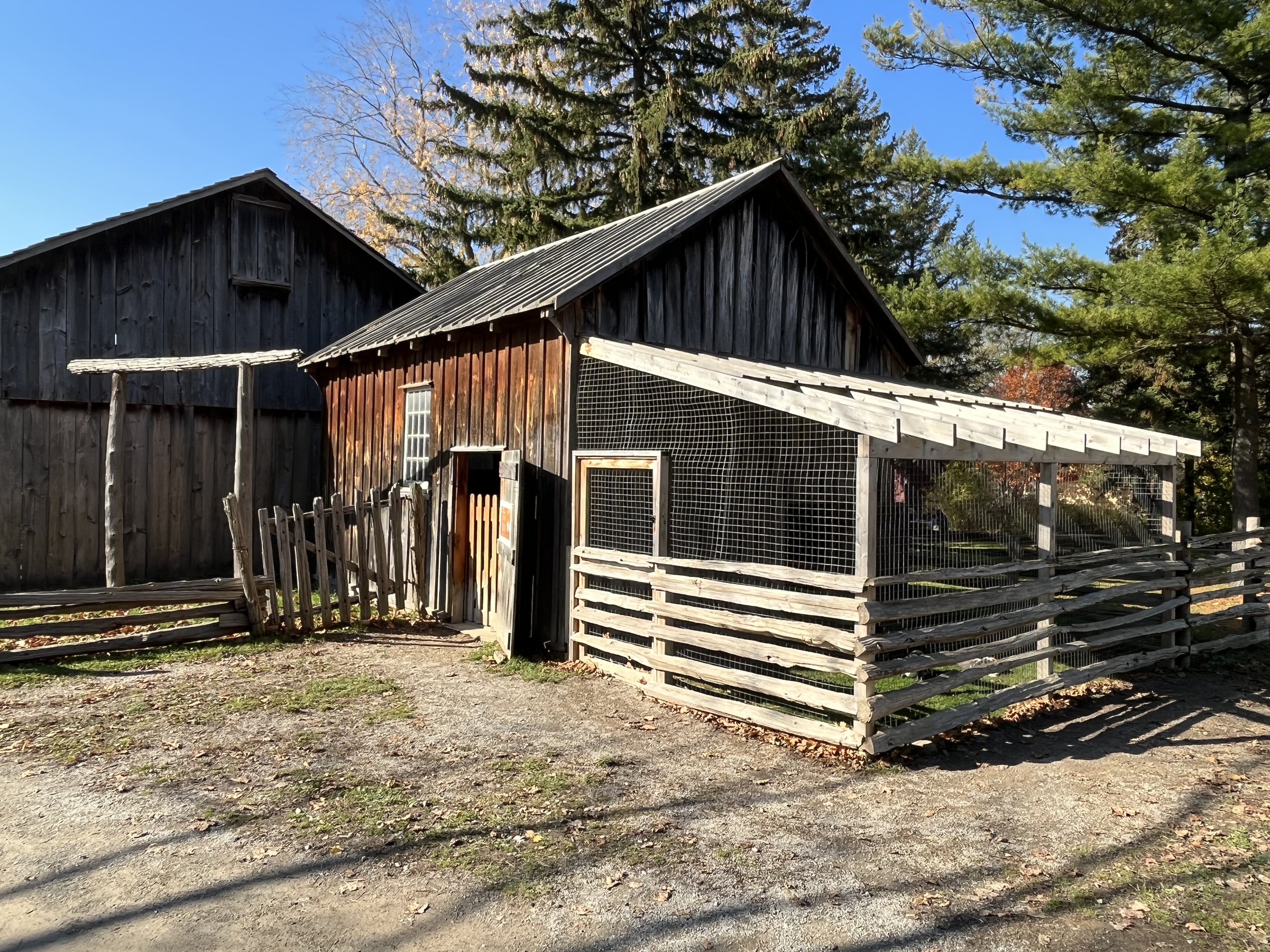
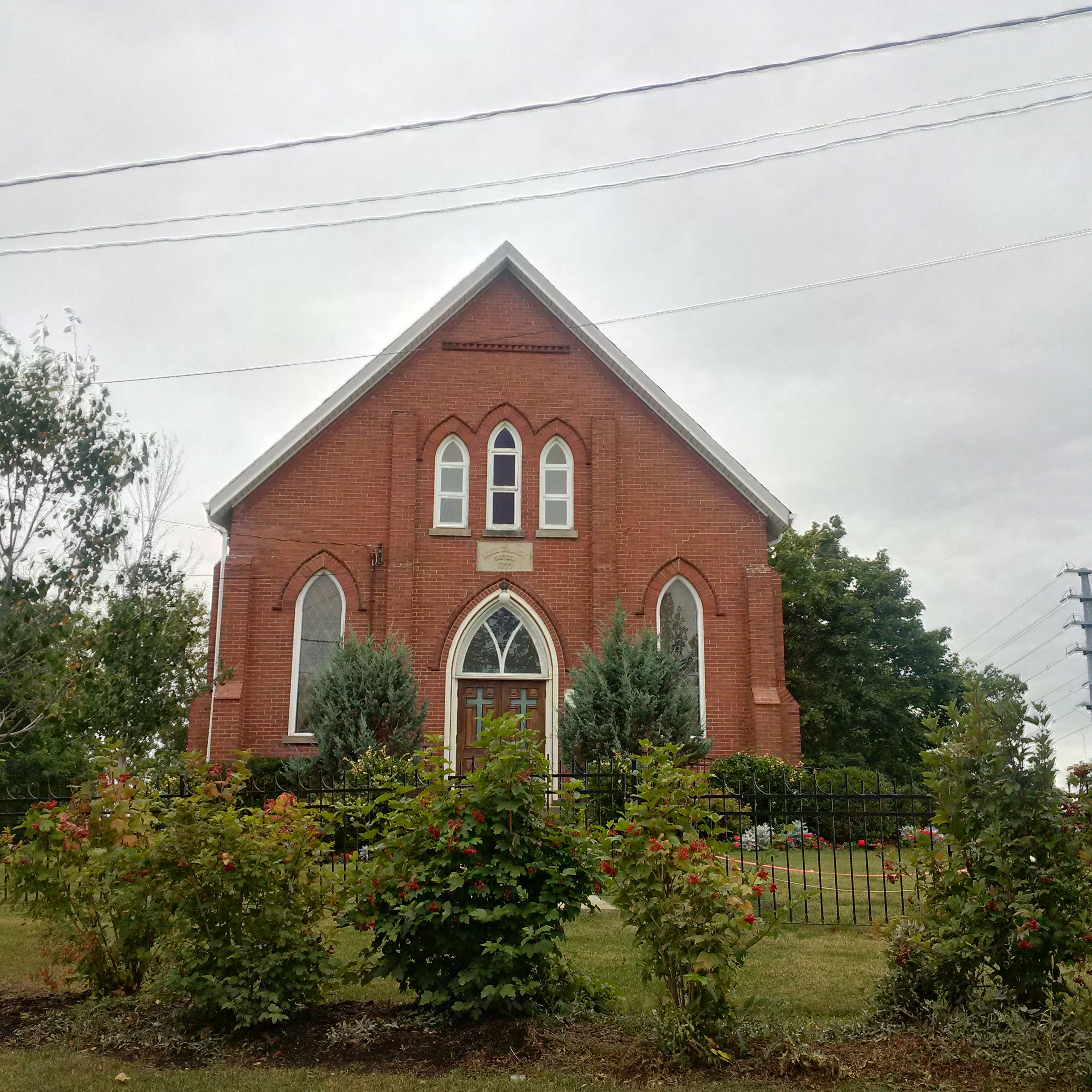
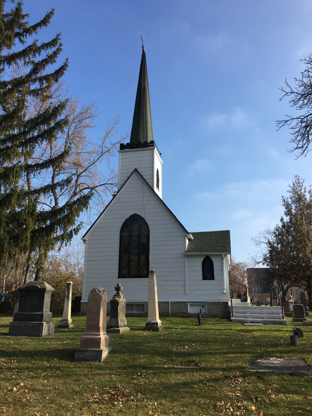
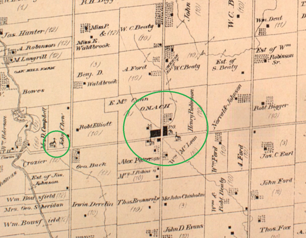
The township of Markham was once dotted with small communities at many of the crossroads. One of these was the hamlet of Cashel which was a little north of the town of Markham. Originally called Crosby’s Corners and then later Fenwick Corners, it took on the name Cashel in 1851 when it got its first post office. In 1866 it was a thriving community of about 100 people that included a sawmill, tavern, shoemaker, tailer, blacksmith, broom maker, 2 inns and a Masonic Temple. One of these inns still stands at the intersection of modern Kennedy Road and Elgin Mills Road but most of the other businesses have disappeared. There are still a number of houses that survive from this era but most are empty, waiting while the farm land around them is developed for housing. One of the most prominent sites in the former community is now home to the Markham Fairgrounds, across the street from the Peach United Church featured below.

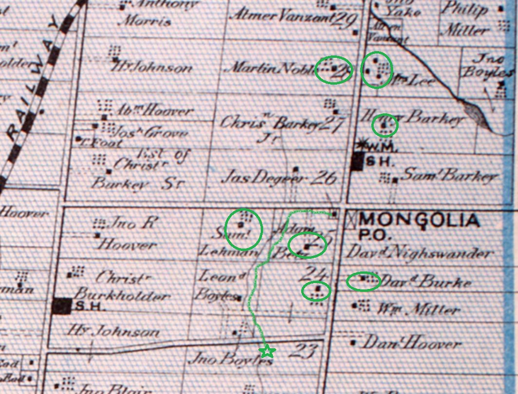
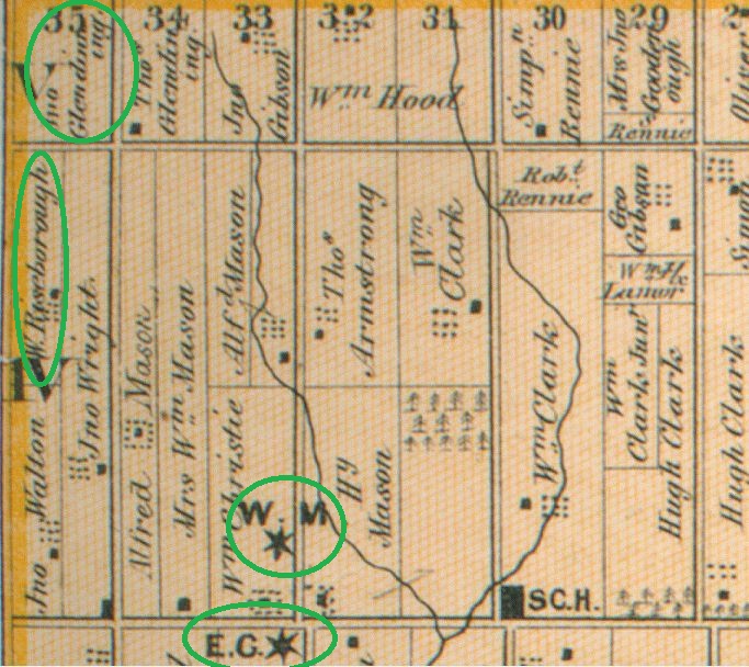
The 1877 County Atlas shows the location of some of the remaining buildings, including the ones featured in the story below. Just north of the intersection is a green star which marks the location of the Presbyterian cemetery. By the time of the atlas below, the church was no longer there.

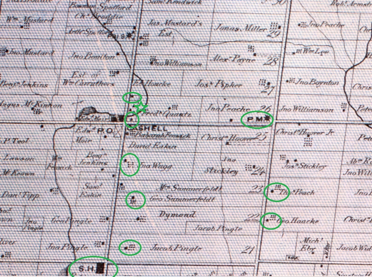
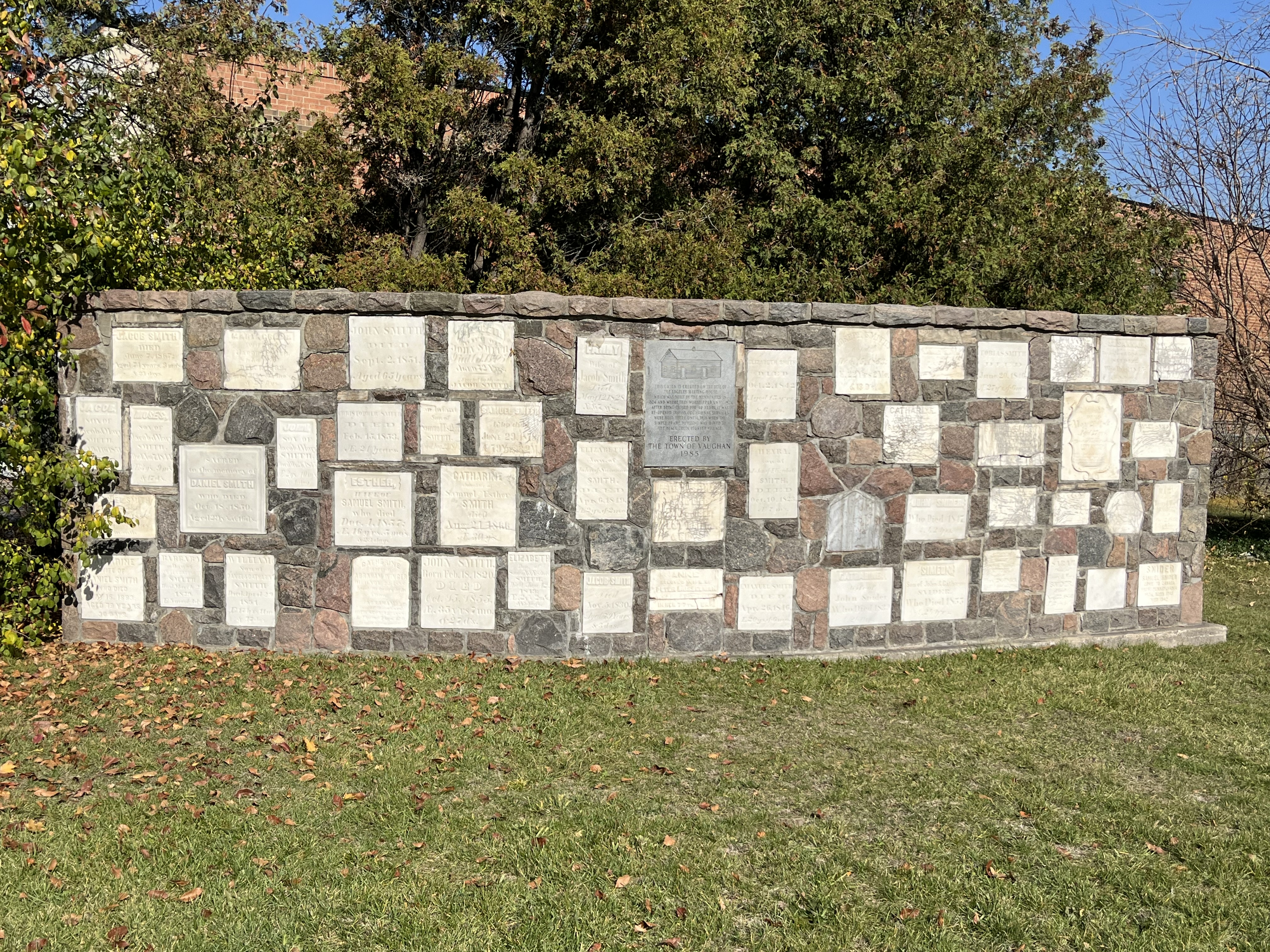
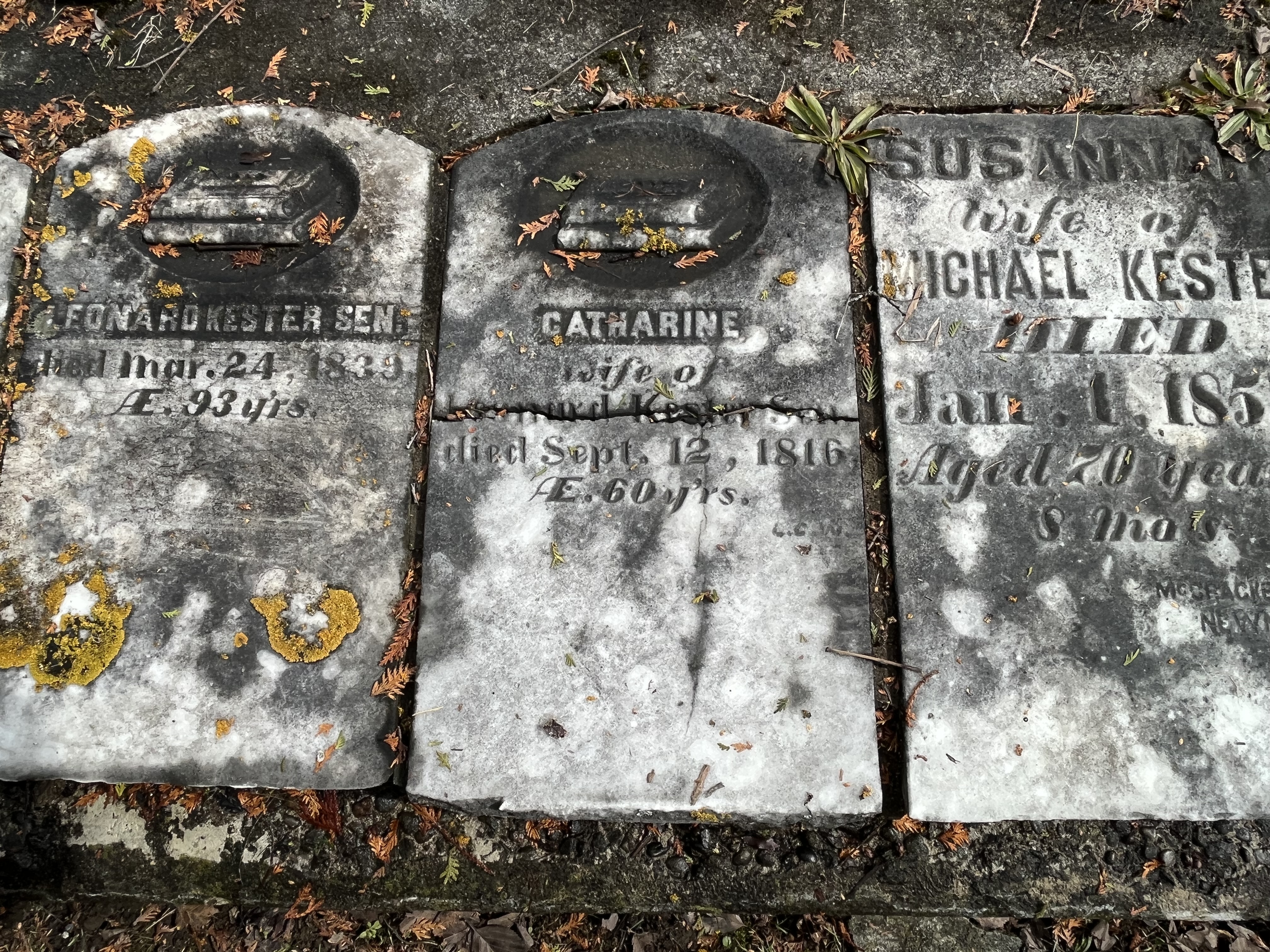
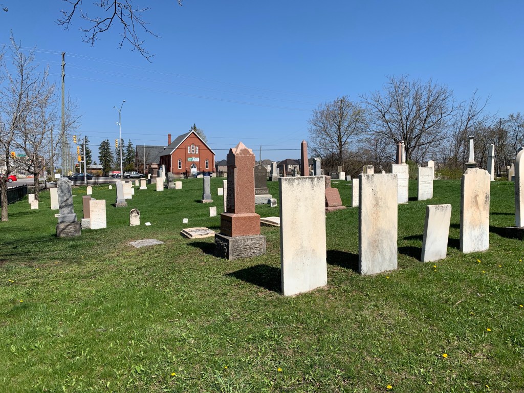
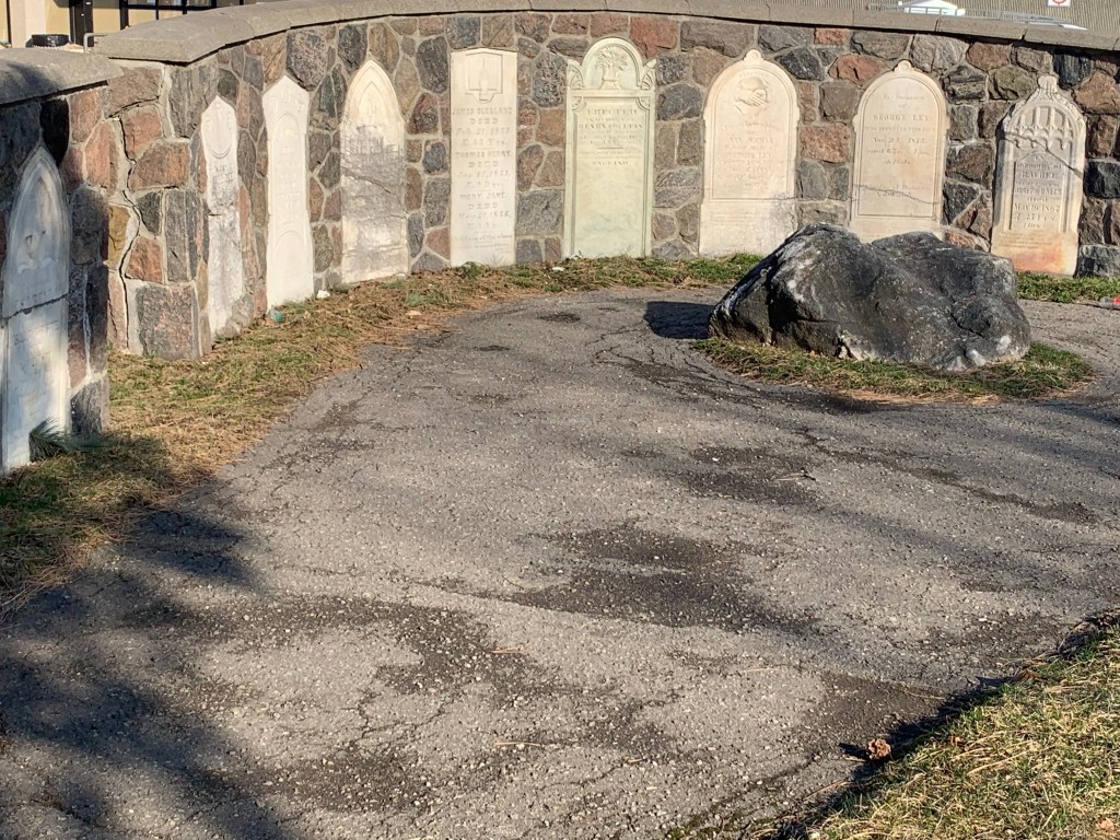
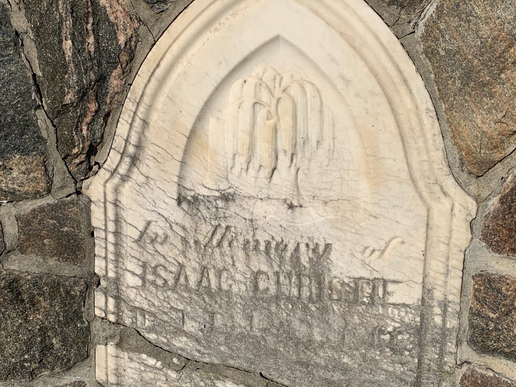
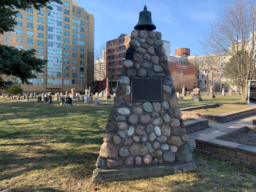
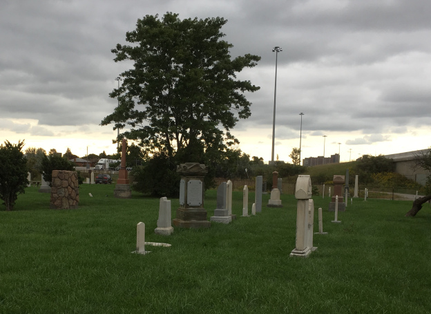
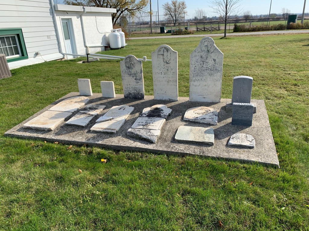
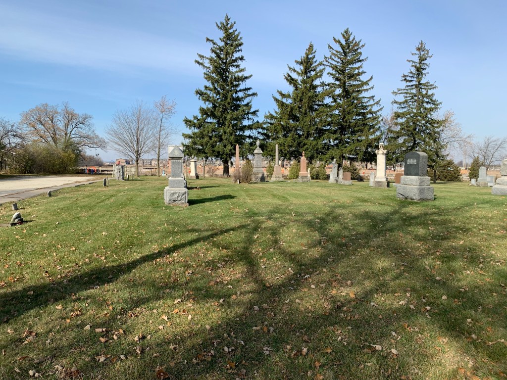
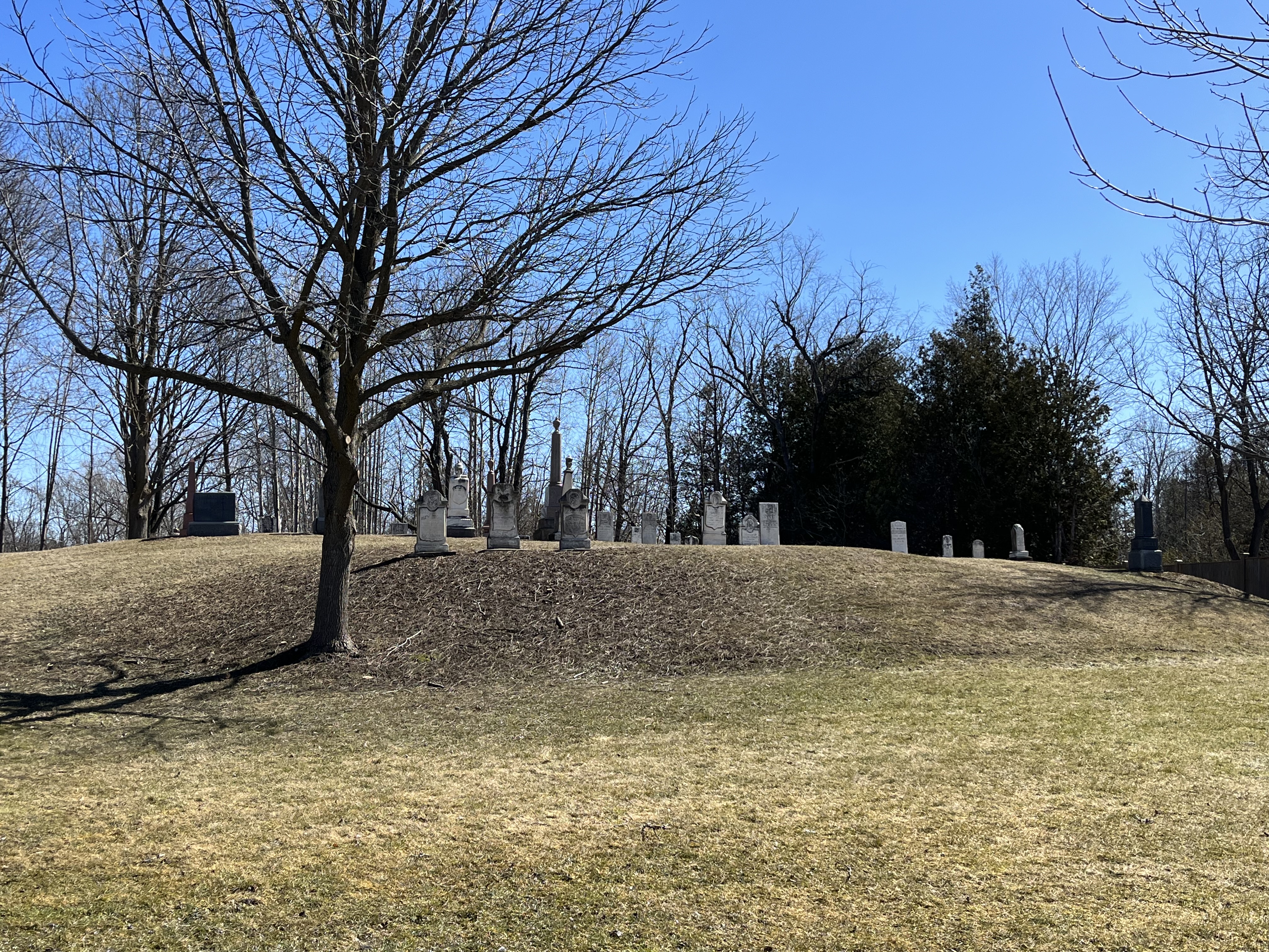
St. Helen’s Presbyterian Church developed a graveyard in 1827 behind the building. The church operated until about 1865 and then was left without a congregation. The cemetery is now known as Cashel Cemetery and since the church has been demolished the cemetery is maintained by the City of Markham. Many of the township’s earliest settlers were buried in this cemetery.

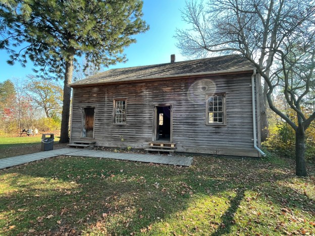
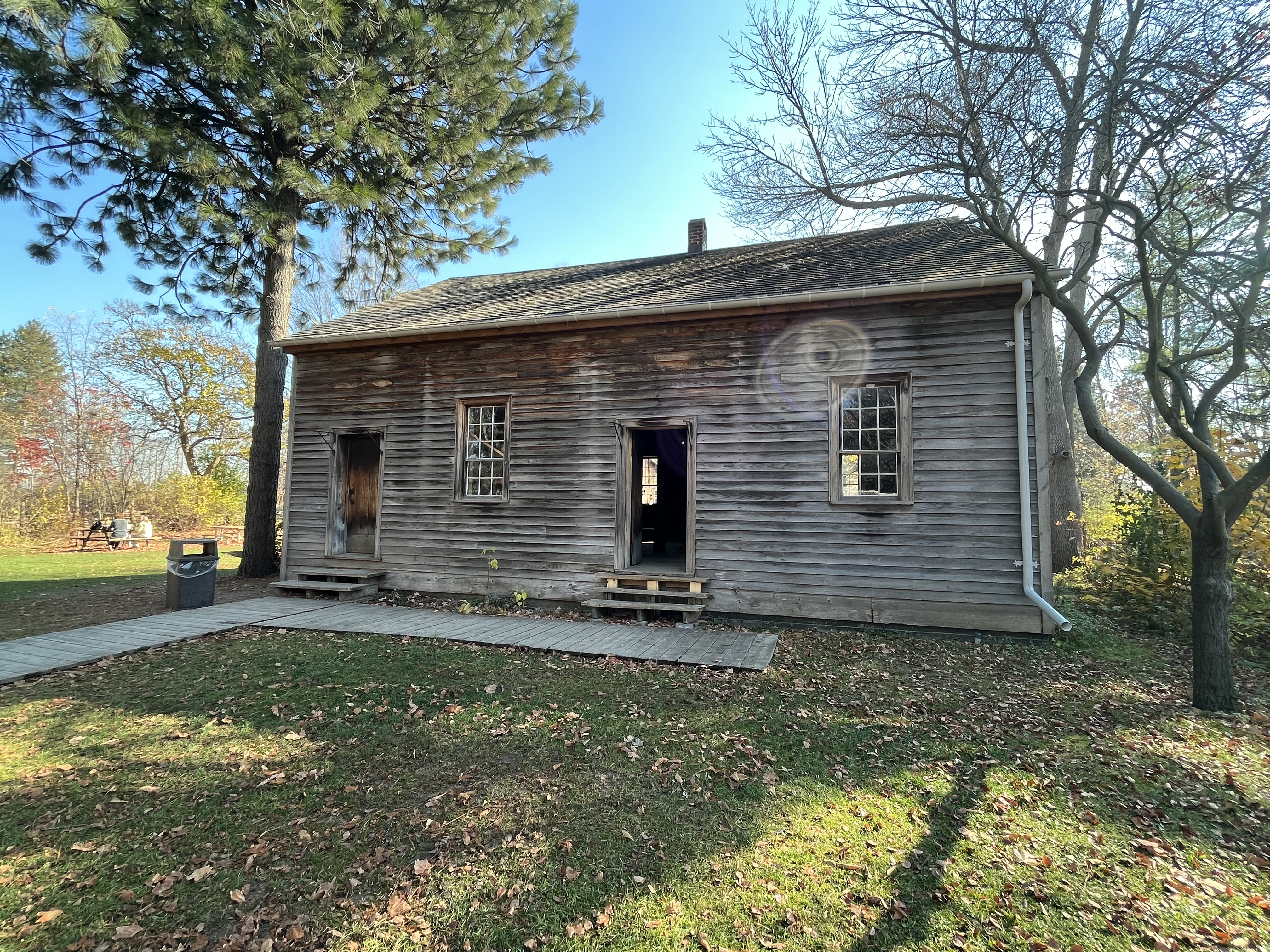
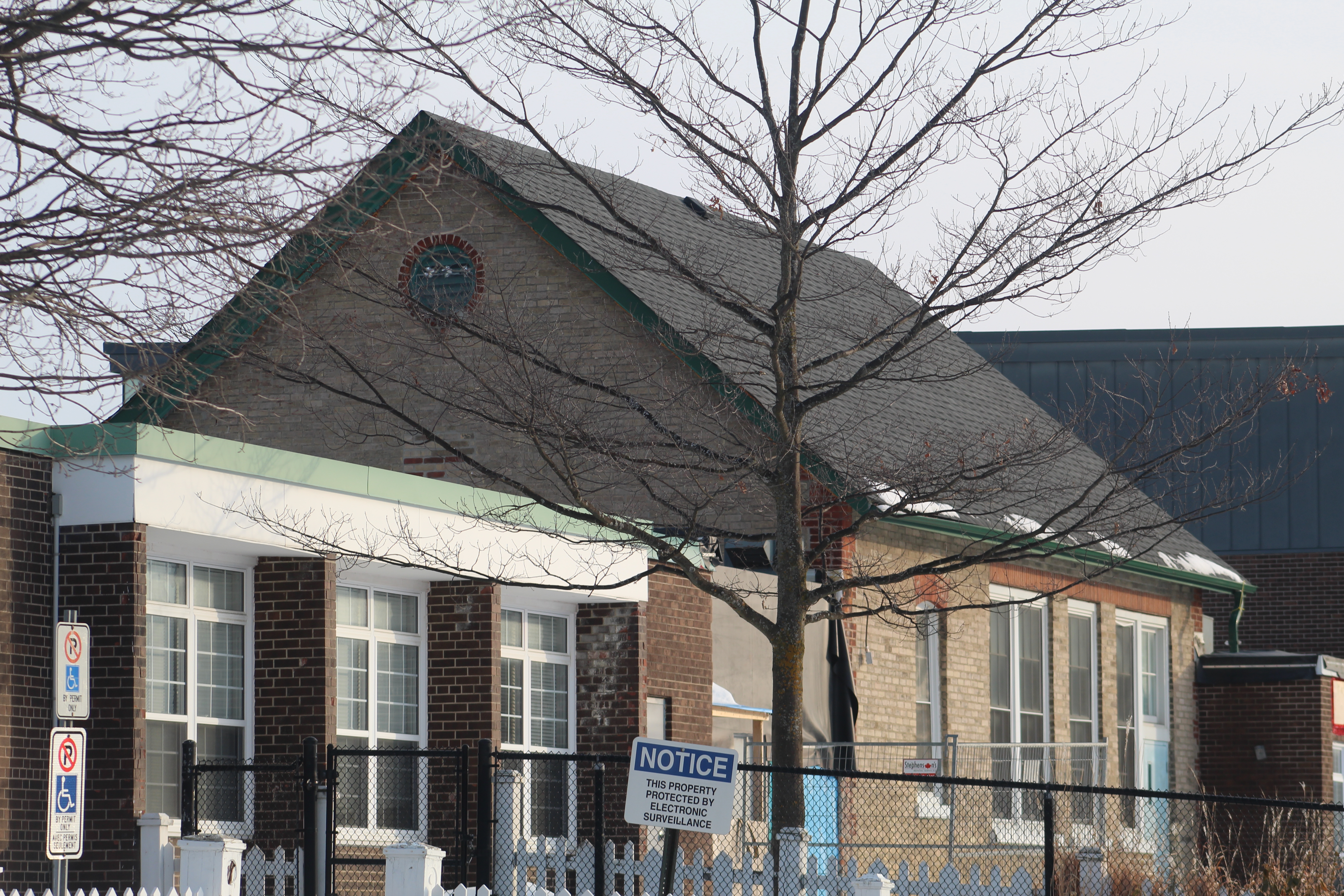
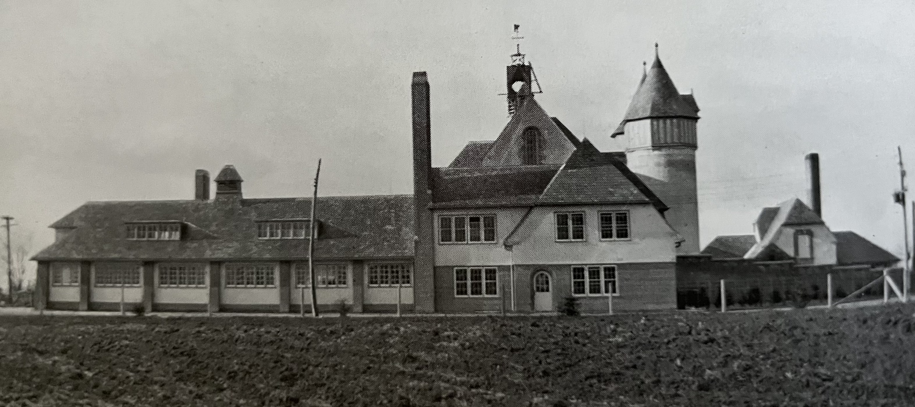
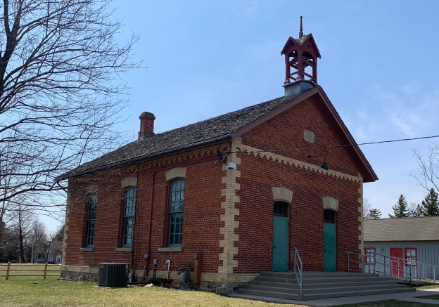
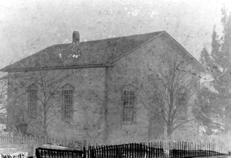
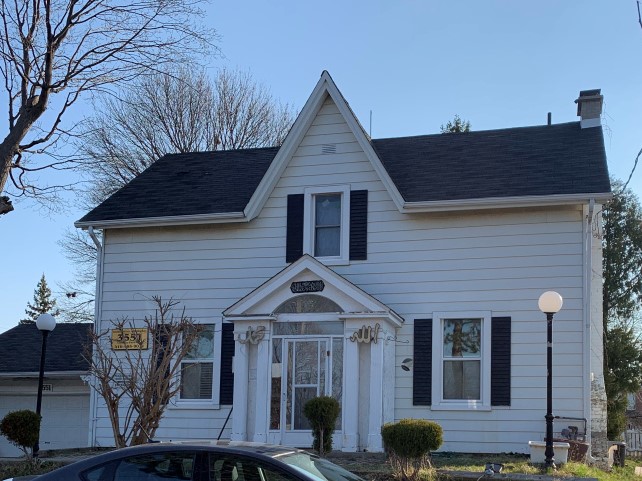
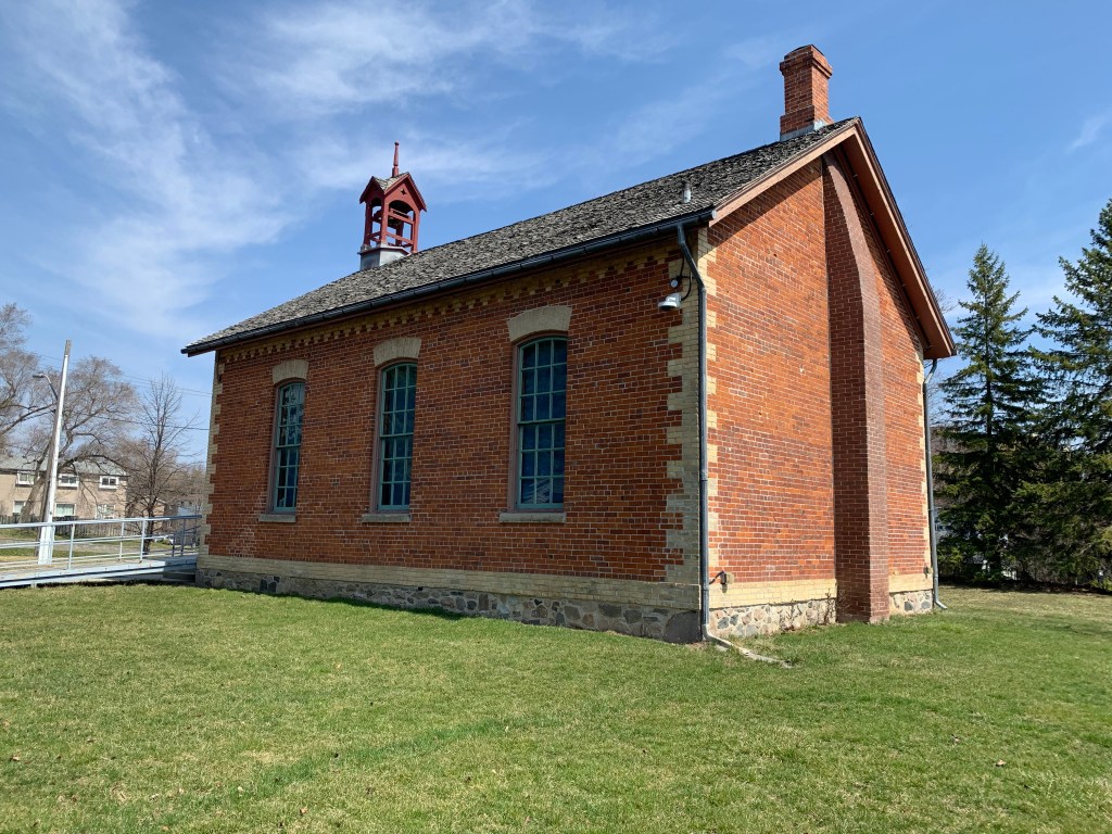
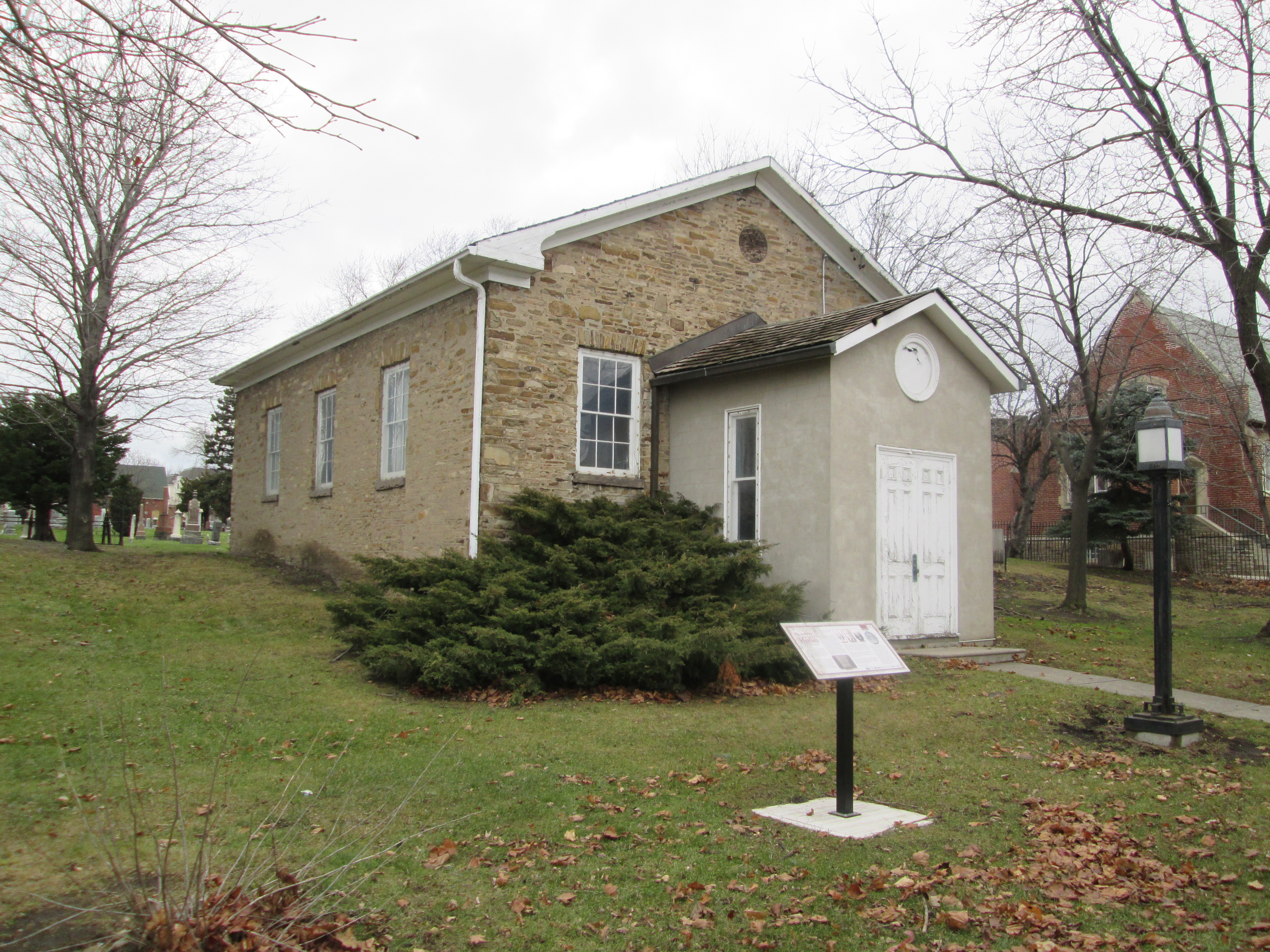
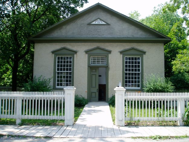
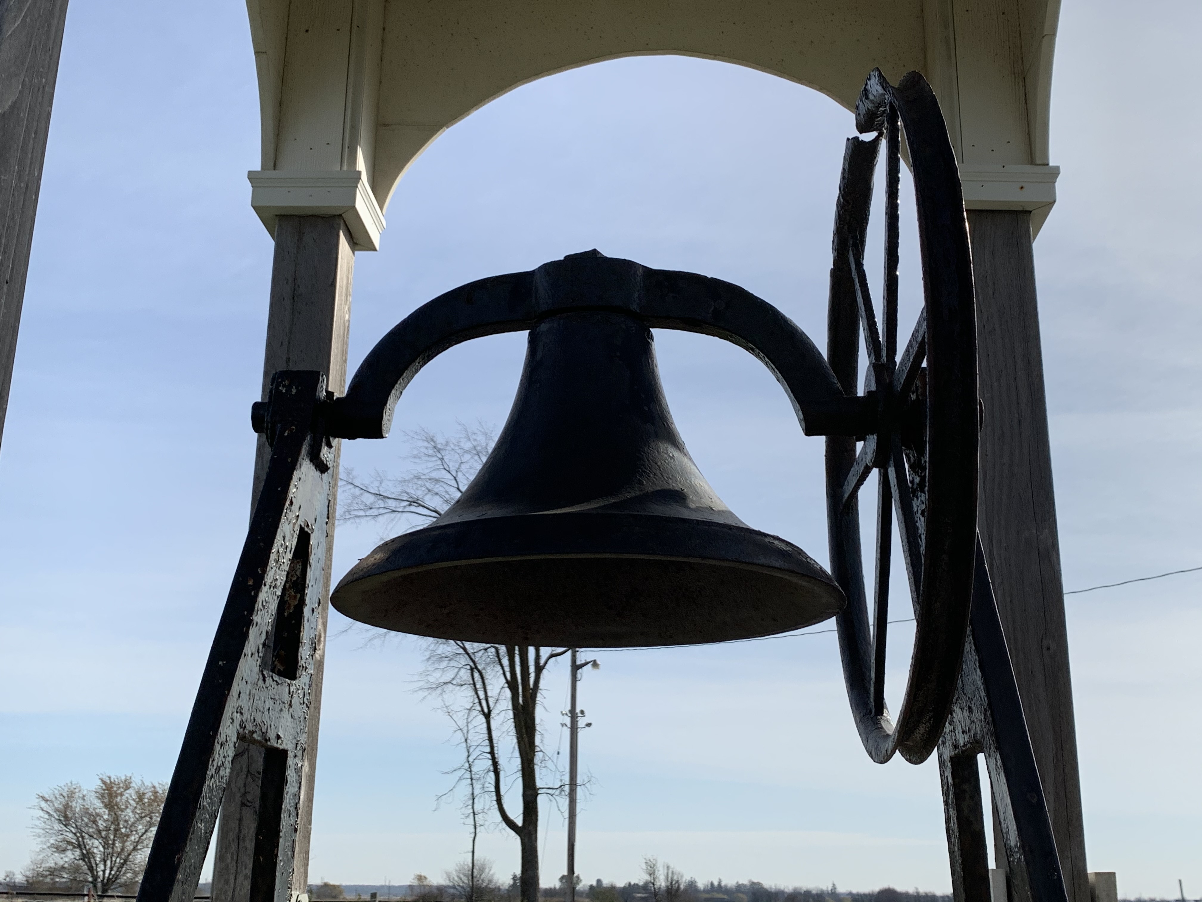
The original school house was built in 1837 and by 1850 there were about 40 students in attendance in the one room building. School Section 11 of Markham was replaced in 1862 with a new brick building with two front doors. One for the boys and one for the girls. At some point a veranda was added to the front and one of the doors was sealed off. The building was restored when the surrounding land was developed for a plaza and the veranda was removed.

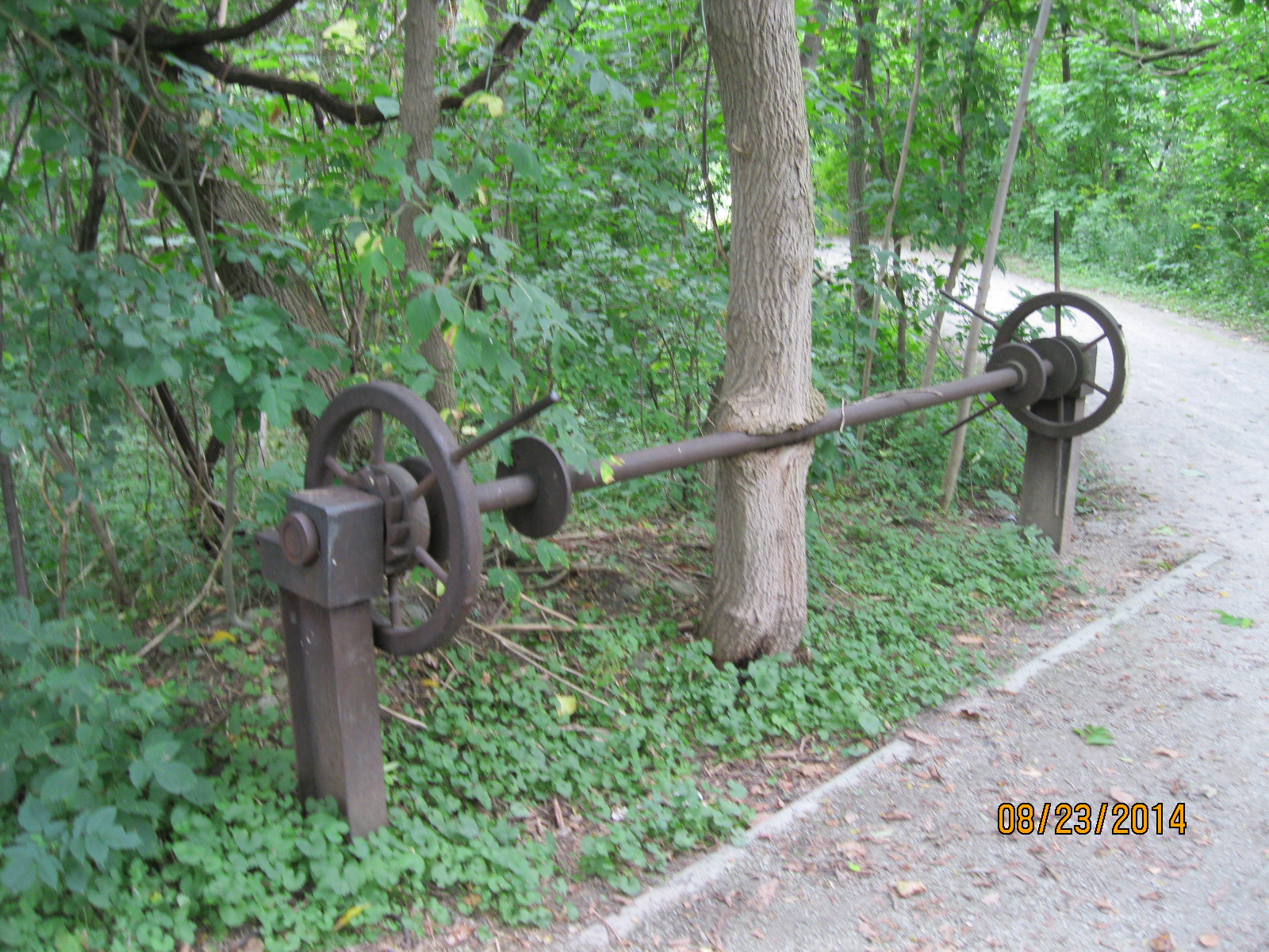
The school still has the bell that once called students into classes but it appears to be stuck in an unusual position. It looks as if it is in permanent action, calling students who never actually show up anymore.

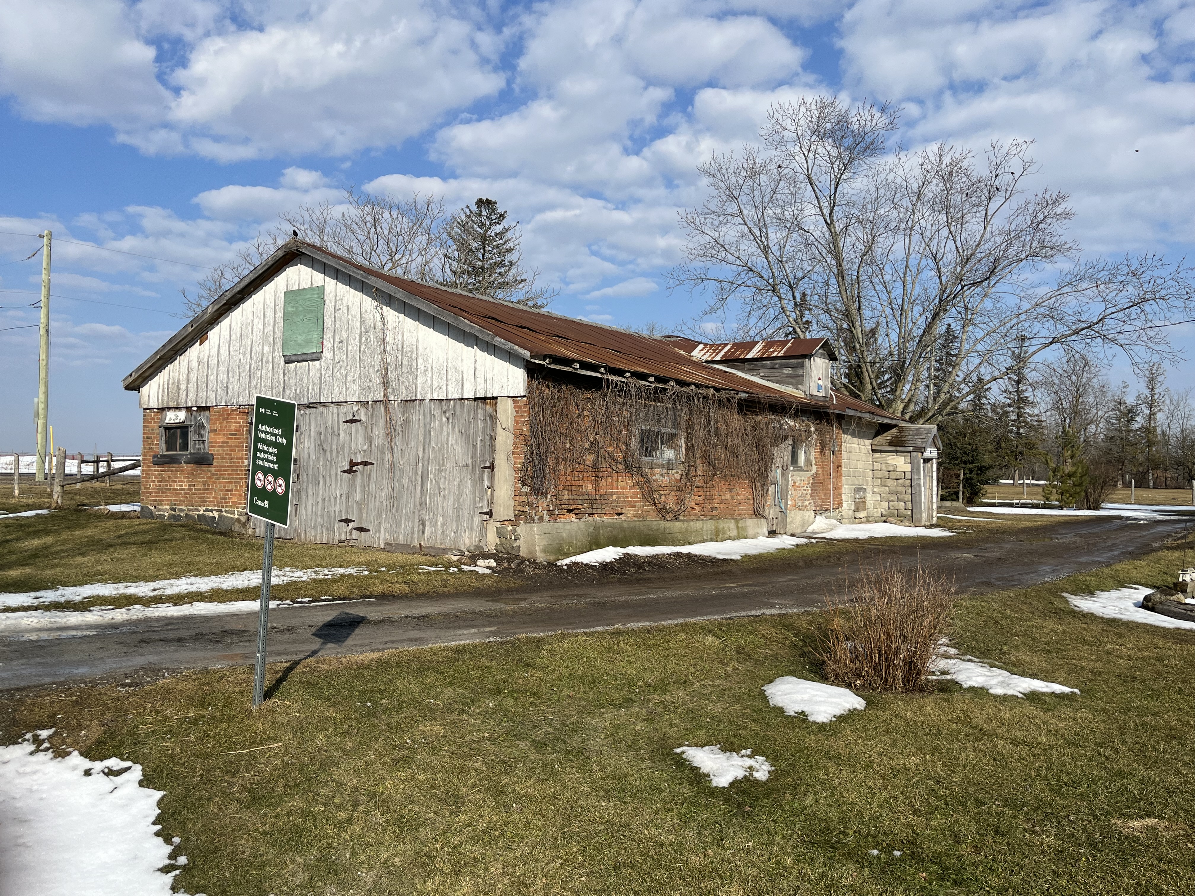
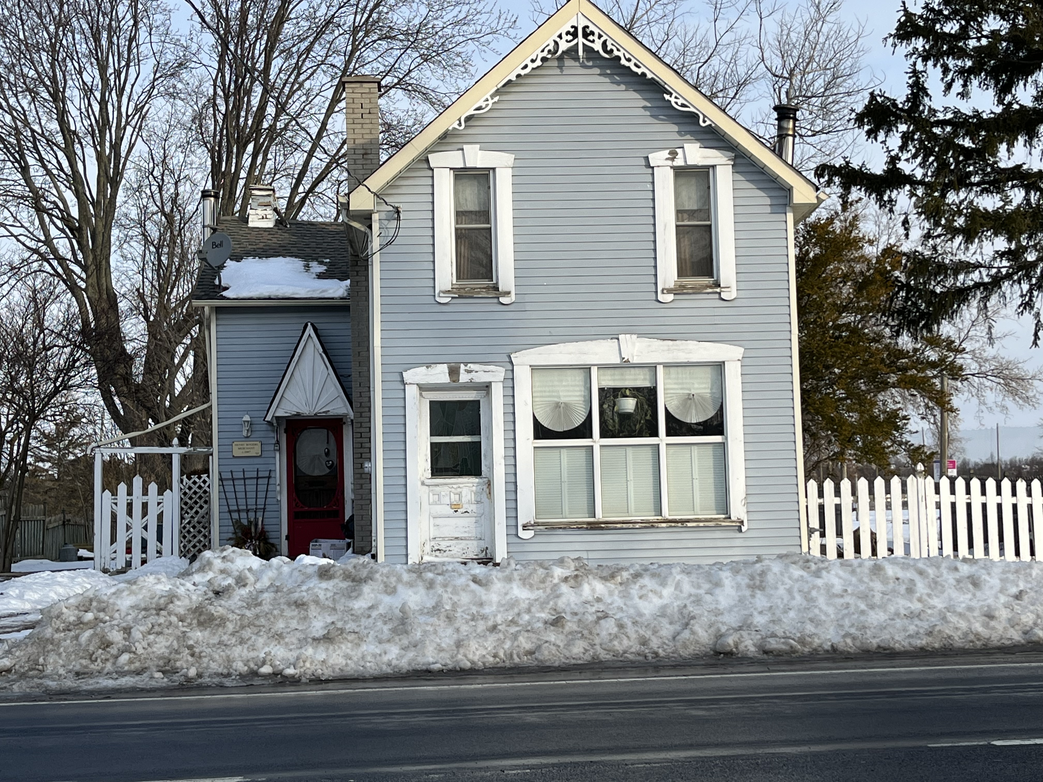
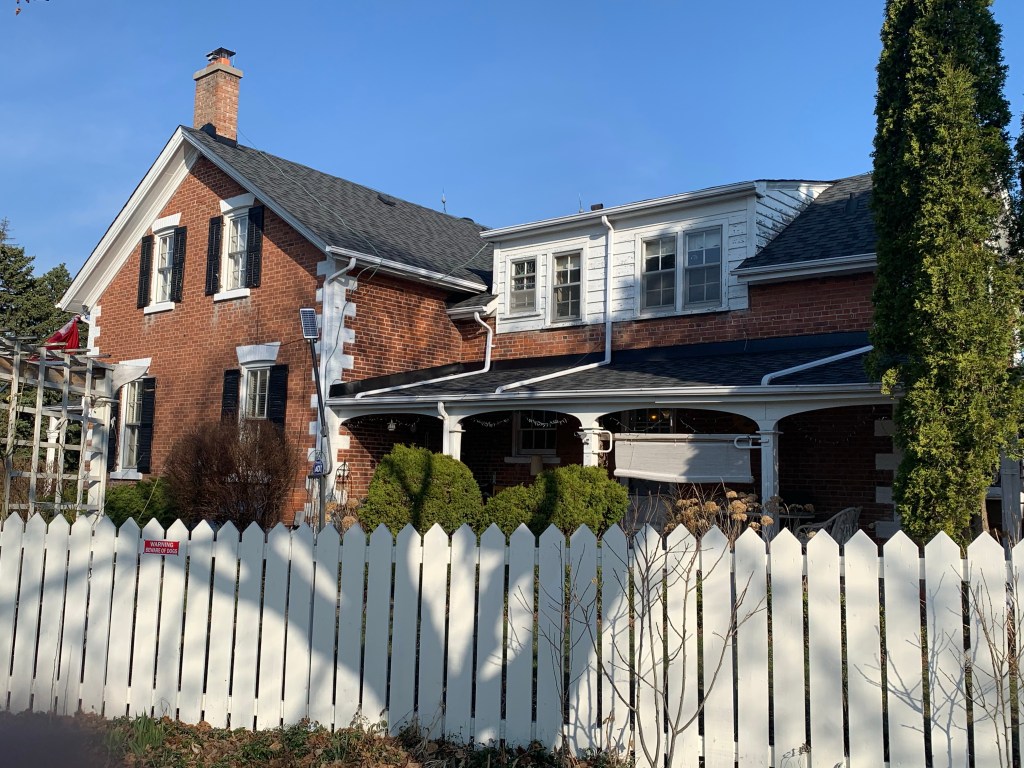
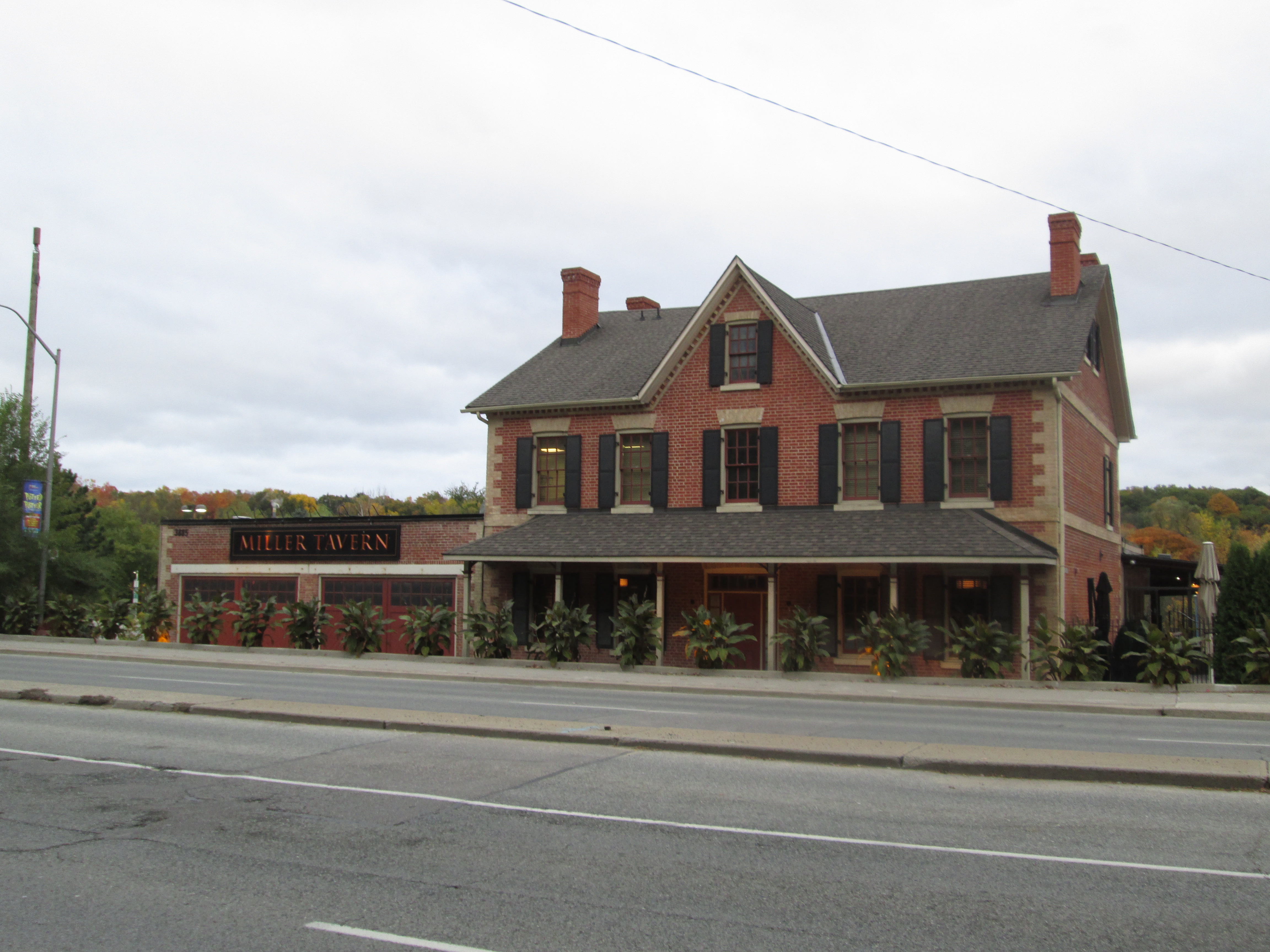
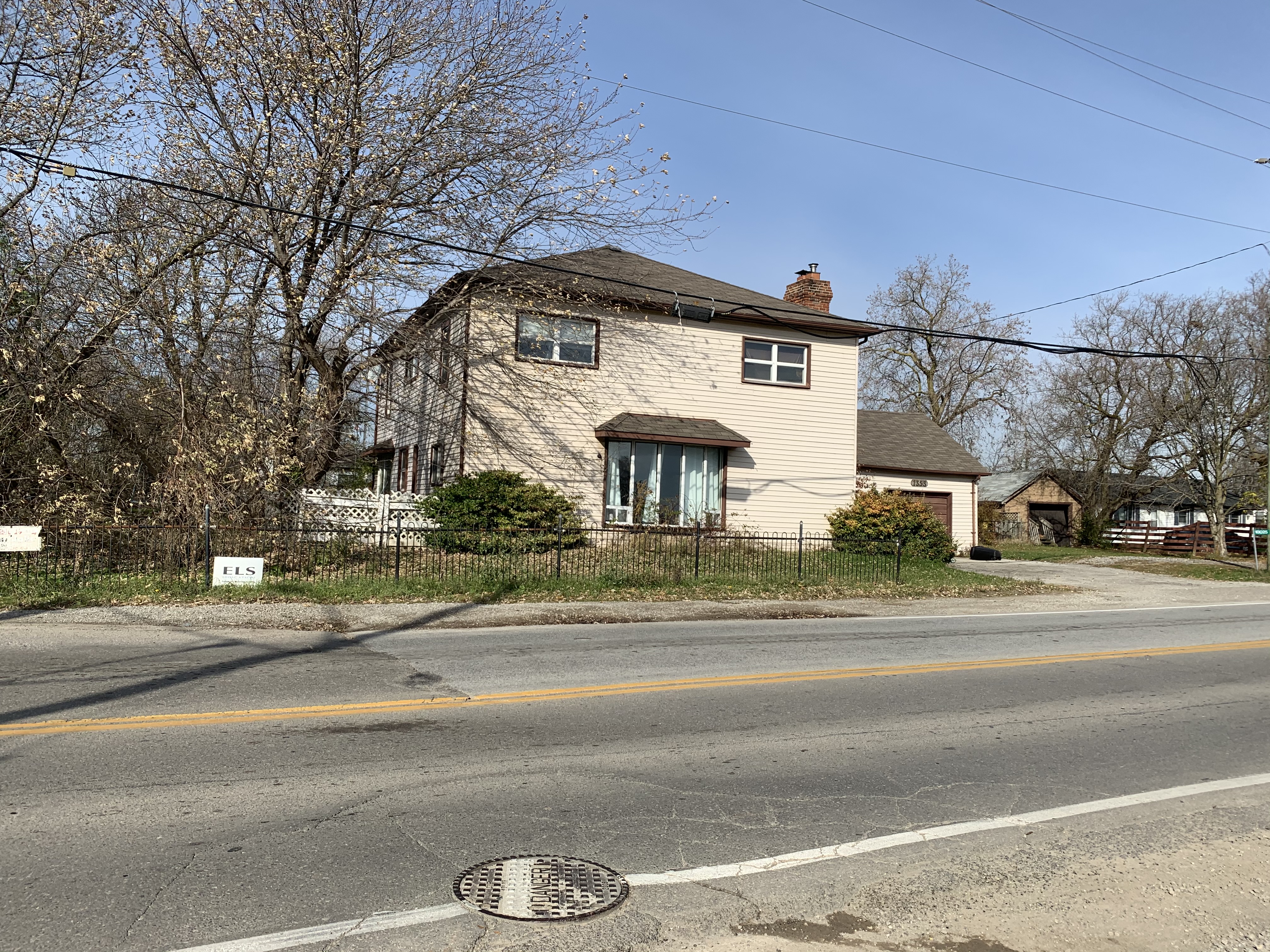
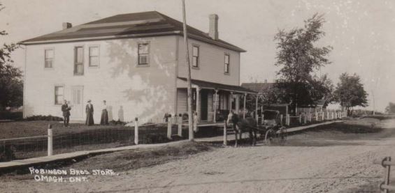
One of the two inns in town is still standing but is now a private residence. The inn was constructed in 1835 and was initially named Llandon Plains Hotel. For awhile it served as the Cashel store and post office and in recent years was Bates Roadhouse Antiques.

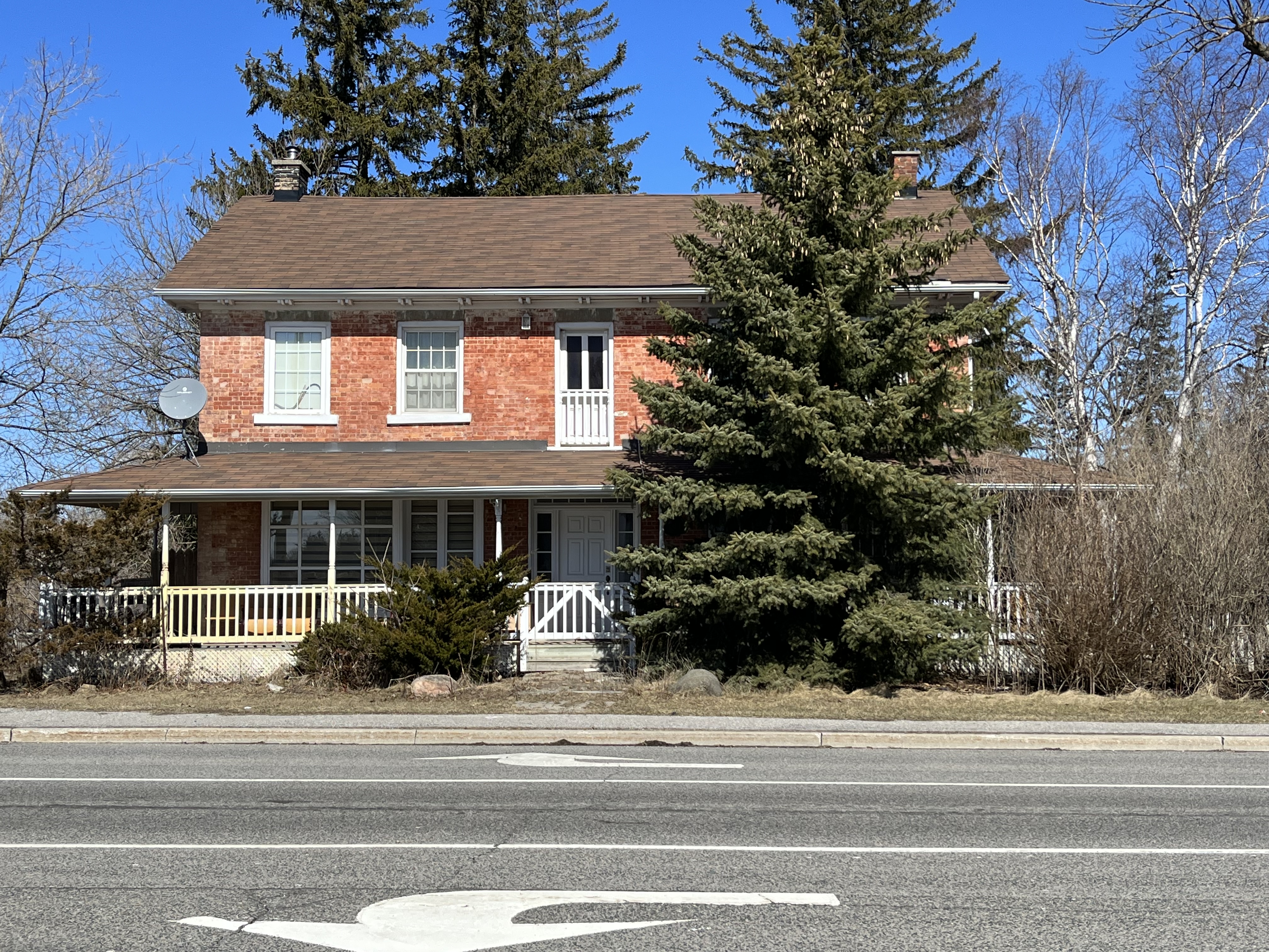
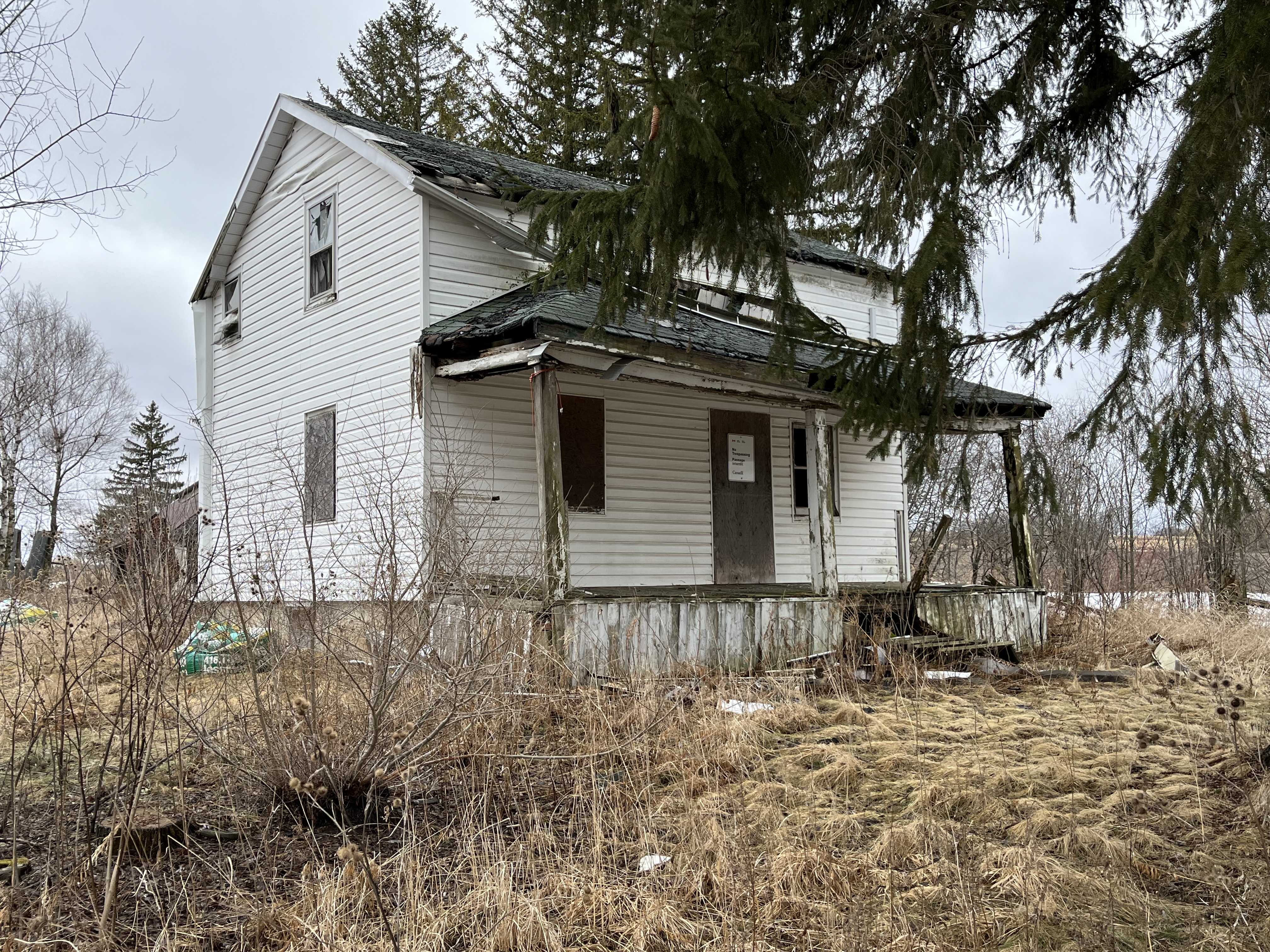
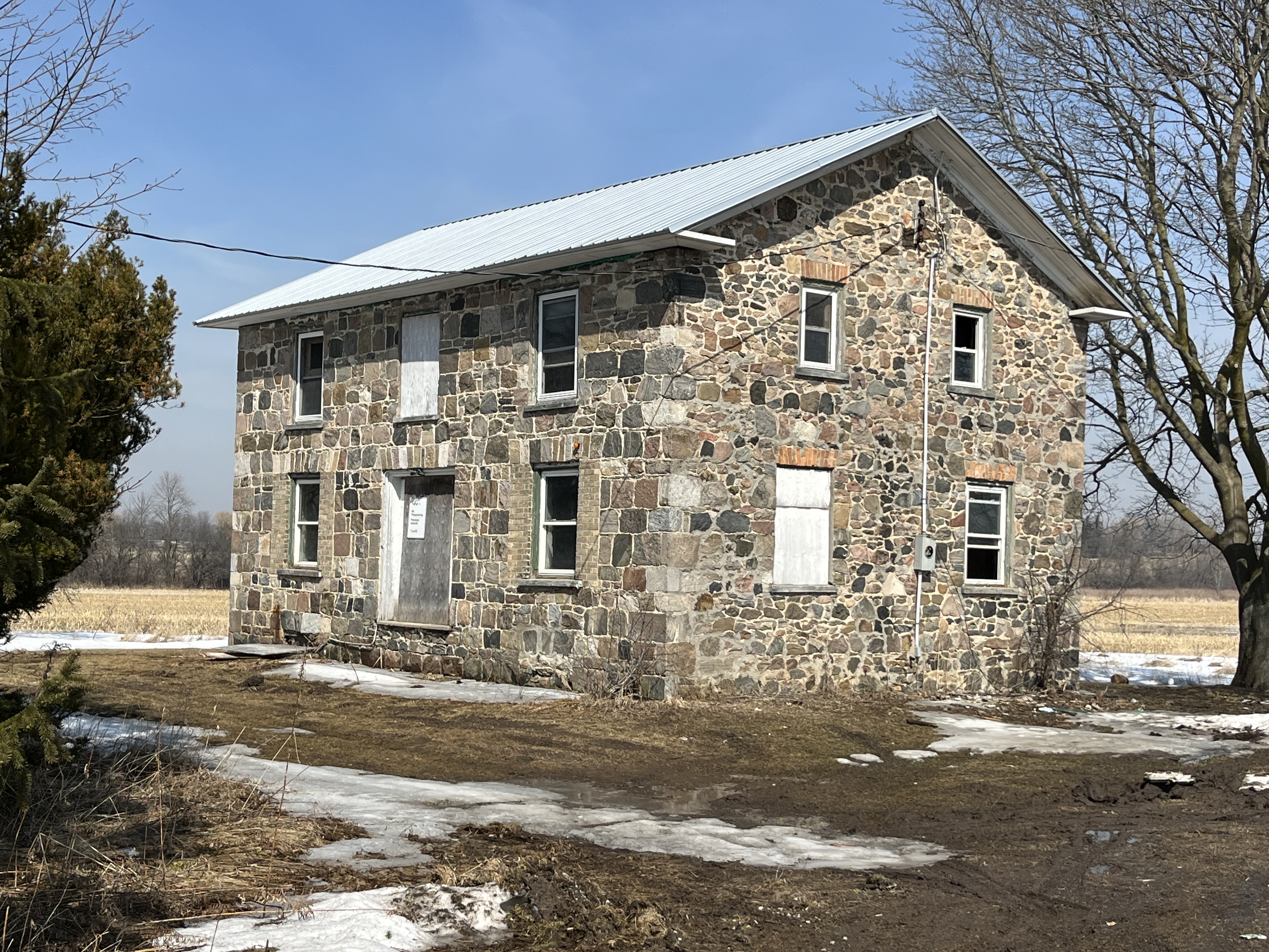
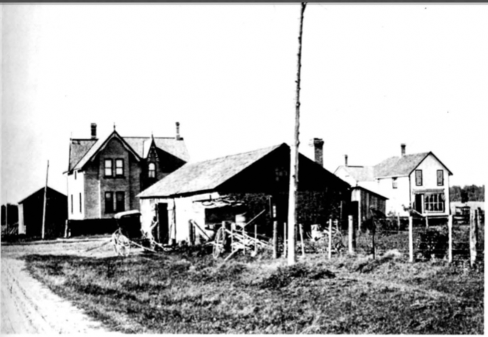
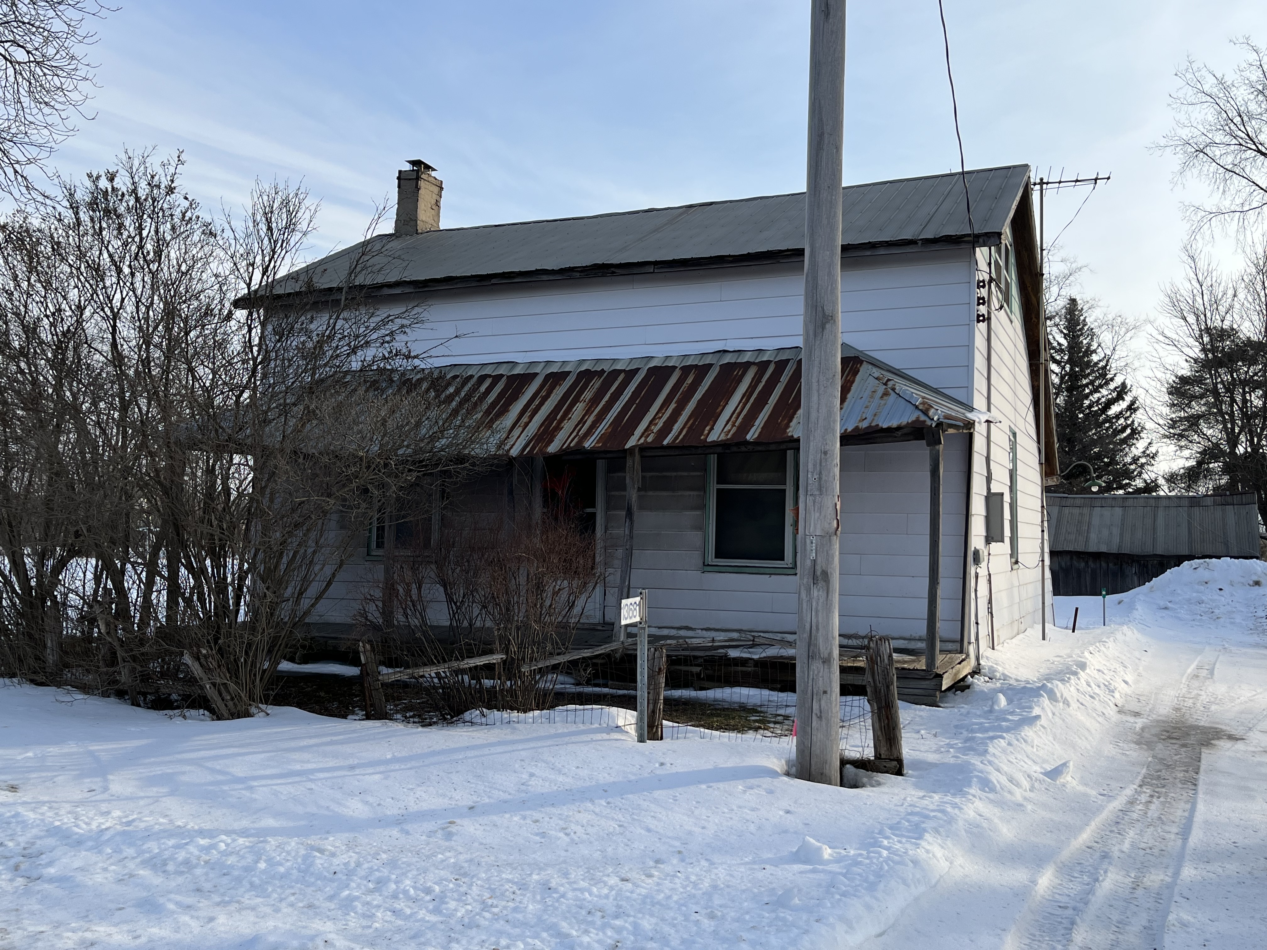
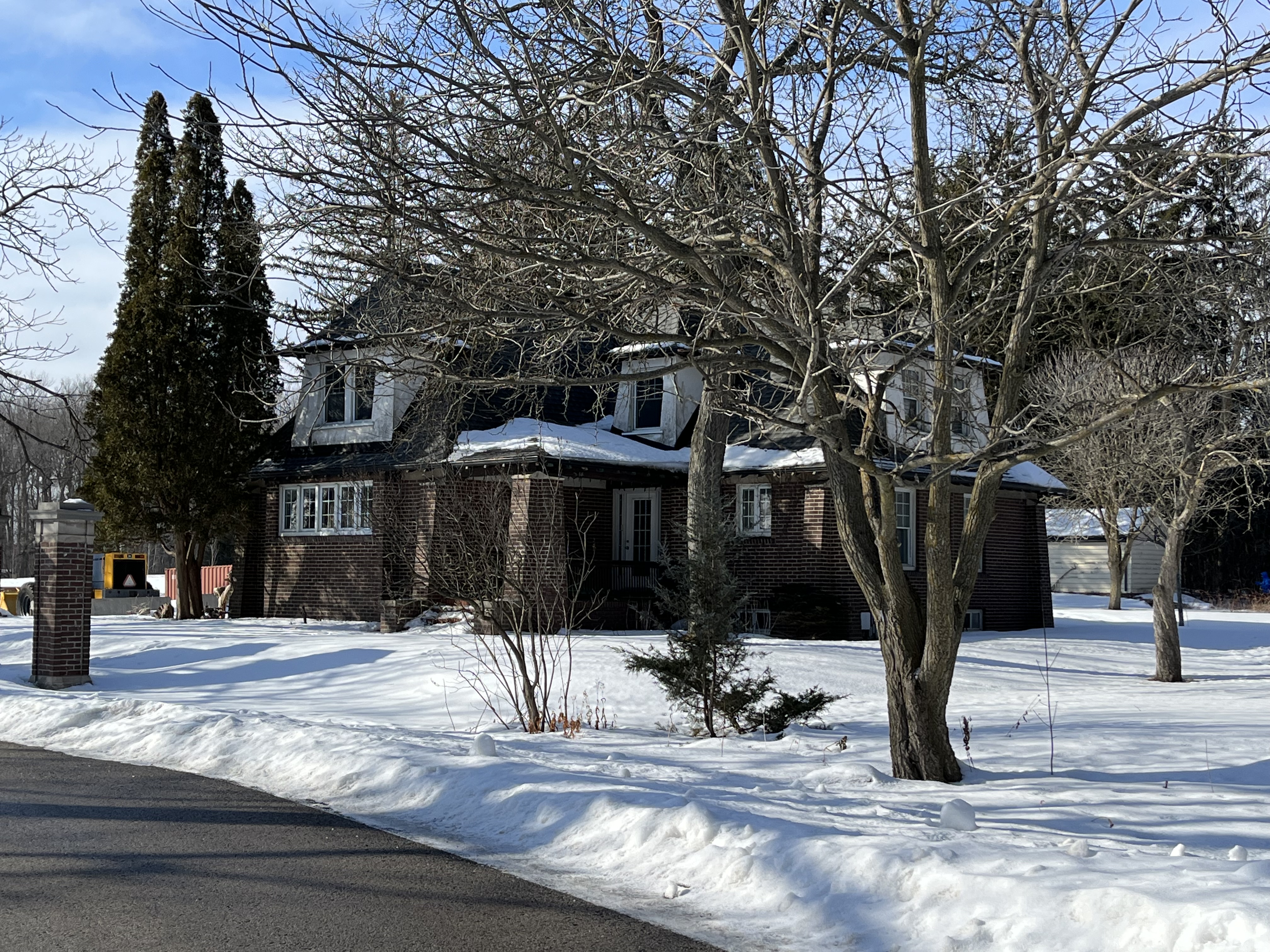
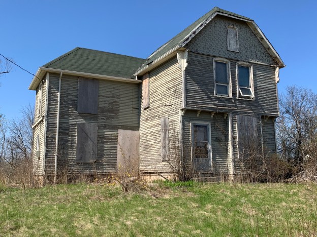
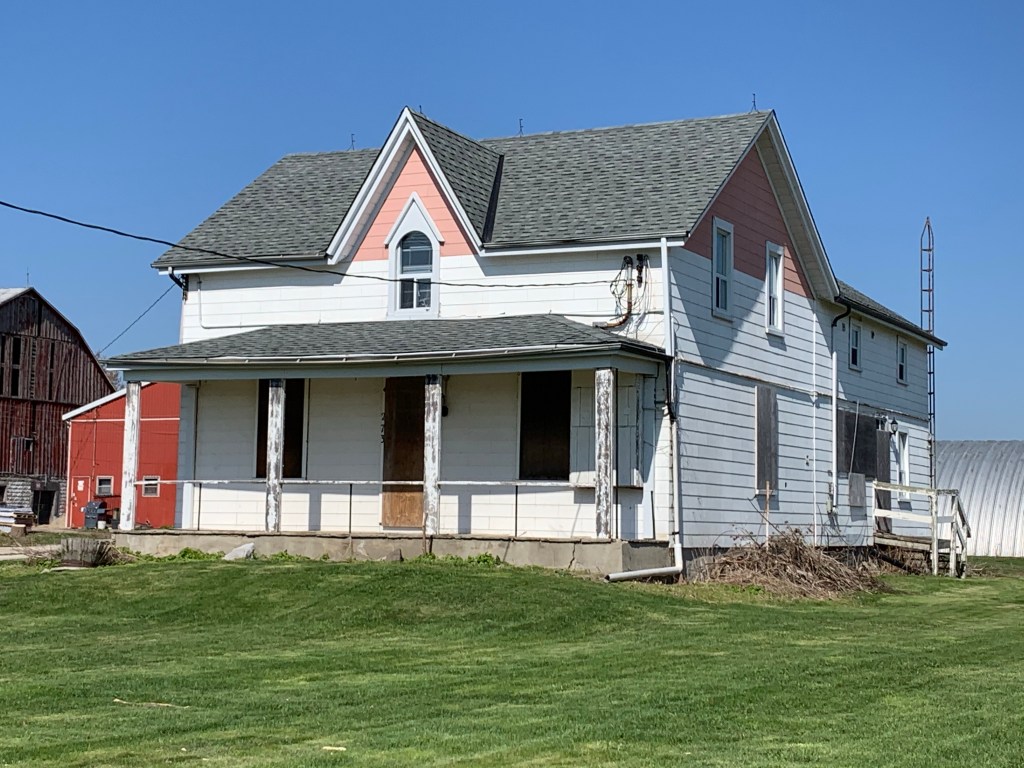
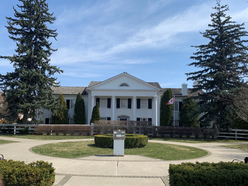
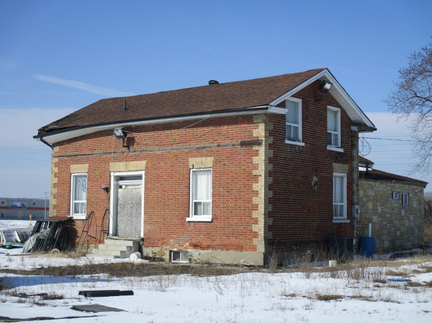
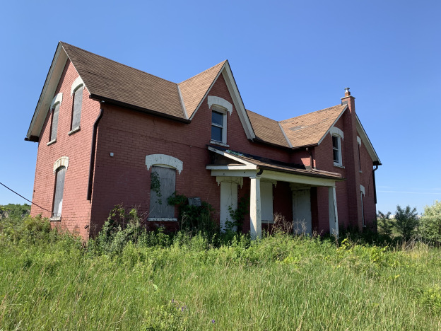
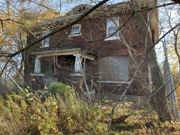
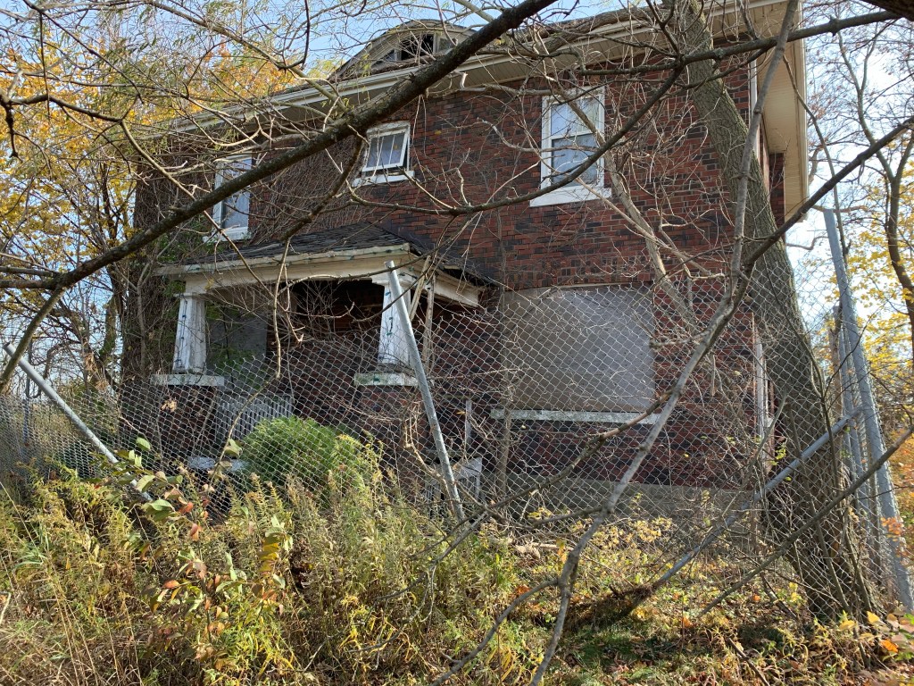
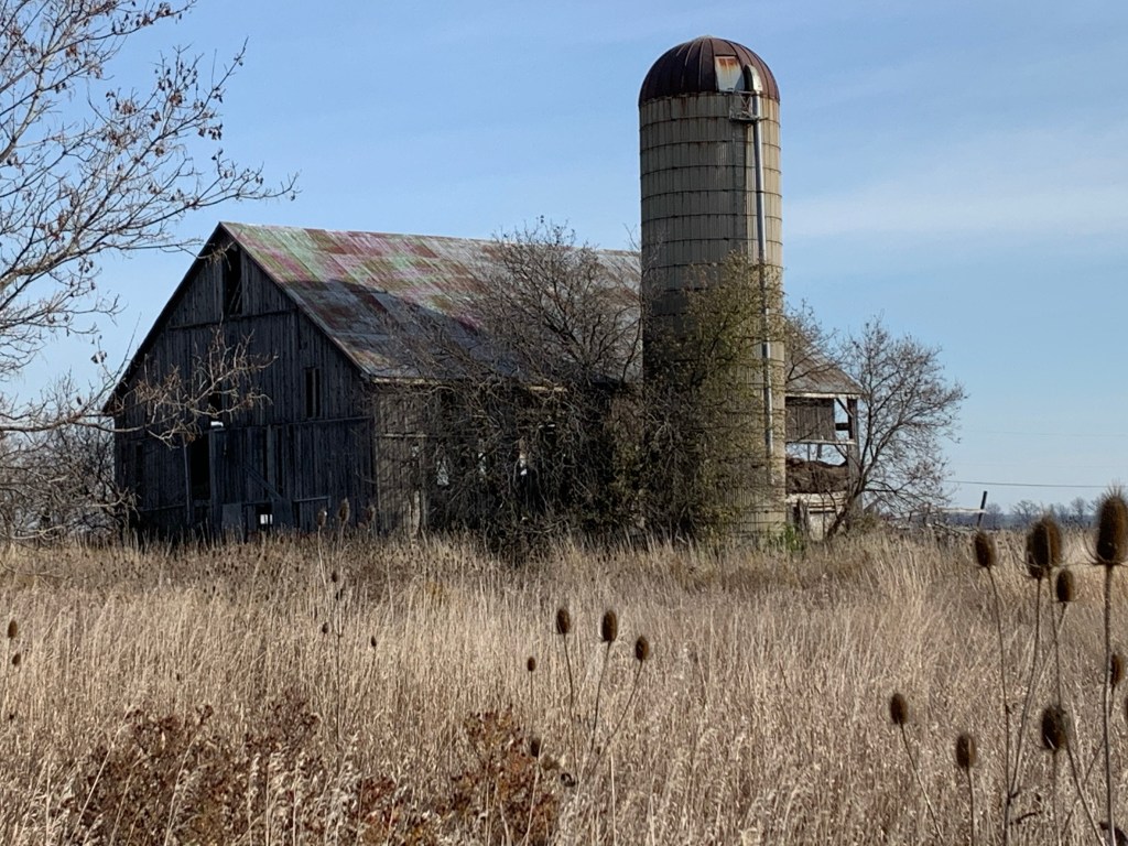
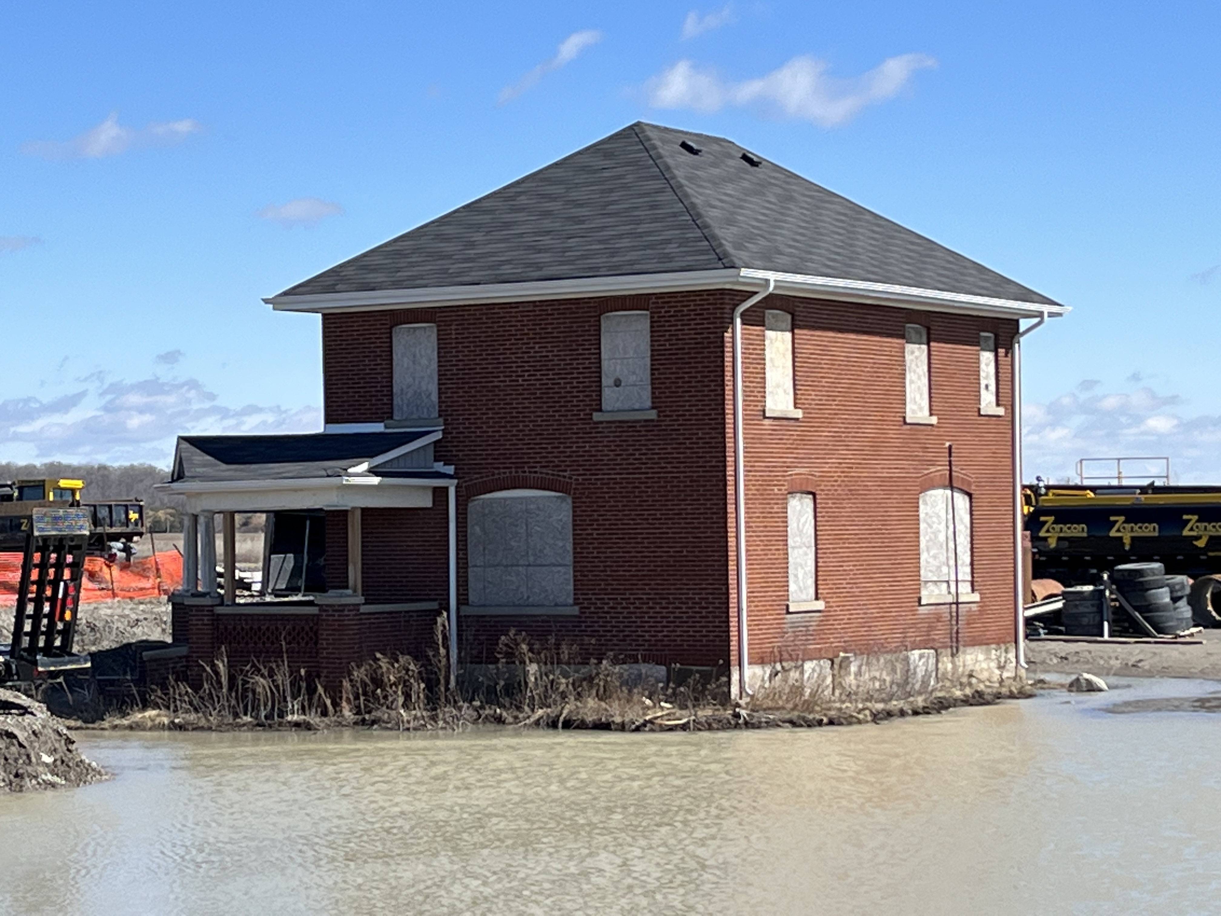
The original settlers named Pingle sold their farm in 1881 to Samuel and Mary Wilson. Their son Homer took over running the farm in 1890 and became the owner in 1894. Around 1900 he had a new brick farmhouse built on the property where he lived until he sold to John Preston “JP” Carr in 1926. The Carrs had a son Albert who took over the farm in 1950.

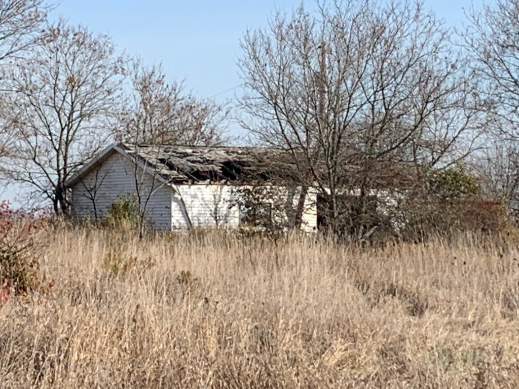
When JP Carr retired from farming in 1950 he had a small cottage built in the front yard of the earlier farm house. He lived here with his wife Florence.

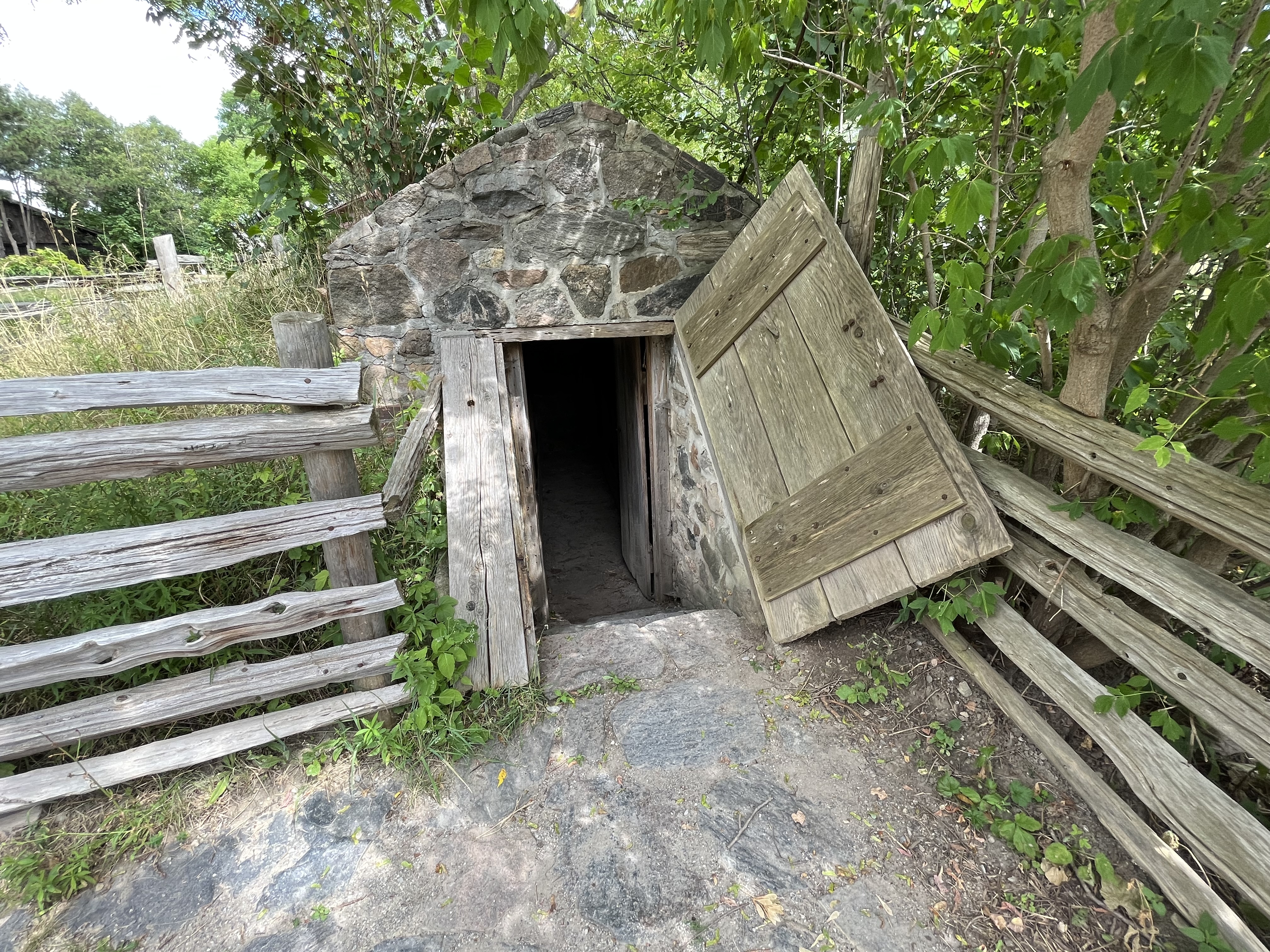
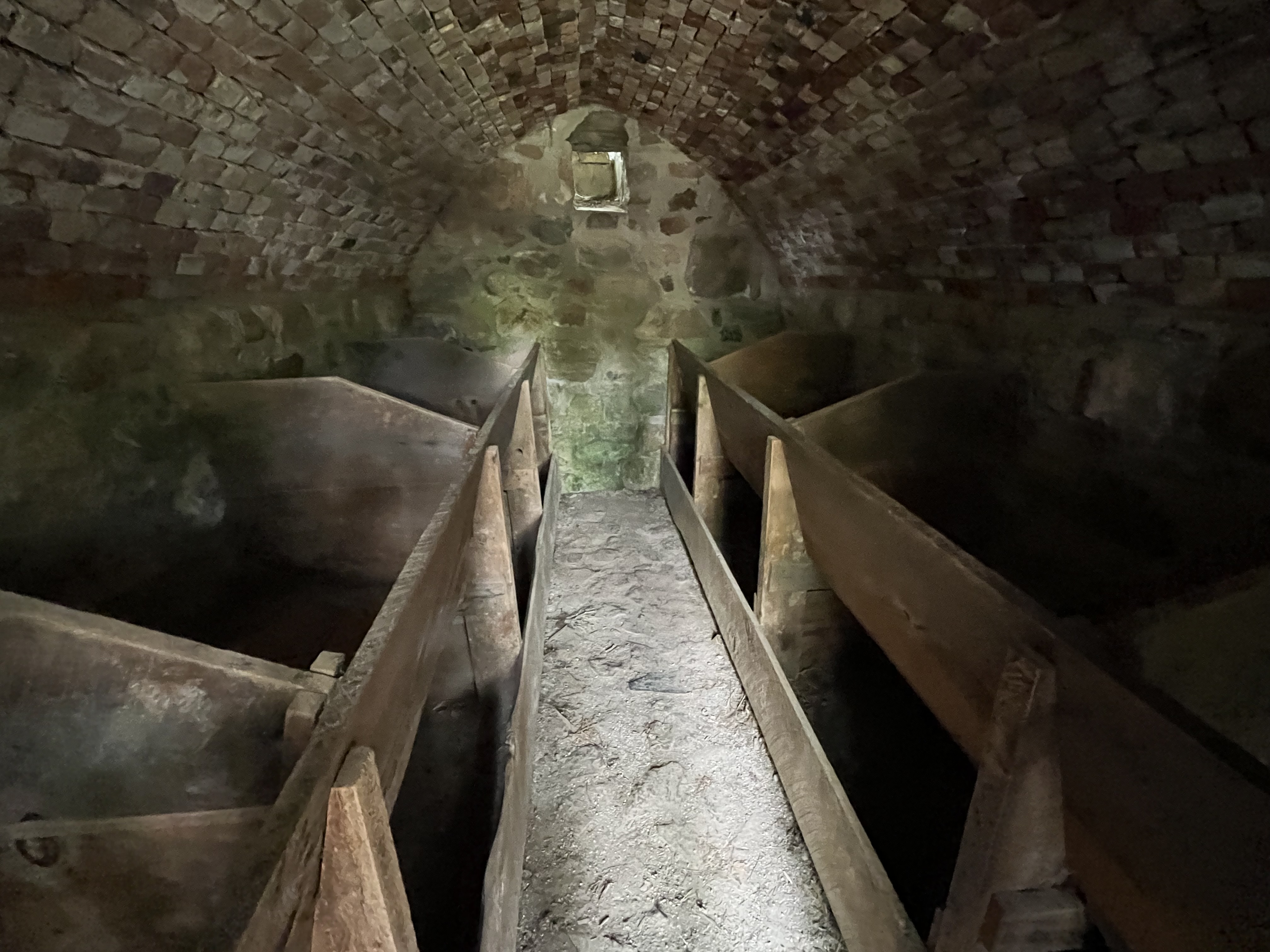
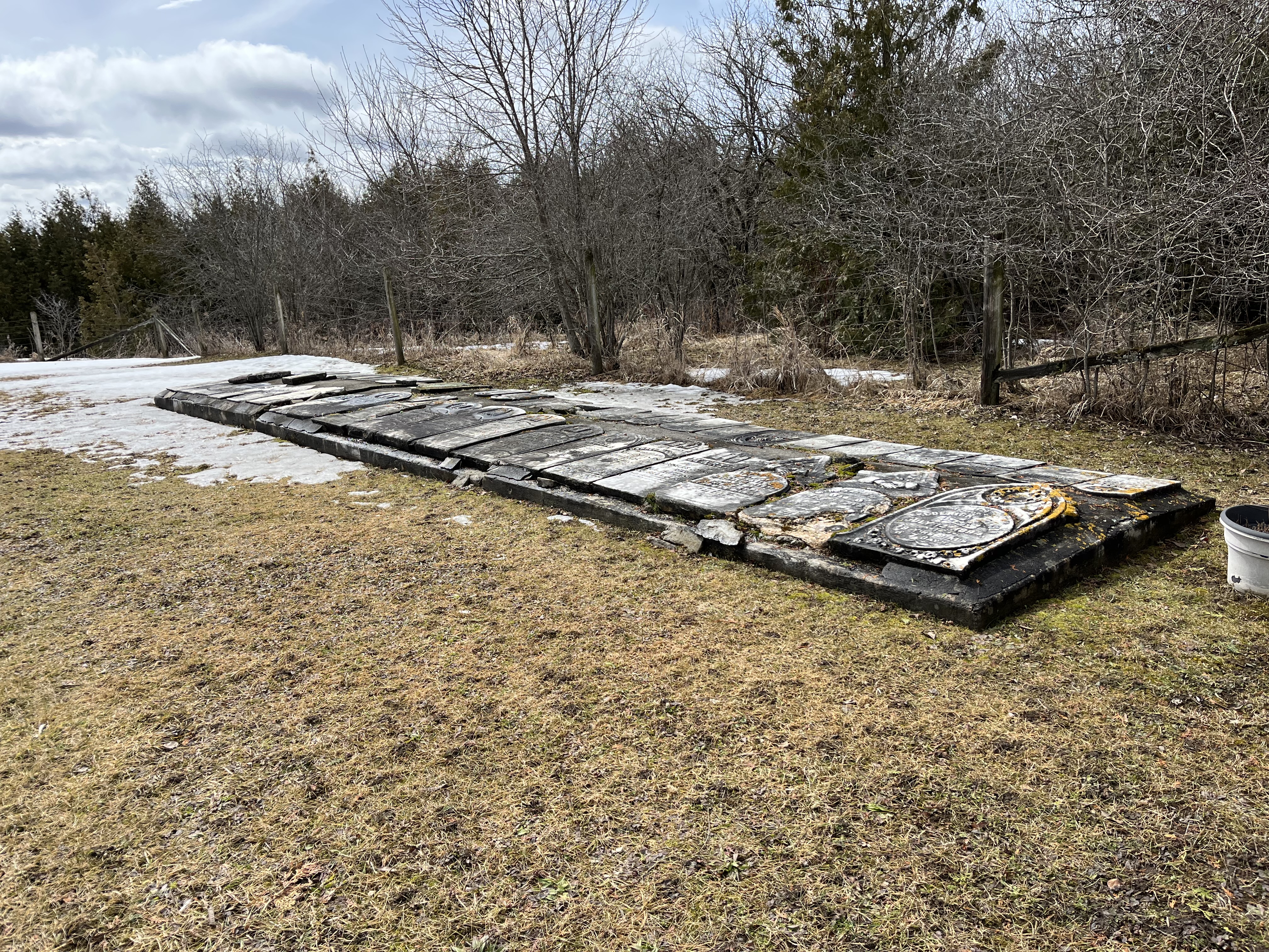
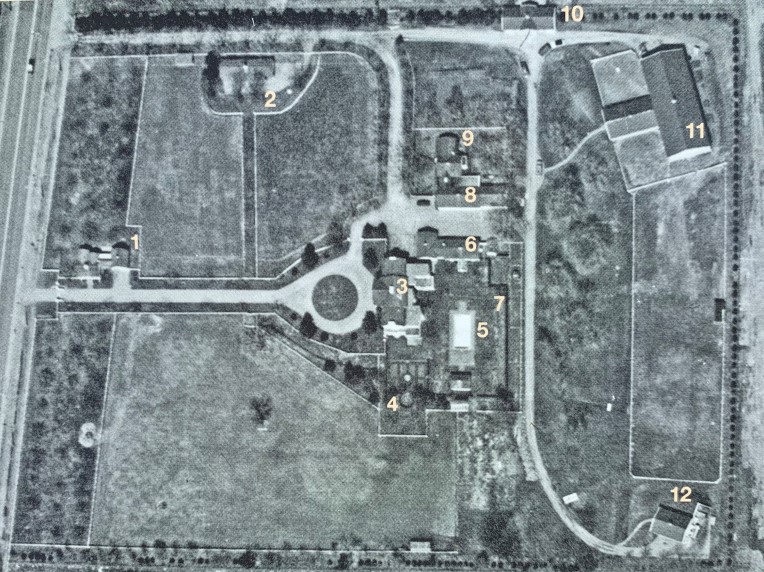
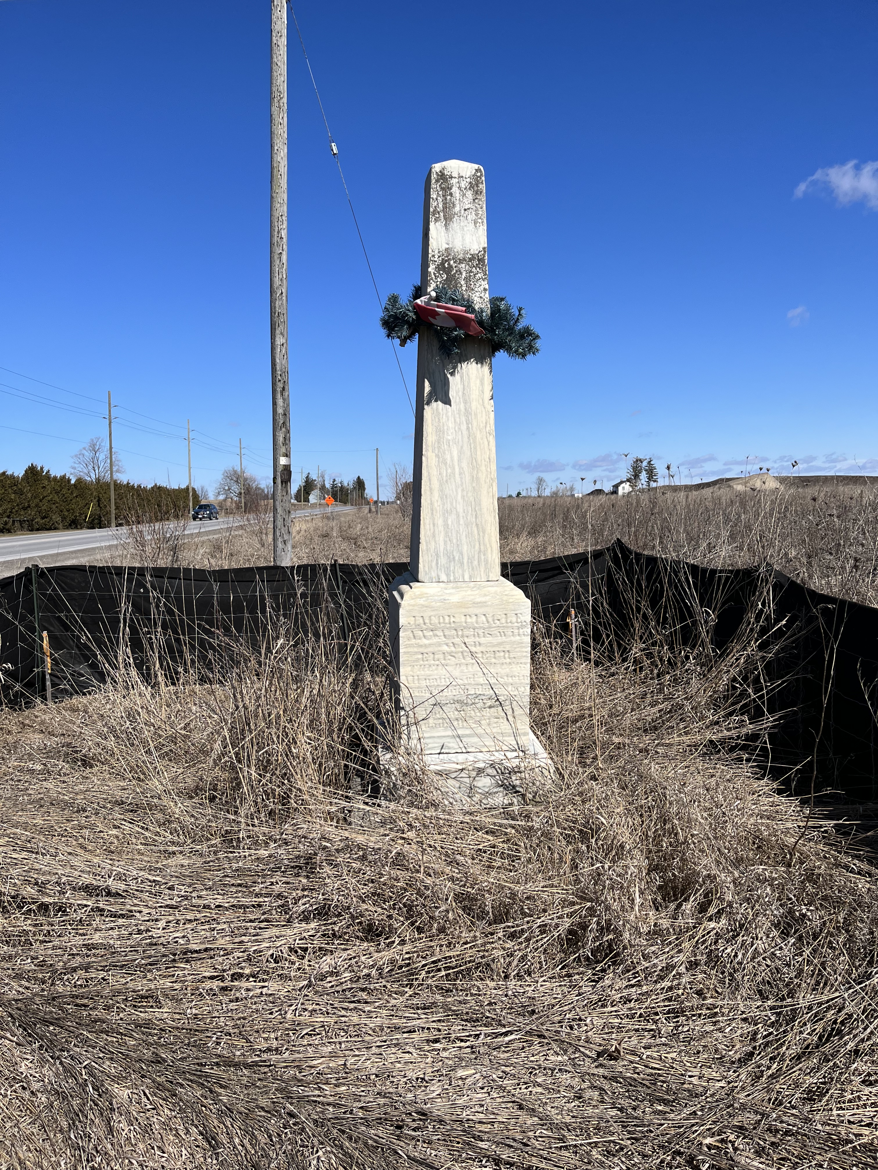
Located near the end of the driveway is a single stone marker which indicates the grave site of Joachim and Anna Marie Pingle and their daughter. They were original members of the Berczy Settlers who came to Markham in 1794. None of the Pingle family buildings remain on the lot but the cemetery is a reminder of the family. It’s likely that the current marker replaced three individual ones from earlier.

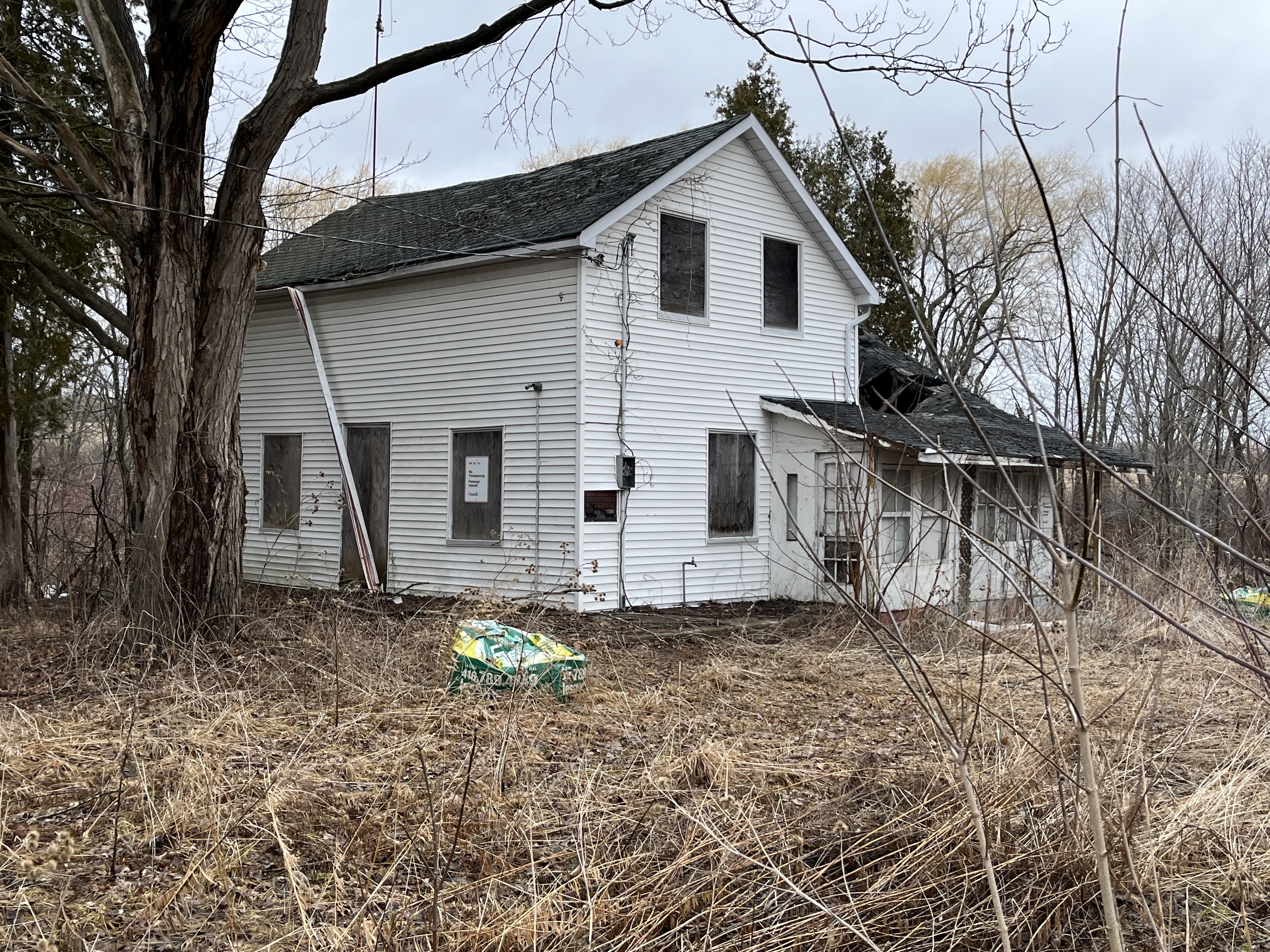
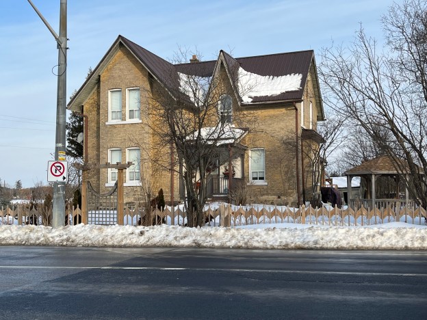
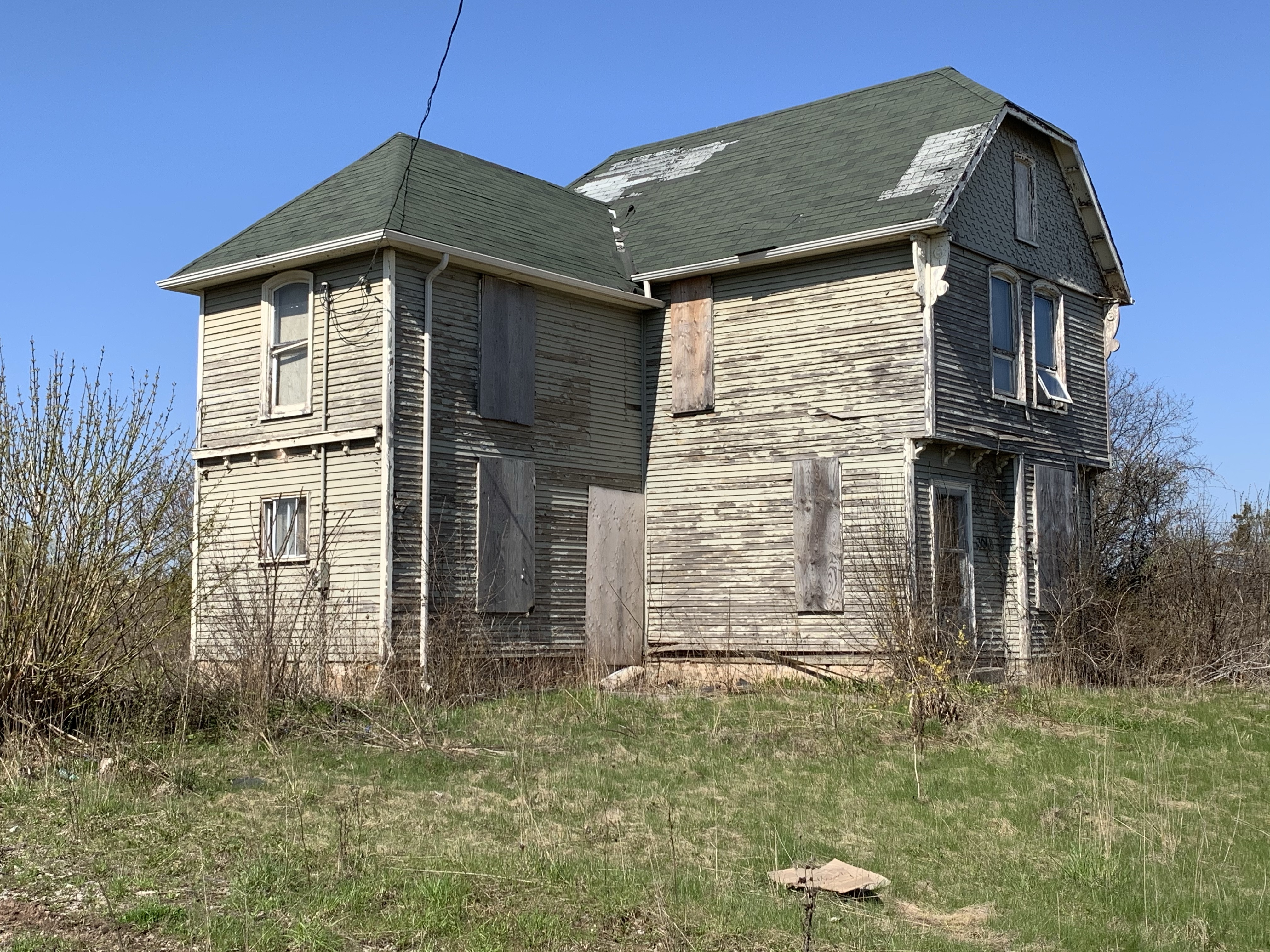
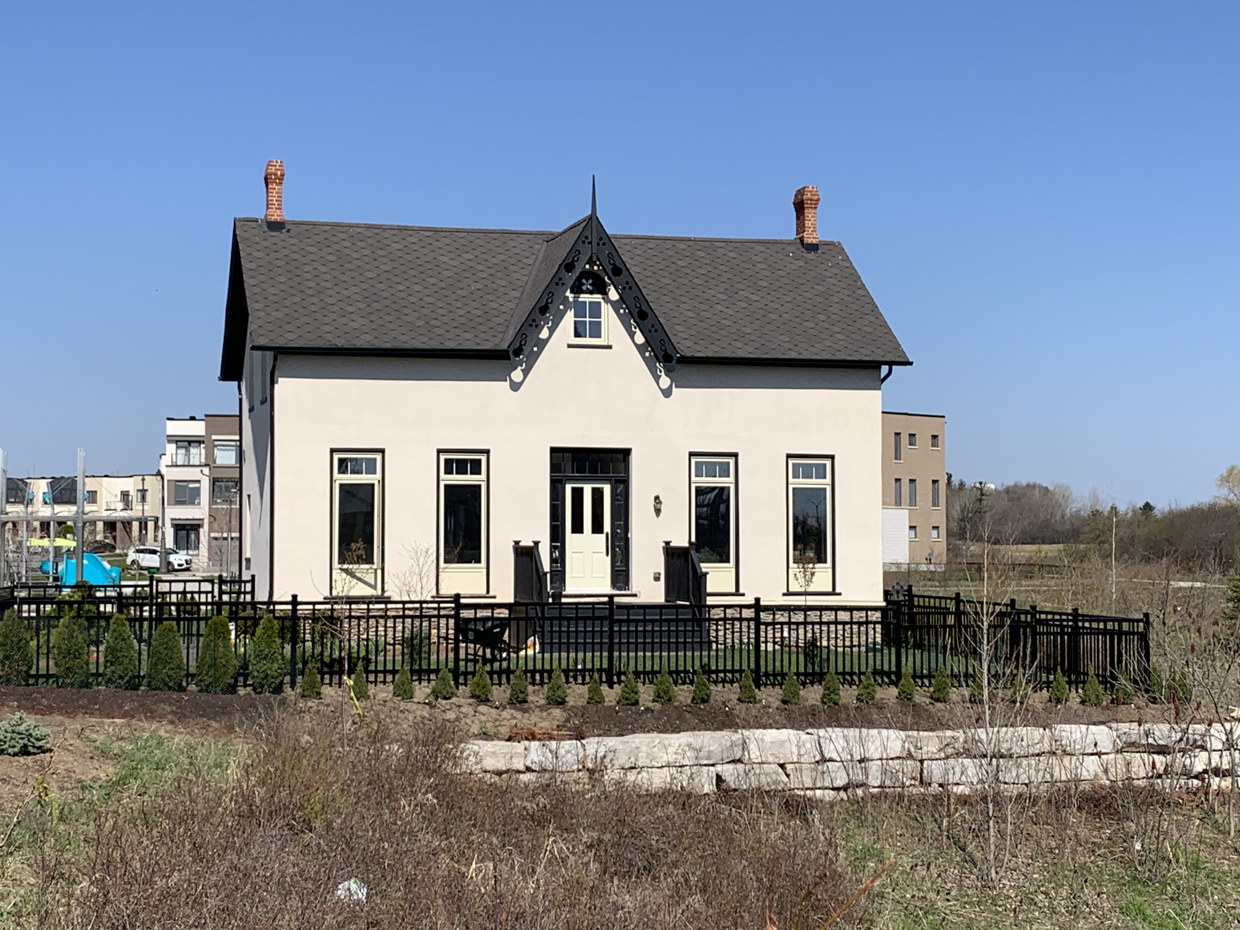
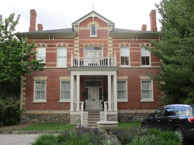
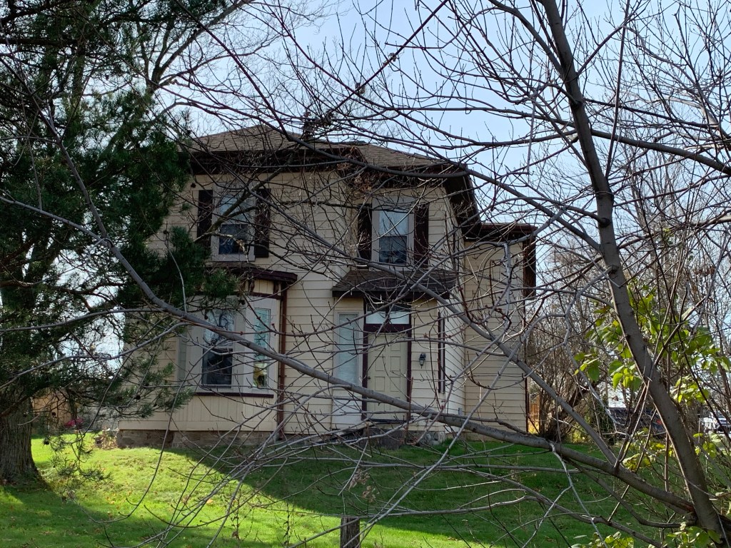
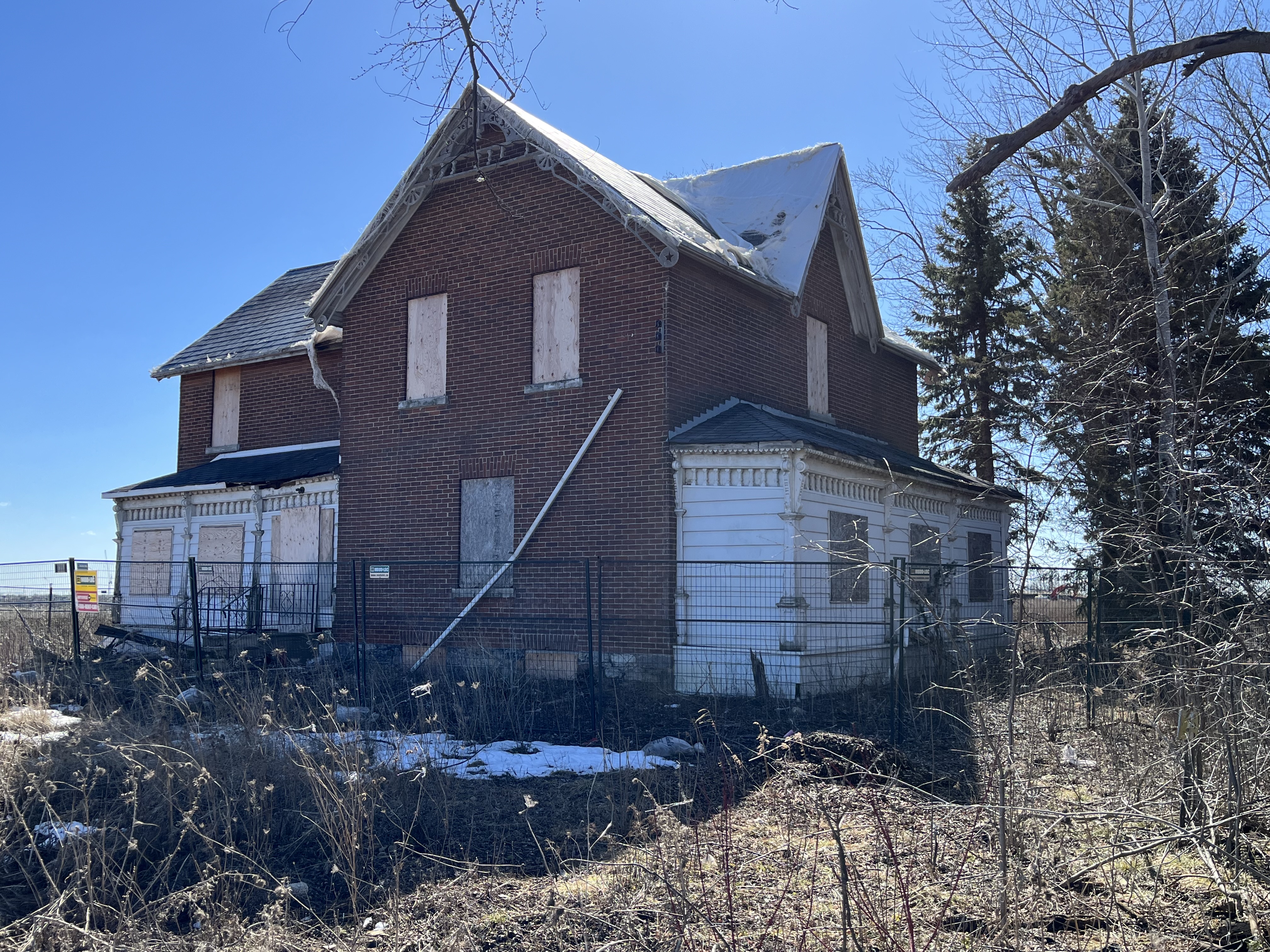
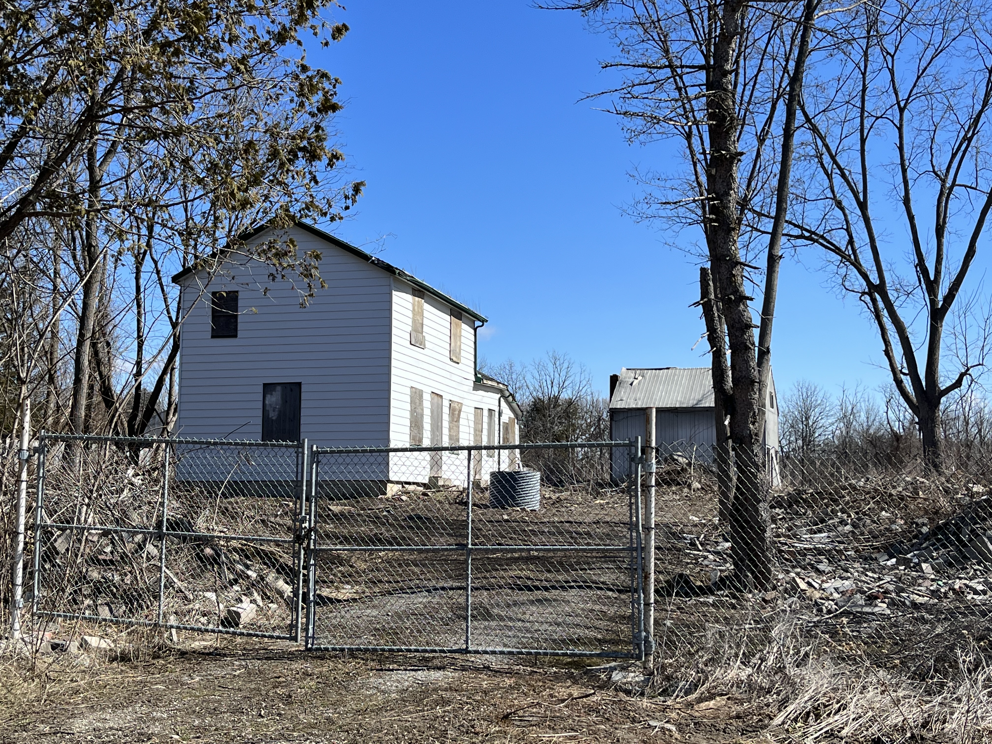
This regency style house was built in 1856 by George Henry Summerfeldt Sr., the son of John Henry Summerfeldt, one of the Berczy settlers. The house remained in the family for three generations and is now listed as part of Markham’s heritage inventory. Like the other houses shown in this post, it sits on farm land which is being developed for housing. The homes appear to be in the process of being salvaged and hopefully restored.

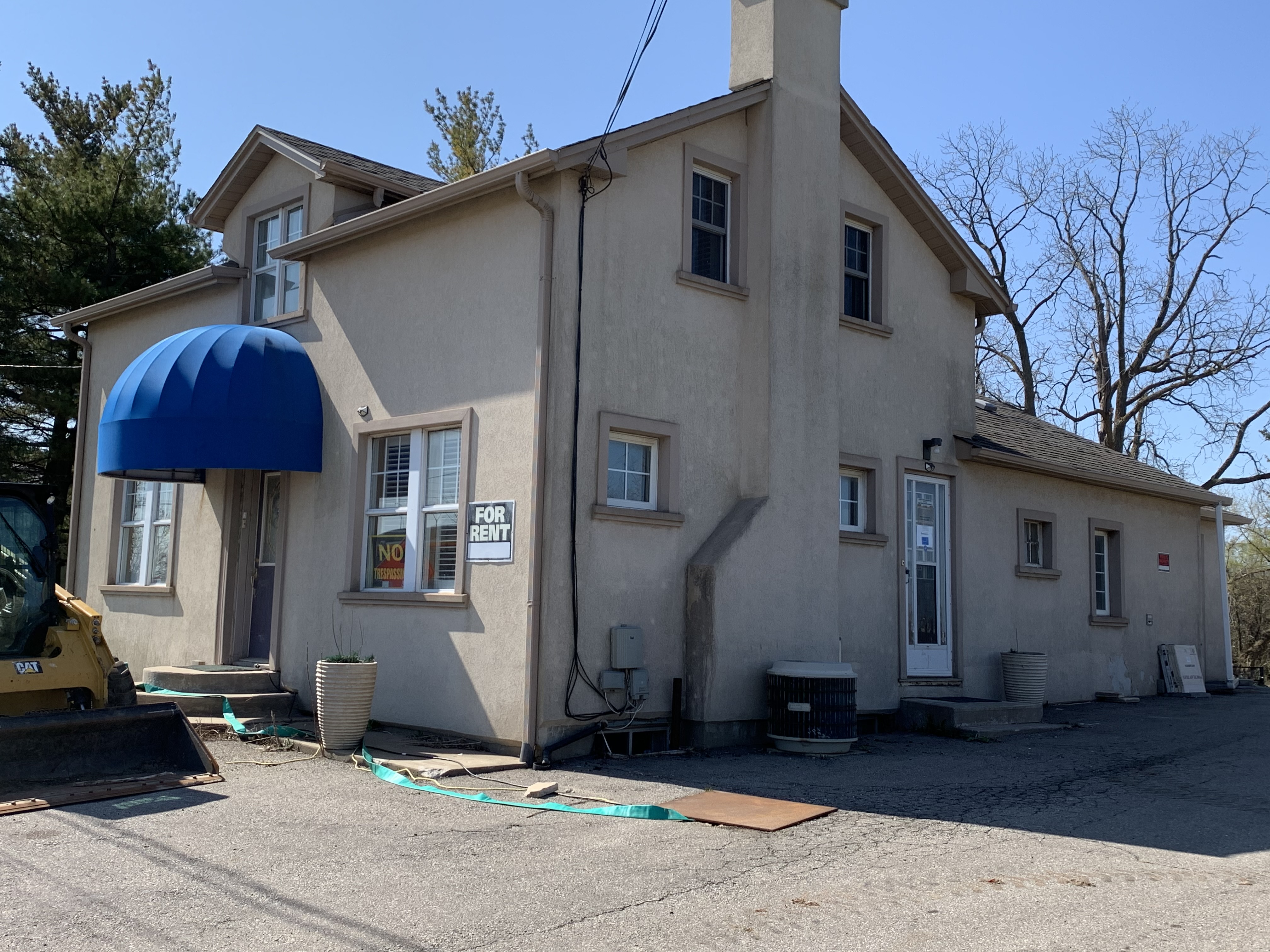
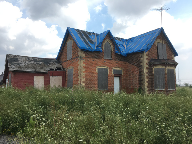
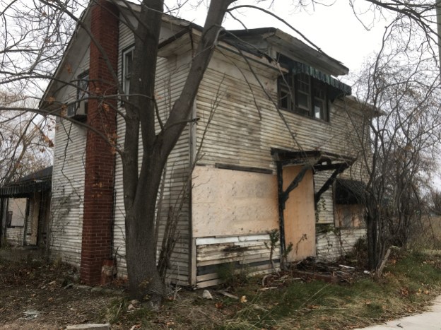
The Wegg farm was originally patented to Jacob Pingle but was sold to John Wegg in 1874. When Arthur Wegg, son of John, passed the farm on to his son in 1922 he had a four-square Edwardian home built for his retirement. The house was later owned by a restauranteur and then operated as a country market. Since 2013 it has been waiting for the development of the property into residential uses.

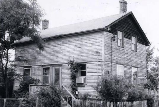
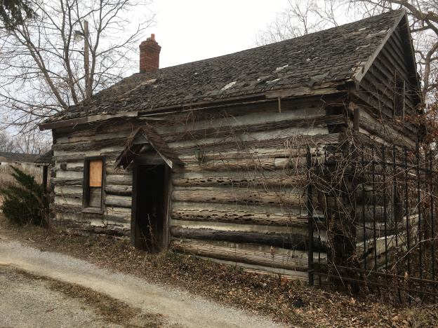
William Bergen lived in Cashel at the time of the 1861 census. He was employed as a general labourer but also had his own broom and basket making business. The simple house he built for his family was originally a single story in 1863 when it was built. Some time later in the 19th century it had a second story added to it.

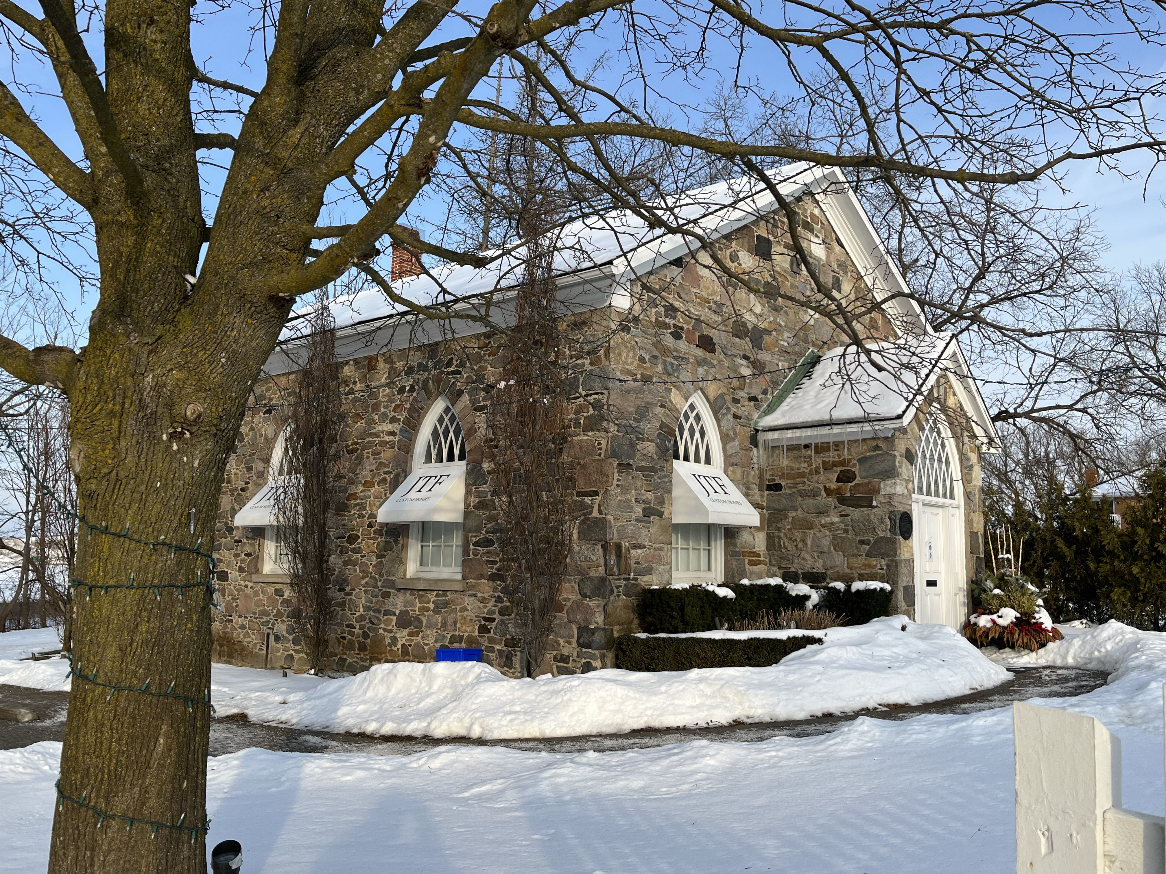
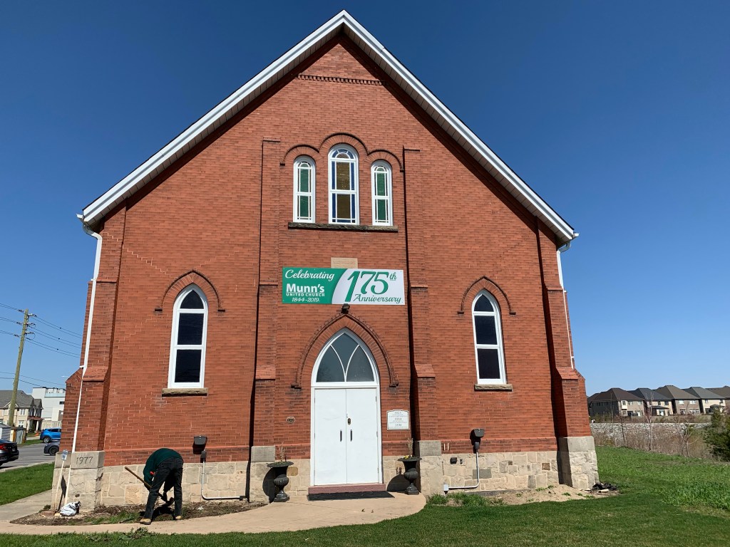
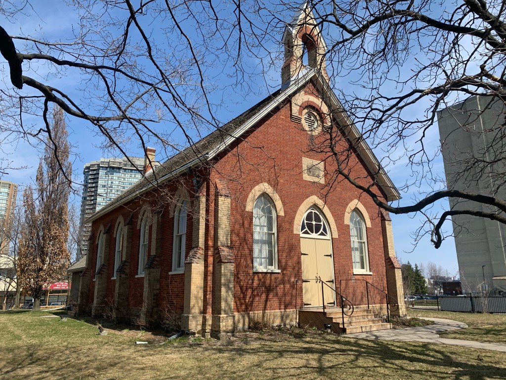
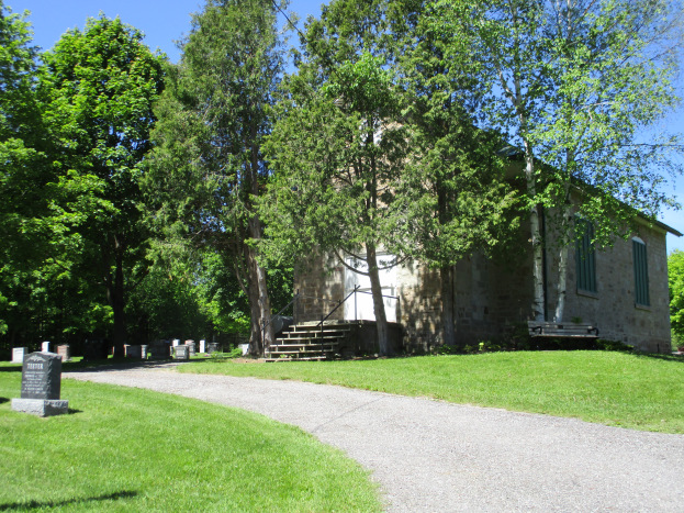
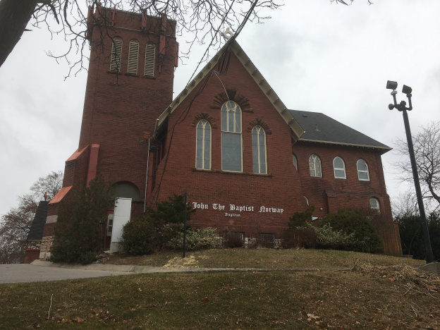
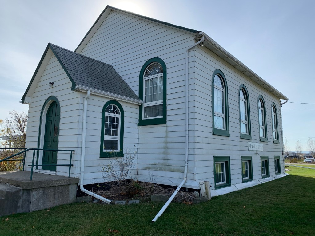
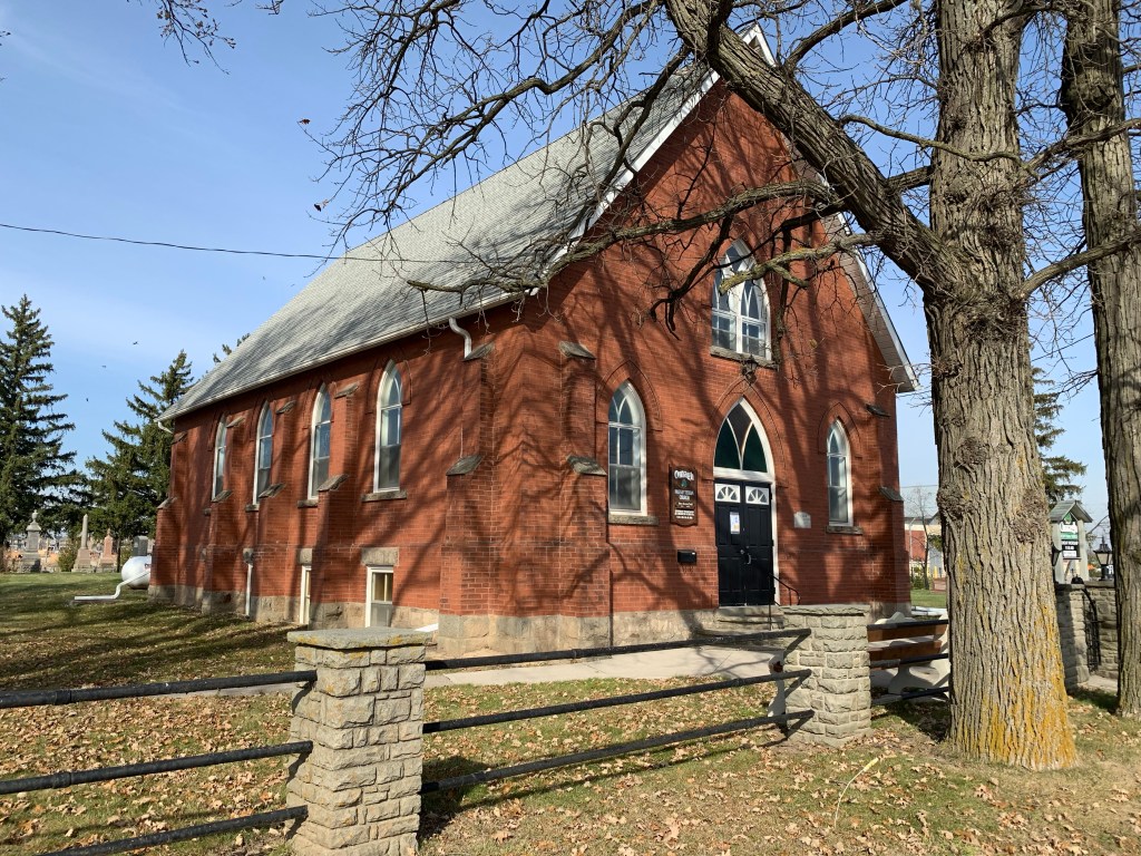
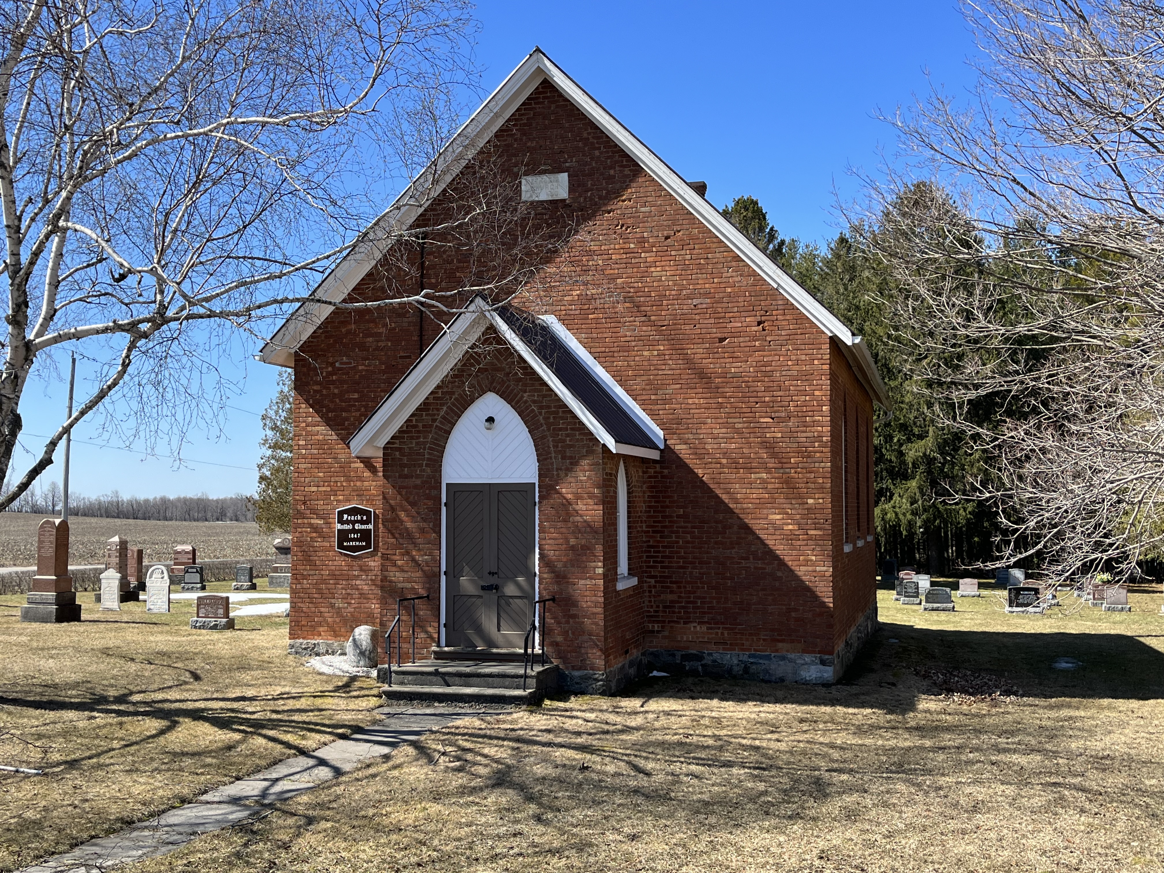
Peach’s United Church started as a Methodist Church and was constructed in 1890 on land donated by Thomas Peach. The brick building currently on the site replaced a wooden structure which was erected in 1847. The Methodists formed the United Church in 1925 along with some of the Presbyterian churches and some Congregationalists. Peach’s United Church stopped holding services about 50 years ago but the cemetery is still active. The Peach house was built in 1845 and is circled on the map just south of the church and it is still occupied. Unfortunately, there are a lot of trees in front of the house and I couldn’t get a decent picture of it.

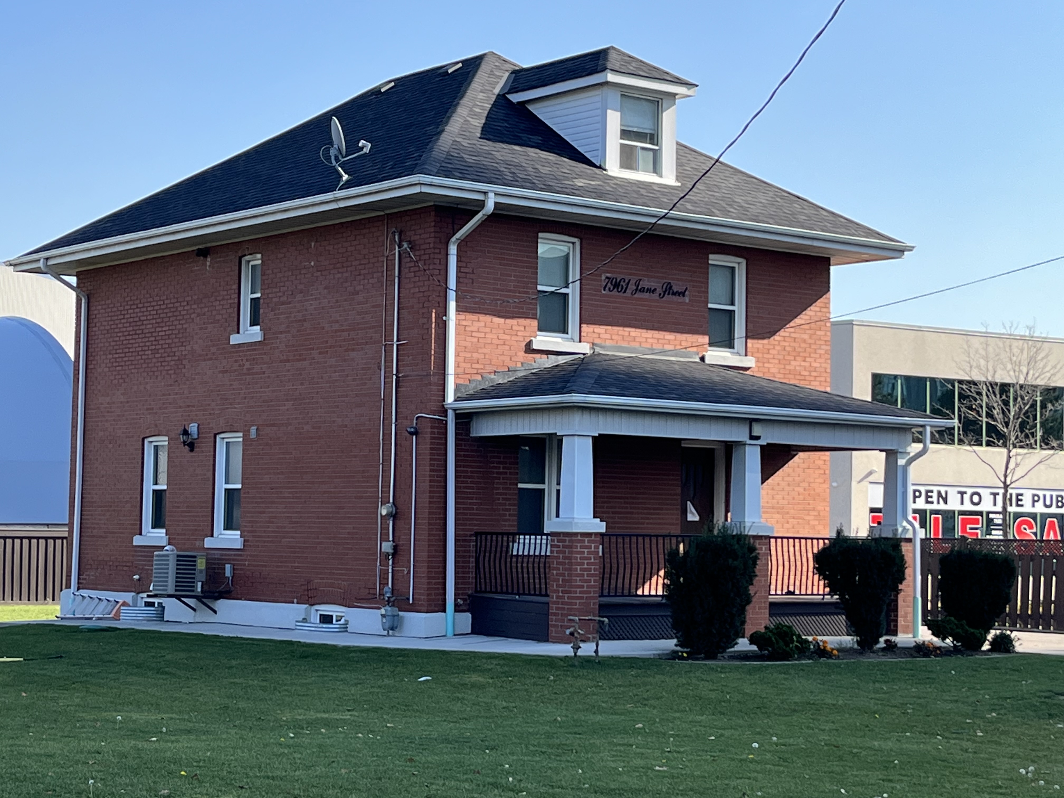
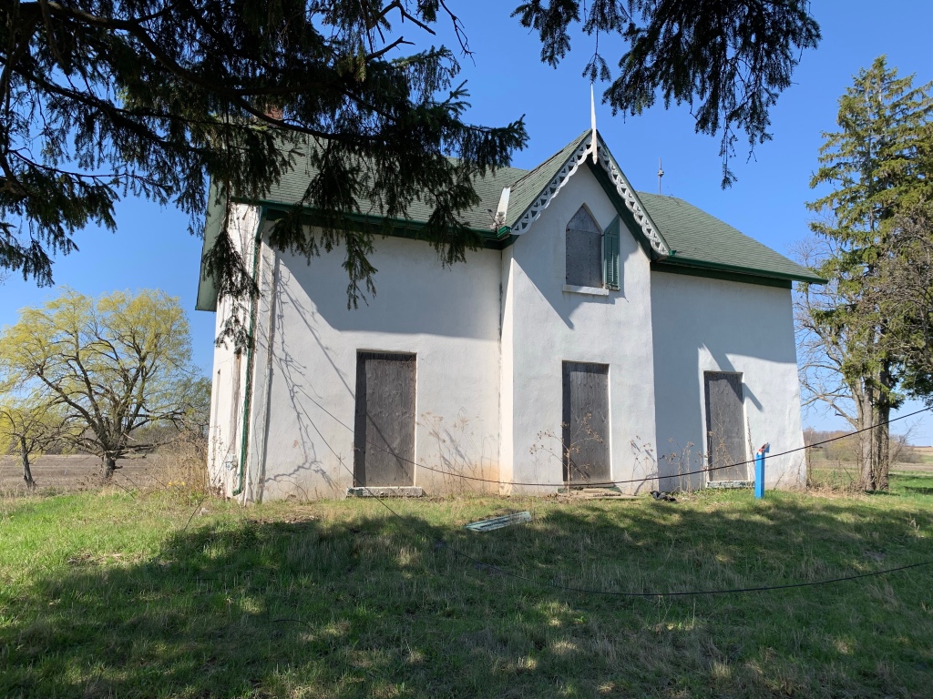
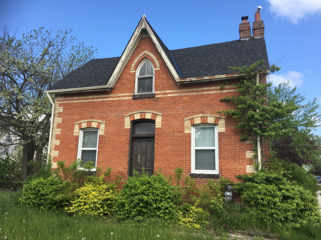
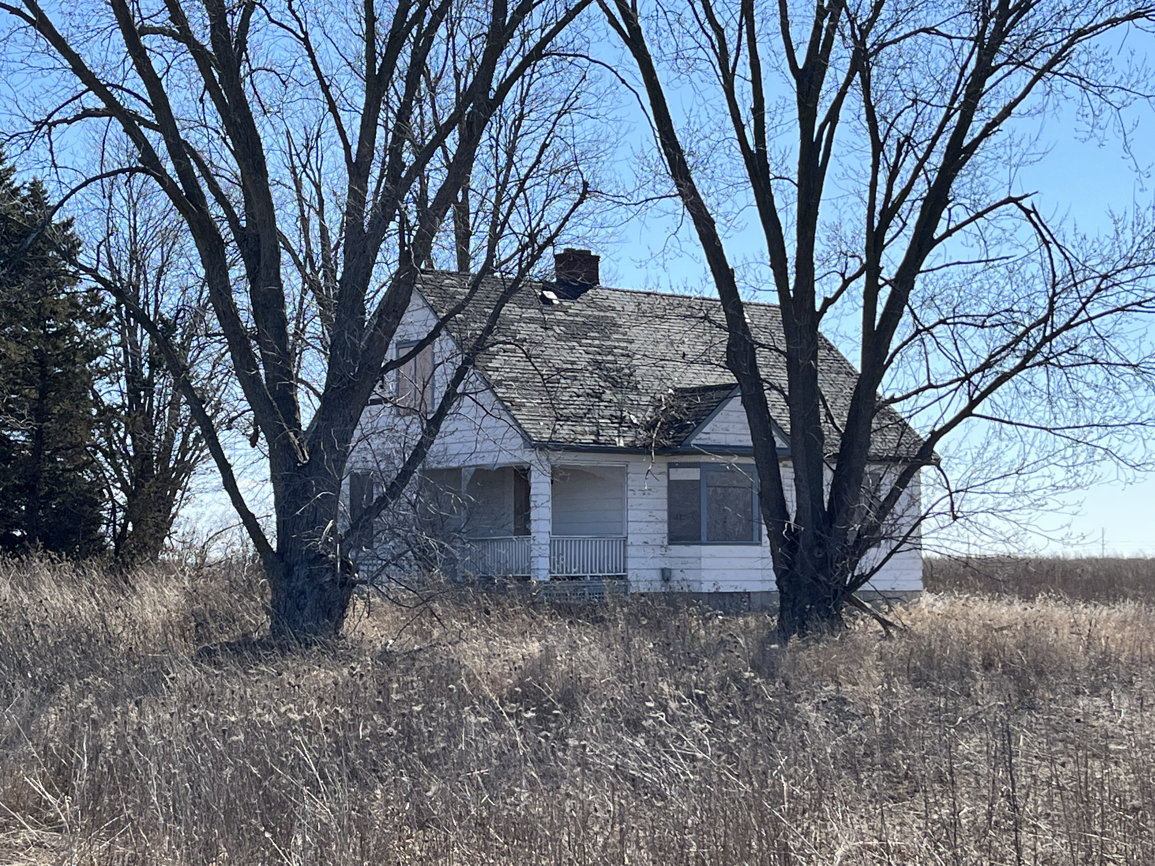
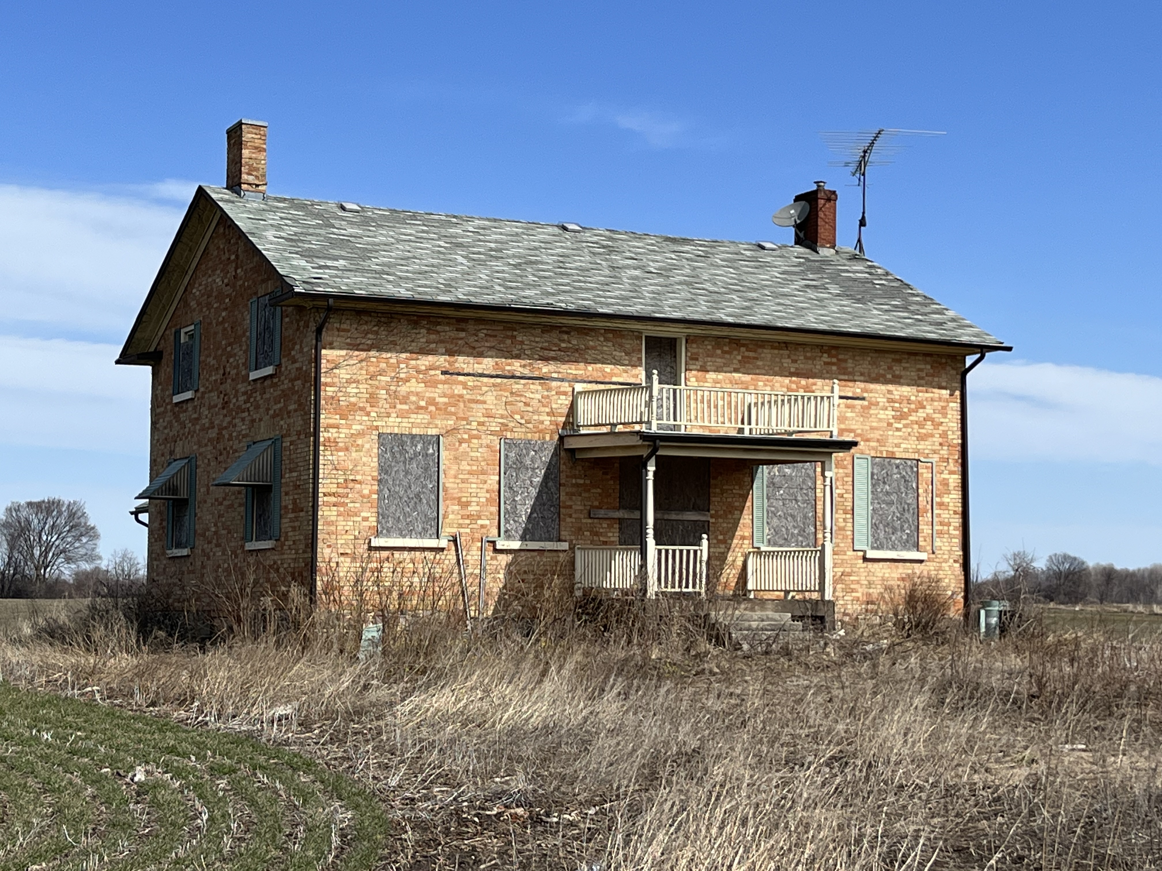
The George Haacke house was built in 1955 and was used by three generations of the family until it was sold to John Wilmot Warriner in 1902. The property was farmed until 2014 although it has been owned by a developer since 2011. The two story, five bay house was quite large compared to contemporary cottages of the same era. A nail board along the front wall indicates that the house used to have a much larger front veranda which was replaced with the smaller one at some point in time.

Markham seems to have done a very good job of designating, and then protecting, their historic buildings. One of the most unique things is the creation of Markham Heritage Estates where historic buildings can be relocated and lived in. At least one home from Cashel has been moved to this site near the Markham Museum.

Related stories: Markham Heritage Estates, Markham Museum

Google Maps Link: Cashel

Like us at http://www.facebook.com/hikingthegta

Follow us at http://www.hikinghtegta.com

Also, look for us on Instagram

Edgeley – Ghost Towns of the GTA

Sunday, November 20, 2022

The community of Edgely was centered around the modern intersection of Jane Street and Highway 7. The first Europeans to settle in the area arrived around 1800 from Somerset, Pennsylvania. The northeast corner of the intersection had a hotel while the southeast corner had the general store which also had the post office from 1872 to 1960. A steam driven shingle mill was located on the northwest corner. A cider mill was located just south of the general store which produced cider, apple jelly and apple butter until it closed around 1900. Along with a community hall, there was also a blacksmith, dressmaker, a shoe maker, a wagon shop, a casket maker and two slaughterhouses.

In 1823 an acre of land was deeded to the Mennonite congregation in the Edgeley area for use as a cemetery and Meeting House. Jacob Smith Sr. (originally Schmitt) granted the land which currently is the most tangible evidence of the former community. After the Meeting House was moved to Black Creek Pioneer Village in 1976 the cemetery wasn’t maintained and by 1985 many of the earliest stones were in disrepair. The city of Vaughan gathered them together into a cairn to protect them from further deterioration.

The Meeting House was built in 1824 and clad with horizontal board siding. It was used for 99 years before being closed in 1923. It was operational again for a brief period between 1963 and 1976 after which it was moved to Black Creek Pioneer Village. It is the oldest surviving log Meeting House in Ontario and was built out of first growth white pine that was cut in the area of Edgely. Services were only held in the church every fourth Sunday because the pastor was shared with other Meeting Houses in the area.

The benches and wood stove inside the meetinghouse are original to the building. As per Mennonite custom, none of the wood was painted. The work was done by hand and even the nails that were used were forged by the local blacksmith. The total cost of the building, not including the stove was $221.

The drive shed was built around 1860 and used to store carriages while the Mennonites were attending services at the meeting house.

An archive photo from about 1900 shows the Meeting House, also known as Schmitt Meeting House, along with the original drive shed. This shed was replaced in 1916.

Edgley had two buildings that were used by the local farmers to butcher their livestock. It is a timber frame structure that is clad with board and batten siding. When it was built in 1860 there was no easy way to store large quantities of meat and so the local farmers would work together. One animal would be butchered, and the meat shared. When it came time to prepare another animal it would be provided by a different farmer. Once refrigeration became available this practice was no longer needed and in 1970 the building was moved to Black Creek Pioneer Village and opened as a rabbit hutch.

Most homes and farms had at least one apple tree and some had a full orchard. The fruit was harvested in the fall and stored for the winter to provide food for the family. Edgely had at least one of these storage cellars and it has been preserved by moving it to Black Creek Pioneer Village. The cellar was dismantled and moved to the village over a 65-day period. Two sets of wooden doors were used to help insulate the interior so that the fruit would be better preserved.

Inside, the storage cellar is just eight feet long and seven feet wide. The fruit or root vegetables were placed in the wooden bins and covered with layers of straw for better insulation and to increase the storage life. The small vent at the back of the building could be opened or closed in order to regulate the temperature inside.

A single house remains from the community, and it is located just south of the cemetery on Jane Street. This style of architecture is known as Edwardian and was built sometime between 1901 and 1910. It is also sometimes referred to as “four-square” because of the four windows on the front of the house.

The former community of Edgely has been almost completely erased from the landscape and is being replaced by high-rise condos. Fortunately, the cemetery is still there to mark the hamlet and a few buildings are being preserved at Black Creek Pioneer Village.

Related Stories: Ghost Towns of York Region, Black Creek Pioneer Village, Elizabeth Stong, Pioneer Cemetery Cairns

Google Maps Link: Edgeley

Like us at http://www.facebook.com/hikingthegta

Follow us at http://www.hikimgthegta.com

Also, look for us on Instagram

Mongolia – Ghost Towns of the GTA

Sunday, April 3, 2022

Mongolia was a community that grew around the modern intersection of Elgin Mills Road and Reesor Road. Peter De Guere arrived in 1801 and took the north west corner on lot 26. The adjoining lots were soon taken up as people cleared land for farming. As the community grew it got a tavern in 1841 and took on the name California Corners. It was never more than a farming community with a school, Methodist Church, and a Temperance Hall beside the blacksmiths shop. The rural atmosphere was lost in 1972 when the federal government decided that the flat land north of Pickering would make a good site for a future airport. They expropriated the entire town and then never built the airport. Studies show it won’t ever be needed and slowly the government is giving sections of the airport lands to help create Rouge National Urban Park. This is a far better use for the land, although it could still be productive farm land again. To explore and record what remains before it is lost we parked at the trail parking lot on the south east corner of the intersection. From there you can walk up or down Reesor Road to view the old homes or follow the trail to the historic Boyles Pioneer Cemetery. We did both. The 1877 county atlas section below shows many of the homes that still remain as well as the trail to the cemetery, which is marked with a star.

It was in 1853 that James Holden bought the corner of David Nightswanders property and the following year he opened a general store which he operated until 1861. When Nightswander got a post office for the town in 1864 he was told the name California Corners could not be used and so Mongolia was chosen from a list of approved names. A house was added beside the store in about 1870 but the store and post office burned down in 1920, leaving just the house behind. It is now being used as an information centre for Rouge National Urban Park and is one of the few homes from Mongolia that is still in great condition.

Martin Noble built this farm house in1840 and like several other older homes in the community it has been covered in white siding. I wonder if it was built of field stone like so many of the local homes were in the mid 1800s. I think we’ll be able to find out soon as the roof is caving in on this home in spite of it being on the heritage listing for Markham. Mongolia appears to be falling victim to neglect like so many of the heritage properties in the Pickering Airport Lands. It’s interesting that a designated home can’t have unapproved alterations because they can detract from the heritage properties that set it aside for preservation. However, there’s no provision in the listing to require a property to be maintained even though lack of maintenance is seriously detracting from the heritage value of these buildings.

The fields and forests around Mongolia are littered with the neglected dreams of the former inhabitants. Many out buildings, barns and drive sheds remain as well as several abandoned cars and at least a couple of boats. Now that this section of the former airport lands has been designated as part of Rouge National Urban Park it may be that some of this will be demolished while the rest is left to vanish into the new forest as it regrows across the farm fields.

The James Collins house was built in 1850 and was also subjected to white siding which likely hides a lovely brick or stone home on its stone foundation. The entire back side of this house is missing the roof and it won’t be long before this heritage designated home is lost forever.

The drive shed on the property is still in very good condition even though it may have been 50 years since the farm was active.

Another heritage property is the David Burke house from 1850. This home still looks pretty solid but has had all the interior walls stripped down to just the framing. One noticeable alteration to the home is the ground floor windows which have been replaced with smaller ones. Buff coloured bricks have been used to fill in the openings around the smaller windows which hides the alteration from a casual glance.

The Adam Betz house stands on the south west corner lot as it has done since 1851. Another one of the white siding victims in town, it stands an a thick stone foundation that may indicate another beautiful stone house.

Henry Barkey took over the North East corner of the intersection from Jacob Barkey in 1832 and lived near the centre of the lot. In 1860 a blacksmith shop was built near the corner of the intersection and was rented by George Calvert who appears in the 1861 census and the following couple as well.

The tenant in the house next door was usually the blacksmith although after the blacksmith shop closed it was rented to various people until it was taken over for the airport. It still appears to be lived in under a rental arrangement with the government.

School section #22 originally occupied a frame building on the east side of Reesor Road but in 1882 a new brick school house was opened across the street. When the school was closed the building was renovated and continues to serve as a residence.

There is a new trail that leads west from the parking lot and then turns south. It currently runs for only a little more than a kilometre but will eventually connect to a new parking lot on Major Mackenzie Drive. If you keep your eyes open you will find a 1965 Plymouth Fury which has obviously been parked here for quite some time. The Fury model was first released for the 1956 model year and was updated to its fourth generation for 1965.

The Methodist church stood north of the main intersection but its burial grounds were on the property of John Boyles. Located on a small plateau overlooking the river, it stands about 400 meters from the road. The stones have been gathered up and placed into an unusual ground level cairn with the stones lying flat. They may be more subject to the weather than they would be in a more common vertical presentation. There are at least 47 burials commemorated in this cairn and one additional one from 2002 that has a grave marker beside it. Please note that the trail ends before the cemetery and it is not part of the trail. If you choose to visit, please do so respectfully.

The gravestones in this cairn mark the lives of many of the early families in the area. John Boyles was the property owner and he died June 23, 1885 at the age of 91 and is buried here. Catherine Kester died on Sept. 12, 1816 in her 60th year and her headstone is one of the earliest that I’ve photographed anywhere in the GTA.

We previously looked at Brougham, which is another one of the Pickering Airport Lands ghost towns, which has also been left to rot and be demolished. Mongolia has a lot of heritage designated buildings that won’t be around in another ten years because they’re already becoming structurally unsound.

Related stories: For more information about the Pickering Airport check out our post Brougham – Ghost Towns of the GTA.

Google Maps Link: Mongolia

Like us at http://www.facebook.com/hikingthegta

Follow us at http://www.hikingthegta

Also, look for us on Instagram

Eversley – Ghost Towns of the GTA

Sunday, March 6, 2022

Eversley, also known as Tinline Corners, developed in the early 1800s at the intersection of 3rd concession (Dufferin Street) and 15 sideroad and was likely named after Eversley, Hampton, England. It never grew to more than a hamlet and in 1869 the population was listed as 29. This included two blacksmiths, two carriage makers, a doctor, a pastor, a butcher, three farmers and James Tinline who was a general merchant and post master. There used to be a few more buildings than the ones that remain but both of the homes in the 1908 archive picture below still stand.

The oldest surviving building in Eversley is the Presbyterian church which was built in 1848. The congregation and the cemetery date to 1834 under a circuit preacher but three years later the local school teacher, John Tawse, took on the role of pastor. In 1860 Dr. James Carmichael became the second pastor and he remained until 1910. When it closed in 1958 the minister from Timothy Eaton Memorial Church in Toronto spoke the final sermon. Lady Flora Eaton bought the church in 1960 and handed it over to the York Pioneer and Historical Society because she felt it was important to preserve small town history. She was raised in Omeemee and knew the value of community in a small village. A cemetery is located on the north side of the church but was inaccessible due to the snow. It would be interesting to have a look there for the grave marker of Henry Frost (1816-1851) which has an unusual music motif.

Starting in 1837 the church and school shared a log building a little to the south of the present church. In 1843 a new school was built of red brick just to the north of the log school. After the church moved to their new building the log one was taken apart and used in other buildings. In 1893 a third school building was erected, this time across the road, using buff brick with red accents. In 1961 two more classrooms were added on the front and it operated for another decade. One important teacher from this school’s history is Henry Frost who is responsible for developing the music program for Ontario schools. He taught here from 1850-1851 and then he passed away and was laid to rest in the cemetery across the road.

James Tinline built a store on the north east corner and served as post master when the post office opened there in 1865. Henry Rogers built this house next door in 1887 which he operated as a mercantile. When Tinline’s store burned down, this building was owned by a Mr. Gellatly who took over the post office until it closed in 1928. A side entrance was provided to the family home while the main one served the retail business. This home has had siding, window moldings and gingerbread added since the time of the historic photo above.

Robert Riddett operated a wheelwright shop where he made wagons and carriages on the north west corner of the intersection. It has since been demolished and the land is now under cultivation by a farmer who leases it from Seneca College. Meanwhile in 1900, after the loss of Tinline’s store, James Wells built a new home on the site of the former post office. Flora Eaton later bought the house and it served as the foreman’s dwelling for Eaton Hall Farm across the road.

On the south east corner a cheese factory was opened in 1878 by Job and James Wells. They made butter in the Winter and Spring and then cheese in the Summer and Fall. The cheese factory was closed and then demolished in 1914 but one of the small worker cottages remains as well as several out buildings that are all in poor condition. Alex Hurst also had a blacksmith shop on this corner.

One of the most prominent buildings in the old community of Eversley is the Henry Pellatt barn because it is quite close to15 sideroad. It was built in the early 1920s and later sold to the Eaton family along with 400 acres of land which they added to their estate, Eaton Hall. The foundation is surrounded on four sides with 3 over 3 windows giving it a unique look and allowing lots of light into the animal pens. Henry Pellatt owned Casa Loma and the nearby Marylake estate in the 4th concession.

Starting in the 1920s Eversley was transformed by the arrival of the Eaton family who bought 700 acres in the north west area of the community. We’ve featured many of their buildings in our Eaton Hall post but we left the gate house out due to space limitations. This building is visible from Dufferin Street and is now part of the main entrance to Seneca King Campus.

The Schomberg & Aurora Railway was incorporated in 1896 to connect with the Toronto & York Radial Railway at Yonge Street. Construction began near Bond Lake in 1899 and it opened in 1902. Eversley was served with three stops in close proximity. The first was Eversley Sideroad which was about a kilometer east of town on 15 sideroad. Eversley Station was basically across the road from the entrance to the Eaton Hall gate house. A third stop was located on 16th sideroad and was known as Cider Mill Crossing. June 10, 1927 marked the last run on this line and today the old right of way can be identified from Google Earth and is used for a hiking trail through Seneca King Campus.

The Eaton Horse and Cattle Barn was completed in 1923 and was a notable sight in Eversley until it was destroyed by a fire in 1937. Lady Eaton promptly had it rebuilt but the two silos and clock tower were destroyed in a second fire on April 18, 1966 and were never replaced. The archive photo below shows the barns in their prime.

This ornate latch is found on the old dairy building from the Eaton Hall farm and is a reminder that Eversley has a history that includes the craftsmanship of the local blacksmith.

A sizeable portion of the former community of Eversley is now under the management of Seneca King Campus and there’s plenty of trails to explore. You can park in one of the lots on campus and explore the trails which include the Oak Ridges Moraine Trail. This robin was splashing around in a puddle and complaining about the recent weather.

Eversley has lost most of its residents but many historic buildings remain and none of the small town charm has disappeared.

Related stories: Pioneers of the GTA – Timothy Eaton, Eaton Hall, Toronto & York Radial Railway, Bond Lake, Casa Loma, Marylake

Google Maps Link: Eversley

Like us at http://www.facebook.com/hikingthegta

Follow us at http://www.hikingthegta.com

Also, look for us on Instagram

Trafalgar – Ghost Towns of the GTA

Sunday, May 16, 2021

Most people are familiar with Trafalgar Road but it could just as easily been named Postsville Road. That’s because the early name for the community of Trafalgar was Postsville. The Post Family settled at the intersection of Trafalgar Road and Dundas Street sometime shortly after 1807. Ephriam Post owned two lots #12 NDS (North Dundas Street) on the north east corner and lot 13 SDS on the south west corner. He built an inn on lot 13 and Posts Inn was a busy place serving as a change house for horse drawn stagecoaches that used to operate along Dundas Street. Hiram Post took over the Inn in 1841. The community was known as Posts Corners from 1815 until 1851 when it became Postsville. By the time of the 1877 County Atlas below it had been renamed Trafalgar. The points of interest in the story below have been circled on the map.

The community grew slowly and by 1869 had about 80 residents. There were two hotels, a butcher shop, a grist mill and carriagemaker as well as a blacksmith. It was in 1834 while James Thompson owned the north west corner of Governor’s Road (Dundas Street) and 7th line (Trafalgar Road) that small lots began to be sold for homes along both street frontages. These few homes formed the nucleus of the hamlet of Post’s Corners. The house just north of the corner was built around 1850.

The house next door is one of my personal favourites because although it is simple, and lacks extensive ornamentation, it has a quite unique look to it. The clipped gable on the front might be the only one of its type in the hundreds of historic homes featured in blogs so far. The style is Queen Anne and it was built around 1890 for Dr. Johnstone and his family while he worked as the veterinary inspector for Halton County. He was also the deputy reeve of Trafalgar Township. He died September 3, 1959 and was buried in Munn’s Cemetery where his wife is also interred. The family had been supporting members of Munns Methodist Church. This property is designated for condos but the current plan calls for the preservation of this house. I hope it is restored and put to good use.

James Appelbe came to Canada in 1815 from Ireland and by 1831 had married and settled in Postsville. For a few years he taught school at Munns Corners before becoming a merchant and postmaster. Locally, Appelbe was known as The Squire and was a justice of the peace. He also served as one of the first directors of The Bank of Toronto. Appelbe eventually acquired most of the land around Trafalgar and was one of its best known residents. His 1850 home used to stand closer to the intersection but it has been restored and moved by Great Gulf Homes after it was nearly destroyed by vandals. The house has four full length windows that reach from the floor to the ceiling on the main floor giving it a unique look and plenty of light.

Lot 12 on the North East corner was patented to Hugh Howard in 1807 and by 1820 he was able to build the wood frame house that stood on the property until just recently. John Clements bought the property in 1831 and when he passed away in 1873 it went to his son Matthew. The 1877 county atlas shows the property as M. Clements with two houses on it. This earlier house was lived in recently enough that the picture below shows a window air conditioner. By 2013 when the Cultural Heritage Assessment of Trafalgar Road was conducted the roof had caved in as had some of the walls. It has since been completely demolished.

The second farmhouse on the Clements property was built in the 1870s, likely by Matthew. This stucco farmhouse has been vacant long enough that the front yard is overgrown with hawthorn and other first generation regrowth trees that mask it from the road.

John Clements also owned the property across the road in the 1850’s but by 1877 had sold it to James Morrison who lived here until 1907. The house has belonged to the Bentley family since then but now sits empty waiting to find out what fate the developers have planned for it.

An old blacksmith shop still stands at the corner of Trafalgar Road and Burnhamthorpe Road but it is well on its way to becoming just another foundation in a field. Which means that when the developers arrive in a few years it’ll be gone completely.

John Jones owned the property with the blacksmith shop in the 1880’s and the family house still stands next door. It looks to have been recently abandoned and could be restored easily enough and I wonder what’s behind the siding? Does that gable window have the typical pointed arch of a gothic revival home?

Daniel Munn arrived in 1803 and took possession of the lot at the corner of sixth line and Dundas Street and began clearing his farm. That same year he set aside a small corner of the lot for a church but Methodist preachers would continue to hold meetings in the family home until 1844 when the first frame building was erected. A cemetery was opened across the road and in 1898 the present brick building was consecrated. In 1925 the congregation voted to join the United Church of Canada. When Dundas Street was widened in the 1970’s the church was moved 40 feet back from the road.

Munns Corners cemetery has a lot of older markers as it was also the primary cemetery for Trafalgar. Munn’s Church can be seen across the road.

Daniel Munns grave marker has faded to the point of being unidentifiable but you can still note the names of many of the pioneers on the county atlas above.

The south west corner of Trafalgar is being developed with high rise condos and the remaining farmlands are all owned by developers. It doesn’t seem likely that very much of the original community will remain in ten years time.

Also see our feature Ghost Towns of Halton Region

Google Maps Link: Trafalgar

Like us at http://www.facebook.com/hikingthegta

Follow us at http://www.hikingthegta.com

Also look for us on Instgram

L’Amoreaux – Ghost Towns of the GTA

Sunday, April 11, 2021

The farming community of L’Amoreaux developed along Finch Avenue after it was founded in 1816 by a French Huguenot family of that name. It never gained much in population but it served a large number of farms in the area. There are still a few original houses as well as an early church and the well known Zion Schoolhouse.

With the ongoing lockdown restricting travel I chose this location to investigate because it could be reached on my lunch from work. I’ve included two County Atlas images which each show the points of interest on their respective sides of Highway 404. The map below shows the Scarborough side of town with two houses marked as well as the cemeteries for the Wesleyan Methodists and the English Church (Anglican).

Christie’s Wesleyan Methodist church stood where the parking lot for Bridlewood Mall is today. This historic picture from around 1896 was found on the Scarborough Historical Society web site. The congregation formed in 1846 and lasted until it was absorbed into the United Church of Canada in 1925. The building was moved to Buttonville in 1938 leaving the cemetery beside it stranded in a field.

A cemetery was opened on Isaac Christie’s lot beside the church with the first burial coming after Permelia Roy passed away on January 10, 1849. The cemetery was closed in the 1930’s and in 1975 was incorporated into a little memorial garden in the mall parking lot. Unfortunately, I noticed that there has been some recent vandalism and at least one stone has been knocked over. There’s around 100 people interred in what is perhaps one of the least sedate of cemeteries in the city.

Isaac Christie along with Isabella Graeme bought lot 33 in Concession 4 in 1836 after emigrating from Ireland. Both are buried in the little cemetery on their farm and their grave markers have been incorporated into a wall for preservation. Several later marble stones still stand throughout the little garden.

Anglican church services were held in the L’Amoreaux log school from 1832 until 1840. A small frame church was dedicated in 1841 and served the community until 1935 when it was destroyed by a fire. The congregation temporarily moved into the Christie Methodist Church and in 1937 began work on a new building. When the city expanded to swallow the little community, they found their building was too small. A new church including senior apartments, seen in the background of the picture below, was dedicated in 1978. After that, the 1937 church was demolished.

Glendinning House was built in 1870 and originally faced onto Pharmacy Avenue when it was a working farm house. It mixes several different architectural styles into what is commonly referred to as Upper Canadian Vernacular. It blends Gothic, Georgian and Victorian traditions which likely marks the various additions that the family made to the home as more room was needed. The house was designated as having historical and architectural value and a notice was served to the developers that they had to incorporate it into the subdivision that was planned for the farm.

The Risebrough house was built around 1860 in the common one and a half story design with a gable and window over the front door. The original cladding has been covered over with aluminum siding but it is believed that the rear kitchen may be the original home. It is currently being used by an Islamic congregation who might lose the right to use the building for religions ceremonies due to problems with parking.

Half of L’Amoreaux was in Scarborough Township and the other part in North York. The three places of interest from the west end of town are circled in green on the County Atlas below. These are the Primitive Methodist Church, Zion School and the property of Sam Kennedy.

The Primitive Methodists built their church on the west end of town and replaced it in 1873 with this buttressed brick building with simple gothic revival accents around the windows. The church is still known as the Zion Methodist Church although it ceased that function many years ago. The building was empty in 1971 when the city acquired it to be used as a community event space.

School section #1 was on the east end of L’Amoreaux and was part of the Scarborough School system while School Section # 12 was on the North York end of town. The cover photo shows the front side of this 1869 building which replaced an earlier school from the 1830’s. The school closed in 1955 and was little altered during its years of teaching. One obvious addition is at the back of the school building where a new chimney was added against the wall when the wood stove was replaced with a furnace for heating. The school sat empty for three decades before it was restored in 1986 and opened as a museum showcasing school in 1910. This is the only one room school in North York that is still in its original location and hasn’t been converted to a residence.

Green Meadows was built as an estate house for John Angus McDougald who made his fortune in the world of high finance. The estate was built in 1950 when the surrounding area was all still in use for farming. Like many of the large estates of the wealthy that were built in the early to mid-20th century this one was set up for horses and various equestrian pursuits such as fox hunting. In spite of its recent construction, the house has been listed for heritage purposes as an example of a country estate.

This aerial picture from 1971 shows the outbuildings that survived the onslaught of development on the neighbouring farms and all but 19 acres of Green Meadows. The last 19 acres was sold for development after 1996. All the out buildings were removed and houses built surrounding the mansion.

The former community of L’Amoreaux is remembered in these few buildings and there’s also a park system that looks like it should be explored at some time in the near future.

Google Maps Link: Zion Schoolhouse

Like us at http://www.facebook.com/hikingthegta

Follow us at http://www.hikingthegta.com

Also look for us on Instagram

Ghost Towns of Peel Region

Sunday, March 28, 2021

Peel County has changed over the years since it was created, even taking on the name Regional Municipality of Peel. Some communities were founded that flourished and others that have failed. As time goes on and developers do their work some of these former communities are being eliminated, all except for a ghost of the original community. This blog collects 9 of the ones that we have visited and arranges them in alphabetical order. Each has a picture that represents the community as well as a brief description. The link for each will take you to a feature article on the community which has the local history as well as pictures of any surviving architectural features. At the end of each feature article is a google maps link in case you should wish to explore for yourself someday. Future companion blogs in this series will cover the ghost towns of Halton Region, York Region, and the City of Toronto.

Barbertown is the site of an old mill that is still operating. It has been clad over, hiding its original stone construction. The mill is no longer powered by water and the old sluice gate has been filled in. A tree is growing where the water once ran and it has taken a solid hold on the old crank assembly.

It is common to find an old church standing beside a graveyard. Boston Mills has its old school in its graveyard. That is quite unusual. The railway through town has been closed and turned into a hiking trail and the group of small cottages that once stood on the end of the golf course are falling in on themselves.

Britannia still has several original buildings although like the Gardner home below some no longer stand in their original locations. This 1840’s house has been moved about a kilometer south on Hurontario Street.

Burnhamthorpe reached a maximum of about 100 people in the 1870’s and then began to decline. Several houses and an old church remain and the one shown below was built in 1882. Between 1897 and 1912 it served as a store and the community post office.

Dixie was a small community where each church denomination was too small to afford their own building. The solution was to get together and build a chapel that they all could share. Later they would each grow large enough to erect their own church building and move out of the Union Chapel.

Humber Grove was built in the scenic hollow around Duffy’s Lane and the Humber River. When Hurricane Hazel flooded the rivers in the GTA the government developed a flood control plan that would have built a dam north of the community. Since the valley would have been flooded the existing houses were bought up and removed. The dam was never built and now Humber Grove is now a community of streets and bridge abutments with no residents.

Malton isn’t a true ghost town because there’s still a thriving town, just not the original town where 500 people lived. After the community declined it was overrun by the airport and its associated sprawl. It still has some vintage homes and interestingly enough the empty ones have the windows boarded up and then painted to look like windows.

Mt. Charles is another community that was over-run by the airport and it’s supporting industries. Until recently there were several other buildings, including the blacksmith shop but these have been demolished. John Dale’s house, below, and a few others still survive, as does the cemetery.

Palestine was founded in 1823 but never grew beyond a church, school and a few houses. At one time the Etobicoke Creek ravine held a wastewater treatment plant that has also been removed.

There are still several ghost towns in Peel that we haven’t photographed yet and we’re looking forward to exploring them one day.

Like us at http://www.facebook.com/hikingthegta

Follow us at http://www.hikingthegta.com

Also look for us on Instagram

Ghost Towns of Halton Region

Someday

Halton County was one of the earliest settled in the region as United Empire Loyalists began arriving in the 1780’s. They started Oakville and Burlington as well as Georgetown and Acton. Along with some of the familiar names are those of small communities that are only a shadow or ghost of what they once were. These small hamlets and towns dotted the crossroads around the county. This blog collects 5 of the ones that we have visited and arranges them in alphabetical order. Each has a picture that represents the community as well as a brief description. The link for each will take you to a feature article on the community which has the local history as well as pictures of any surviving architectural features. At the end of each feature article is a google maps link in case you should wish to explore for yourself someday. Future companion blogs in this series will cover the ghost towns of Peel Region, York Region, and the City of Toronto.

Glenorchy was never large community and it has lost pretty much all of the original buildings that it once had. Of note is the local disaster that happened in 1964 when a truck loaded with potatoes took a detour that carried it over Sixteen Mile Creek near the community. The truck was too heavy and the bridge collapsed under the weight leaving just a bridge abutment as a reminder. This three room home was built in 1835 by George and Francis Ludlow.

Hornby was stretched out along Steeles Avenue to the point where it was considered Hornby and West Hornby. A brick one room school building from 1870 and a church remain as well as a few houses. One of the early farm houses belonged to Samuel Brooks and although it has been assessed for its cultural significance it has also been damaged by fire and neglect.

Omagh still has enough of its rural character that it is being considered for designation as a cultural heritage district. It still has two churches and cemeteries as well as the general store. The school is gone and the old Devlin house is starting to suffer. It’s too bad because it’s got a rare example of an eyebrow window.

Palermo still has one of the largest collections of historic homes of the former communities in the region. Although many of them are vacant or abandoned it looks as if only two of them have historic designations and it will be up to developers to remove or incorporate the remaining homes. Past history hasn’t been kind to the homes in these situations.

Sixteen Hollow was an industrial hub that developed where Dundas Street crossed Sixteen Mile Creek. It was vacated by the 1880’s very little remains except for the Presbyterian Church which was built in 1844. In 1899 it was expanded and given a veneer of bricks. An older set of bridge abutments crosses the hollow and marks a former course for the creek.

The County of Halton, now known as The Regional Municipality of Halton, had other historic communities that are yet to be explored. It’ll be interesting to see what secrets they still hold and to document before they change too much.

Another selection of Ghost Towns can be found in our companion blog Ghost Towns of Toronto

Like us at http://www.facebook.com/hikingthegta

Follow us at http://www.hikingthegta.com

Also look for us on Instagram

Ghost Towns of Toronto

Sunday, February 21, 2021

Within the present boundaries of the City of Toronto lie the sites and remains of all the small communities that used to surround the city when it was much smaller. Some of these places have very nearly disappeared but if you know where to look there is still a ghost of the community that once was. This blog collects 12 of the ones that we have visited and arranges them in alphabetical order. Each has a picture that represents the community as well as a brief description. The link for each will take you to a feature article on the community which has the local history as well as pictures of any surviving architectural features. At the end of each feature article is a google maps link in case you should wish to explore for yourself someday. Future companion blogs in this series will cover the ghost towns of the Regions of Peel, Halton, and York, excluding Toronto.

Armadale sat at the intersection of Steeles Avenue and Markham Road. It bordered with Markham which is on the north side of Steeles Avenue. Today there are five historic houses as well as the oldest continually serving Free Methodist Church in Canada. It was built in 1880 and its cemetery and parsonage still survive as reminders of a simpler past.

Claireville was started in 1850 and became a toll stop on the Albion Plank Road. It grew to 175 people but today has fallen back to just a few houses in an industrial park. It is flanked by a section of Indian Line which has been cut off and abandoned.

The town of Downsview was named after a home that was called Downs View. It was built in 1844 by a Justice of the Peace who sometimes locked up the convicts in the cells in his basement. The town is mostly gone now but the 1860 Methodist Church still stands.

The town of Eglinton has been completely absorbed into Toronto but there’s still a few clues to the community that grew at Yonge and Eglinton. The second school was built in the 1890’s and that has been absorbed into John Fisher School.

Jacob Fisher got a land grant in 1797 at Dufferin and Steeles where mills attracted a small community who built a Presbyterian Church in 1856. That church building survives at Black Creek Pioneer Village but the rest of the community of Fisherville has vanished.

Flynntown is marked by the remains of its milling industries. There are rough hewn logs that are the remainders of an early saw mill and a much later set of concrete weirs that are the remains of the dam across the Don River.

Lambton Mills grew up on both sides of the Humber River and several early homes and the hotel still survive. Lambton House was built in 1848.

By 1837 the community of Norway had grown to about 80 people centred on the toll station on Kingston Road at Woodbine. A few older buildings still line Kingston Road but the most obvious reminder of the community is the Norway Anglican Church which was built in 1893.

The town of Oriole was a thriving industrial site with seven mills and a brickyard on The Don River at Sheppard and Leslie. Road expansions have eliminated most of the physical history but one of the old dams still survives.

The town of Richview has disappeared under the intersection of highway 401 and 427 and their various on ramps. All that remains is the cemetery which is surrounded by the highways and can only be accessed off of Eglinton Avenue.

A couple of churches survive to mark the old community of Wexford. St. Judes, pictured below, was built in 1848.

York Mills grew up around several mills on the Don River where it crossed Yonge Street. Several older homes have survived as has the York Mills Hotel which was built in 1857.

Toronto had small communities that sprouted up at nearly every cross roads on the edges of town. The march of progress has wiped most of these places off the map but small hints are there to remind us of these little bits of our past.

Like us at http://www.facebook.com/hikingthegta

Follow us at http://www.hikingthegta.com

Also look for us on Instagram

Omagh – Ghost Towns of the GTA

Sunday, January 24, 2021

The community of Omagh is the last one in Trafalgar township that still retains some of its rural characteristics. This is the reason that the town of Milton is considering designating it as a cultural heritage district. This would allow it to survive the encroaching development that threatens to over-run it. The photos presented below were taken early in November 2020 and have been held in reserve in case a future provincial lockdown might prevent extensive travel and exploration. As such, it’s time to explore the historic hamlet of Omagh. It was founded in 1818 and never grew much beyond the intersection of todays Britannia Road and Fourth Line near Milton. The 1877 county atlas image below shows the small cluster around the intersection as well as the Presbyterian Church to the west of town.

Trafalgar Township was settled in two parts. The southern section, now known as Oakville, was settled primarily by United Empire Loyalists (UEL) who came from the United States. The northern section, now Milton, was settled largely by people from the British Empire. The original name for Omagh was Howellville after John Triller Howell who arrived in 1805 as a boy. His family were UEL and the local MP John White didn’t want the town named after someone he considered to be a Yankee. He persuaded the local land owners, who were mostly Irish, that if they chose Omagh he would get them a post office with that name. Ironically, the post office ended up being in Howells store and hotel. The building has been altered greatly over the years but it still stands on the north east corner of the intersection. The side facing Britannia used to have a large porch and was the main entrance to the store.

This archive picture was taken before 1920 and shows the building when it served as a store but before it started to sell gasoline for those who were enjoying the newly developing automotive craze. By 1980 the store had closed and the building has served as a private residence for the past 40 years.

The south east corner of the intersection has one of the few actually abandoned homes in the little community. This property was originally deeded to Kings College (University of Toronto) in 1828. Between 1862 and 1883 the property belonged to William McLean and featured a home that faced the fourth line. By 1930 it belonged to Edward Delvin who built the current home which faces Britannia.

The small hamlet of Omagh once had four churches, which illustrates the significance the community had within the local rural area. The Wesleyan Methodist Church was built in 1854 with seating for 300. It was destroyed in a fire sometime around 1914. The Omagh Disciples of Christ built their church in 1850 and continue to operate to this day. They changed their name to the Church of Christ in 1930. This building features rounded windows as opposed the common pointed arches that were popular in Gothic Revival designs for churches of the era.

The church cemetery contains some of the earliest burials in the community, a few of which have been collected and restored into a small cement slab. Other more recent stones can be found on either side of the church.

An Anglican Church was built in 1868 and operated until 1946. It was demolished in 1947. The Omagh Presbyterian Church is west of town on a one acre lot of land which was purchased on April 31, 1838. The local Presbyterians originally built an small wooden building which they painted white. Seventy years later, in 1908, a building committee was formed to look into the construction of a new church building. A year later in 1909 they laid the cornerstone of the present brick building. In 1925 they resisted the movement to join the United Church and today continue to serve as a small community church with several members who have worshiped there for their entire lives.

Omagh Presbyterian cemetery continues to receive burials. The open area to the east of the church contained the original drive sheds for horses. These were removed when automobiles replaced carriages as the primary method of transportation. In 1877 there were 100 residents but by 1935 Omagh was down to 6 houses and 3 churches, 4 farms and the ball park which was created in 1930.

The house featured below was built in 1882 as the parsonage for the Methodist Church. In 1919 the Methodists sold the parsonage as their church had been destroyed and they no longer had a pastor. Standing on the south west corner, the house has the distinction of being the only parsonage in the small town.

Children in early Omagh had to walk a concession west to Boyne to go to school. The first school in the community may have been built as early as 1828 on a lot on the south east side of the intersection. In 1874 when a new School Section #6 building was erected, it was located across the street. It closed in 1956 and was demolished in 1968 with the bricks being recycled into the home that replaced it at 10095 Britannia Road. The bell was saved and installed in a memorial at the ball park.

This little house was built in 1928 according to tax records as a rental property, likely for a farmhand on the Devlin farm across the road. It has been left empty for several years now.

The barn on the former Devlin property was built in 1900 but is in fairly poor condition. The heritage farm house that stood on the property was demolished in 2001 which removes some of the heritage value of the barn. it’s unclear if there will be any effort to save the barn before wind and weather conspire to bring it down.

A large shed on the property is in even worse condition. With most of the rear roof missing, as seen from the ball park, it is unlikely to be standing for very much longer.

Milton town council made the decision in December 2019 to recognize Omagh as a Cultural Heritage Area and now a management plan has to be drawn up and implemented. This will help ensure that at least the structurally sound buildings in town will be retained as the surrounding farmland is developed for housing.

Google Maps Link: Omagh

Like us at http://www.facebook.com/hikingthegta

Follow us at http://www.hikingtegta.com

Also look for us on Instagram