Monthly Archives: January 2019

Lapp’s Cider Mill


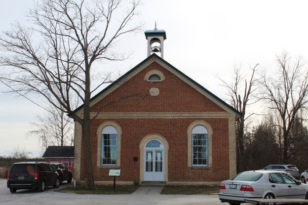
Saturday January 12, 2019

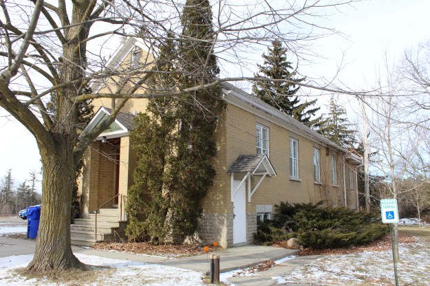
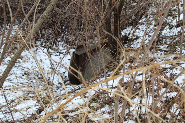
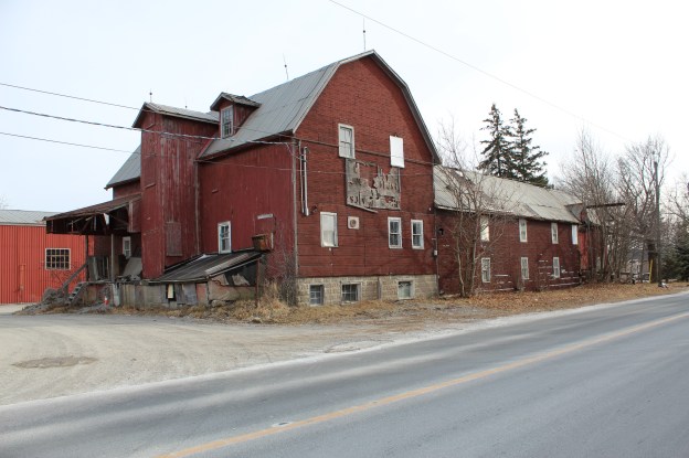
The community of Cedar Grove has become a ghost town compared to the former glory days in the 1800’s when it was a industrious mill town.  All four saw mills and both grist mills have disappeared leaving only the cider mill.  Peter Lapp erected the building in 1872 with the idea of taking advantage of the abundant local apple crops.  Lapp started making apple cider but soon added other products such as cider vinegar.  Lapps Cider Mill is considered to be one of the earliest and biggest examples of this industry in Markham.   The building is starting to show signs of disrepair after sitting vacant for years.  The front canopy has begun to droop badly and several boards have fallen away.  However, a steel roof has been added in the recent past indicating that someone had plans for the building.

img_0737

Two small dormers with six over six windows lit the upper floor of the mill.  These small glass panes are mostly intact with one just small fracture.  Just below the main roof line a small set of windows is broken out which lets the weather into the building.

img_0738

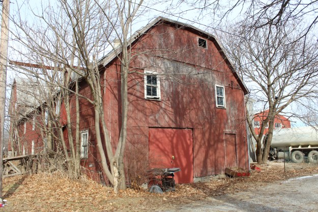
The elevator shaft had three doors, one for each interior floor.  Small lightning rods can be seen on top of the elevator and the corners of the roof.  Lightning rods are designed to carry energy from a potential lightning strike through a wire and into a ground rod where it can dissipate harmlessly.  The north face of the building has a frame construction with tightly spaced boards.  On the west side of the building a layer of Insulbrick has been added.  This was likely done in the 1920’s when this asphalt siding was at the height of popularity.

img_0739

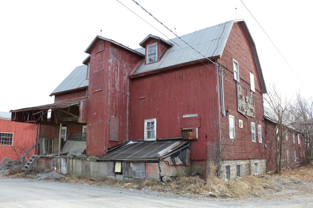
The west side of the building reveals something quite interesting.  The larger north end section appears to be a later addition.  This is suggested by the foundation which is made of precast concrete blocks that would not have been available in 1872.  This means that this end of the building was either raised onto the foundation or added after 1900.

img_0743

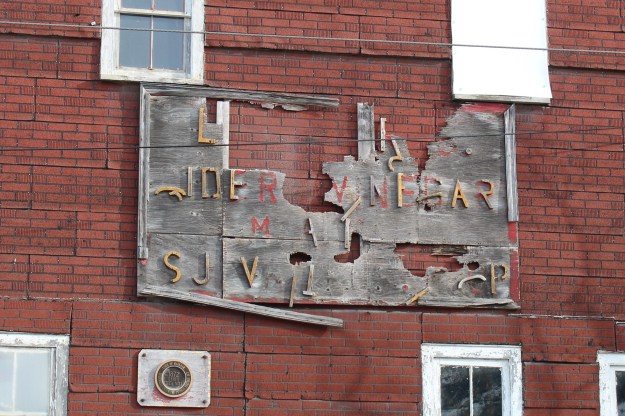
Ironically the plaque that announces this building is historically designated is attached just below the business sign that can only be partially read. Many of the letters have fallen off.  At Markham Museum there is another building known as Lapp’s Cider Mill.  It is a drive shed that was moved from a different Lapp property in Cedar Grove.  Lot 3 on the south side of Little Rouge Creek belonged to James Lapp who was the town blacksmith.  His blacksmith shop is now also on display at Markham Museum.  The press and other inner workings were moved from this building to the one at the museum where they are once again operational.

img_0744

The length of the hoist over the loading doors suggests that full orchard boxes of apples could be transferred from a truck into the mill.

img_0745

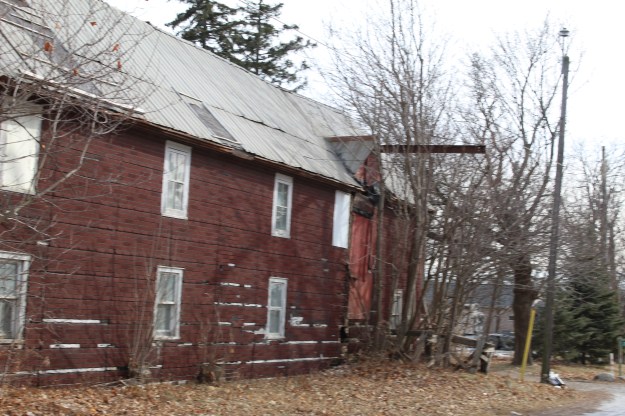
Two levels of loading doors with a provision for a hoist provide yet another access for snow and rain to enter the building.

img_0754

There is a set of ground level doors are at the south end of the building and once again we find more broken windows on the upper floor.

img_0757

It is truly a shame that this building appears to be slowly decaying.  You can read more about Cedar Grove in our story Cedar Grove – Ghost Towns of the GTA.

Google Maps link: Cedar Grove

Like us at http://www.facebook.com/hikingthegta

Follow us at http://www.hikingthegta.com


Cedar Grove – Ghost Towns of the GTA

Saturday, January 12, 2019

The area of Cedar Grove was first settled in 1790 but it really got going when the Reesor Family arrived and built the first mill on this part of Little Rouge Creek.  Within a few years Cedar Grove had four saw mills, two grist mills, a hotel, post office and general store and a blacksmith shop.  The community continued to prosper until the local wood supply was exhausted and the saw mills were closed down.  The hamlet was bypassed by the railway and a slow decline began.  Today Cedar Grove is part of Rouge National Urban Park and is specifically part of 470 acres known as Bob Hunter Memorial Park.  This park has several trails of which we chose the Reesor Trail.  The Monarch trail is 7.6 kilometres and will have to wait for another day to be explored. The Reesor Trail takes you along the Little Rouge Creek past the site of their mills.  Peter Reesor owned this property and his house was built of local field stone and was completed in 1832.

img_0717

Little Rouge Creek was partly frozen and in some places the open sections were just starting to glaze over.  The thin ice looked like plastic wrap spread over the surface of the water.  Water that is flowing has its potential energy converted to heat energy and thus it resists freezing at the molecular level.

img_0664

While walking through the trails it is easy to see why the area was named Cedar Grove.  With all the saw mills in the community they would have eventually exhausted the wood supply leading to the closing of the mills.  The areas along the creek have become reforested as their farming potential was limited.

img_0658

One of the more unique features is this former ring of water.  The last remains of a set of stairs can be seen below where it crossed the ring of water to the large island in the middle.  Many farmers created ponds to water their animals, perhaps that was the purpose of this construct.  A large clay pipe appears to have fed water into the channel.

img_0672

An old well sits a few feet away with a tin bucket that is rusted through.  The well has recently been boarded over.  A smoker or barbecue made of field stone sits a few feet farther along the trail.  Unfortunately, people have stuffed it full of garbage.  Perhaps that’s one of the reasons the well was closed off.

img_0678

White Tailed Deer do quite well in the GTA.  Most weekends we will either see deer or at least signs of their passing.  A recent study of Rouge National Urban Park suggested a herd of 85 – 95 in the park.  They have several large predators including cougars, alligators, jaguars and wolves, none of which are common in the GTA.  Packs of coyotes have been known to prey on fawns or any animal that is sick or has been injured.  Some would say that this improves the stock, over-all but it doesn’t sound very nice.

img_0777

Cedar Grove still retains plenty of remnants of the agricultural past.  Within the park area are two silos, the foundations for a barn and several old fence lines and roadways.

img_0716

Cedar Grove had three schools over the years beginning with a log school house on Steeles Avenue which was built in 1820.  Around 1850 it was decided to build a larger school one concession north.  A frame building was constructed on the north side of 14th avenue but it was replaced in 1869 with a brick building across the road.  This school had a gallery inside where adults could come and sit in on the teaching so they could learn as well.  The school lasted almost 100 years but closed in June of 1966 and the building now serves as Cedar Grove Community Centre.  The original slate chalkboards and gallery have been left in place as part of the heritage of the building.

img_0730

The community had several mills which have since disappeared.  One which survives in a couple of ways is Lapp’s Cider Mill.  The building is the last of the large industrial ones in town but the inner workings have been removed.  They are now in Markham Museum in their working cider mill.  The new mill is housed in the former Lapp drive shed that was on another of their properties south of the creek.  The Lapp blacksmith shop was also on this lot and has been moved to the Markham Museum as well.   There will be a separate mini-blog to feature more pictures and details of this heritage building.

img_0737

Beside the mill is an example of Edwardian Classicism architecture.  These four-square houses had two bays on two floors.  They also typically had a large dormer with two small windows in the attic.  This home is also on Lapp property and was likely added after 1910 at a time when the mill was still prosperous.

img_0756

The Cedar Grove Mennonite congregation officially formed in 1867 but they had been a presence in the community since Peter Reesor and family had arrived in 1804.  His mill lane ran from Reesor Road along the Little Rouge to the mills beside the creek and the house which still stands on the hill.  Samuel Reesor had erected the first building in 1861 but it was mostly used for funerals.  They were formally organized in 1912 and now have a newer building than the one shown below in which they house the Rouge Valley Mennonite Church.  In 1913 a deacon named Samuel G. Reesor died in the pulpit while praying

img_0762

In 1824 the first burial took place in what would become Cedar Grove Cemetery.  Many of the early settlers that built the community lie here including many members of the Reesor family.  The wrought iron arch was donated in 1966 by Elsie and Ira Reesor in honour of their parents.

img_0759

Across the street from the cemetery stands the skating rink known as Cedarena.  It continues to wait for skaters that haven’t shown up since it was closed four seasons ago.  More pictures and a detailed story can be found in our post Cedarena.

img_2011

Bob Hunter Memorial Park and Cedar Grove combined to make an interesting hike and we never had the chance to check out the 7.6 kilometre Monarch Trail.  I guess we’ll likely be back some day.

Google Maps link: Cedar Grove

Like us at http://www.facebook.com/hikingthegta

Follow us at http://www.hikingthegta.com

The Alexandria

Sunday, January, 6, 2019

There are estimates that over 6,000 ships have sunk in the Great Lakes.  Lake Ontario seems pretty calm but it has claimed over 200 ships since the arrival of Europeans.  One of those lies near the shore at the foot of the Scarborough Bluffs.  As it is the only one that can be easily located, it makes a great place to connect with a piece of our local history.

There weren’t very many birds out on this day but I did see a couple of  red-tailed hawks. One of them was hunting along the edge of the bluffs, riding the wind as it looked for food.

img_0569

The Doris McCarthy Trail runs from free parking on Ravine Drive down to Lake Ontario.  It descends about 90 metres over a length of 900 metres, making it a fairly steep trail.  The trail runs through a ravine known as Gates Gully which has a number of historical features, including the allure of buried treasure.  The trail gives great views of the lake as you make your approach to the beach.

img_0520

Sections of the beach trail can be pretty muddy but I think that is preferable to a shingle beach of eroded bricks.

img_0523

The Alexandria was a steamer built in Hull, Quebec in 1866.  The 508 ton vessel was over 170 feet long and 30 feet wide.  It was built as a freighter and later had passenger decks added in Montreal.  It worked the route along the north shore of Lake Ontario, occasionally making trips to Rochester, New York.  On this fateful night the ship was carrying 300 tons of sugar, beans, vinegar and tomatoes.

Wreck of the ferry Alexandria, Scarborough Bluffs. - August 2, 1915

On the afternoon of August 3rd, 1915 there was a storm raging with heavy winds blowing along the shore of the lake.  The steamer was blown closer and closer to the Scarborough Bluffs until it ran aground 200 yards from shore and began to sink.  Her crew of 22 was rescued and led to safety up Gates Gully.   The remains of the Alexandria are rusting badly and you can now see through several layers of metal near the waterline.  Eventually the parts of the ship that remain above water will rust away and slip into the lake leaving little trace of the majestic ship that lies below.

img_0539

For the next two days souvenir hunters scoured the beach carrying away anything that could be put to use.  Many people were able to fill up their pantry with food from the wreck.  Due to the extreme damage the ship had taken it was decided that there was no point in doing any kind of salvage work.   There is a lot of ship still below the waterline and in the 1930’s it was very popular to go diving around the wreck looking for artifacts.

img_0550

Waterbirds are common along the shore of the lake.  Mallards and Canada Geese can be seen on almost every visit.  Sometimes you get to see some of the less common ducks and there was a trio of long-tailed ducks swimming near the sunken steamer.

img_0540

This section of the bluffs is continuing to erode and the shore line has not been completely modified with armour stone.  This is one of the few remaining “natural” sections of the bluffs and we hope that current plans to modify it don’t come to pass.  Near the top of the bluffs a sign warning people to keep back from the edge because it isn’t stable, has itself fallen over the edge.

img_0534

The sky looked like our neighbours on the south side of the lake might not be having quite as nice of a day as we were.

img_0547

The view along the side of the bluffs is always interesting and ever changing.  It makes it worth returning time and again.

img_0561

The thing about visiting a site at the bottom of a hill is the certainty that you will have to climb back up.  With the slippery footing this was an interesting challenge.  In the summer this trail is a great place to jog or bike uphill to increase your stamina.

img_0577

The Scarborough Bluffs are a unique geological feature that we get to enjoy in the GTA and one of my favourite places to pass a few hours and enjoy being outside.

Google Maps Link:  Gates Gully

Like us at http://www.facebook.com/hikingthegta

Follow us at http://www.hikingthegta.com

Meadowvale Conservation Area

Saturday, January 5, 2019

Armed with the new camera I got for Christmas and the promise of a warm sunny day we set off for Meadowvale Conservation Area in Mississauga.  We have previously written about much of the history of the conservation area from the perspective of the various dams and berms associated with Silverthorne’s grist mill.  We won’t cover that again here and the link will be supplied again at the end of this story.  Today we were interested in the western side of the conservation area where the Toronto Suburban Railway used to run.  The Toronto Suburban Railway operated 5 electric commuter lines, including the one that ran up Yonge Street known as the Toronto & York Radial Railway   The line to Guelph was the longest in the system at 49 miles.  Stop 47 was a small station in Meadowvale after which the line crossed the Credit River and ran through the property that would become the conservation area.

When visiting the conservation area in the 1990’s there was quaint little suspension bridge that carried the pedestrian trail across the Credit River.  It was demolished in 2009 leaving only the metal posts on the river bank.  A decaying sign in the woods announces the removal of the bridge but it isn’t really needed any longer.  To see a picture of what the bridge looked like you can follow this link to a similar bridge in Warden Woods.

img_0364

My new camera allows me to get much better shots of birds and the cardinal in the photo below was only a small red spot to the naked eye.  I think I’m going to like having it along.

img_0417

The new bridge is a little farther south and considerably longer.  It crosses an area that is likely under water when the river is flooding.

img_0397

From the west end of the bridge there is a line that can be seen running horizontal through the woods.  This is the right of way for the former Toronto Suburban Railway.  The official opening of the railway came on April 14, 1917 and soon trains were running between Lambton and Guelph every two hours.  The trip lasted two and half hours and was very popular until the early 1930’s.  Rising costs, poor profits and a string of accidents coupled with a new love of the automobile led to the line being closed in August of 1931.  The tracks were removed in 1936 and in many urban areas the line has been built over with housing developments.

img_0400

The bridge that carries Old Derry Road over the Credit River was built in 1948.  It is known as a camelback truss bridge and is part of the Meadowvale Cultural Heritage District.

img_0420

The tail race for the Silverthorne grist mill joined the river just north of the bridge.  The tail race was crossed by the radial line near the last house on Willow Lane.  Both of the abutments are crumbling after 100 years with no maintenance.  This picture was taken at the time we explored the side of the conservation area with the mill foundations in it.

img_3041

The abutments for the crossing of the Credit River are still easy to locate a short distance north of the truss bridge.  The picture below shows the south abutment as seen from across the river.

img_0424

The last house on Willow Lane is undergoing a restoration.  The south abutment can be seen in the lower corner of the picture and the abutments for the crossing of the tail race are basically in the front yard.  With frequent passenger and cargo service this must have been a great place for train enthusiasts or a noisy place for anyone else.

img_0428

The abutment on the north side of the river has become completely overgrown with vines and must be all but hidden in the summer when the grass is full height.  Behind the vines the century old concrete is crumbling badly.

img_9384

Where the radial line ran through the park there are still about ten of the old electric poles standing.  The poles supported an overhead caternary system that delivered 1500 volt DC to power the cars.  They can be picked out because of their straight lines and flat tops.  In several cases the pole has a blue slash on it as can be seen on the extreme left in the cover photo.

img_0461

Fungus can still be found in the winter and it often adds colour and interesting patterns to what can be an otherwise drab landscape.  These turkey tail fungus entirely surrounded this old stump.

img_9394

The intersection of the radial line with the active Canadian Pacific Railway appears to lie somewhere under the six lanes of the new Derry Road.  North of Derry, the Samuelson Circle Trail continues on the old right of way.  The berm can be identified in many places along here because it rises a couple feet above the surrounding land.  Culverts allowed drainage from one side of the berm to the other and one can be found in this section.

img_0474

Cinnabar-red polypore can grow p to 14 centimetres in size and those pictured here are some of the larger specimens.  They grow all year and some will produce spores in the second and third years.  This fungus is not edible.

img_9398

Meadowvale Conservation Area is full of interesting historical artifacts for those who like to look for such things in the area in which they are hiking.  Many of these are associated with the Silverthorne Grist Mill which we covered in detail in a previous blog. The Guelph Radial Line has left only a few clues to the former right of way as it passed through the GTA.  A ghostly set of piers that cross the old mill pond in Limehouse is one example of interesting place to visit.

Google Maps Link: Meadowvale Conservation Area

Like us at http://www.facebook.com/hikingthegta

Follow us at http://www.hikingthegta.com