Monthly Archives: November 2017

Palermo – Ghost Towns of the GTA

Saturday, November 25, 2017

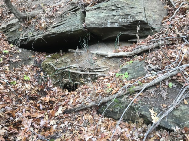
While investigating The Devil’s Cave we had the opportunity to drive through the former town of Palermo.  Today there are several historic buildings left but they are being threatened by the expansion of Oakville.  Widening of Bronte Road and then a bypass when highway 5 and 25 were moved has left the town with mostly empty buildings.

Palermo (2).jpg

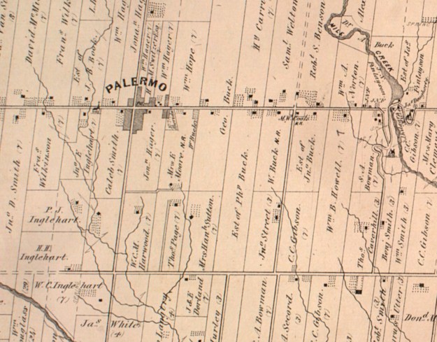
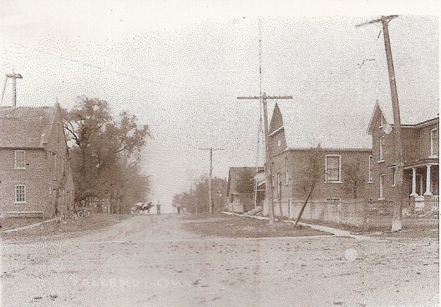
Lawrence Hagar arrived in 1805 and founded the town which was named Hagartown after him.  In 1836 it was renamed Palermo after Horatio Nelson,  Lord of Palermo.  The Lawrence Foundry and Agricultural Works was founded in 1842 and became the main employer in the new community.   The town grew quickly and by 1869 there were three hundred people living in the community at the intersection of Bronte Road and Dundas Street.   In addition to the usual blacksmith shops and hotels, they also had a harness shop, a wagon shop, and a brick schoolhouse.  Later the town included a telegraph company office as well.  The picture below shows the town around 1900.  The house in the foreground on the right remains but little else still does.  The foundry is on the left but it burned down in the 1950’s.

Palermo 1900

Lawrence Hagar built his original log home in 1805 and replaced it with a two-story Georgian home in 1848.  That home was listed as vacant in 2008 but has since been removed.  The third Hagar house was built in 1870 by Jonathan Hagar.  Jonathan had moved out of Palermo when he was 25 in search of fortune in gold mines in Australia and California.  When his father Lawrence died in 1857 he returned to Palermo to take over the family business.  The house also features a small barn that was constructed around 1900 to house the family horses.  The Hagar General Store stood just to the west of the house until it was removed for the widening of Dundas Street.  This property is currently being rezoned for a 10 story apartment building that appears to incorporate the house in the main entrance to the tower.  The house is registered with the historical society but does not have protection as a designated property.

IMG_1177

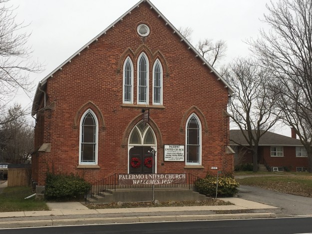
Lawrence Hagar was a devout Methodist and the first worship services in town were held in his home.  In 1824 land was deeded for a chapel on a property that had been used for a few burials beginning in 1813.  A chapel was built but when the Methodist Episcopal Church of Canada and the Wesleyan Methodist church of England merged there was a split in Palermo and for a while two chapels existed.  One was located on either side of the cemetery.  In 1867 work began on a new church to house both congregations.  The brick church was opened in 1869 with a steeple that has been removed since then.  The church is still active under the name of the United Church of Canada.

IMG_1178

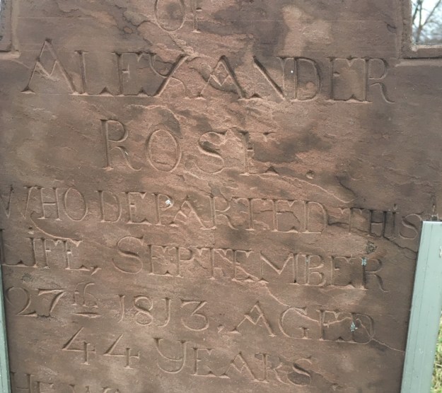
The cemetery has a surprising number of pioneer stones in it.  The first burial was in 1813 and we found this stone which reads in part: Alexander Rose who departed this life September 27th, 1813 aged 44 years.

IMG_1203

The present school is the fourth one to serve the community.  As early as 1819 there was a one-room log school in town.  It was one of only 3 schools in Trafalgar Township.  A brick school was built in 1842 and then replaced in 1875.  In 1940 this third school was damaged in a storm and many of the original materials were incorporated into the new building that opened in 1942.  The school building has the 1875 date stone incorporated into the back of the building.  It was closed in the early 1960’s and converted into the Palermo Police department.  Today it houses the historical society and has been registered but not given a historical designation.

IMG_1207

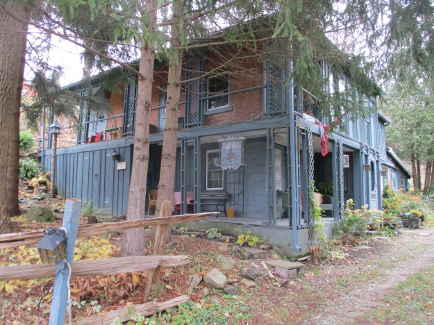
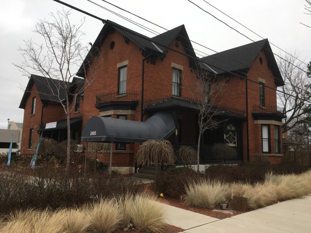
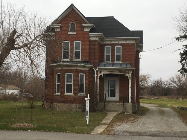
Dr Ansun Buck served the community for over 40 years.  He built a surgery in his house in the 1860’s and from there took care of the medical needs of Palermo and surrounding area.  Buck also designed one of the early bridges over Bronte Creek.  When he died in 1919 he was buried in the Presbyterian Church cemetery.  His house is an excellent example of Italianate architecture with a few Gothic touches to make it stand out.  This is one of only two houses in town that is designated as a heritage structure

IMG_1164

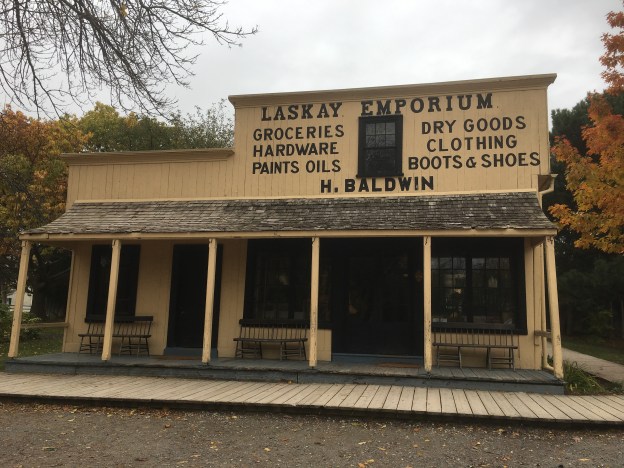
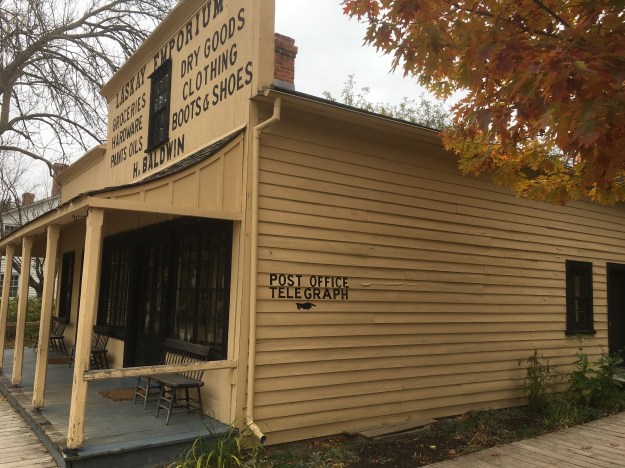
H. M. Switzer purchased 24 acres of land in 1861 and built this Italianate house in 1868. Switzer was the postmaster and a merchant in town.  This is the other house in town to have a heritage designation.

IMG_1179

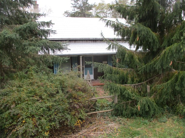
Caleb Smith built this house in 1875.  His father was Benjamin Smith who was the town carriage maker in 1806.  Smith built a large Georgian style house in 1822 that was the oldest home in Palermo.  It was allowed to deteriorate and it finally collapsed in 2007.  Caleb’s house is currently empty as are all the other original homes on the south end of Old Bronte Road.  I hope they restore it because it has some very interesting bracketing on the front porch.

IMG_1157

This gothic revival style house was built in 1880 beside the Methodist Church (now United Church).  It served as a parsonage for the next 32 years with one of the ladies groups being charged with preparing it for each new minister.  It was moved from the original location on Dundas Street to the present one on (old) Bronte Road around 1912 when the church sold it.  There appears to be a plan to restore and move some of the homes to save them but it is unclear which ones.

IMG_1165

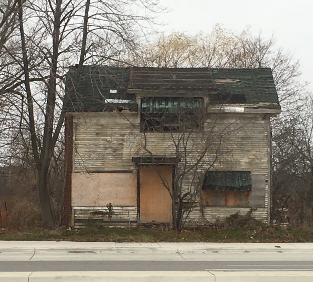
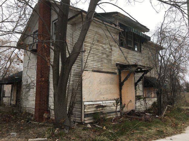
This house on Dundas Street is one of the few that really look like they should be decommissioned.  Rather, it looks to be in the process of collapsing as several other original structures in town have done.  The cover photo shows the front door to be off centre, perhaps it was some kind of store at one time.

IMG_1182

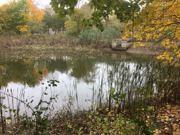
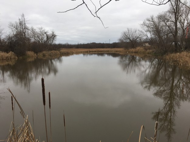
A park has always been central to Palermo life.  The park used to be on the west side of town but was in the way of the revised intersection for highway 5 and 25.  A new park with ball diamonds was created on the north side of Dundas Street.  There is a pond that stands between the schoolyard and the new park.  I imagine that there is no shortage of waterfowl in the summer months.

IMG_1194

It remains to be seen what will come of the original community of Hagartown which flourished under the name of Palermo.  I hope they don’t allow it to become a name on a signpost on a cemetery, commemorated by two or three original structures scattered among the new urban sprawl.

Google Maps Link: Palermo

Like us at http://www.facebook.com/hikingthegta

Follow us at http://www.hikingthegta.com

The Devil’s Cave

Saturday, November 25, 2017

On December 7th, 1837 William Lyon Mackenzie’s rebellion in Upper Canada was crushed and he was forced to flee to the United States to avoid arrest and trial for treason.  The story goes that he hid for the night in a cave north of Oakville before making his way to the border.   Locally the cave has become known as the Devil’s Cave.  An artesian spring in the back of the cave created a small pool which local school children came to call the Devil’s Pool.

The picture below is from the Oakville Archives and is believed to have been taken around 1915 on a school trip to the cave.  Where Bronte Road meets the present QEW was a community known as Merton.  The Merton school was known as SS #15 and was a log building until 1857 when a brick one was constructed.  It was demolished to make way for the QEW and the few remaining students were taken to Palermo starting in 1958.  We knew the cave had collapsed and couldn’t be entered but set out to locate it and see what remained.

Merton

As soon as we started moving through the grass on leaves we disturbed a number of small white moths.  Winter moths emerge from the ground between late November and the end of the year.  They are an invasive species of which only the male can fly.  The female crawls to the base of a tree where she attracts the male with her pheromones and then lays about 150 eggs in the bark.  In the spring the caterpillars hatch and begin to devour the leaves of maples, oaks and apple trees.  In the middle of the summer, the caterpillars go underground to pupate and emerge as moths in the fall.  They can kill a tree by removing the leaves for three years in a row.

IMG_1099

There are several distinct roadways and man-made berms as you descend the side of the ravine.

IMG_1101

This section of the ravine revealed a pioneer artifact in the form of an old saw.

Saw

There is a fisherman’s trail along the creek but you will need good footwear or you can count on wet feet and you make your way through several sections of wetlands and marsh.  The sides of the ravine have open seepage as water flows along the surface of the hillside.  There were still a couple of late-season salmon in the river although the run is basically over.

IMG_1102

There is a point where you will not be able to continue at river level due to the shale cliff that has been eroded into the embankment.

IMG_1114

Forced upward you will find the limestone to be full of fossils.  The limestone is full of holes which is evidence of karst activity, typical of the formation of caves.

IMG_1119

About 3/4 of the way up the hillside is the remains of the entrance to the Devil’s Cave.  It has collapsed some time ago and can no longer be entered.  Water flows out of the bottom of the old entrance, perhaps a legacy of the old pool inside the cave.

IMG_1127

Probing with sticks and flashlights showed that the cave extends farther than can be seen with the available light.

IMG_1133

At this point you will be forced to retrace your steps.

Like us at http://www.facebook.com/hikingthegta

Follow us at http://www.hikingthegta.com

Roblin’s Mill

Sunday, November 19, 2017

Black Creek Pioneer Village is built around the homestead of Daniel and Elizabeth Stong.  Their story and a brief history of the village can be found in this earlier post.  Once the decision had been made to collect historic buildings to allow people to glimpse the life the settlers lived it was time to identify potential buildings to put in the village.  Since most pioneer villages were founded around a saw mill, grist mill or woollen mill it was necessary to move a mill to the site at Steeles Avenue and Jane Street.

Owen Roblin took possession of a land grant not too far from Trenton that included a lake that came to be known as Roblin’s Lake.  Owen blasted a head race from the lake to a point where he could create a 75 foot head of water to turn his 30-foot overshot water wheel.  He divided part of his property to create town lots which were the beginning of the town of Roblin’s Mills.  He added a sawmill and carding mill and the town attracted blacksmiths, a harness maker hotels and a general store.  Today the town is known as Ameliasburgh.  The picture below shows the mill around the time it closed.  The building in the foreground is the carding mill and the water wheel is between the two buildings.  The head race runs under the road.  The building in the background with the sloping roof is the File Brothers General Store which closed in 1951.

Roblins-Mills-archive-photo

During the peak period around the time of the American Civil War, the mill was producing up to 100 barrels of flour per day.  Most of this was shipped to the northern states where it supported the army.  The mill was closed in 1920 and sat abandoned until 1965 when it was decided to demolish it.  The Toronto Region Conservation Authority (TRCA) was looking for a mill for Black Creek Pioneer Village and decided to purchase Roblin’s Mill and relocate it to the village.

IMG_0456

A mill pond was created at the village using Black Creek as a source of water.  There is a second mill pond behind the mill where the water goes after it flows over the water wheel.  This picture shows the upper pond and the entrance to the headrace which also flows under the road.

IMG_0492

The five-story stone mill was built in 1842 and soon became the focus of the community and included a post office.  As a commercial mill, it operated 24 hours per day with three run of stones.  The picture below and the cover shot show the open wooden flue that carries the water to the wheel.

IMG_0442

Inside, large wooden gears turned by the water wheel drove the three mill stones.

IMG_0480

Millstones relied on fine grooves that had to be dressed at least once a month when the mill was running 24 hours per day.

IMG_0468

Samples of grain and flour were moved from one floor to the other using these belts and cups.

IMG_0458

The ground flour was stored in dry barrels that were produced next door in the cooperage.  A dry barrel was less precise than ones known as wet barrels which were used for liquids such as whiskey.

IMG_0465

Black Creek has added the cooperage of John Taylor to their collection of buildings.  The building dates to the 1850’s and was moved to Black Creek Pioneer Village in 1976.  It wasn’t restored or opened until 1988.  Coopers often located next to mill complexes so that there was a ready market for their wares.

IMG_0450

Inside John Taylor’s Cooperage, you can see several types of barrels that were produced in the shop when it was located in Paris, Ontario.

IMG_0452

We close with an archive picture of the mill before it was moved to the village.

A1987_001_005_001

I have yet to see the mill in operation although I have purchased a bag of flour that was milled there.

Google Maps Link: Black Creek Pioneer Village

Like us at http://www.facebook.com/hikingthegta.com

Follow us at http://www.hikingthegta.com

Laskay – Ghost Towns of the GTA

Saturday, November 4, 2017

Laskay is not a ghost town in the formal sense because people still live there.  It was founded in 1832 when a dam was erected on the East Humber River to create a mill pond for a sawmill.  Joseph Baldwin took over the mill site that year when he bought the 100-acre property.  In 1849 he added a grist mill and later expanded with a woollen mill.  When he arrived the community had the nickname Bulltown but Baldwin changed the name to Laskay after his hometown of Laskay in England.

Laskay (2)


The Humber River was prone to flooding and the mill dam was often washed out.  The buildings themselves were destroyed in the floods of the late 1870’s.  By the time of the map above the sawmill was already gone.  The Grist Mill and Carding Mill are marked in blue.  Fires took out the rest of the mills and by the end of the century, they were all gone.

IMG_1652

Village lots were laid out on either side of the river on Joseph Baldwin and David Archibald’s lands.  From the 1850’s these lots began to fill up with workers from the mills along the river.  The town soon had a blacksmith whose shop once stood on Old Forge Road.  Travellers along 3rd line west (Weston Road) would seek a place to water their horses and wash the dust from their throats and beginning in 1845 they made Laskay Tavern a regular stop.  The tavern was built by Baldwin who constructed a general store and post office next door.  Adjacent to that, he built a dressmaking store for his wife to run, a business she shared with her sister.  The tavern is in use as a private home today.

IMG_1651

The town doctor lived in this house on the main street.  The side and rear of the house were planted with herb gardens used in various healing ointments and potions.

IMG_1655

The county atlas shows a Primitive Methodist church in the town in 1877, marked with red on the map.  The church itself was absorbed into the United Church of Canada and the building was eventually closed as a church.  Today it is marked by Old Church Road on which this interesting house can be found.  The walls contain double sets of buttresses with concrete caps as was common on churches around the turn of the past century.  It appears that the old wood structure was either replaced or given a new brick cladding around 1908.  Today most of the church structure is gone and a house stands amid the old walls.

IMG_1646

The Laskay Emporium is shown below and in the cover photo.  It was one of the main hubs of the community starting in 1856 when it was built.  It served the town as a general store and post office for nearly a century.  The store had a “Boom Town” front that hid the sloping roof from the street.  The veranda has a unique sloping roofline under which the locals would sit to watch the evening fade and smoke their pipes.  The Emporium closed and sat vacant waiting for demolition until February 19, 1960, when it was rescued and moved to Black Creek Pioneer Village where it is preserved.

IMG_0431

Joseph Baldwin’s son Henry was the postmaster for 20 years and part of his job was to sort the daily mail into the various slots on the post office pigeonholes.  The Post Office is designated with PO and marked in orange on the map.

IMG_0422

The emporium was the Walmart of the era, importing things and reselling them.  All the usual household needs could be bought here.

IMG_0406

Customers could buy milk by the cup for 2 cents or a lemon for 3 cents.  Three cups of sugar sold for 20 cents and eggs were 2 cents each. You could get four cups of flour for 20 cents, a cup of butter for 18 cents and baking soda for 5 cents.  For under a dollar you could get the ingredients to make a cake.  The cod for your main meal would cost you 8 cents.

IMG_0411

The Emporium was divided into three rooms on the ground floor with one serving in part as an office.  The post master’s desk and safe are seen in this picture.

IMG_0413

The third room was used to sell larger items and to unpack the crates of imported goods.  Beginning in 1852 the Ontario, Simcoe and Huron Railway began stopping at their new station in Springhill (King City) to deliver products from overseas as well as to allow local products, such as grain milled in Laskay, to be shipped to market. A selection of typical cookware is displayed in the rafters of the Emporium.

IMG_0418

One other building from Laskay has been preserved and that is Laskay Hall which was moved from the town to King Township Museum in 2017.  It was built in 1859 by the Sons of Temperance.  Since this museum also houses the railway station mentioned above, the oldest surviving railway station in Canada, it will certainly be featured in a future post.

Google Maps Link: Laskay

Like us at http://www.facebook.com/hikingthegta

Follow us at http://www.hikingthegta.com