Monthly Archives: November 2023

Kakabeka Falls – Thunder Bay

November 25, 2023

One of the best things about my job is the travel because I can incorporate an element of pleasure and tourism into my working time. I get to go to places like Thunder Bay to do inspections and then experience things things that I otherwise would never get to see. I have the opportunity to share them through this blog so that you can experience them vicariously from the comfort of your homes. It may even inspire a few people to visit them if they are in the area at some time in the future.

Kakabeka Falls is about 30 kilometers (19 miles) and less than a half hour outside of Thunder Bay just off of Highway 11 in Kakabeka Falls Provincial Park. It is located on the Kaministiquia River where the water plunges 40 metres (130 feet) into a gorge cut into the shale. The falls are continually eroding the shale and have been doing so since the end of the last ice age 12,000 years ago. This shale is very unstable and contains some of the oldest known fossils on the planet. Some of these are dated back to 1.6 billion years ago. The name is an Ojibwa one which means “waterfall over a cliff” and it has taken on the designation of Niagara Falls of the north.

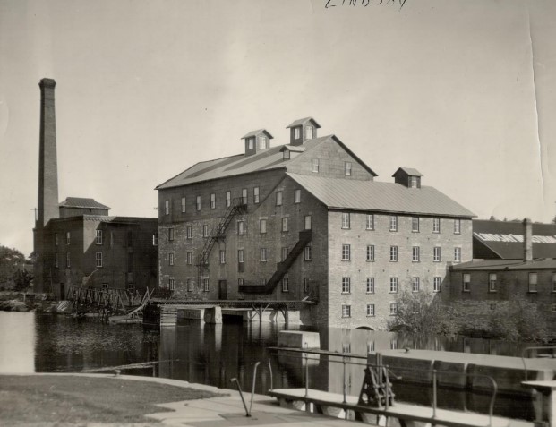
There are two distinct steps in the falls and the water flow was pretty good during my visit. In the winter the falls can freeze over and there used to be a hotel on the edge of the gorge that would get coated in ice in the winter. When the 5 square kilometre provincial park was created in 1955 the hotel was removed. The river was a major route that was used to get access to the north west and a mountain portage existed to get around the falls. It connected Lake Superior with Lake of the Woods and was used for centuries by the Indigenous peoples and later by the fur traders.

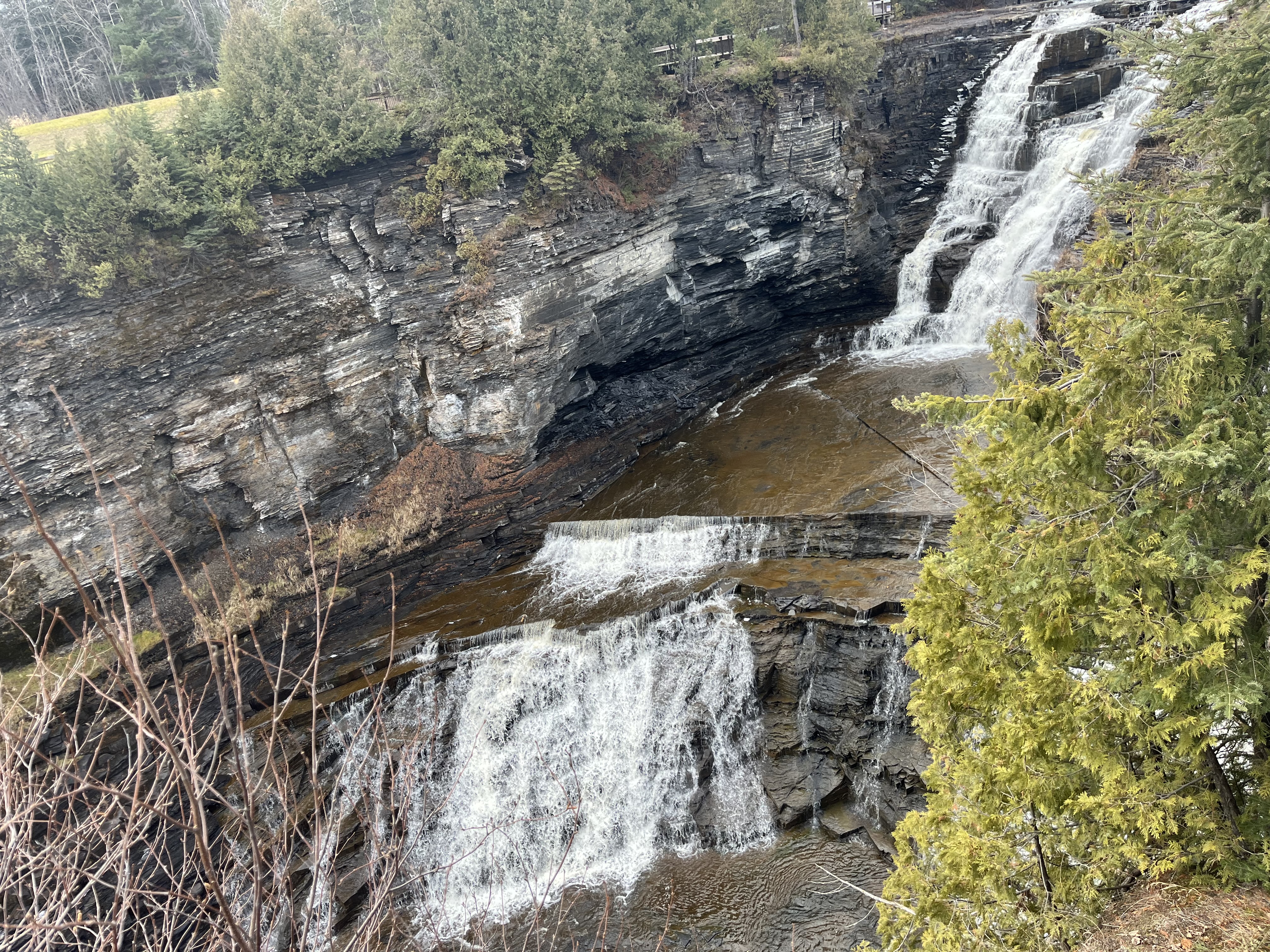
There’s a footbridge that lets you cross the river and look out over the brim of the falls. Notice how small the river looks as it appears in the distance, deep in the valley.

The falls have an Indigenous tale attached to them. According to legend, an Ojibwa Chief found out about an imminent attack from a band of Sioux and decided to try and prevent it. He asked his daughter Green Mantle to help him protect his people and she devised a plan to do so. She is said to have infiltrated the Sioux camp and acted as if she was lost. She bargained to save her life by promising to lead the Sioux to her father’s camp. Instead she tricked them into going over the falls in their canoes. She allegedly died along with them and now her spirit can be seen in the in the mist of the falls. Another version of the story suggests that she jumped out of the canoe at the last minute and saved herself by swimming to shore.

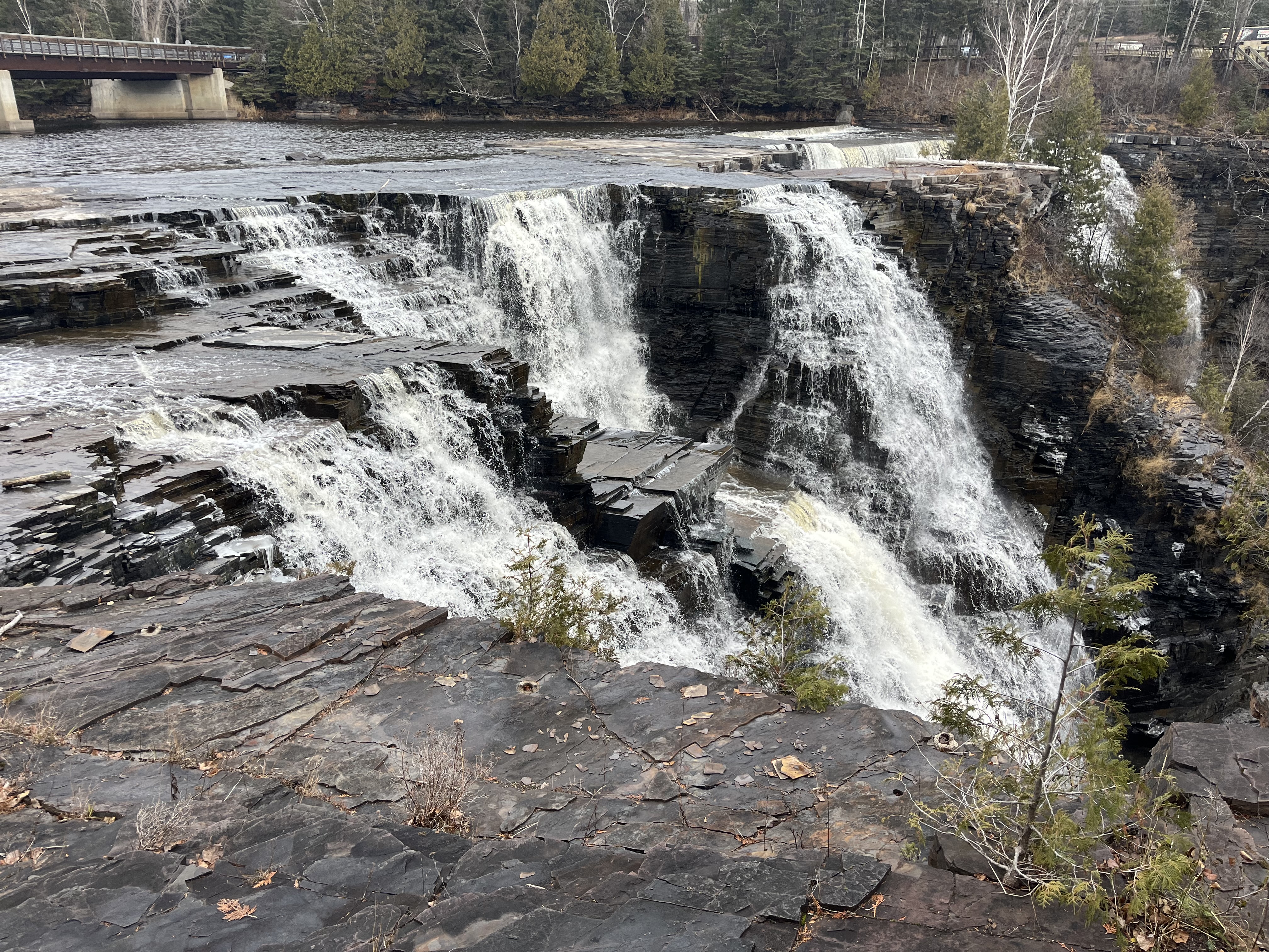
There is a boardwalk that allows you to walk along the gorge on either side of the falls and has several viewing platforms. Access is not permitted inside of the boardwalk due to the unstable shale along the sides of the gorge and no one is allowed into the gorge at the bottom of the falls.

Aside from the falls there are 17.9 kilometres of hiking trails in Kakabeka Falls Provincial Park including Little Falls Trail. This trail leads to a separate waterfall which I didn’t have time to explore during this visit but which I will plan to explore on my June trip next year. There’s also two campgrounds which combine for 169 campsites of which 90 have electricity. Cross-country skiing is available for the winter months.

Day use of the park is $6.50 per car and is well worth it, especially if you use the guided hike and interpretive programs.

Related Stories: Niagara Falls

Google Maps Link: Kakabeka Falls

Like us at http://www.facebook.com/hikingthegta

Follow us at http://www.hikingthegta.com

Also, look for us on Instagram

The Old Mill – Lindsay

November 18, 2023

Lindsay has a lot of history and while there on a business trip I took a visit to the Old Mill Park to view the remains of the mill. This structure is nothing compared to what it used to be but it is still a prominent feature in downtown Lindsay and was highly instrumental in the development of the town. The original land grant for the site included Lots 20 and 21 in Concession 6 which had been set aside as a potential mill site during the surveying of Ops Township.

William Purdy had been operating a large mill in Vaughan which was destroyed in 1828 and he applied for the land grant at the future site of Lindsay. His plan was to start in 1829 and have the mill operational in 1831. When his dam was destroyed in flooding in the spring of 1831 he was set back a couple of years and the mill didn’t open until 1833. As the mill prospered, the community that grew up around the mill came to be known as Purdy’s Mills. Town lots were laid out in 1834 and other industries started to come to the area including blacksmiths, hotels and taverns and a carding mill. The mill dam backed up the water flow and created Lake Scugog which upset the property owners that got flooded out. It also created a lot of breeding ground for mosquitos and so after many useless protests to the government the locals took matters into their own hands in 1844 and destroyed the dam. The mill dam was rebuilt and starting in 1869 the mill was replaced with a stone structure on a new foundation. The image below from the Lindsay Archives shows the the mill around 1900 when it was at its peak of production.

Kent Street was laid out in 1840 and it started to fill up with commercial and residential properties. In 1844 Purdy sold the mill to Hiram Bigelow who operated it until 1861 when it was destroyed in a large fire. The fire burned 91 of the wooden buildings in town and was a major setback for the mill. It wasn’t replaced until a new stone structure was built in 1869. This is the current building whose lower floor is all that remains in Old Mill Park. The image below shows the old wooden door which is interesting because the vines that now grow inside the building have found their way through the cracks to grow up the outside of the building.

The mill was run by William Needler and Thomas Sadler until it was sold to the Flavelle Family in 1884. Starting in 1899 it was rebranded as the Flavelle Milling Company.

The company went through several restructuring activities in the 1910s and Flavelle Milling Company was part of a merger of eight mills in the 1920s. The mill saw its peak production in 1904 but by the mid 1920s it was closed.

It reopened in 1927 as Lindsay Distillery but this only lasted until 1930.

In 1946 it was opened again, this time as Henderson’s Chick Hatchery. This venture lasted until 1971 when the building was vacant again.

There was a proposal to repurpose the structure as an accommodation facility of some type but when a $100,000 fire broke out in 1978 it was the end of the useful life of the building.

The mill dam is still in place and the remains of the building have been owned by the town since 1981.

It was recommended that the building be demolished in 1986 but instead the town has paid to stabilize the remains by capping the walls with cement. There have been a series of proposals to save the structure and develop it into something of a historical nature including a museum.

The old mill is currently a popular place for wedding pictures and is the focal point of the park but it still waits to see what its ultimate destiny will be.

Google Maps link: Lindsay Mill

Like us at http://www.facebook.com/hikingthegta

Follow us at http://www.hikingthegta.com

Also, look for us on Instagram.

Battle of Crysler’s Farm – Nov. 11, 1813

Nov. 11, 2023

As the second year of the War of 1812 drew to a close the Americans wanted to try to capture Upper Canada by taking Montreal and cutting off supplies to all of the area west of it. US Secretary of War John Armstrong developed a plan to use two armies to converge and take the city. General Wade Hampton was marching from Lake Champlain with his forces and Major General James Wilkinson was ordered to set sail from Sackets Harbor to join him. Wilkinson left Sackets Harbor on October 17, 1813 to sail down the St. Lawrence River to join forces with Hampton. British gunboats under William Mulcaster harassed the American fleet and fired shots at them before heading to Kingston to sound the alarm. Wilkinson became ill and ended up delegating responsibility for the army to Brigadier-General John Parker Boyd.

On November 10th Boyd set up his headquarters at a local tavern and
the British under Lieutenant Colonel Joseph Wanton Morrison were camped just a couple of kilometers away at John Crysler’s farm. Crysler was a wealthy loyalist and the leader of the Dundas Militia. The night was one of sleet and rain and many of the British troops slept outside with no protection from the weather.

On November 11, 1813 the British troops began an attack on the American position but it was unsuccessful and they were driven back. Subsequent American attempts to attack were repulsed as the infantry were overpowered by volleys from the well-trained and practiced muskets of the British 49th and 89th Regiments of Foot, which made up the bulk of Morrison’s army.

In order to attack the Americans were forced to cross two ravines and then navigate a field which was full of split rail fences. The canon in the image above has a date carved on the housing which reads 1800.

Boyd gave contradictory and inconsistent leadership which led to the confusion and lack of discipline among the American infantry. Most of the American soldiers ran out of ammunition and began to retreat before the calvary arrived as a back-up. Meanwhile the British maintained discipline and held their lines to deliver volley after volley of musket fire at the advancing American army. Boyd eventually called a retreat and the American troops fell back to French Mills for the winter. This was the last battle of the year in the war and the Americans had failed to make any serious advance in their efforts to capture British North America. The image below shows a replica 6 pounder muzzle loading gun similar to ones used by both sides during the battle. It could fire a six pound ball for 1200 yards.

The British forces were much smaller but managed to kill 340 men and capture another 100 while losing a little under 200 soldiers of their own. A monument to the battle was erected on Crysler’s Farm in 1895 and a bronze plaque was added in 1923 to commemorate the battle.

In 1958 Crysler’s Farm was flooded during construction of the St. Lawrence Seaway and the monument was moved. Soil from the site of the battle was dug up and used to build a mound on a plot of land near Upper Canada Village. The monument was placed on this new mound of soil and continues to look out over the former battle site, now under water.

In 1959 a small interpretive centre was built to describe the history of the battle and in 2012 a new visitor centre was built. Each year re-enactors come together to commemorate the battle.

Although Remembrance Day is usually considered as respect for those who fought in the First and Second World Wars, it is interesting that it also falls on the anniversary of this pivotal battle from the War of 1812.

This is the fifth installment in our War of 1812 series which may eventually extend to all the Canadian battle sites.

Associated Stories in our War of 1812 series: Battle of York, Battle of Queenston Heights, Battle of Stoney Creek, Battle of Beaver dams.

Google Maps Link: Crysler’s Farm

Like us at http://www.facebook.com/hikingthegta

Follow us at http://www.hikingthegta.com

Also, look for us on Instagram

Box Grove – Ghost Towns of the GTA

November 4, 2023

Families started to arrive in the area of present day 14th Avenue and 9th Line near Markham as early as 1815. The Tomlinson and Beebe families were among the first to move there and begin to develop farms and mills. In 1850 they put forth a plan to develop the community by selling lots for residential use. The lots were either 100 or 250 feet wide by 250 feet deep. This was intended to provide housing for the workers in the saw mill, woollen mill and shoddy mills. A shoddy mill reclaimed used fabrics to make paper or mattress stuffing materials. The community was known as Sparta or Sparty Wharf and was the last point on the Little Rouge River that could be easily navigated. The development soon let to the arrival of three hotels and taverns, a cheese factory, a blacksmith and two axe makers. The image below is taken from the 1877 County Atlas and shows the community in relation to nearby Cedar Grove.

In 1850 The Episcopal Methodists had built a small church in the town and continued to worship there until 1877 when their new building became available. They continued as a Methodist Church until 1925 when they became the Box Grove United Church. In 2004 the church congregation voted to join the Zion United Church in nearby Cedar Grove. The building was vacated and then bought by the Full Gospel Assembly of God in 2006 who continue to meet there on Sundays.

A half acre of land was set aside for the Methodist cemetery in 1850 and many of the town settlers are buried here.

From the County Atlas above you can see that the school is shown across the street from the present structure. This small frame structure had become too small and needed to be updated. School Section #18 was replaced with this red brick structure in 1877, the same year the county atlas was produced. This new schoolhouse was used until the 1960s when new buildings were opened and most of the one room schools in Ontario were closed. Today the old school serves as a community hall and can be rented for various functions such as parties and wedding celebrations.

In 1867, the year of Confederation, they were awarded a post office and the town name was changed to Box Grove. The post office was in the general store which was located in the building seen below.

With three taverns and a population of 150 the town had a bit of a reputation for being rowdy. The Mennonite families on surrounding properties were not pleased and soon opened a Temperance Hall. All of the original industry disappeared and only the homes remained along with the school and church. There are still quite a few mid to late 19th century houses lining the streets around the original intersection. The one pictured below is a typical one and a half story worker cottage.

The house below was originally built in 1880 using a roughcast stucco surface applied to lathing. It has since been covered over with wooden siding. It was built on the Reesor Family farm on the east end of town and may have housed the person who operated their cheese factory. The house was modified at some point adding the western wing and making the home into an L shaped building. When the farms around Box Grove were redeveloped for housing the home was moved to make way for stormwater ponds.

One of the few homes in Box Grove to still display its original brick veneer with buff coloured accents stands on the eastern edge of the original town.

In the past few decades the area has been developed with new housing but the older ones can be picked out as you walk or drive through the neighbourhood.

In 1950 Nelson Morgan Davis, one of the richest men in the country, created a golf course in Box Grove which he called the Box Grove Golf Course. It was private and he was the only member. It was eventually developed into a 27 hole course with 9 holes in the valley and a challenging 18 hole course on the tableland above. It is said that he built the course after being hit in the head by a golf ball while playing at Rosedale Golf Club. Arnold Palmer was invited to play a round of golf with Davis and he later said that the course was one of the hardest he had ever played. Davis sold the golf course to IBM in 1967 netting a cool $2 million for it. IBM kept the course for the entertainment of its employees who could play a round of golf for $5.00. In 1997 IBM sold the golf course to Minto Developments who built a residential subdivision on the upper course while the City of Markham now operates a nine hole course in the river valley called Markham Green.

The Little Rouge River was dammed to create a mill pond to store water to power the mills that provided early industry in the community. The mills were all lost to flooding or to fires but the mill pond remains and is now the centre attraction for the Old Mill Pond Park which is just one of the parks in and around town. The town also features some hiking trails along the river.

Box Grove has been swallowed up by modern developments but there’s still quite a number of early residences hiding along 9th line and along 14th avenue.

Related Stories: Cedar Grove, The Reesor Family

Google Maps Link: Box Grove

Like us at http://www.facebook.com/hikingthegta

Follow us at http://www.hikingthegta.com

Also, look for us on Instagram