Tag Archives: War of 1812

Oro African Methodist Episcopal Church

Feb.3, 2024

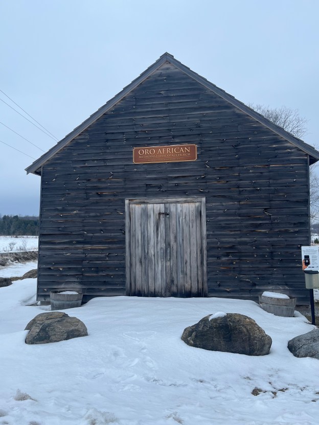
The Oro African Methodist Episcopal Church is a National Historic Site that was designated in 2000. It is the last remaining building in an African Canadian community that was developed in Oro Township between 1830 and 1850. The idea of such a community was first proposed in 1783 by Sir Guy Carlton who was the Commander-in-Chief of British forces in North America. It was thought that integrating African Canadians into a farming community would allow them to settle into a new life in British North America. Carlton had promised freedom to slaves of the American Revolutionaries who fought on the side of the British during the American War of Independence. Many of these people also fought during the War of 1812 under Captain Runchey’s Company of Coloured Men. The 1877 County Atlas image below shows the location of the church as well as a property owned by one of the members. In an apparent act of racism, only the white settlers names are recorded on the map and so I have marked the property of George A Darkman on it as he is featured in this story as an example of the individuals that made up the church. By the time of this map, it was no longer property of the family.

Between 1819 and 1826 twenty-five black men were granted 100 acre plots of land in Oro Township by the British. Eleven of these got their grants in acknowledgement of miliary services. Of these 25 only nine of them would take up their grants and these were along a section of land on Line 1 known as Wilberforce Road. This road was named after the British Abolitionist William Wilberforce who was a politician who fought in British Parliament for the abolishment of slavery in the British Empire. Between 1829 and 1831 another 30 families moved into the community.

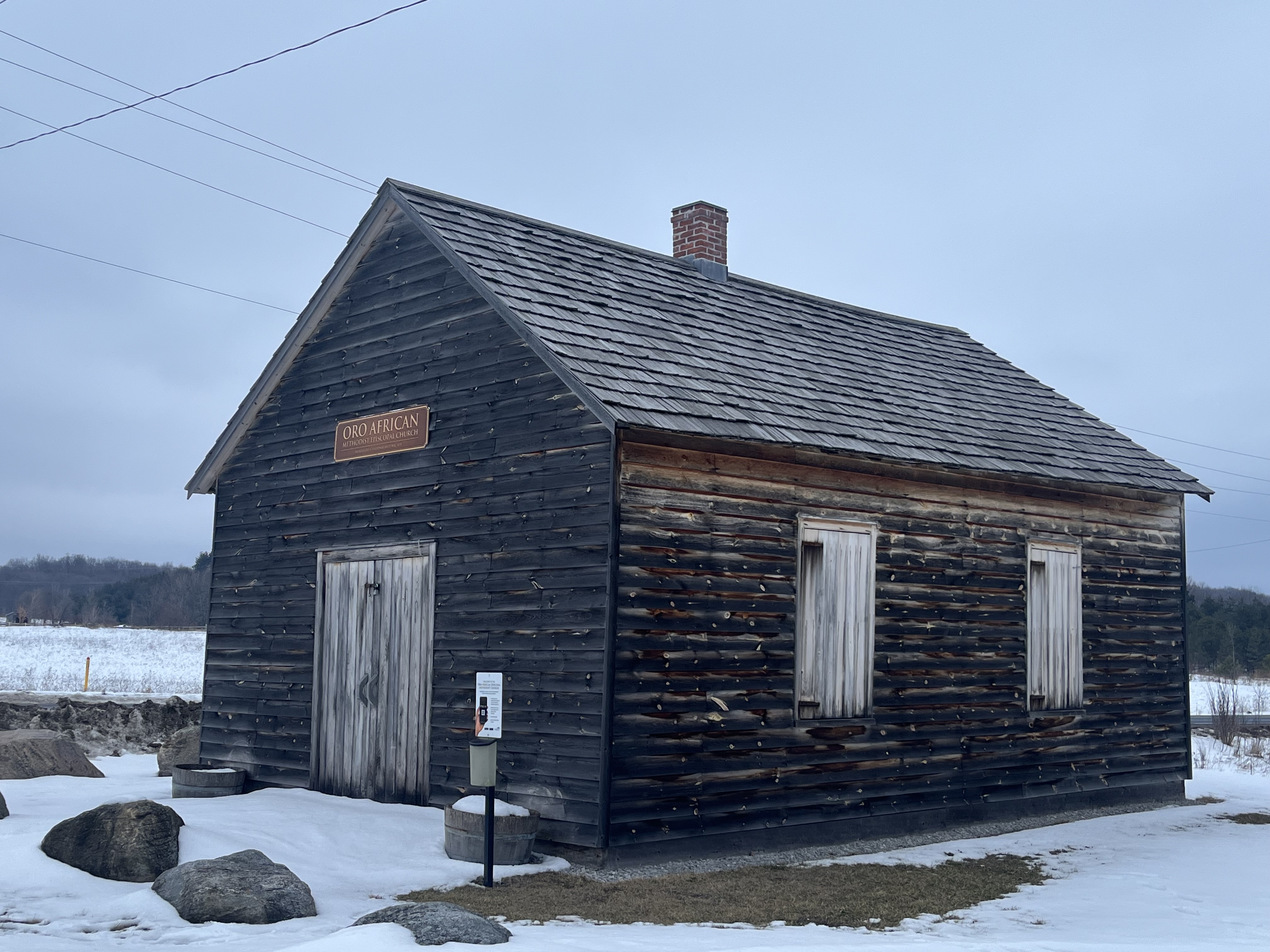
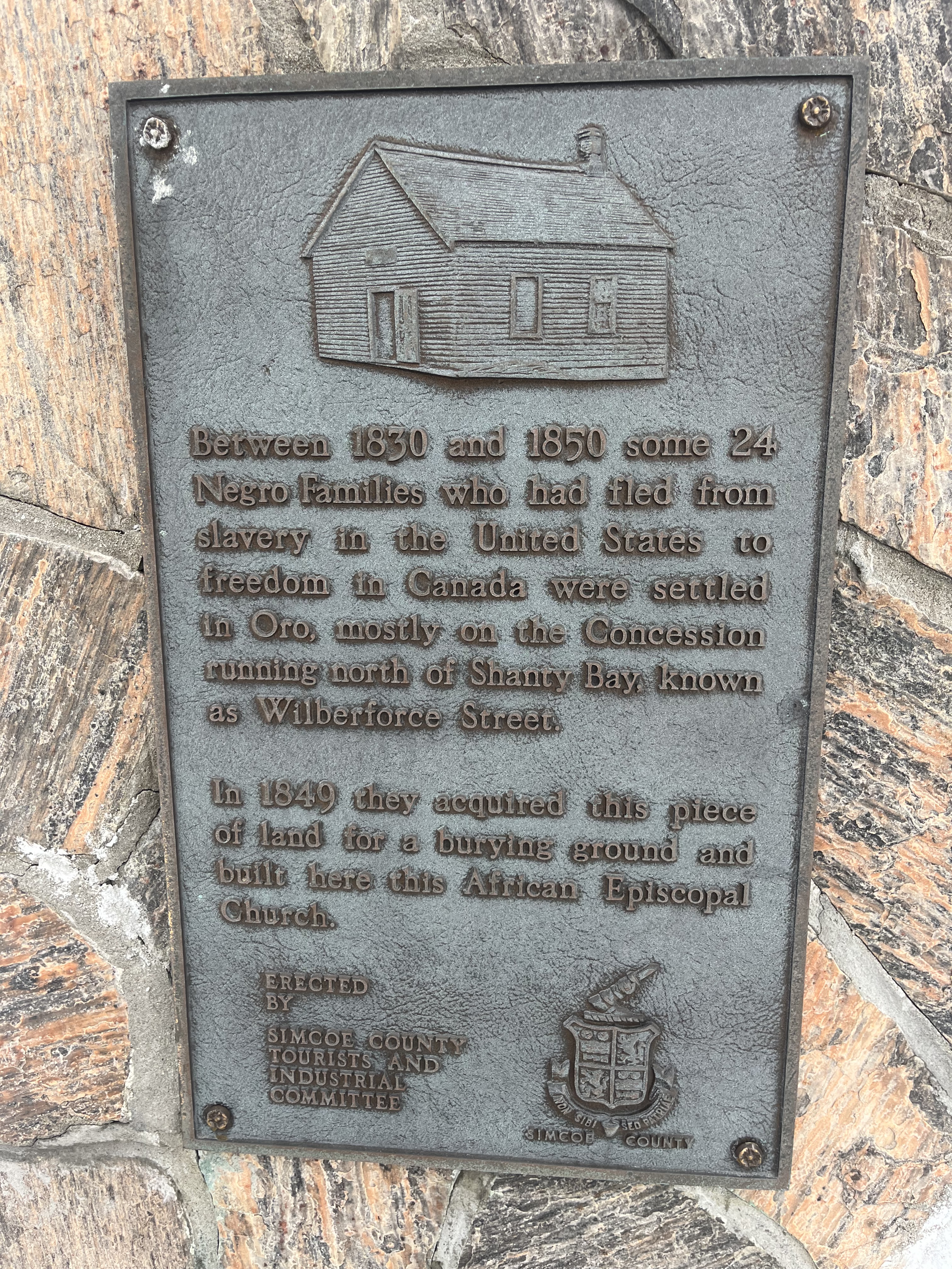
A one-acre parcel of land was acquired for use as a burial grounds and to build a church for the community. The church was built in 1849 out of hewn logs which were covered on the outside with clapboard about 10 years later to help keep out the wind and cold weather. By 1900 the community had declined as many of the settlers took advantage of Lincoln’s Emancipation Proclamation. This allowed former slaves to return to the USA and many of the settlers went in search of long lost family members. The British Methodist Episcopal Church declared the building abandoned in 1916 although services were continued until the 1920s.

The building fell into a state of disrepair and by 1947 it was in such poor condition that the local descendants of the original settlers feared that this piece of history would be lost. Efforts were made to restore it with further repairs being made in 1956 and again after vandalism in 1981 when two stolen dump trucks were smashed into the building leaving it seriously damaged.

One of the members of this church was simply known as George. He was born into slavery in Virginia sometime around 1769 and came to Canada prior to 1812. He was one of the soldiers who served in Captain Runchey’s Company of Coloured Men. White settlers were granted 200 acres but black ones were only given 100 acres. George petitioned for a land grant based on his service in the War of 1812 and was granted Lot 15 on concession 2 in Oro Township. In order to receive the land patent it was required that he have a full name and so displaying a sense of humour, he chose George A. Darkman. George left his property to his wife and two children who still lived in the USA and his will is recorded as being the first will to be probated in Oro Township. The will stated that his family had to come to the property within five years and sadly they never made it. Perhaps they were still enslaved themselves. The provision was made that if they didn’t come it would go to a white friend of George, and this is what transpired.

The church was declared a National Historic Site in 2000 but was still left to slowly deteriorate yet again. A cultural heritage assessment was conducted in 2013 and a preservation plan was put into place in 2015. The floor needed to be stabilized and the ceiling joists were reinforced. New cedar shingles were put on the roof and some of the clapboard was replaced. One of the most interesting discoveries during this restoration project was the fingerprint of one of the original settlers which was preserved in the plaster chinking between the logs.

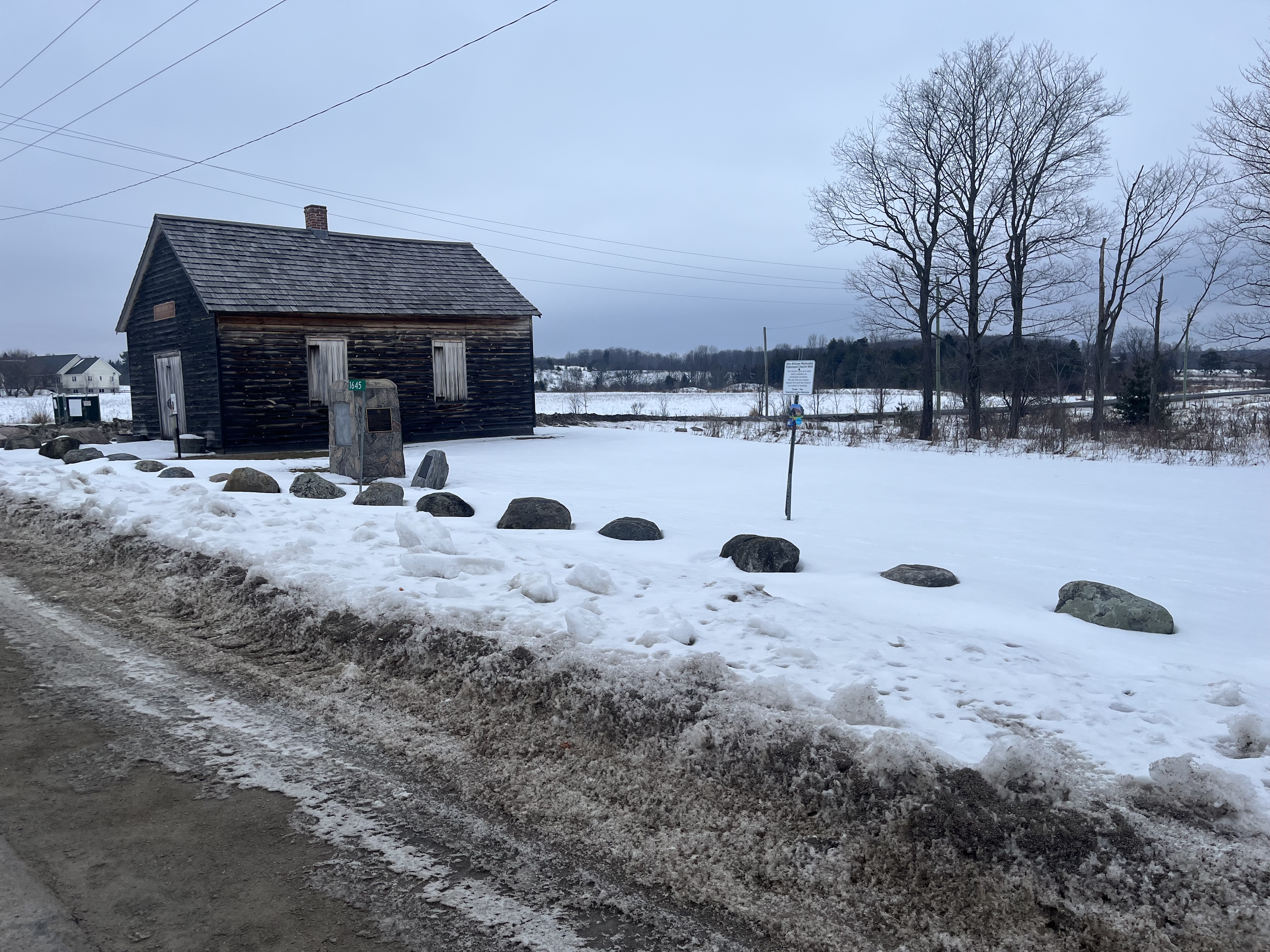
An unmarked graveyard lies in the south part of the property and a cairn was added in 1947 to identify the names of 24 families buried there. 

This church is perhaps the oldest surviving log church from a black congregation in North America and it is fortunate that it has been preserved to help maintain the memory of this important chapter in our shared history. For further reading on early black settlers, see our feature on Griffin House. Also, enjoy our story about Turner Chapel, another African Methodist Episcopal Church. 

Related Stories: Griffin House, Turner Chapel

Google Maps link: Oro African Methodist Episcopal Church

Like us at http://www.facebook.com/hikingthegta

Follow us at http://www.hikingthegta.com

Also, look for us on Instagram

Prescott Waterfront

December 23, 2023

A recent trip to Eastern Ontario gave me the opportunity to visit Prescott to find some lunch and take a break from driving for a hour or so. I used my time to wander along the Heritage River Trail and see some of the local history of the waterfront. Prescott was named after General Robert Prescott who was the Governor of Canada from 1796 to 1799. Col. Edward Jessup had received a large land grant for his loyalty and service during the American Revolutionary War and in 1810 laid out the streets for a new town on the side of the St. Lawrence River. Within a decade the town had grown to about 50 houses and had several businesses including stores and taverns.

Just two years later the War of 1812 broke out and part of the town was reclaimed by the Government to build Fort Wellington. It was commissioned in 1813 to guard the Galop Rapids in the St. Lawrence. Following the war it was abandoned by the British but officially remained the property of the British Board of Ordinance. It was used by the Canadian Militia until 1923 when it was handed over to the Dominion Parks Commission, which was later renamed Parks Canada. It has been a National Historic Site since 1920. This fort will be an interesting place to explore on a future visit to the area.

The population of Prescott had grown to about 1700 by 1834 and it became the site of the Battle of the Windmill during the Rebellion of 1837.

A railway was established from Prescott to Ottawa in 1854 and soon the waterfront was a hub of railway activity. A roundhouse, railway station and ferry terminal were added soon afterwards. The town became the centre of a major ferry link to the United States. The Canadian Pacific Railway continued operations at Prescott until the 1970s when things were shut down. The piers from the railway terminal are still located in the water and can be seen below and in the cover photo,

A building made of red bricks was built in 1900 by the Imperial Starch Company and it served as a lighthouse. Between 1903 and 1985 it was known as The Dominion Lighthouse Company. The building was used for the production of war materials during the Second World War and then occupied by the Coast Guard from 1962 until 1985. After the Coast Guard moved out, the building was demolished in 1986. The large lantern room housed a Fresnel Lens and the room and lens were saved from demolition. A Fresnel Lens is compact compared to a conventional lens and reduces the amount of materials used by having a series of concentric surfaces. The lens had been used to train lighthouse keepers and it was installed on top of a new tower that the Rotary Club built in 1989.

The Great Lakes Waterfront Trail runs along the St. Lawrence River as part of its 3600 kilometer span but the section through Prescott is also known as the Heritage River Trail due to all the history that is located along the route through town.

Prescott has many historic building as well as Fort Wellington and I look forward to checking out more of them during a future work trip to the area.

Google Maps Link: Prescott

Like us at http://www.facebook.com/hikingthegta

Follow us at http://www.hikingthegta.com

Also, look for us on Instagram

Battle of Crysler’s Farm – Nov. 11, 1813

Nov. 11, 2023

As the second year of the War of 1812 drew to a close the Americans wanted to try to capture Upper Canada by taking Montreal and cutting off supplies to all of the area west of it. US Secretary of War John Armstrong developed a plan to use two armies to converge and take the city. General Wade Hampton was marching from Lake Champlain with his forces and Major General James Wilkinson was ordered to set sail from Sackets Harbor to join him. Wilkinson left Sackets Harbor on October 17, 1813 to sail down the St. Lawrence River to join forces with Hampton. British gunboats under William Mulcaster harassed the American fleet and fired shots at them before heading to Kingston to sound the alarm. Wilkinson became ill and ended up delegating responsibility for the army to Brigadier-General John Parker Boyd.

On November 10th Boyd set up his headquarters at a local tavern and
the British under Lieutenant Colonel Joseph Wanton Morrison were camped just a couple of kilometers away at John Crysler’s farm. Crysler was a wealthy loyalist and the leader of the Dundas Militia. The night was one of sleet and rain and many of the British troops slept outside with no protection from the weather.

On November 11, 1813 the British troops began an attack on the American position but it was unsuccessful and they were driven back. Subsequent American attempts to attack were repulsed as the infantry were overpowered by volleys from the well-trained and practiced muskets of the British 49th and 89th Regiments of Foot, which made up the bulk of Morrison’s army.

In order to attack the Americans were forced to cross two ravines and then navigate a field which was full of split rail fences. The canon in the image above has a date carved on the housing which reads 1800.

Boyd gave contradictory and inconsistent leadership which led to the confusion and lack of discipline among the American infantry. Most of the American soldiers ran out of ammunition and began to retreat before the calvary arrived as a back-up. Meanwhile the British maintained discipline and held their lines to deliver volley after volley of musket fire at the advancing American army. Boyd eventually called a retreat and the American troops fell back to French Mills for the winter. This was the last battle of the year in the war and the Americans had failed to make any serious advance in their efforts to capture British North America. The image below shows a replica 6 pounder muzzle loading gun similar to ones used by both sides during the battle. It could fire a six pound ball for 1200 yards.

The British forces were much smaller but managed to kill 340 men and capture another 100 while losing a little under 200 soldiers of their own. A monument to the battle was erected on Crysler’s Farm in 1895 and a bronze plaque was added in 1923 to commemorate the battle.

In 1958 Crysler’s Farm was flooded during construction of the St. Lawrence Seaway and the monument was moved. Soil from the site of the battle was dug up and used to build a mound on a plot of land near Upper Canada Village. The monument was placed on this new mound of soil and continues to look out over the former battle site, now under water.

In 1959 a small interpretive centre was built to describe the history of the battle and in 2012 a new visitor centre was built. Each year re-enactors come together to commemorate the battle.

Although Remembrance Day is usually considered as respect for those who fought in the First and Second World Wars, it is interesting that it also falls on the anniversary of this pivotal battle from the War of 1812.

This is the fifth installment in our War of 1812 series which may eventually extend to all the Canadian battle sites.

Associated Stories in our War of 1812 series: Battle of York, Battle of Queenston Heights, Battle of Stoney Creek, Battle of Beaver dams.

Google Maps Link: Crysler’s Farm

Like us at http://www.facebook.com/hikingthegta

Follow us at http://www.hikingthegta.com

Also, look for us on Instagram