Category Archives: Bronte Creek

Glenorchy – Ghost Towns of the GTA

Saturday, December 9, 2017

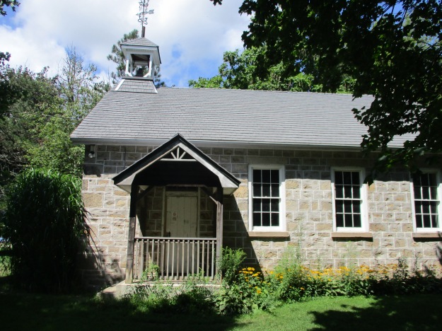
The community of Glenorchy never had a large population and had all but vanished until the city of Oakville started to expand into the area.  It won’t be long before the community will have lost all of its historical charms among new townhouses and subdivisions.  The few original houses and a school stood along the fourth line near Burnhamthorpe Road.

Glenorchy Schoolhouse

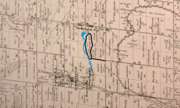
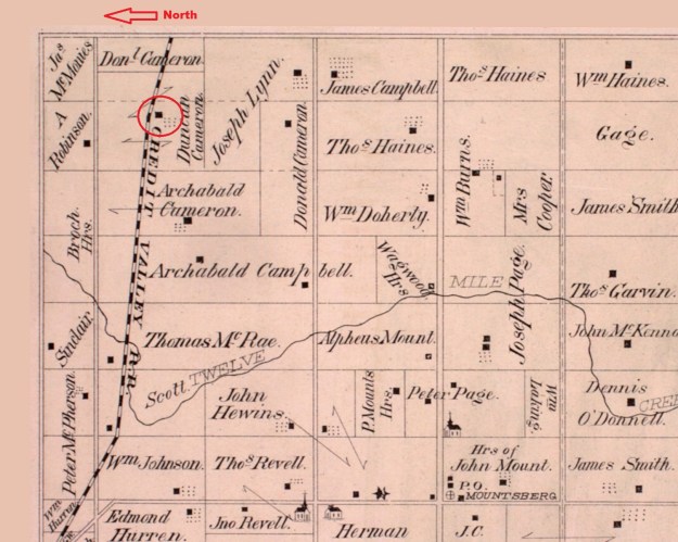
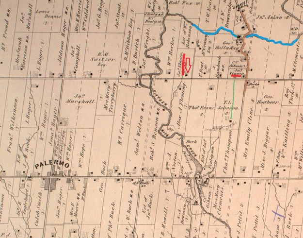
The 1877 county atlas below shows the east branch of Sixteen Mile Creek in blue as it flows under the fourth line which is marked in brown.  Glenorchy is not marked on the map, perhaps because it didn’t have a post office.  The name is likely of Scottish origin and means valley of tumbling waters.  Sixteen Mile Creek and the picturesque valley it flows through could easily give rise to a name like that.

Glenorchy (2)

This picture shows the fourth line with the bridge in the foreground.  A set of stairs leads down the side of the hill to the school which is located in the ravine.  The county atlas above shows the school to the west of the road which means that the earlier road and bridge alignment likely took a more direct route to the bottom and may be still visible behind the stairs at the time of this picture.  This photo was supplied by Neil Omstead.

Glenorchy Schoolhouse

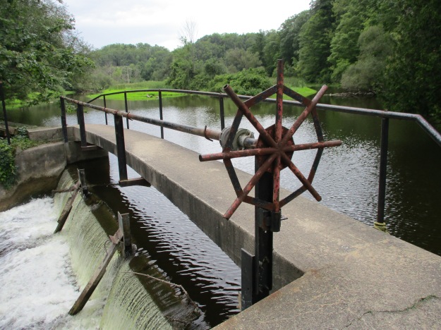
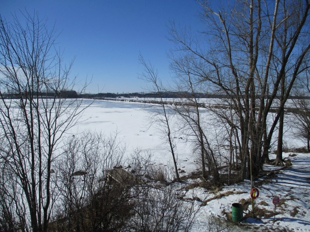
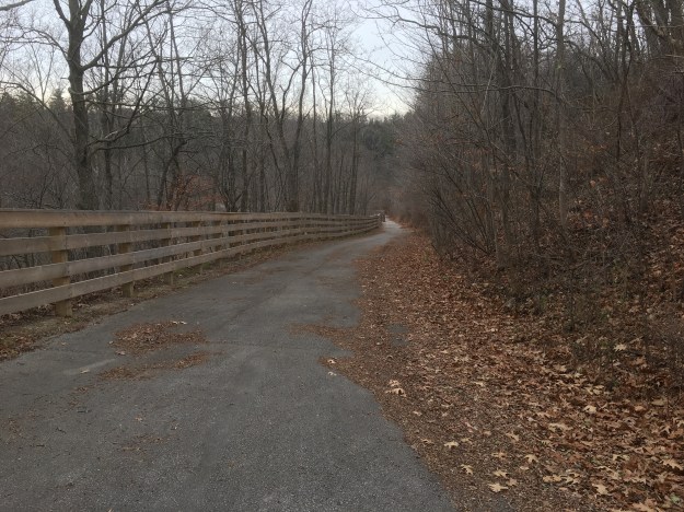
We parked on the Fourth Line south of Lower Base Line near the entrance to Glenorchy Conservation Area.  Glenorchy Conservation Area protects 400 hectares of environmentally sensitive land containing both the Sixteen Mile Creek Valley and Trafalgar Moraine.  The trail follows the old road south and into the ravine.

IMG_1507

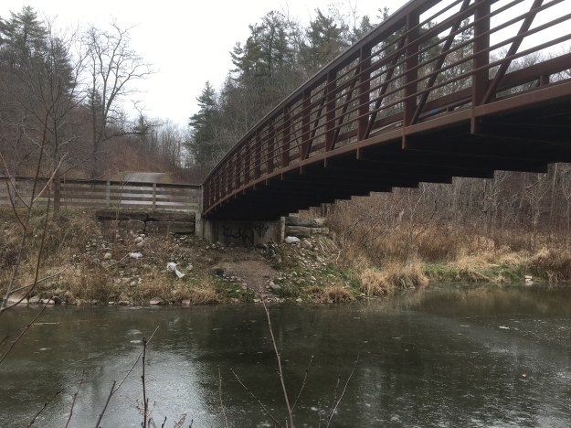
The fourth line makes a steep descent to the creek and on this day the ice was just forming in the water.

IMG_1510

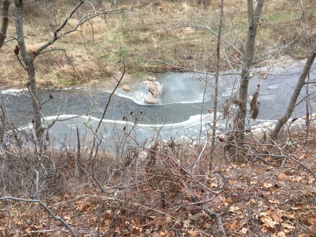
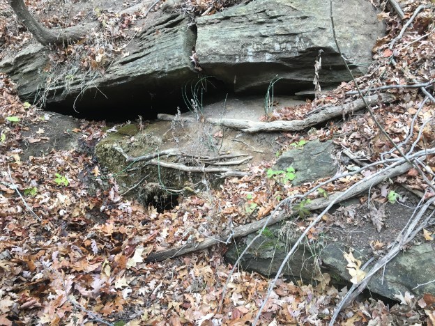
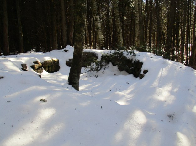
As you follow the fourth line south down the side of the ravine you see the back of the remaining abutment from the former bridge.

IMG_1554

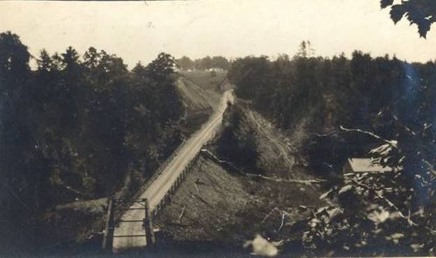
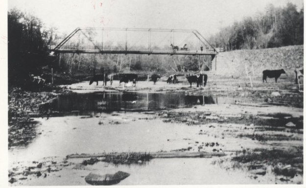
The fourth line bridge over Sixteen Mile Creek is shown in the county atlas of 1877.  The exact location of this bridge has been hidden by time.  In 1898 Dr Ansun Buck of Palermo, a nearby ghost town, designed a new bridge over the creek.  It was built with the north abutment made of cut stone.  The picture below shows the bridge around 1900 and was taken from close to the location of the public school which was built in the floodplain of the creek.

Glenorchy Bridge 1900

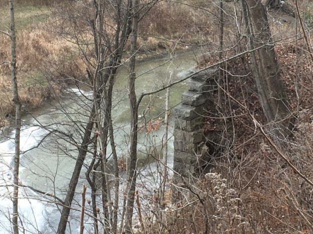
Only the north abutment remains today.  The south approach to the bridge can still be identified by a pathway that has a ridge of earth piled on each side from the levelling of the road.  The north abutment has a major crack in it where the soil has washed away from behind the cut stones and they are slowly shifting.  There is a possibility that this abutment may partially collapse.

IMG_1590

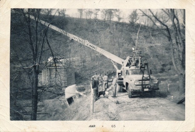
The bridge stood until 1964 when it collapsed.  There was construction in the area and traffic was being diverted onto the fourth line.  A fully loaded potato truck followed the detour onto the bridge but it collapsed under the weight.  The picture below from the Halton Archives shows the truck in the ravine and the crane that was brought in to retrieve it.  The picture is dated March 1965 however that is the date it was printed and not the date it was taken.  In those days, you didn’t get to upload your pictures from the side of the river, you had to wait until the whole roll of film was finished and take it in for development.

glenorchy truck

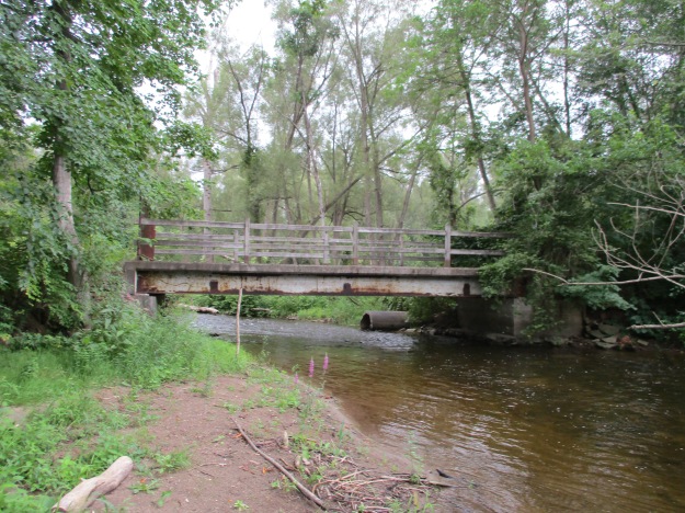
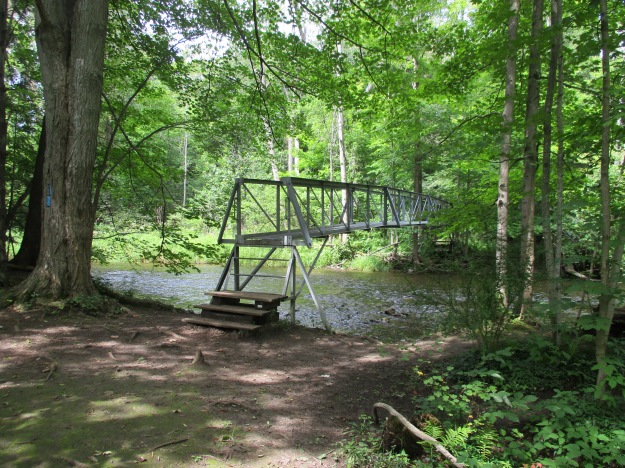
A new bridge was built over the creek in the 1980’s and online sources say it was built on the same abutment as the earlier bridge.  Having visited the site it seems likely that it was built a hundred metres downstream where today’s footbridge crosses.  This bridge was closed in 2001 on a permanent basis.  The steep slope of the northern approach combined with a hairpin turn onto the bridge meant that it was closed for the winter every year anyway.  The road was closed to vehicle traffic but left open for pedestrians and cyclists.  Looking below the new footbridge you can see the larger cut stone abutment for the 1980’s bridge.

IMG_1571

Looking from the south toward the bridge you can see the sharp turn in the road and the steep incline as the road makes its way toward Lower Base Line.  It is easy to see why a fully loaded truck was out of place coming down the steep hill onto the hairpin turn that leads onto the bridge.

IMG_1595

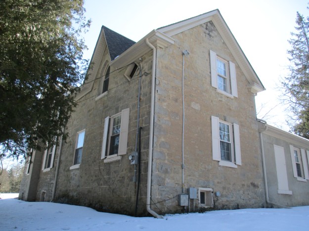
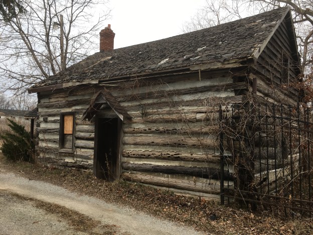
In 1835 George Ludlow and his wife Francis moved to Trafalgar and built this log cabin which stands at the end of Burnhamthorpe Road in Glenorchy.  Francis gave birth to their six daughters in this three-room cabin.  Similar to the first house on the Stong property (now Black Creek Pioneer Village) this house has two bedrooms and a living room where the cooking, weaving and dining would have been done.  The end of the house with the chimney had this family room in it.  The bedrooms are on the end of the house with no window.  The cabin is known as the Ludlow/Slacer cabin because of Martha, the second oldest daughter, who lived here after she married John Slacer.  The cabin is marked with a red arrow on the county atlas above.

IMG_1496

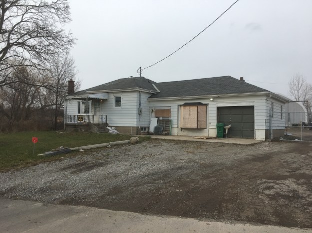
In 1991 there was a sign welcoming people into Glenochy.  The population was 18 at that time.  This house is near the corner of the Fourth Line and Burnhamthorpe Road.  It is one of several that appear to be uninhabited although this one has a light on over the front porch, not exactly common among abandoned places.  There is very little information on historic houses in Glenorchy, unlike nearby Palermo but this house stands on property that also belonged to John Slacer in 1877.

IMG_1604

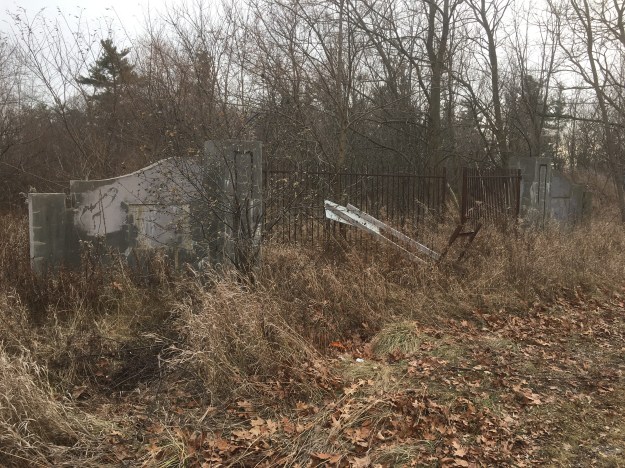
Kings Christian College is located at the corner of the old Fourth Line and Burnhamthorpe where it replaces a couple of historic homes.  This set of gates stands on the south side of Burnhamthorpe Road but a quick investigation shows that whatever they originally announced, remains here no more.  Perhaps they once led to the farmhouse of T.L. Johnson and I’ve marked a potential laneway in green on the map above.

IMG_1599

Glenorchy may have had only 18 people in 1991 but since then it has a brand new subdivision and the town of Oakville is approaching quickly.  The Glenorchy Conservation is yet to be explored and so a future visit is in order.

Google Maps Link: Glenorchy

Like us at http://www.facebook.com/hikingthegta

Follow us at http://www.hikingthegta.com


The Devil’s Cave

Saturday, November 25, 2017

On December 7th, 1837 William Lyon Mackenzie’s rebellion in Upper Canada was crushed and he was forced to flee to the United States to avoid arrest and trial for treason.  The story goes that he hid for the night in a cave north of Oakville before making his way to the border.   Locally the cave has become known as the Devil’s Cave.  An artesian spring in the back of the cave created a small pool which local school children came to call the Devil’s Pool.

The picture below is from the Oakville Archives and is believed to have been taken around 1915 on a school trip to the cave.  Where Bronte Road meets the present QEW was a community known as Merton.  The Merton school was known as SS #15 and was a log building until 1857 when a brick one was constructed.  It was demolished to make way for the QEW and the few remaining students were taken to Palermo starting in 1958.  We knew the cave had collapsed and couldn’t be entered but set out to locate it and see what remained.

Merton

As soon as we started moving through the grass on leaves we disturbed a number of small white moths.  Winter moths emerge from the ground between late November and the end of the year.  They are an invasive species of which only the male can fly.  The female crawls to the base of a tree where she attracts the male with her pheromones and then lays about 150 eggs in the bark.  In the spring the caterpillars hatch and begin to devour the leaves of maples, oaks and apple trees.  In the middle of the summer, the caterpillars go underground to pupate and emerge as moths in the fall.  They can kill a tree by removing the leaves for three years in a row.

IMG_1099

There are several distinct roadways and man-made berms as you descend the side of the ravine.

IMG_1101

This section of the ravine revealed a pioneer artifact in the form of an old saw.

Saw

There is a fisherman’s trail along the creek but you will need good footwear or you can count on wet feet and you make your way through several sections of wetlands and marsh.  The sides of the ravine have open seepage as water flows along the surface of the hillside.  There were still a couple of late-season salmon in the river although the run is basically over.

IMG_1102

There is a point where you will not be able to continue at river level due to the shale cliff that has been eroded into the embankment.

IMG_1114

Forced upward you will find the limestone to be full of fossils.  The limestone is full of holes which is evidence of karst activity, typical of the formation of caves.

IMG_1119

About 3/4 of the way up the hillside is the remains of the entrance to the Devil’s Cave.  It has collapsed some time ago and can no longer be entered.  Water flows out of the bottom of the old entrance, perhaps a legacy of the old pool inside the cave.

IMG_1127

Probing with sticks and flashlights showed that the cave extends farther than can be seen with the available light.

IMG_1133

At this point you will be forced to retrace your steps.

Like us at http://www.facebook.com/hikingthegta

Follow us at http://www.hikingthegta.com

River and Ruin Side Trail

Saturday, August 19, 2017

The River and Ruin Side Trail explores the property that formerly belonged to James Cleaver.  James built the mill in Lowville and a stone house for his family.  The mill still exists as a private residence but the house has been ruined for many years.  There are four or five official parking places along the side of Britannia Road at the intersection with the Blind Line.  The Bruce Trail follows the right of way for the Blind Line and it descends to the level of Twelve Mile Creek.  Just before you reach the creek you will come to the River and Ruins Side Trail which is marked with blue blazes on the trees.  It is a 2.5 km trail that wanders through some heavy patches of Wild Parsnip, a poisonous plant.

Lowville RnR

James Cleaver was born in Pennsylvania on January 30, 1800, and was 5 when his family moved to Upper Canada.  In 1813 James went with the family horses when they were conscripted for use in the War of 1812.  It is said that James and his team were at the Battle of Stoney Creek.  It was around this time that he took an interest in becoming a Public Land Surveyor and started to attend school to qualify for this occupation.  He was 20 years old and teaching in the Lowville one room school house when he completed his studies.  The County Atlas pictured above shows the land as belonging to Cleaver PLS or Public Land Surveyor.  It was uncommon for a land owner’s occupation to appear on the map and perhaps James put this here himself.

The house was added onto at least once and it appears that there was certainly a need for it.  James married Angeline DeMond on November 3, 1827, and they had 7 children before she died in 1841.  James took Jane Watson as a second wife and had 11 more children with her.  Cleaver died March 30, 1890, leaving his land holdings to his sons. Instructions were given for the leasing of the Cleaver Grist Mill in Lowville with the money being divided among the seven living daughters.

IMG_0943

The stone that James used to build his house was taken from the property.  Larger pieces of dolomite were used for the front walls as an expression of the status and importance of the occupants.  The rear and side walls were made of smaller pieces of limestone.  The front walls had dolomite window sills and lintels while the back of the house had rough-hewn logs for the window framing.  The cover photo shows the front side of the house and the second story can be seen in the form of window sills along the top of the wall. The walls are about 20 inches thick with wood strips set into the inside of them to allow for the application of the inner wall coverings.  These can be seen in the picture above which looks at the front wall from the inside.  The door easily accommodated James’ six-foot two height.  The story circulates on the internet that the house burned down in the 1920’s but there appears to be no physical evidence of this. All of the wood framings are free of char marks that would indicate a fire.  The limestone pieces that have fallen down contain many interesting fossils including the crinoids in the sample pictured below.

IMG_0934

Following the trail will eventually bring you to Twelve Mile Creek, otherwise known as Bronte Creek near an old concrete and steel beam bridge.  The opposite side of the creek is clearly marked as no trespassing and the bridge claims to be under video surveillance. Both ends of the bridge are closed with steel gates.  Notice the large concrete culvert in the creek, just behind the bridge.

IMG_0976

The Cleaver Mill Pond has been drained but a concrete dam still remains in place, close to Guelph Line in Lowville.  The approach along the river follows a well-used trail that likely represents the old Cleaver laneway.  Once you cross over the dam you will find that you are on the wrong side of a no trespassing sign that blocks access from the road.

IMG_0985

The river portion of the River and Ruin Side Trail splits at one point to provide a winter and early spring trail called the High Water Trail that keeps you out of the mud and water along the side of the creek.  The Low Water Trail is more scenic and is the one to follow in the summer and autumn months.  When you get back to the point where the side trail connects with the main Bruce Trail you will find an elevated bridge that carries the Bruce Trail across Bronte Creek.

IMG_1009

There are several historic buildings in Lowville including the old grist mill, churches, and the pioneer cemetery.  Lowville Park stands just beside the old school house built in 1889 and pictured below.  This is a replacement for the school that Cleaver once taught in.

IMG_1020

The Bruce Trail and its side trails around Lowville make for an interesting outing and are close to several other great hikes including the following:

The Longhouse People Of Crawford Lake

Nassagaweya Canyon

Rattlesnake Point 

Mount Nemo

Kelso’s Kilns

Google Maps Link: Lowville

Like us at http://www.facebook.com/hikingthegtaFollow us at http://www.hikingthegta.com

Follow us at http://www.hikingthegta.com

Mountsberg

Saturday, February 18, 2017

Mountsberg Conservation Area covers 472 hectares of which 202 are covered with a water control reservoir.  Since 1994 the park has featured a Raptor Centre which is home to a collection of 15 birds of prey.  Horses and sheep call the farm home along with bison and elk.  There’s also a play barn for the kids to enjoy and a Maple Syrup festival in the spring. Sixteen kilometres of hiking trails criss-cross the park and allow you to experience the abundant wildlife.  There is a $7.50 fee per car and you have to put it into an envelope so be sure to bring correct change or plan to make a donation.

Archibald (Archabald on the County Atlas below) Cameron moved from Perthshire in Scotland in 1833 and settled on 100 acres of land.  His son, Duncan bought the property adjacent to his and Donald purchased two parcels of land next to these.

cameron-farm

Duncan Cameron purchased the 100 acres to the east of his father’s lot and started his homestead there.  In 1857 he built a stone house and a barn, both of which remain today. The house has an odd window on the second floor which was shaped like a simple diamond.  The county atlas shows how close to the house the Credit Valley Railroad was constructed when the Milton line was extended to Galt in 1879.  The Duncan house remained in the family until James Cameron, Duncan’s son, passed away in 1962.  The farm changed hands a couple of times and was purchased in 1964 by The Halton Region Conservation Authority.  They built the dam in 1966 and the Wildlife Centre in 1974.

img_6381

Near the barn is an observation tower which looks out over the Mountsberg Reservoir. Bronte Creek was dammed and the reservoir has since been stocked with fish.  Bass, Pike, Crappies, and Perch can all be caught in the shallow waters.  The former Credit Valley Railway crosses the reservoir on a berm that previously passed through a farm field.  The lower section of the reservoir has been drained for the winter.

img_6408

On the north side of the tracks, just east of the house are the remains of the family lime kiln.  It was built shortly after the house, likely around 1860, for the use of the family. Limestone was common in the area and settlers would load it into a set kiln like this one. Wood was packed around it and burned for several days until the limestone was broken down.  The limestone was broken into lumps around 2 inches in diameter and layered into the kiln along with the fuel.  It would take about a day to load the kiln and then it burned for three days.  After two days of cooling down, it could be unloaded and the lime separated from the waste.  Lime was used in the making of soap as well as construction materials.

img_6362

The first Earth day took place on April 22, 1970.  Since that time it has grown into an international event that takes place in 193 countries around the world.  In 1990 Earth Day 20 was celebrated and in Mountsberg Park the Plant-A-Tree program contributed the small forest on the north side of the train tracks, across from the Cameron House.  These trees are doing quite well a quarter century later.

img_6375

The Raptor Centre at the park is home to many birds that have been rescued locally and are incapable of survival in the wild.  The Great Horned Owl on the cover photo is one of two in the park.  These owls have a grip ten times as tight as that of a human and talons that can hold with as much as 200 pounds per square inch force.  They are known to take prey that is up to three times their weight and this includes skunks, opossums and even other raptors.

The Gyrfalcon, seen below, lives in arctic and sub-arctic regions and is rarely seen in Southern Ontario.  This is the largest of the falcon species with the females weighing up to two kilograms.  Their diet contains mostly of other birds including ducks, gulls, and geese but they also enjoy lemmings and hare.

img_6305

Rough-legged Hawks are the only hawks in Ontario that have feathers on their legs extending down to their feet.  It weighs about a kilogram, with the female being slightly larger. They are a northern bird and live mainly off of small rodents like voles and lemmings. They can be occasionally be seen in Southern Ontario during the winter.

img_6290

Broad Winged Hawks live in large forests and prefer small rodents for their prey as they only weigh about 500 grams themselves. They are relatively small among the hawk family but congregate in large flocks known as kettles in the fall to migrate south for the winter. A kettle of broad winged hawks can contain up to 1000 birds

img_6284

Takenya is one of two red-tailed hawks at the centre but she sits up and pays attention when you call her name.  One of the trainers suggested that the birds don’t actually know their names but as the picture below shows, she would turn her head and stare right at you when you call her.

img_6265

American Bison, often called Buffalo in error, are kept on the farm.  As we approached they moved across the field but soon returned to stand by the fence.  The largest of the five already had a broken horn and was clearly guarding the smaller ones.  It routinely stood between me and the smallest one so getting a picture was quite difficult.  I wasn’t sure if it was my red coat or the imminent arrival of the ladies with the food buckets that had their attention but after feeding they went for a run around the pen.  They can reach speeds up to 60 kilometres per hour.

img_6231

Mountsberg has extensive hiking trails as well as the dam that are yet to be explored.  This is a park that will require more than one visit.

Our top 15 stories are previewed here.

Google Maps Link: Mountsberg

Like us at http://www.facebook.com/hikingthegta

Follow us at http://www.hikingthegta.com