Monthly Archives: March 2022

Boynton House – Richmond Green

Sunday, March 27, 2022

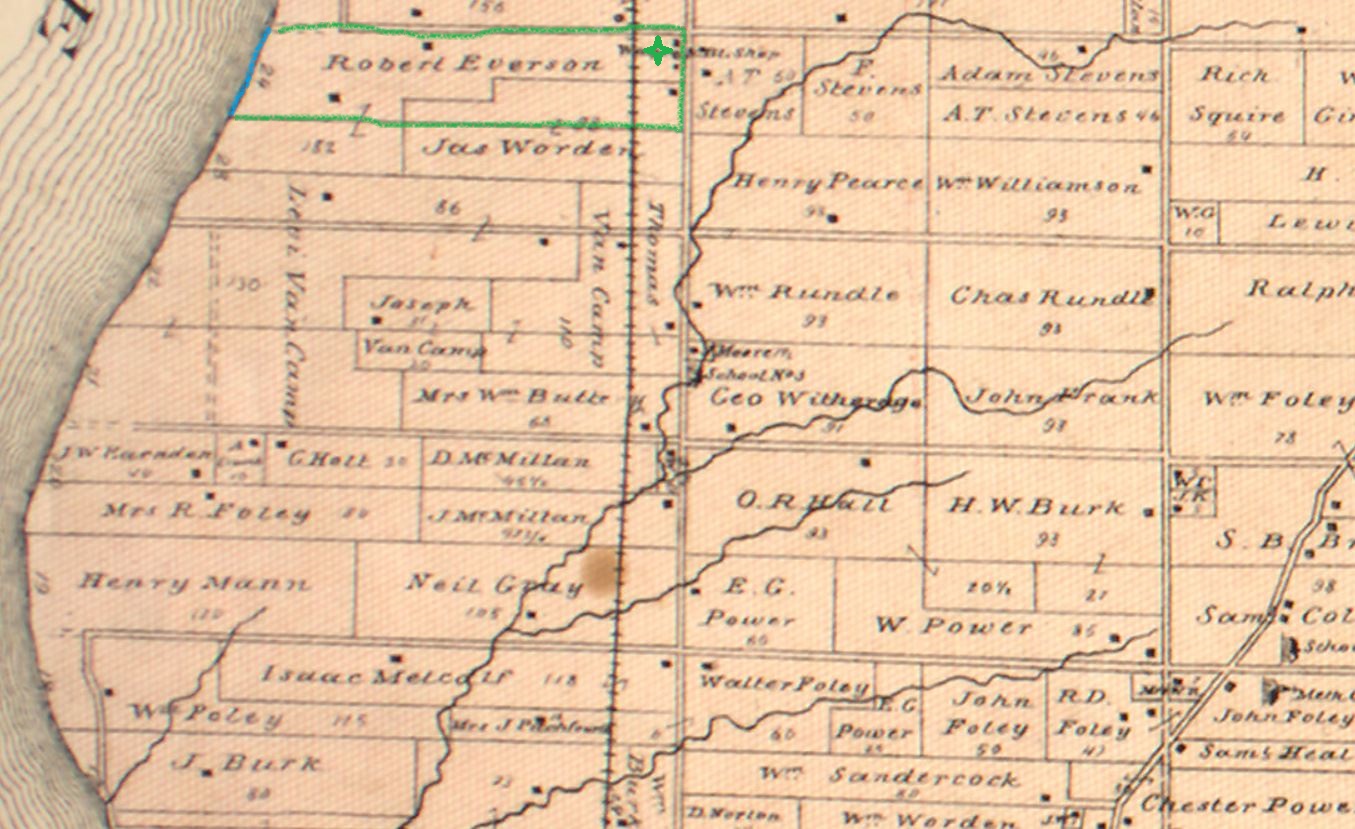
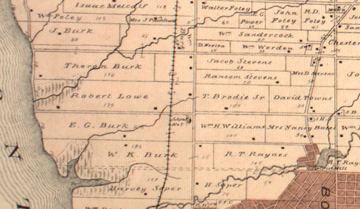
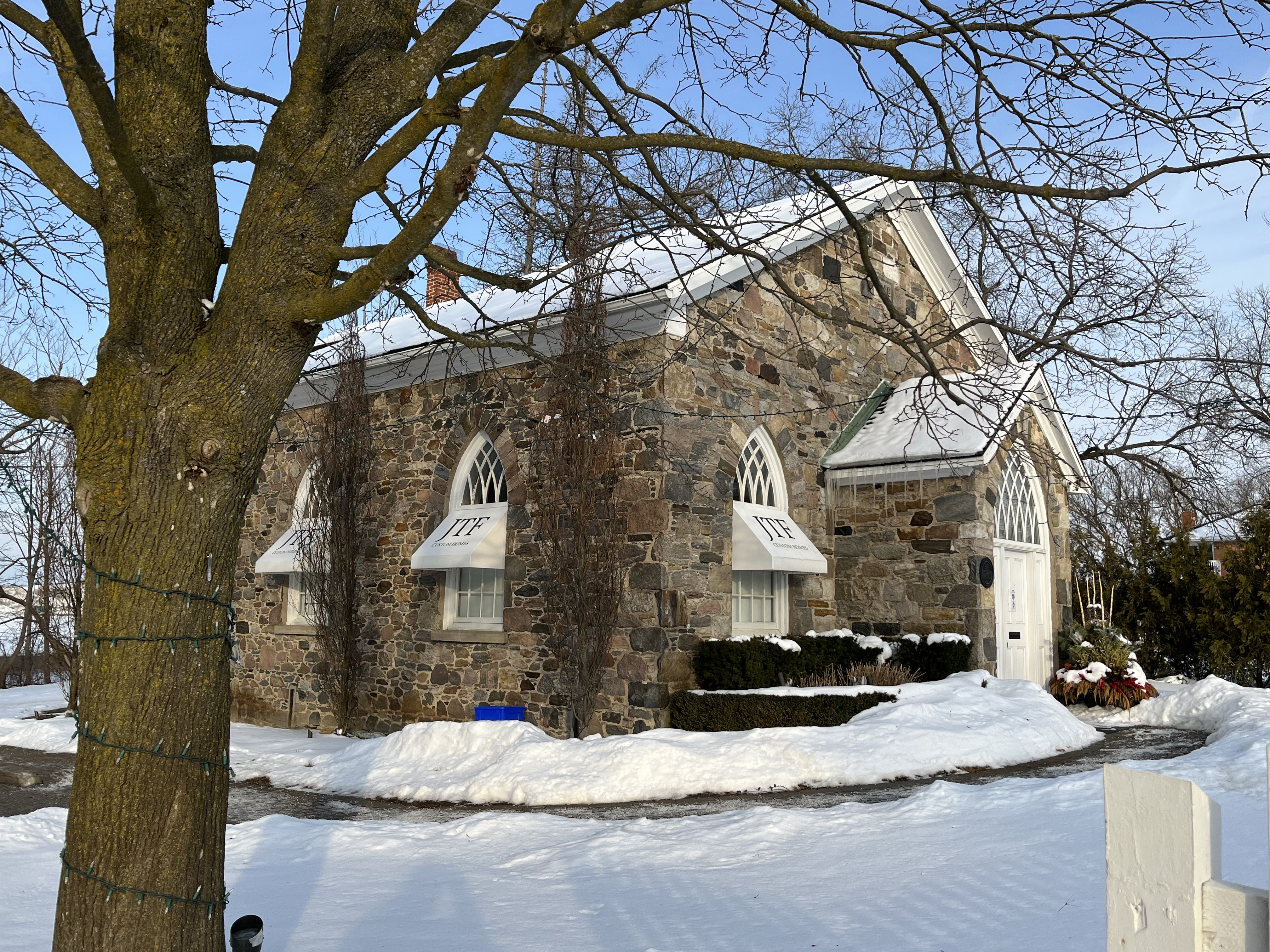
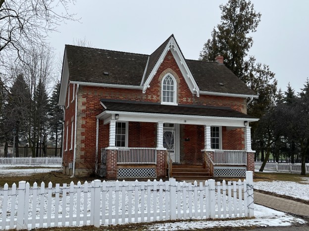
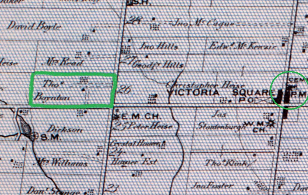
Richmond Green is the largest park in Richmond Hill and is located at the modern intersection of Elgin Mills Road and Leslie Street. When the land was surveyed for a farm lot it was numbered 26 and extended from East York Line (Bayview Avenue) to Leslie and comprised 200 acres of forest. The original land grant was given to Peter Gotfried Phillipson in 1816 but as soon as he had gained ownership he sold it to John Doner. It was sold several times and finally in the 1840’s the east half and the west half were each sold as separate 100 acre lots. Thomas Fenby Boynton bought the east half lot in 1874 and he is shown as the owner in the section of the 1877 County Altas map shown below.

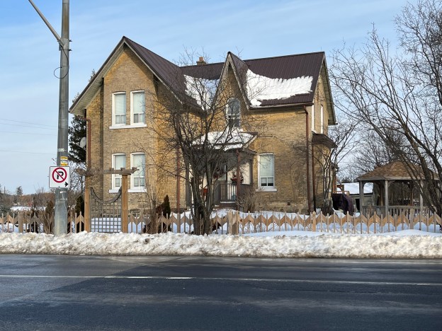
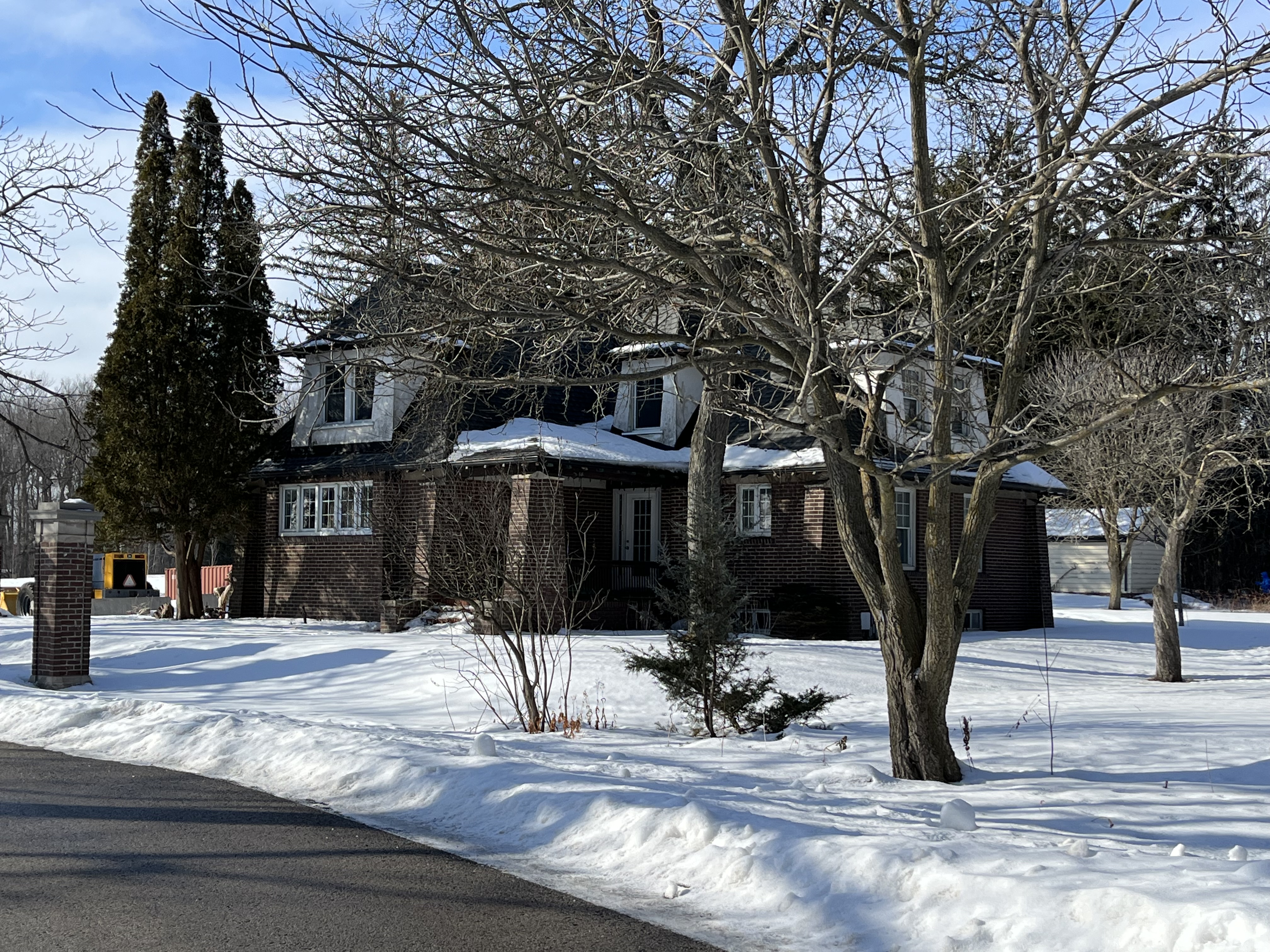
The original log home on the property was replaced the following year with the present brick home. It was a typical three-bay, storey and a half house in red brick. The trim work was done in buff brick giving the home a distinctive look. In the early 1900s Thomas Edward Boynton added the front porch in the Edwardian Classical style that was popular after 1910.

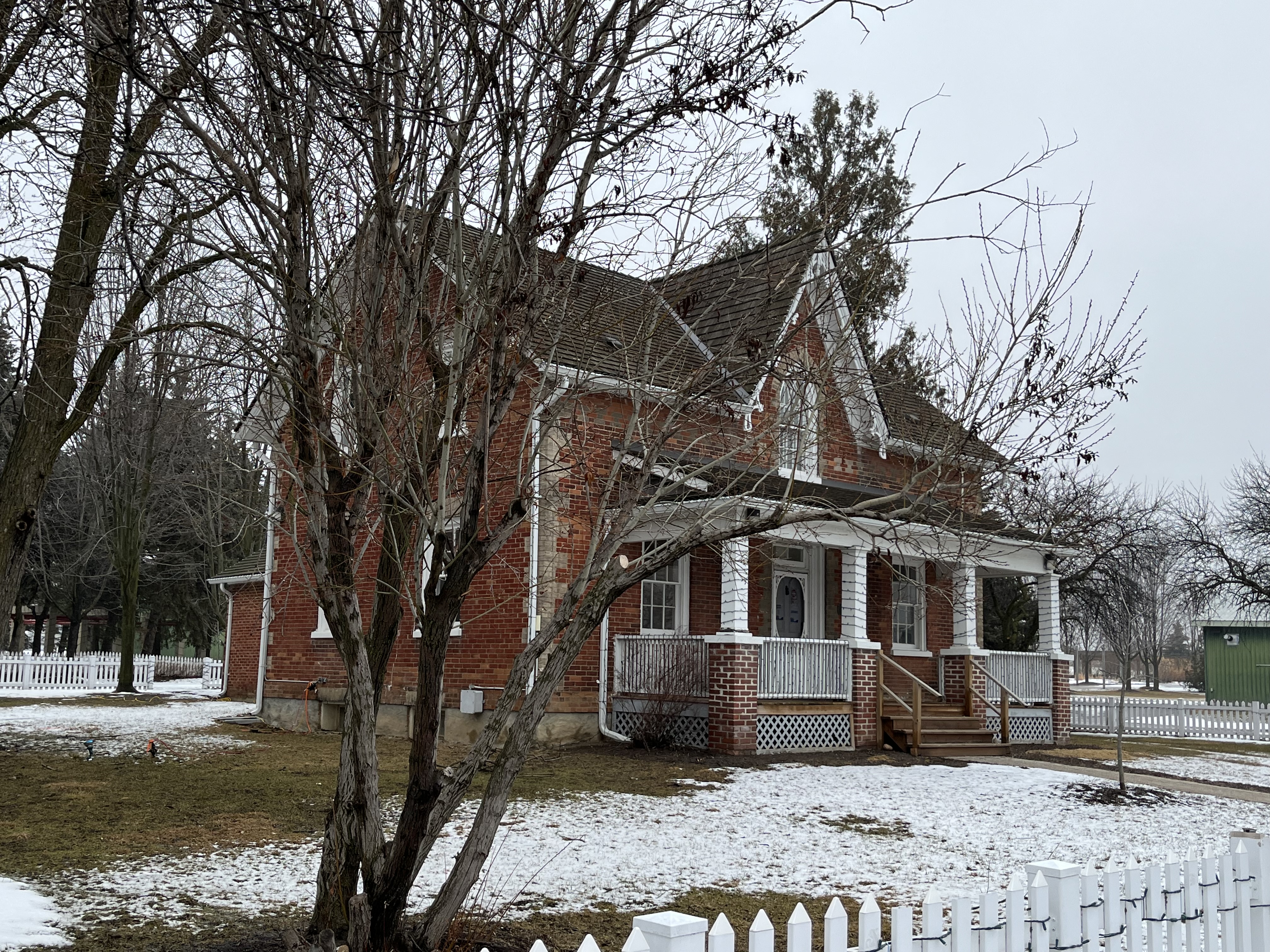
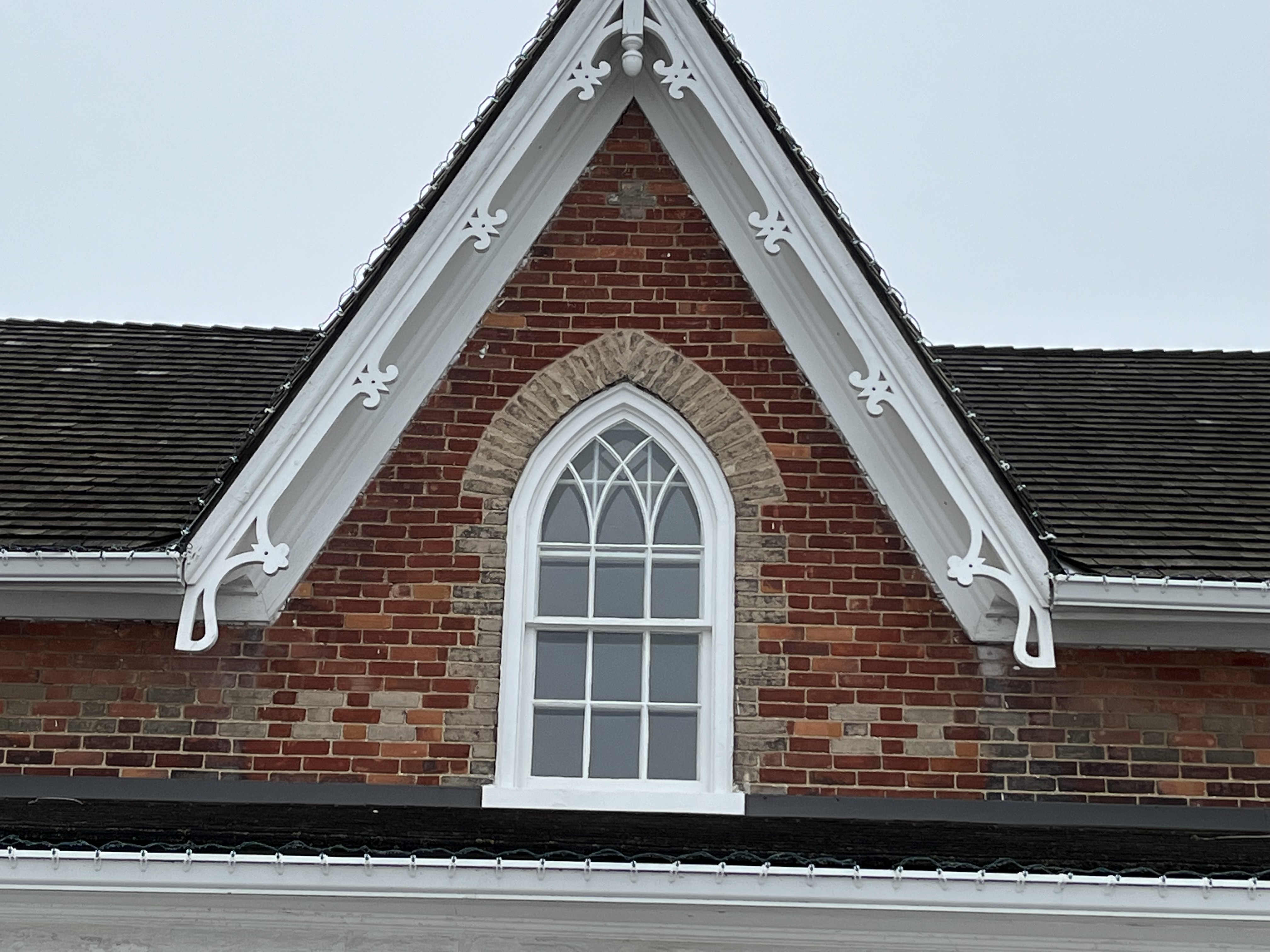
A small amount of gingerbread adorns the front gable over the gothic window which is accented by the use of buff coloured bricks. The window has fine pattern of glazing which creates additional gothic arches in the glass.

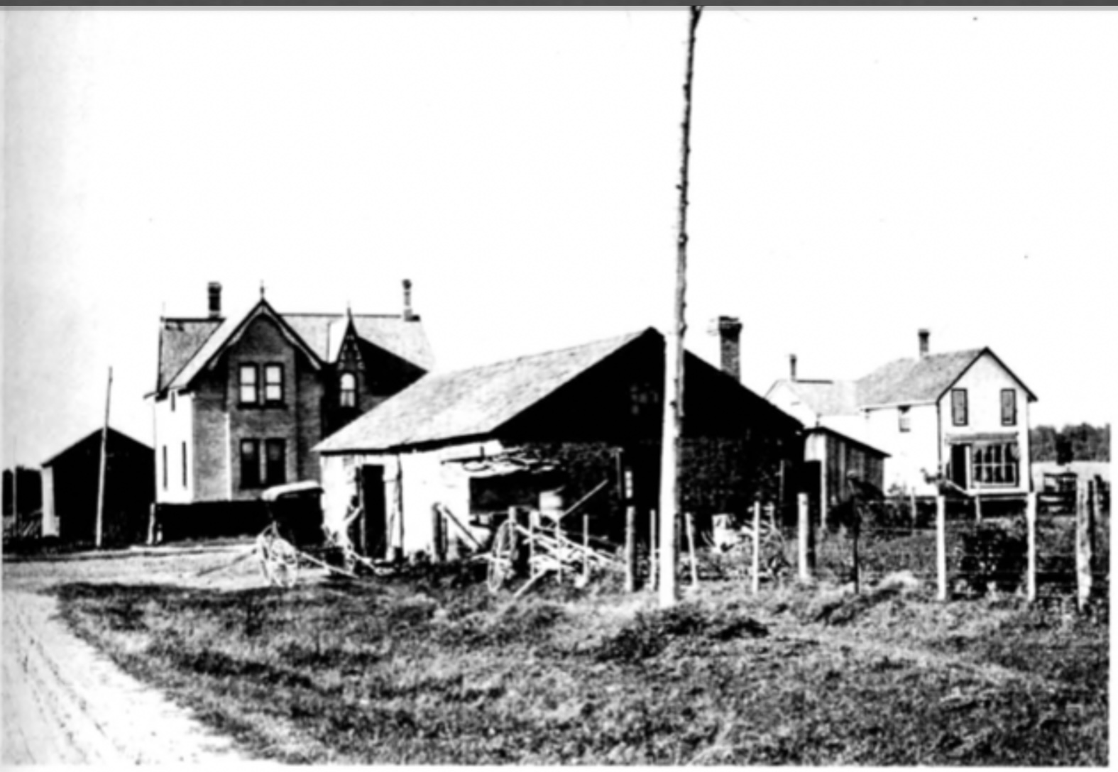
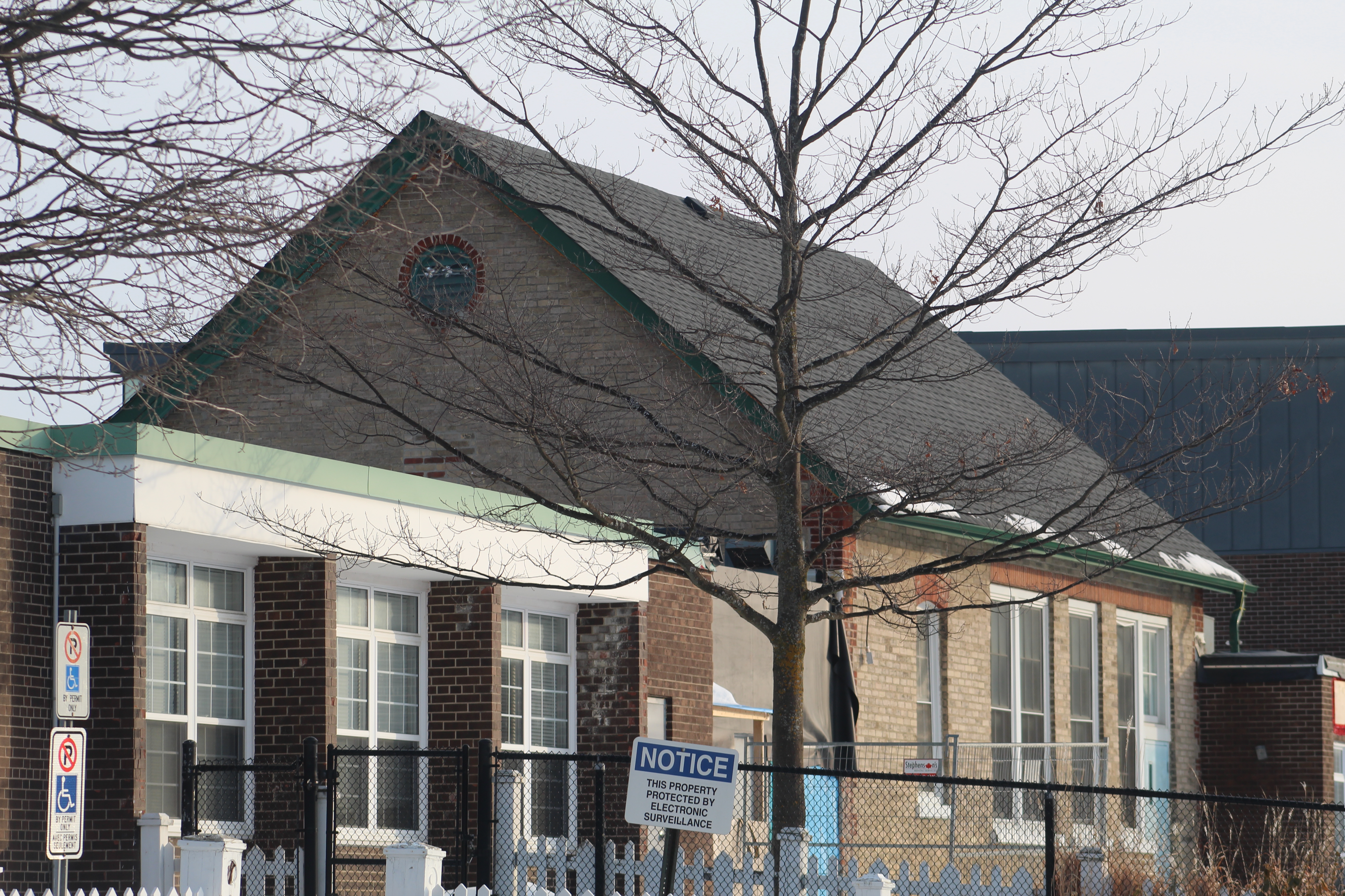
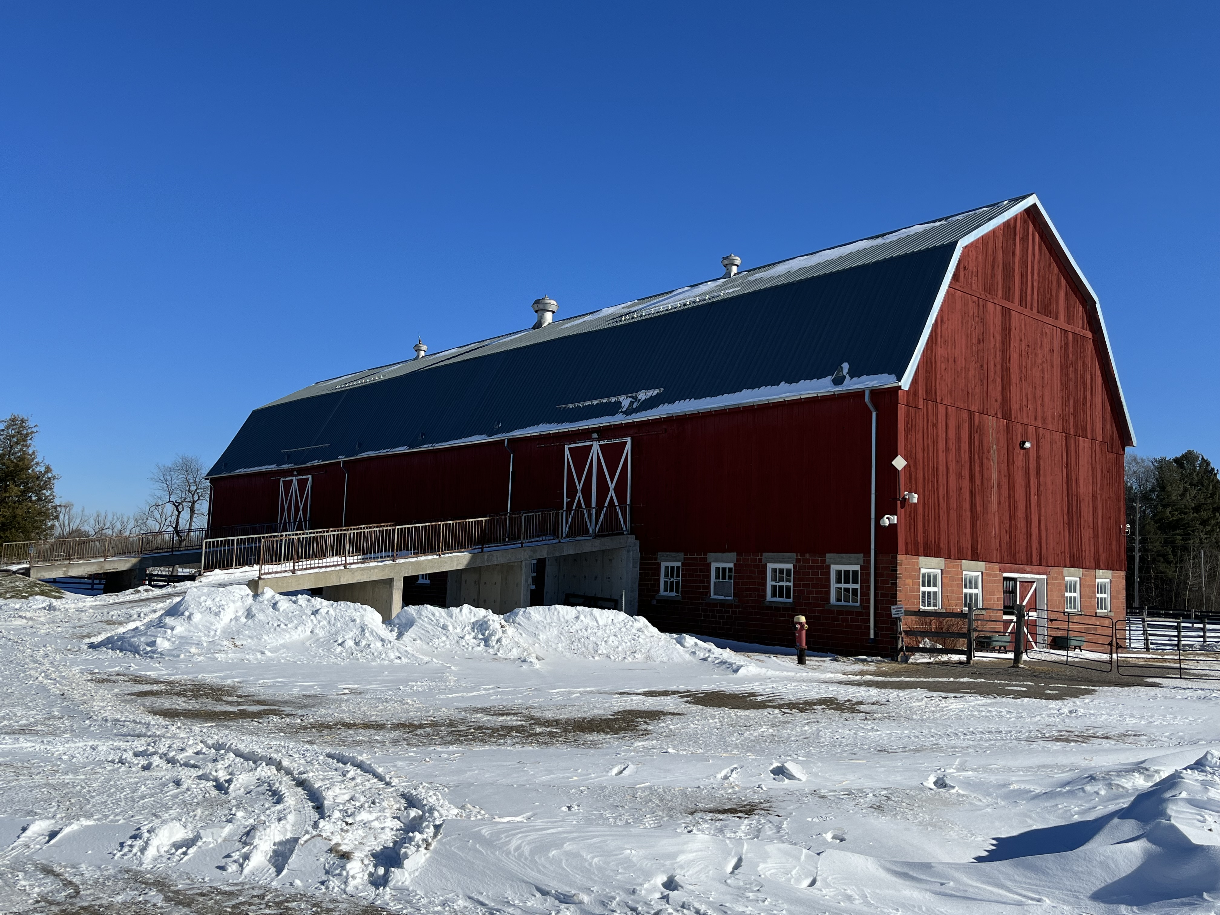
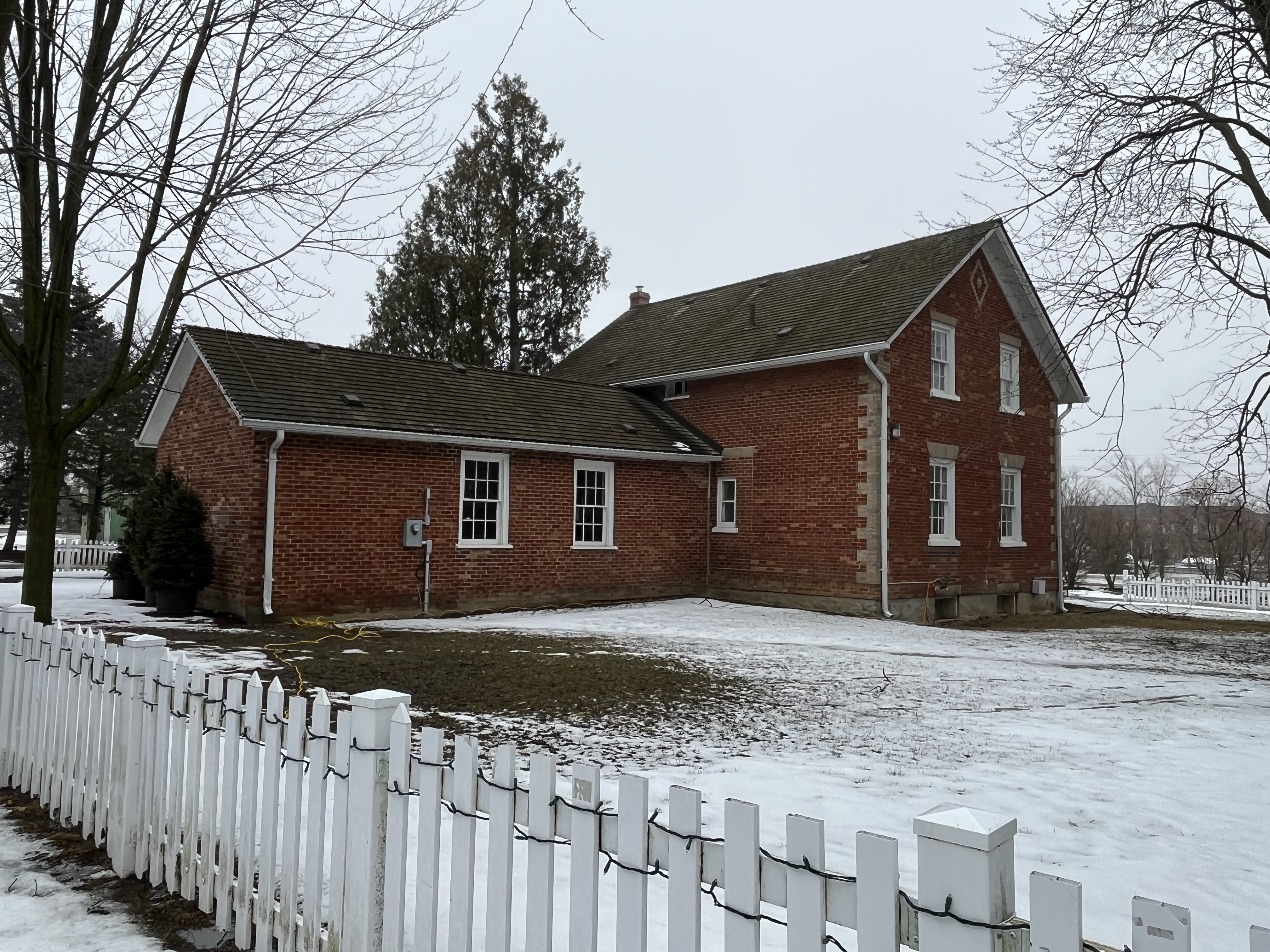
The Town of Richmond Hill bought the Boynton farm in 1974 to create a new park and fairgrounds. Initially, the area around the barn was used for a recycling depot for the town. The Spring Fair had been a tradition in Richmond Hill since 1849 and in 1985 the new park was ready to welcome its first Spring Fair. However, as Richmond Hill expanded over the agricultural lands around it the Spring Fair became obsolete and the last one was held in 1996. In 1985 Richmond Green also became home to the first indoor soccer fields in Canada. The picture below shows how the house has been expanded on the back where the patterned brickwork wasn’t continued.

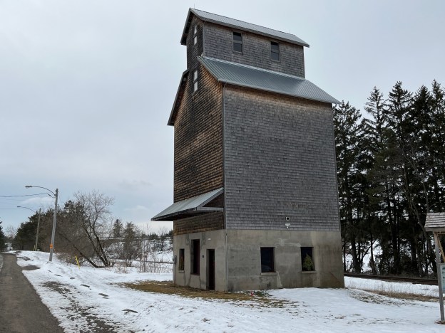
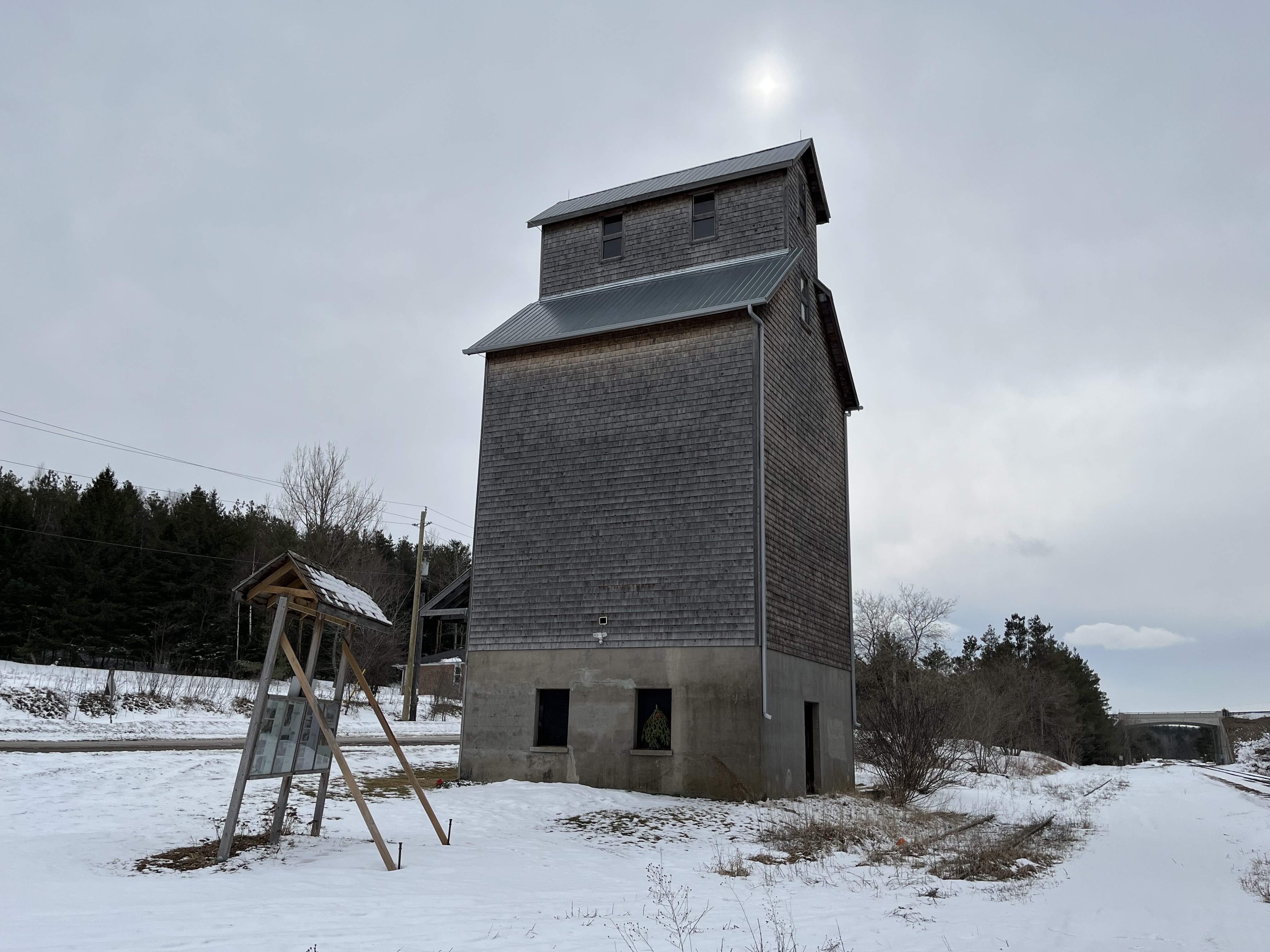
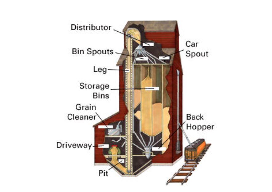
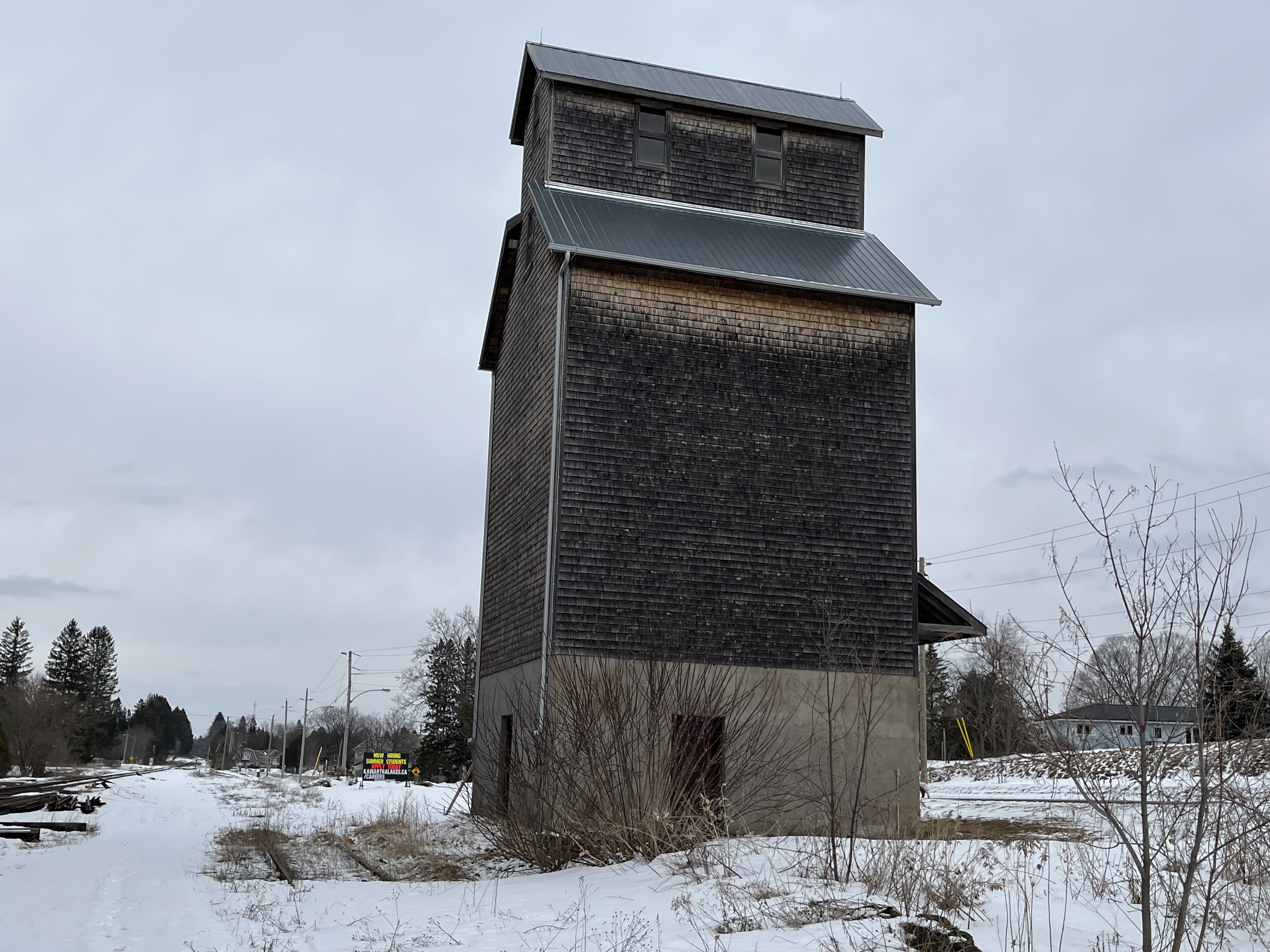
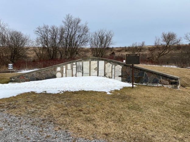
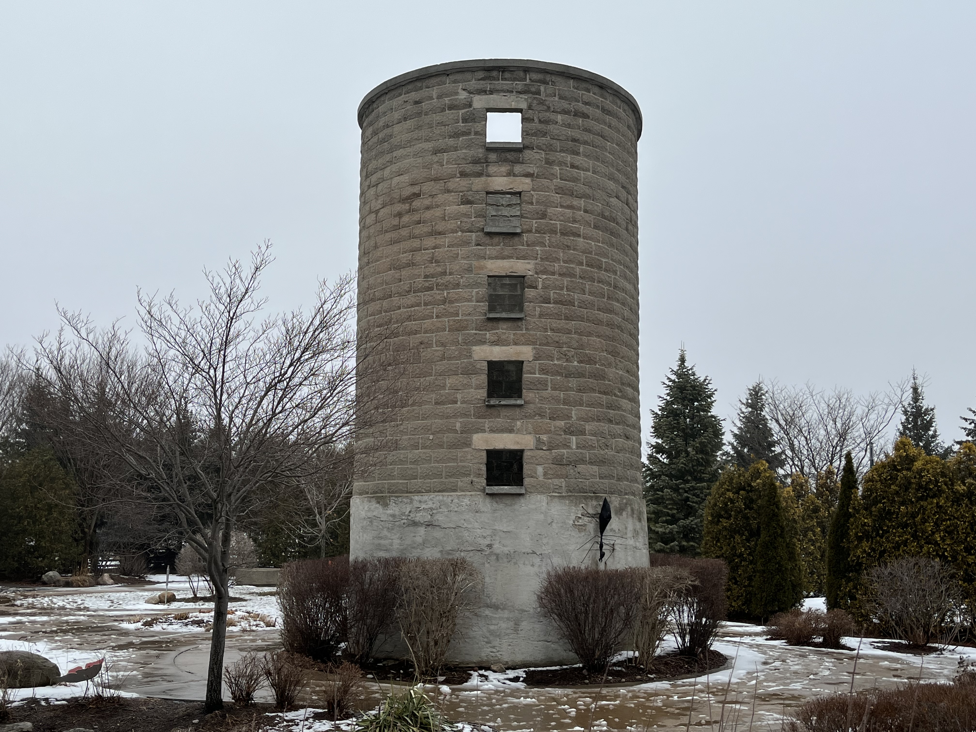
The barn is long gone but the silo remains. The use of concrete blocks identifies it as having been built in the early 20th century when it would have been used to store feed for the farm animals. There is still a barn and paddock on site as well as a host of other features including an in-line skate trail that is turned into a skating trail in the winter. There are also soccer fields, ball diamonds, bocce courts, outdoor basketball courts and two ice rinks as well as trails throughout the grounds.

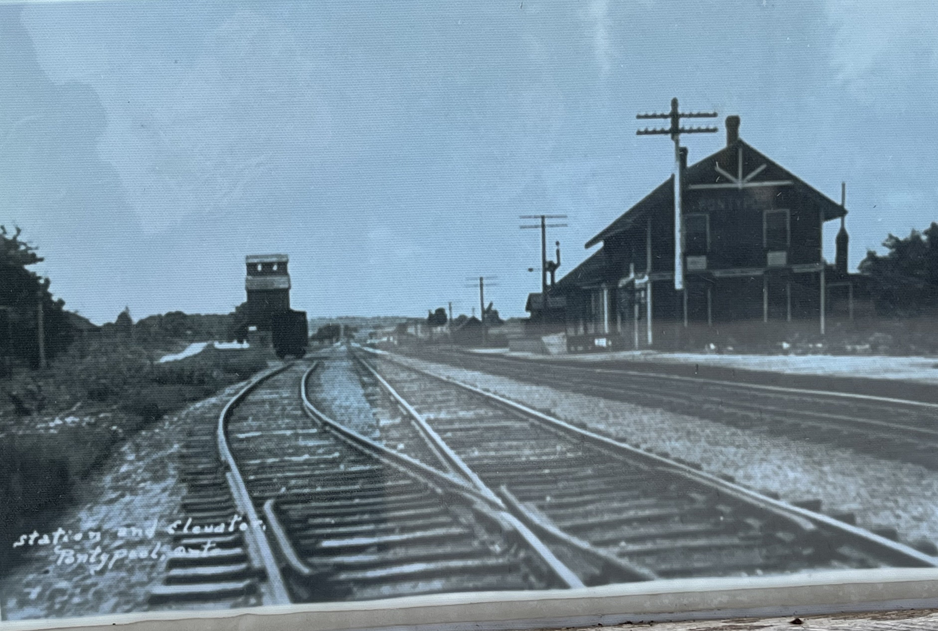
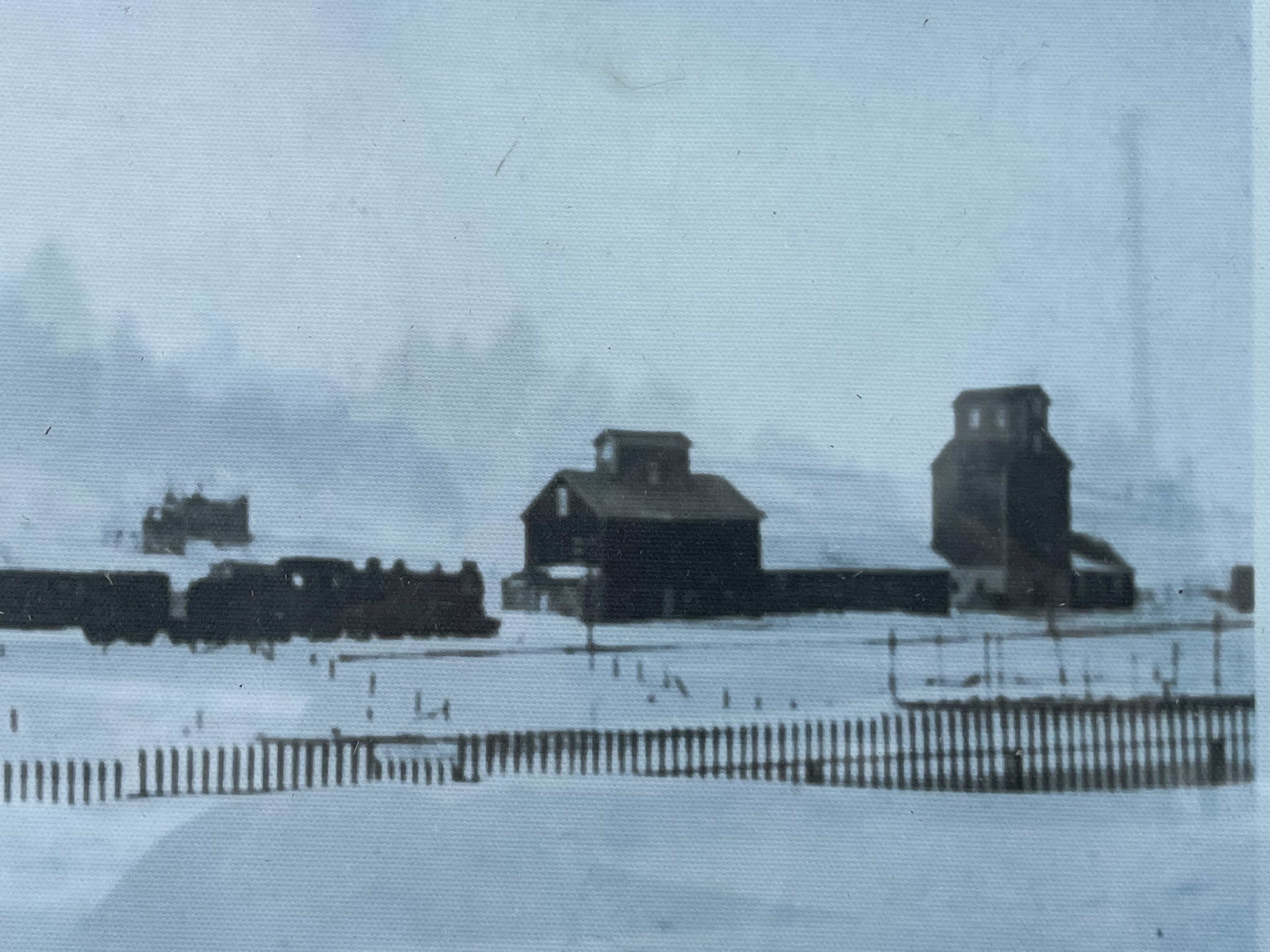
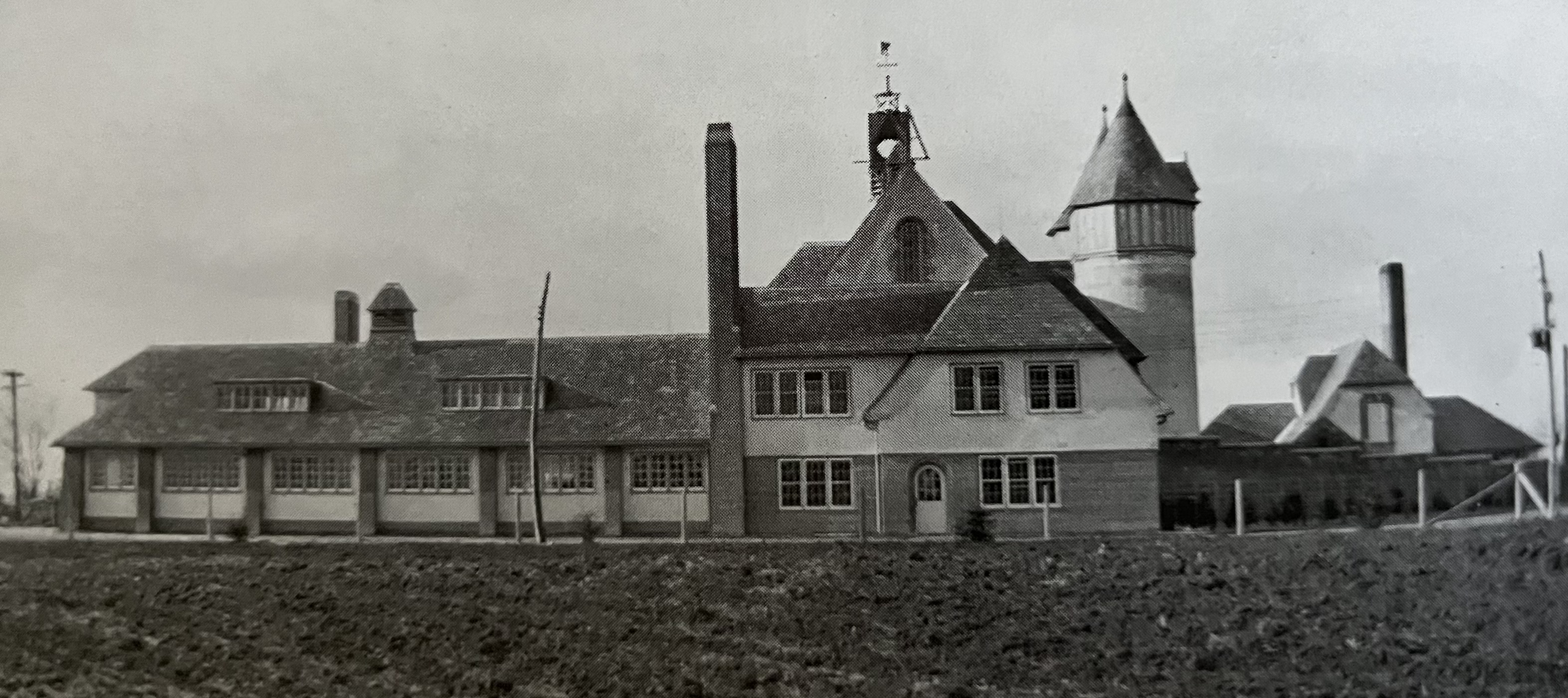
The Canadian Northern Railway (CNO) arrived in Richmond Hill in 1906 and built a station, freight shed and water tower. The line linked Toronto with Northern Ontario and was one of the railway lines amalgamated to form the Canadian National Railway (CNR) in 1918. The standard design for CNO stations involved having a waiting room on one end and a freight area on the other. The station master had the section in the middle. The post card below shows the station in 1906 and was taken from The Richmond Hill Archives.

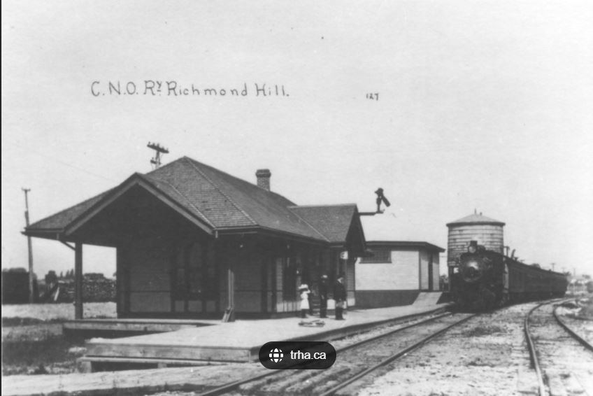
As diesel replaced steam in the 1950s, so personal automobiles replaced trains as a means of transportation. The water tower became obsolete and was removed and by 1968 there wasn’t enough passenger traffic to keep the station open.

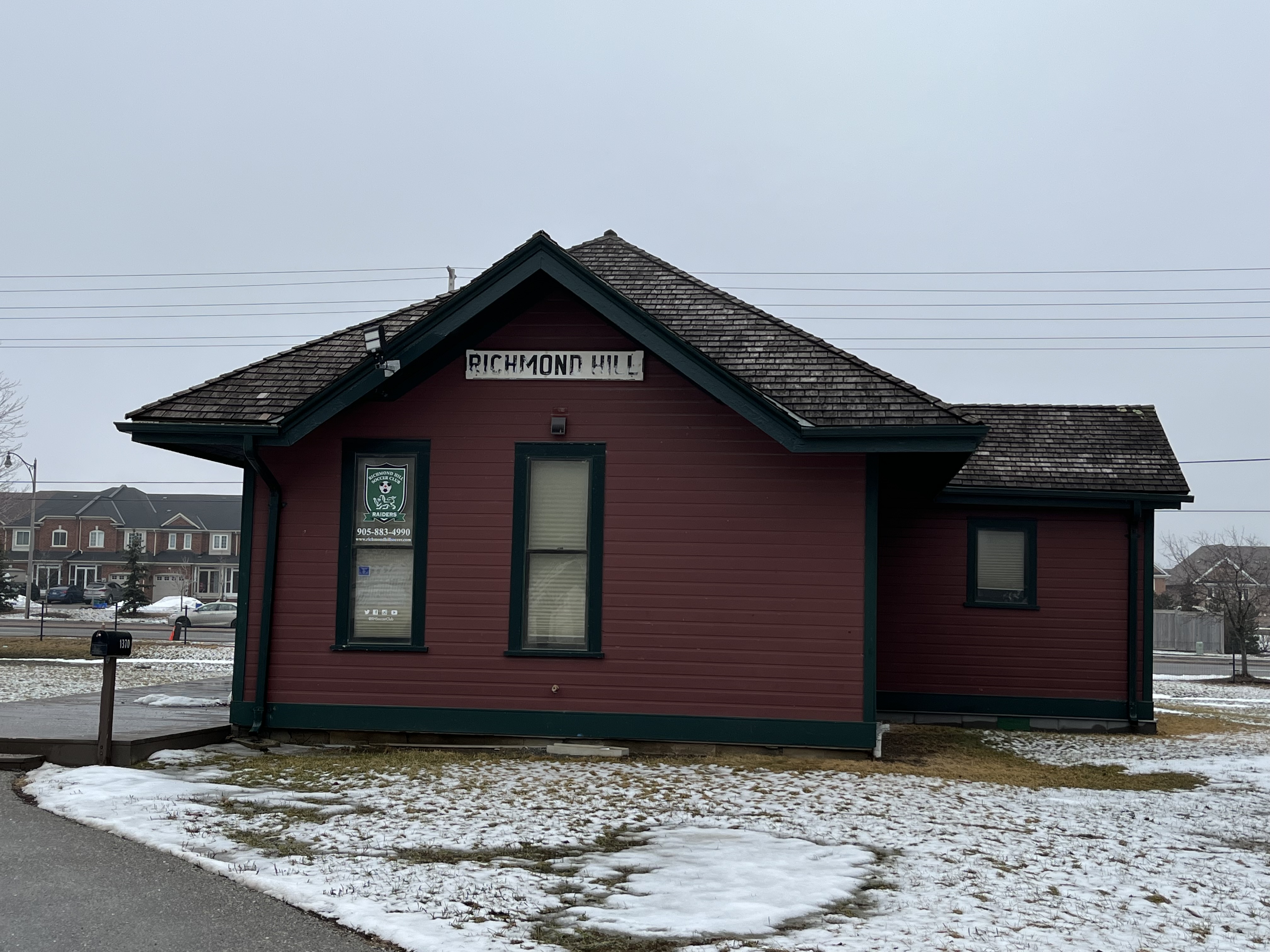
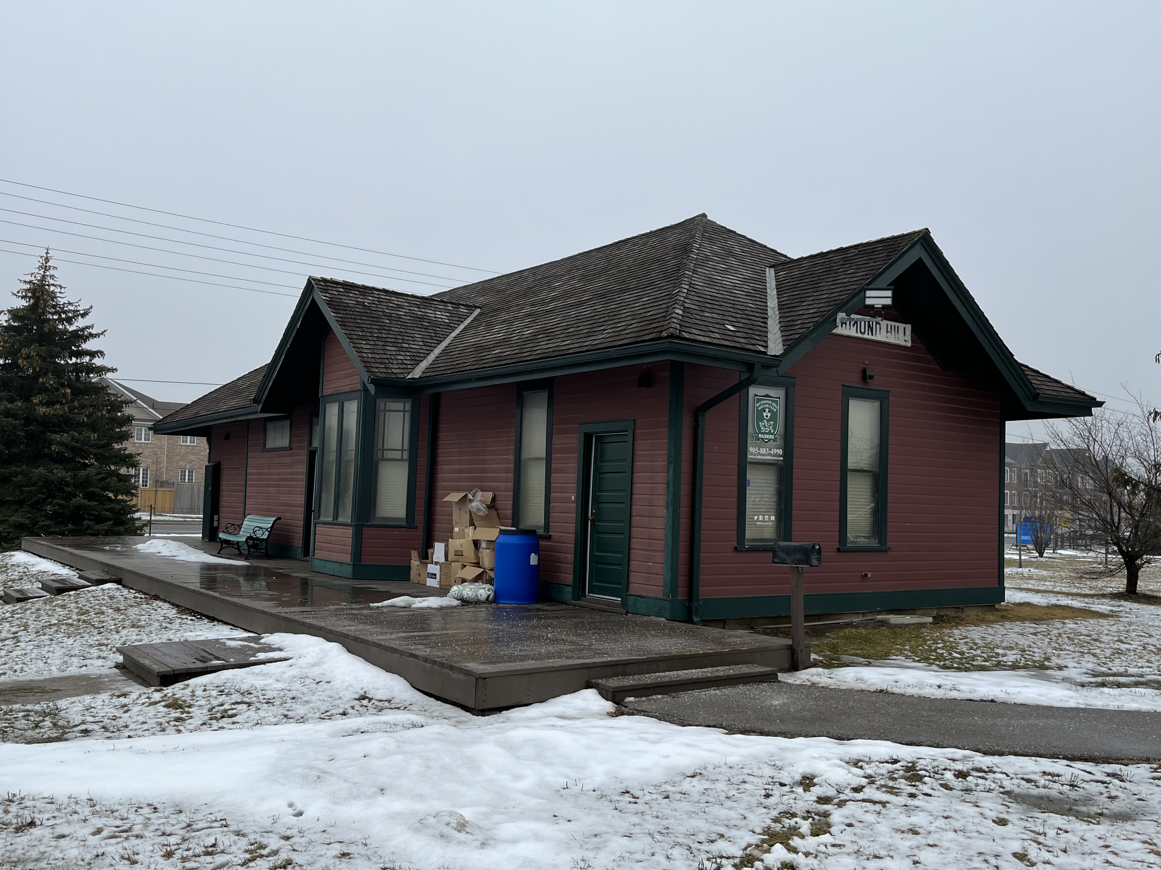
In 1979 the station was moved to the soccer fields at Richmond Green and is now used as a clubhouse by The Richmond Hill Soccer Club.

The park hosts several seasonal events including Canada Day, a ribfest and antique shows making it a place worth visiting several times.

Related Stories: Victoria Square

Google Maps Link: Richmond Green

Like us at http://www.facebook.com/hikingthegta

Follow us at http://www.hikingthegta.com

Also, look for us on Instagram

Pontypool Grain Elevator

Sunday, March 20, 2022

When we think of grain elevators an image of tall wooden sentinels that can be seen for many kilometers across the prairies likely comes to mind. Grain elevators came to symbolize a community and the agricultural wealth it could boast of, with some towns have four or five lined up along the tracks. While they commonly dotted the prairies every 10 – 12 kilometers, they were also found in Ontario. They were developed to solve a logistical problem of getting grain to market. In the early days of railway, farmers would load their grain into two bushel sacks and transport it to the closest train station. There, they would take it to the platform and dump the sacks into waiting boxcars. This was a lengthy and back breaking process and the Canadian Pacific Railway (CPR) started to demand vertical warehouses for loading boxcars. These buildings had a long vertical “leg” with a drive belt wrapped around it. To this belt was attached cups that were used to elevate the grain and store it in large vertical bins.

The first grain elevator on the Canadian prairies was developed in Niverville, Manitoba in 1879 and was basically a grain silo. The more traditional shape started to appear in 1881 in the form of 25,000 bushel elevators. The CPR began to offer free land along their rail lines to allow the construction of standard size elevators. The picture below shows the grain elevator in Pontypool, Ontario, one of only two free-standing elevators remaining in the province. Other elevators exist as part of mills or other larger feed operations such as the one at Chalmers Milling Co. in Toronto. The Pontypool one illustrates the basic shape of the elevator.

A couple of companies sprang up to fill the contracts building the elevators with the National Elevator Company getting the contract along CPR lines while Seare Grain Company built along the Canadian Northern Railway and Grand Trunk Pacific Railway. Farmer and grain merchants came to suspect collusion between the railways and the elevator construction companies and so they began to form unions and pools to build their own elevators. In 1906 the Grain Growers Grain Company began to operate in Alberta with others following in Manitoba and Saskatchewan.

Elevators were made with a sturdy wooden crib built of 2 by 8 boards that then had 2 by 6 inch ones stacked up to form the walls and internal bins. The outside would be covered with a wooden veneer which was originally painted red if along a CPR line. Wheat can weigh up to 60 pounds per bushel which means that a 25,000 bushel elevator could have 1.5 million pounds (680,000 kgs) of weight in it. This puts a lot of lateral pressure on the walls. Eventually, elevators that would hold 60,000 bushels were constructed. All elevators, regardless of size, had three basic elements. The elevator, the driveway and the office/engine room. A truck or wagon of grain would be driven onto a scale and weighed and the grain sampled to see what quality it was. It would then be dumped through the floor into the pit where it would be taken up the leg and poured into the correct storage bin. The empty truck would then be weighed again and the amount of grain deposited would be calculated from the weight difference. When it was time to load a train the appropriate grain would be pumped into the back hopper and then down a spout into the waiting boxcar. The illustration below was taken from The Canadian Encyclopedia and shows the inner workings of a grain elevator.

The CPR built a line through Pontypool in the 1880s which opened up the Toronto market to local farmers. In 1894 a grain elevator was built and before long there were two elevators serving the community of about 600 residents. Both of these were gone by 1918 and a new one was constructed for the local farmers to store their barley, oats and wheat before shipping it to market. As transportation systems improved the elevator became less important and by the 1970s it was closed. It sat abandoned for decades and was in a such a state of deterioration that the CPR considered demolishing it. Instead, they donated it to a group of volunteers known as the Friends of Pontypool Grain Elevator with the intention that it be preserved. One of the conditions was that the City of Kawartha Lakes take out the insurance on the property. With this arranged, the elevator has been given a new shingle veneer and had the power upgraded to meet current standards. Future plans include an information centre and place to remember Jewish heritage in the area. When Sunnyside Beach and other places in Toronto posted signs such as “No dogs or Jews”, Pontypool opened their doors to Jewish people who were looking to get out of the city. They came between the 1920s and 1950s and turned the local economy into a Jewish tourist industry camping and building cottages around one of the lakes in town.

We have featured several failed heritage preservation stories and its nice to have one that is such a success to report on. There is a small information board at the grain elevator that shows the former train station whose foundation can still be located in the trees with its tracks in place. If exploring looking for this, please bear in mind that this is a functioning line of the CPR and crossing it could be considered to be trespassing. Accessing it from a street on the other side of the tracks might be another story though.

There’s also an historic picture that shows the two earlier grain elevators in Pontypool as well as many other photos depicting life in town in an earlier era.

This visit to Pontypool was just a quick stop on the way past so that I could check out a grain elevator that I spotted from Highway 35. There’s a lot of interesting history and architecture in town if you have the time to explore.

Related stories: Chalmers Milling Co., Sunnyside Beach

Google Maps Link: Pontypool

John Burk – Pioneers of the GTA

March 13, 2022

The Burk family were among the very first group of European people to arrive in Darlington and settle down to open up farms. John Burk had been born in Orange County, New York in 1754 and in 1778 he married Sara Williams who was just 18 at the time. After founding York (Toronto) in 1793, lieutenant-governor John Graves Simcoe started offering 200 acres of land to anyone willing to meet the land patent requirements and open up a farm. The next year John and Sara set off with two other families and their children to take up this offer. A bateau was loaded with their possessions and they set off to make their way from the Susquehannah River around the lake to York. The Burks owned two cows and a three-year old horse which some of the teenagers had to walk around the lake.

On October 2, 1794 the Burks, John W. Trill, Roger Conat and their families arrived in Darlington Township about 1 mile west of Barber’s Creek. Lot 24 is outlined in green on the 1877 County Atlas below and was the first homestead of the Burk family. The little green star north of the Grand Trunk Railway represents their little family graveyard. The property was in the hands of Robert Everson by the time of this map and the family had relocated closer to the creek.

The families arrived in their new home just as winter was starting to come on. Their first job was to make log shanties for shelter which they plastered on the inside with mud and covered with bark shingles for roofing. That first winter was a hard one but wolves and bear were plentiful and they had meat to eat and fur for their beds. A second, overlapping section of the map from the County Atlas shows how much land between lot 24 and the town of Bowmanville was still owned by members of the Burk clan. At one time most of the land that is now Bowmanville belonged to John Burk.

There were no mills in the area and so in 1805 John built a saw mill and grist mill near the mouth of Barber’s Creek and the community took on the name Darlington Mills. In 1823 the name of the town was changed to Bowmanville and the creek took on the same name. When John died in 1827 his son, John junior took over the family farm. The younger John was referred to as John Burk Esquire and served his community as a teacher and later as a Justice of the Peace. He had been just 9 when the family made their journey to their new home in Port Darlington. John junior died on November 8, 1832 in his 46th year.

John junior married Jane Brisbin who had been born in Whitby in 1790. They were wed on December 28, 1807 and they went on to have 11 children, their first having arrived earlier that year. Jane passed away in 1866 at the age of 75 having outlived her husband by 34 years. She also survived the loss of six of her children. Many of the earlier grave markers in the cemetery are gone including both of the senior Burks and Jane’s headstone has been broken and was fortunately part of a 1984 cemetery restoration.

Ezra was the fourth born child of John and Jane and arrived on June 18, 1812. He died at the young age of 27 on November 2, 1839 and was buried in the family cemetery.

Sarah was the 7th child and she arrived in 1822. She passed away at only 22 years of age after marrying into the Huffman family. While her cause of death isn’t known to me it is reasonable to think she may have died in childbirth as so many young women did in that era. Although I’ve focused on the Burk family there are a few others buried in this small cemetery but only a couple of their grave markers have been preserved.

The Burk family farms have changed hands many times and several of them have been taken over for the construction of the Darlington Nuclear Generating Station. Construction of its four reactors began in 1981 and they came on line between 1990 and 1993. As part of the site preparation, the old Burk family cemetery was restored in 1984. The grave stones that hadn’t been damaged by weather, neglect or vandalism were collected into a cairn to protect them. The land surrounding the cemetery, and perhaps on top of part of it, has been turned into a set of soccer fields.

I walked a short distance on the Waterfront Trail around Darlington but time was limited and so another visit in the warmer weather, when the birds and butterflies have returned, would appear to be in order.

The Burk Pioneer Cemetery sits in the shadow of one of Canada’s biggest nuclear generating stations and contains the nuclear family of John Burk, his wife and children.

Google Maps Link: Burk Pioneer Cemetery

Like us at http://www.facebook.com/hikingthegta

Follow us at http://www.hikingthegta

Also, look for us on Instagram

Eversley – Ghost Towns of the GTA

Sunday, March 6, 2022

Eversley, also known as Tinline Corners, developed in the early 1800s at the intersection of 3rd concession (Dufferin Street) and 15 sideroad and was likely named after Eversley, Hampton, England. It never grew to more than a hamlet and in 1869 the population was listed as 29. This included two blacksmiths, two carriage makers, a doctor, a pastor, a butcher, three farmers and James Tinline who was a general merchant and post master. There used to be a few more buildings than the ones that remain but both of the homes in the 1908 archive picture below still stand.

The oldest surviving building in Eversley is the Presbyterian church which was built in 1848. The congregation and the cemetery date to 1834 under a circuit preacher but three years later the local school teacher, John Tawse, took on the role of pastor. In 1860 Dr. James Carmichael became the second pastor and he remained until 1910. When it closed in 1958 the minister from Timothy Eaton Memorial Church in Toronto spoke the final sermon. Lady Flora Eaton bought the church in 1960 and handed it over to the York Pioneer and Historical Society because she felt it was important to preserve small town history. She was raised in Omeemee and knew the value of community in a small village. A cemetery is located on the north side of the church but was inaccessible due to the snow. It would be interesting to have a look there for the grave marker of Henry Frost (1816-1851) which has an unusual music motif.

Starting in 1837 the church and school shared a log building a little to the south of the present church. In 1843 a new school was built of red brick just to the north of the log school. After the church moved to their new building the log one was taken apart and used in other buildings. In 1893 a third school building was erected, this time across the road, using buff brick with red accents. In 1961 two more classrooms were added on the front and it operated for another decade. One important teacher from this school’s history is Henry Frost who is responsible for developing the music program for Ontario schools. He taught here from 1850-1851 and then he passed away and was laid to rest in the cemetery across the road.

James Tinline built a store on the north east corner and served as post master when the post office opened there in 1865. Henry Rogers built this house next door in 1887 which he operated as a mercantile. When Tinline’s store burned down, this building was owned by a Mr. Gellatly who took over the post office until it closed in 1928. A side entrance was provided to the family home while the main one served the retail business. This home has had siding, window moldings and gingerbread added since the time of the historic photo above.

Robert Riddett operated a wheelwright shop where he made wagons and carriages on the north west corner of the intersection. It has since been demolished and the land is now under cultivation by a farmer who leases it from Seneca College. Meanwhile in 1900, after the loss of Tinline’s store, James Wells built a new home on the site of the former post office. Flora Eaton later bought the house and it served as the foreman’s dwelling for Eaton Hall Farm across the road.

On the south east corner a cheese factory was opened in 1878 by Job and James Wells. They made butter in the Winter and Spring and then cheese in the Summer and Fall. The cheese factory was closed and then demolished in 1914 but one of the small worker cottages remains as well as several out buildings that are all in poor condition. Alex Hurst also had a blacksmith shop on this corner.

One of the most prominent buildings in the old community of Eversley is the Henry Pellatt barn because it is quite close to15 sideroad. It was built in the early 1920s and later sold to the Eaton family along with 400 acres of land which they added to their estate, Eaton Hall. The foundation is surrounded on four sides with 3 over 3 windows giving it a unique look and allowing lots of light into the animal pens. Henry Pellatt owned Casa Loma and the nearby Marylake estate in the 4th concession.

Starting in the 1920s Eversley was transformed by the arrival of the Eaton family who bought 700 acres in the north west area of the community. We’ve featured many of their buildings in our Eaton Hall post but we left the gate house out due to space limitations. This building is visible from Dufferin Street and is now part of the main entrance to Seneca King Campus.

The Schomberg & Aurora Railway was incorporated in 1896 to connect with the Toronto & York Radial Railway at Yonge Street. Construction began near Bond Lake in 1899 and it opened in 1902. Eversley was served with three stops in close proximity. The first was Eversley Sideroad which was about a kilometer east of town on 15 sideroad. Eversley Station was basically across the road from the entrance to the Eaton Hall gate house. A third stop was located on 16th sideroad and was known as Cider Mill Crossing. June 10, 1927 marked the last run on this line and today the old right of way can be identified from Google Earth and is used for a hiking trail through Seneca King Campus.

The Eaton Horse and Cattle Barn was completed in 1923 and was a notable sight in Eversley until it was destroyed by a fire in 1937. Lady Eaton promptly had it rebuilt but the two silos and clock tower were destroyed in a second fire on April 18, 1966 and were never replaced. The archive photo below shows the barns in their prime.

This ornate latch is found on the old dairy building from the Eaton Hall farm and is a reminder that Eversley has a history that includes the craftsmanship of the local blacksmith.

A sizeable portion of the former community of Eversley is now under the management of Seneca King Campus and there’s plenty of trails to explore. You can park in one of the lots on campus and explore the trails which include the Oak Ridges Moraine Trail. This robin was splashing around in a puddle and complaining about the recent weather.

Eversley has lost most of its residents but many historic buildings remain and none of the small town charm has disappeared.

Related stories: Pioneers of the GTA – Timothy Eaton, Eaton Hall, Toronto & York Radial Railway, Bond Lake, Casa Loma, Marylake

Google Maps Link: Eversley

Like us at http://www.facebook.com/hikingthegta

Follow us at http://www.hikingthegta.com

Also, look for us on Instagram