Monthly Archives: September 2019

The Caledon Aerial Tramway

October 2015

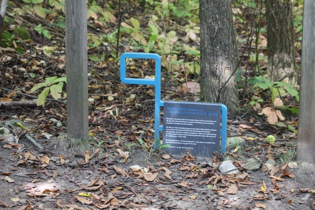
It has been four years since we presented this story and today it would no longer be possible to visit the site.  The current owners have elected to clearly post it.  We present this for it historical value because it is rather unique in the early development of Ontario. – October 1, 2019

In 1863 a survey discovered Medina sandstone in the Caledon hills and soon a plan was put together to market it. The Credit Valley Railroad was chartered in 1871 with the purpose of building a line to access the mineral wealth in the area. The CVR was completed in 1879 along with several spur lines to reach local quarries.  By 1883 the CVR was absorbed into a growing network of rail lines belonging to the Canadian Pacific Railway. Along with spurs, sidings and rail bridges a railway station was built near the hairpin curve on the Forks of the Credit road. To gain access to the stone located in quarries on the Cox Property and the surrounding area,  the railway undertook to construct an aerial tramway. Large pieces of cut stone were lifted off the hill top quarries and carried to the rail line near the station. The Caledon Aerial Tramway opened in 1900 and was in operation for only about 10 years. After the quarries closed the hills were allowed to regenerate with forest cover.

Forks_of_Credit_c.1928_-_Looking_south_across_Forks_of_Credit_Rd_toward_quarry_workers_cottages_west_of_Chisholm_St._-_Peel_Archives___Gallery

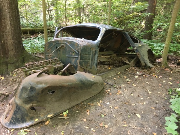
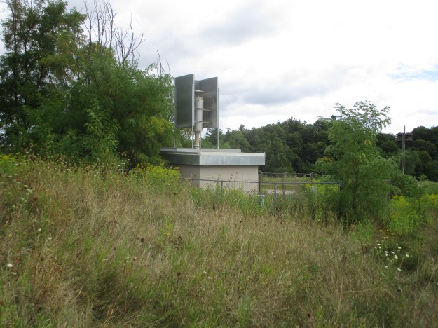
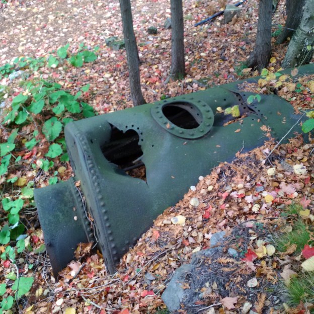
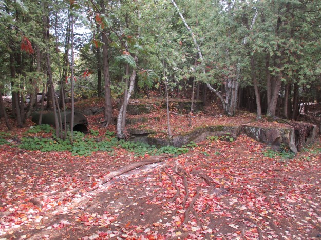
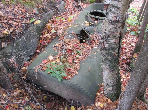
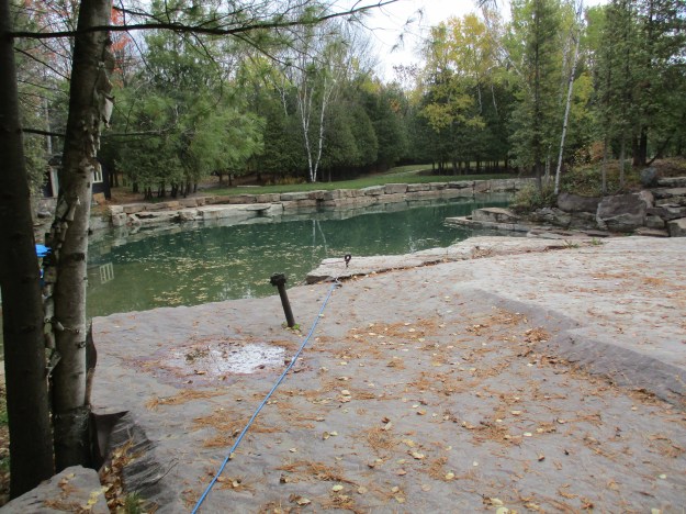
In the late 1800’s The Big Hill Quarry opened on the east side of the Credit River on the top of the escarpment. The quarry site covers 66 acres overlooking Dominion Street. It was an active quarry until about 1910 and was the site of one end of the aerial tramway. The picture below shows the stone pads where the tramway was constructed. Steel anchors can be found throughout the area. To the left is the steam boiler that generated the power that moved the lift on the two inch steel cable.

img_0747

Holes mark the openings where the smoke stack and steam chambers used to stand on top of the steam boiler. As can be seen in the cover photo most of the flue are still in place inside. The boiler is similar to ones used in locomotives built around the same era and the CPR simply employed it’s existing technology in another use. This boiler is a rare example of late Victorian Era technology resting in situ.

img_0751

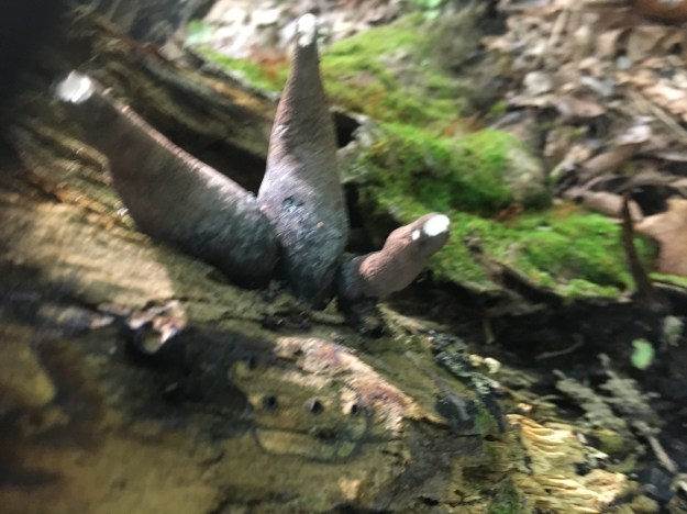
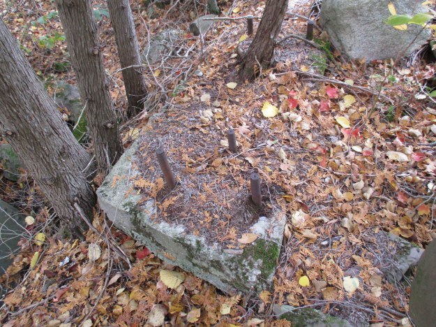
Six steel anchor bolts, in two sets of three, remain just to the right of the boiler.

img_0753

Various steel hooks, eye bolts and anchors remain in the stone around the pond that formed in the old quarry.

img_0763

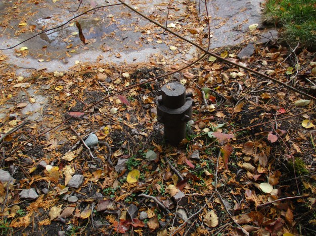
A large steel post remains set in the stone near the steam boiler.

img_0762

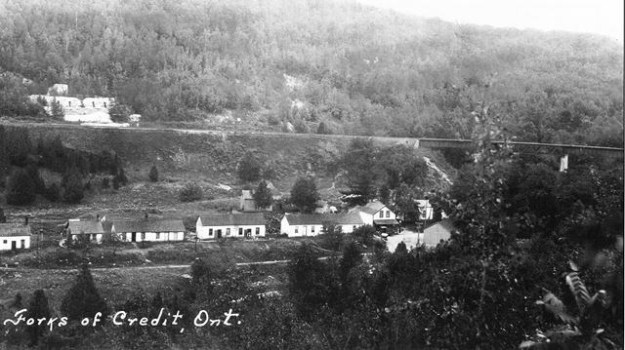
This picture from 1890 shows one end of the aerial tramway.  Our Health and Safety people would have a field day with the guarding on that machine.

TramwayWEB___Gallery

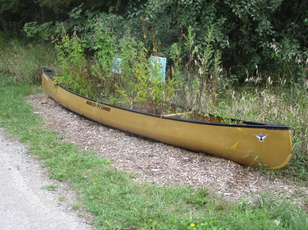
The remains of the Caledon Aerial Tramway are hidden away on private property, at least for the moment.  Here’s hoping another property owner could allow a trail to visit the site.  The receiving end of the tramway was on The Cox Property and you can see some of the two-inch thick cable that we found over there.

Google Maps Link: N/A

Like us at http://www.facebook.com/hikingthegta

Follow us at http://www.hikingthegta.com

Bruce Trail – Hockley Valley

Saturday, September 21, 2019

The Bruce Trail and several side trails wind their way through Hockley Valley Provincial Nature Preserve.  We decided to investigate using two cars.  One was parked at the Bruce Trail lot on Hockley Valley Road.  The second car was left on Dunby Road in another official Bruce Trail parking location.

The trail that leads south from Dunby Road is restrained by fences on both sides.  Along these fences there is extensive Virginia Creeper growing.  It is a member of the grape family but the Greek name for the plant means “Virgin Ivy” from which the name Virginia Creeper is derived.  It can reach heights of up to 30 metres climbing by the use of sticky tendrils sometimes completely covering the tree that is supporting it.  It is one of the first plants to start showing red leaves in the fall.

IMG_7227

Hockley Valley Resort was a small operation in 1985 when it was purchased by the Adamo Family.  Under their management the 28 room hotel was transformed into a world class resort, spa and ski facility.  There are 15 runs and from the start of the trail we had a good look across the valley at them.  As we returned to the car at the end of the hike we found that we had made it almost all the way to the resort.  Some of the ski runs can be seen in the picture below.

IMG_7239

The Gem-Studded Puffball has a a dual layer of spines on the fruit body, one shorter and one longer.  The longer spines detach easily leaving a scar on the surface of the mushroom.  The base is often elongated and sometimes looks like a stalk.  This little fungus looks kind of scary but is said to be a choice edible.  Like any puffball there are look-a-likes that are not edible.  The test is to cut the mushroom in half and ensure the flesh inside is undifferentiated and that there is no sign of gills.

IMG_2125

Yellow Tuning Forks grow from August until November and have a gelatinous texture unlike the brittle corals that look similar.  These jelly fungi are also known as yellow false coral and grow on primarily on pine logs.  They can reach up to 10 centimetres in height which is tall for a slime mushroom.  They can be eaten but their texture and lack of taste make them unattractive for foragers.

IMG_2089 (1)

Northern Tooth Fungus grows primarily on sugar maples.  It gets into the heart of the tree and rots it from within.  These shelf fungus grow annually until the tree is hollowed out and is blown over in a strong wind.  These polypores have long tubes underneath that disperse the spores.

IMG_2098

Dead Man’s Fingers has to be one of the most unusual names for a mushroom.  Sometimes they grow in small clusters which look like a hand reaching up through the ground.  They grow on stumps of maple and beech trees and are whitish in the spring becoming hard and black as the summer progresses.

IMG_2079

Coho Salmon are native to the Pacific Ocean but have been introduced to Ontario and are now naturalized here. When the Europeans arrived in Ontario the salmon crowded the rivers every year.  They spend most of the year in the cold waters of the Great Lakes and return to the rivers and tributaries every year to spawn.  It didn’t take long to destroy the habitats with pollution and to block the spawning routes with mill dams.  The salmon population was decimated and in 1969 it was decided to stock Lake Ontario with Coho Salmon.  Since then all the Great Lakes have been stocked with Salmon and each fall they can be seen fighting their way through the shallow waters of the streams to reach their spawning areas.

IMG_7276

The trail winds through the woods following a couple of ravines.  There are several little bridges that it uses to cross tributaries of the Nottawasaga River.  The largest one carries the water that has come over Cannings Falls which we didn’t visit because it is on private land.

IMG_7278

Wolf’s Milk Slime is similar to a small puffball in the method of spore release.  They will develop a small hole in the top for the distribution of their spores when they are ready.  When this slime first appears it has the consistency of paste but it becomes powdery as the spores mature.  It is also sometimes called Toothpaste Slime.

IMG_2095

Nearly 2 kilometres from Hockley Valley Road are the remains of a 1939 Chevy Sedan that are being slowly disassembled and removed.  The property belonged to Dennis Nevett who owned and farmed it until 1974 when he sold it to the government for the creation of the Hockley Valley Provincial Nature Preserve.  The family used the sedan from about 1951 until 1959 when it died.  Over the next year or two it was towed to the back corner of one of the fields and left to rust away.

IMG_2110

Pretty much everything that can be removed has already been stripped off of the car.

IMG_2109

The Jeju Olle walking trail is the most popular hiking trail in the country of South Korea.  It has over 200 kilomtres of trails that work their way around an island up to the brim of an extinct volcano.  In September of 2011 a section of the Bruce Trail in Hockley Valley was twinned with the Jeju Olle Trail.  To mark the start of the twinned section there is a blue pony which is the marking system used on the Korean Trail.

IMG_7293

This trail promises to be very beautiful in the next few weeks when the fall colours are at their best.

Google Maps Link: Hockley Valley Provincial Nature Preserve

Like us at http://www.facebook.com/hikingthegta

Follow us at http://www.hikingthegta.com

Lakeview Park

Tuesday, September 17, 2019

Lakeview Park is part of the remediation plans that are being implemented at the site of the former Lakeview Generating Station.  The park as well, as a new community, will replace the generating station which was demolished in 2006-2007.  The new Lakeview Village is expected to be home to as many as 17,000 residents.  The old industrial site is now a brownfield where the soil is full of toxins.  Lakeview Community Partners are using sunflowers to absorb the toxins as they are phytoremediators which store the toxins in their stems and leaves.  Twenty-five pounds of sunflower seeds were planted in five areas covering 71 acres.  These seeds have produced over 1 million sunflowers which have become a major attraction for pollinators and photographers.  To check it out we parked in the free lot at 800 Hydro Road in Mississauga.

IMG_7038

Each sunflower can have between 1,000 and 1,400 florets which, if pollinated, can turn into seeds.  That means there could be over 1 billion sunflower seeds in these fields.

IMG_7035

The sunflowers are growing in in random rows and other meadow flowers have sprouted up in between them.  Purple asters, as well as the field thistle in the cover photo, are attracting all kinds of butterflies including Painted Ladies.

IMG_7107

The Painted Lady on this sunflower shows how the upper wing pattern differs from the under wing pattern seen in the picture above.

IMG_7078

This clouded suphur was one of many we saw in the grasses along the edge of the sunflower fields.

IMG_7121

There were lots of butterflies and that provides food for the praying mantis who loves to dine on their larvae.  The mantis will eat almost any caterpillar including the toxic larvae of the monarch butterfly.

IMG_7023

The monarch butterfly population in this area looked pretty good except that the ones we saw were almost exclusively female.  The male monarch has a set of spots on the hind wing that represent scent sacs used to attract the females.

IMG_7076

The common blue damselfly is just one of the varieties of damselflies and dragonflies that abound in the park.  Damselflies can be distinguished from dragonflies in the position of the wings during rest.  The damselfly will fold its wings up while a dragonfly leaves them extended.

IMG_7129

Although there is a loss of honey bees in general there was no shortage of bees in the goldenrod in the park.

IMG_7007

We walked down to the lakeshore and along the Waterfront Trail for a short distance.  Several swans were swimming in the lake near the mouth of Cooksville Creek and we noted that they had not been tagged.

IMG_7093

The Ridgetown can be seen where it is half sunken at the mouth of the Credit River in Port Credit.  The view across the harbour is nowhere near as attractive at the one behind us in the park.

IMG_7085

Lakeview village will be developing over the next few years and it will be interesting to see what the final community looks like.  For now, it is alive with insect life.

Google maps link: Lakeview Park

Like us at http://www.facebook.com/hikingthegta

Follow us at http://www.hikingthegta.com


German Mills Settlers Park

Saturday, September 7, 2019

The community of German Mills didn’t last very long and there is only one building left standing.  We decided to investigate the area which has now become a park and we found free parking on the end of Leslie Street where it has been closed north of Steeles Avenue.

The county atlas was drawn in 1877 and by that time there was no longer a community named German Mills.  The school was replaced in 1874 with a new building on German Mills Street but it is the last remaining structure from this early settlement.  On the map below Leslie Street is brown while John Street, a given road, is yellow.  German Mills Creek is in blue while our hike is roughly outlined in green.

German Mills (2)

Jack in the pulpit grow for up to 100 years from their corm, a type of root similar to a small turnip, although basically inedible.  They spread through seeds that are grown inside their berries.  The berries will turn from green to red when the seeds are ready.  The berries can be harvested and the seeds gently squeezed out.  There will usually be 4 to 6 seeds in each berry.  These can be planted about 1/2 inch deep in the fall.

IMG_6505

German Mills was settled in 1794, the year following the founding of York (Toronto) by a group of German families.  They not only established the first industrial complex in Markham but set an early example of the development of Canada through a multicultural approach.  The settlement didn’t last long because the water supply was inadequate to power their mills.  The picture below shows a sketch of the settlement that can be found on an interpretive plaque along the trail.

IMG_6526

The main paved trail crosses German Mills Creek but we chose to follow the old road allowance for Leslie Street.  German Mills Creek appears to have a few minnows in it but not much else.  The creek runs for about 10 kilometres before emptying into the East Don River in the East Don Parklands.

IMG_6704

Pheasant’s-back Polypore is also known as Dryad’s Saddle and is one of the larger polypore mushrooms found in Ontario.  The caps can reach 12 inches or more with the example seen below coming in at nearly 13 inches.  Although this mushroom is edible it is also rather tough and rubbery.  The outer edges are sometimes pickled or fried and are reported to taste like watermelon rind.  They are common from May until November and they seem to have been quite prolific this year with some trees having had several crops growing on them already.

IMG_6502

On the county atlas above the lots belonging to John Lane and G. C. Harris have been outlined in black.  A large portion of each of these lots was used for gravel extraction between 1940 and 1960.  When the aggregate supply was exhausted the empty pit was converted into the Sabiston Landfill.  From 1960 to 1975 the landfill operated with no records of what types of materials were dumped there and in which sections.  The site continues to produce methane gas that is released into the air and leachate which enters the groundwater.  Today there is a one metre clay cap over the landfill and the area has been designated as the German Mills Meadow and Natural Habitat.

IMG_6509

The mound that represents the former landfill is now monitored for discharges.  A decade ago the Town of Markham was considering installing an aerobic system to help speed up the elimination of methane and leachate from the site.  Local residents protested the plan based on the fact that methane was below the 2.5% level that the Ministry of the Environment sets as safe.  The community succeeded in 2012 in getting the plan halted by arguing

IMG_6511

We found another one of these old canoes which has been planted to help encourage pollinators to do their thing.

IMG_6513

The community of German Mills constructed a one room log school to serve the children of the community.  In 1874 it was decided to replace the school with a larger board and batten structure.  The school was built with separate entrances for the boys and girls as was common in the Victorian Era.  One of the interesting features of the architecture is the way the batten curve into scallops under the boxed cornice of the roof.

IMG_6524

Originally known as school section number 2 there were over thirty different teachers who served here between 1874 and 1962 when it closed.  The original bell still hangs in the bell tower.

IMG_6726

One of the notable teachers from the school was Leonard S Klink who taught here in the 1890’s.  He was responsible for getting the students to plant rows of spruce trees around the sides of the property.  These trees continue to mark the outline of the school yard.  Klink went on to serve as the President of The University of British Columbia from 1919-1944.

IMG_6521

Poison ivy seems to have had a good year and there is plenty of it in German Mills Settlers Park.  The sap contains a substance known as urushiol that usually causes a reaction within 24-48 hours.  Controlling poison ivy by burning it can be very dangerous because inhalation of the smoke can cause the rash to develop on the inside of the lungs.  This can be very painful and possibly fatal.

IMG_6729

Bur Oak is a member of the group of white oaks and is also known as mossy cup oak.  The tree typically reaches 30 metres tall but has been known to be as large as 50 metres.  Like most oak trees they grow slowly but can live for up to 400 years.  The acorns are also large growing up to 5 cm in size.  These trees produce a heavy crop of acorns every few years in a process known as masting.  This bumper crop overwhelms the ability of the local wildlife to consume the acorns and ensures the survival of some seeds.

IMG_6530

German Mills Settlers Park is about to undergo construction work to prevent erosion from damaging the sewer pipe that runs along the length of the creek.  This will change the natural look of the creek for several years.

Google Maps Link: German Mills Settlers Park

Like us at http://www.facebook.com/hikingthegta

Follow us at http://www.hikingthegta.com

Cooksville Creek

Monday, September 1, 2019

Cooksville Creek in Mississauga has its entire watercourse within the city and in fact it even flows under Square One Shopping Centre.  Over the years it has come under great stress as a result of the changing nature of the watershed development.  With so much of the surrounding areas now paved over and developed the flash flooding of the creek has become a serious problem leading to erosion and property damage.  There are 304 buildings in the lower watershed that are subject to flooding in a 100-year event like Hurricane Hazel.  The city is currently implementing new flood control measures including widening of the creek bed south of Mississauga Valley Boulevard.  We found free parking at the Mississauga Valley Community Centre.  From there we went to explore the construction of the flood controls on the creek.

IMG_6500

The main flow of Cooksville Creek has been diverted into a pipe while they widen and deepen the channel.

IMG_1762

The woodlands on either side of the ravine are home to a large population of squirrels.  There is a constant food supply for them in the cone and nut trees and both black and red squirrels can be seen collecting food for their winter supply.  Having a good food supply for one species means that they will become a good food source for another predator.  We saw this red-tailed hawk sitting in a tree keeping an eye open for breakfast.

IMG_6621

The danger exists in the air from the hawks and on the ground from the coyotes.  The mud in the exposed creek bed has been crossed over many times with coyote tracks.

IMG_1763

The river grapes are starting to ripen along the sides of the trail.  The crop this year looks to be doing very well with lots of fruit for the wild animals to feed on.  Coyote feces that we see along the trail seems to contain a lot of seeds and fruit husks and this isn’t unusual in the summer and fall as they supplement their diet.

IMG_6602

The lower part of this reach was reworked a couple of years ago to increase stability of the sides and create retaining pools to hold the water during flood events.

IMG_6581

The transition point between the section that was completed and that which has not been touched recently.  Although some sections appear to be quite naturalized they have in fact all been subject to more than one repair since the creek was urbanized in the 1940’s.  Of the 14.9 kilometres of creek there are only 1.2 kilometres that are natural while there are a full 35 kilometres of gabion baskets which are failing.  The flood water has washed in behind them in places causing them to collapse into the creek, further diverting the flow and causing more erosion.

IMG_6584

The mallard ducks that were born this spring have now become fully grown.  We were enjoying watching them walk up the little waterfall in the creek.  Over the years the repairs to the stream have reduced most of the natural pools and riffles in the watercourse.  This is one of the places where the water gets oxygenated.

IMG_6597

It’s the last weekend of the Canadian National Exhibition which always features the famous air show.  On the way back home I would be treated to a squadron flying in formation on their way back to the airport.  Just as the airshow marks the end of the CNE and the unofficial end of summer, nature’s air show marks the return of fall.  We saw a gaggle of geese flying in the “V” formation that they use when flying south,  The strongest birds fly in front while the weaker ones follow in their wind currents.

IMG_6613

There are sections that have not been subject to heavy equipment in recent years.  The undergrowth in these areas is first generation of trees.  There are no large oak or maple trees that one would find in a succession forest.  Where the work was completed in the past few years there are newly planted trees that may some day provide a mature forest.  For now the trees are stripped back away from the edge of the creek so that there is no shade over the water.  This leads to higher water temperatures and destroys the habitats.  Cooksville Creek is essentially a dead creek with nothing but a few water skimmers in the upper reaches.  This loss of riparian vegetation is a contributing factor to the decline of the Red-Sided Dace in the past 30 years.  At one time they would have been populous in Cooksville Creek as they were in most GTA waterways.

IMG_6493

At this time you can’t walk the entire course of Cooksville Creek due to the construction work.  We went through anyway and although it was a holiday Monday there was someone on site who ignored us.  Once you get south of the railway tracks there is a large green space that was formerly occupied by several homes.  This is an interesting place where you can find foundations and driveways that are being overtaken by the new growth of vegetation.

IMG_6499

This area was accessed by Given Road which we have previously described in a post that can be found at the link above.

IMG_1684

Cooksville Creek is a real mess today and you wonder how it can ever recover.  However, if you look closely, every ravine has a set of sewer access points that are dated from the 1950’s and up.  These remind us that there has been heavy equipment in the ravines before and since the infrastructure below will need maintenance at some point, there will be again.

Google Maps Link: Cooksville Creek

Like us at http://www.facebook.com\hikingthegta

Follow us at http://www.hikingthegta.com