Monthly Archives: August 2020

Lambton Mills – Ghost Towns of the GTA

Saturday, August 22, 2020

Lambton Mills has changed considerably since the days when it was a mill town on the Humber River, half in Toronto and half in Etobicoke.  It isn’t a ghost town in the classic sense because so many people still live there but the ghost of the pioneer community is still evident.  To explore we parked in the small lot on the west side of the Humber River at the end of Old Dundas Street.

Lambton

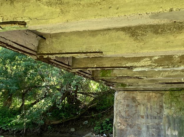
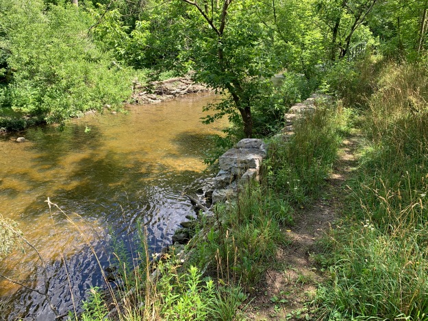
Dundas Street used to cross the Humber River on an iron bridge set on stone abutments.  When the new high level bridge was built Dundas Street was realigned and Old Dundas Street lost its bridge.  The old stone abutments have have been collapsing and there isn’t much left on the west side of the river.

unnamed (15)

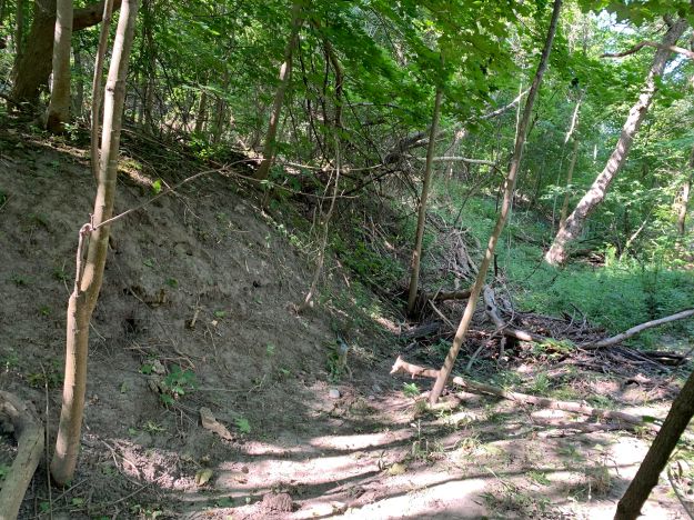
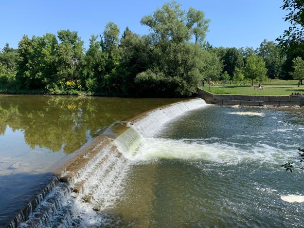
Lambton Mills grew up around several mills and soon became home to blacksmiths, inn keepers and many mill workers.  North of Old Dundas Street you can still find the remains of the earthen berm that was part of the early mill dam in town.

unnamed (20)

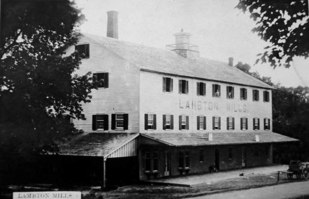
The archive photo below shows the large mill that William Pearce Howland built on the south side of Dundas Street.  Howland went on to be one of the Fathers of Confederation and then served as the second Lieutenant Governor of Ontario.

image1123_orig

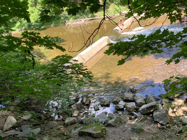
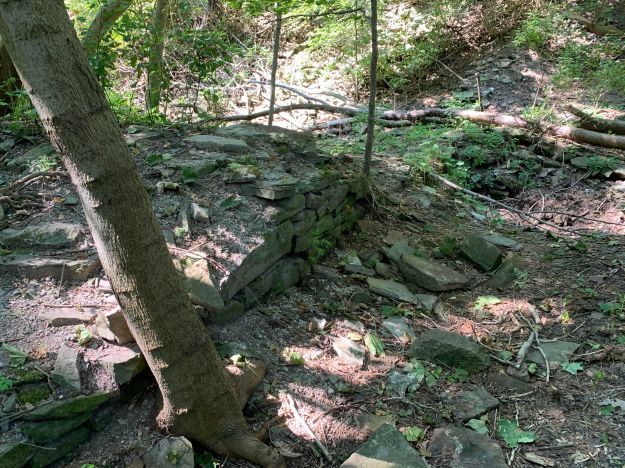
A short walk south along the river brings you to the remains of an earlier dam.  This helps to mark the site of another mill.

unnamed (19)

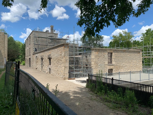
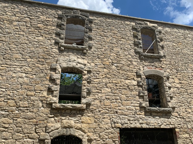
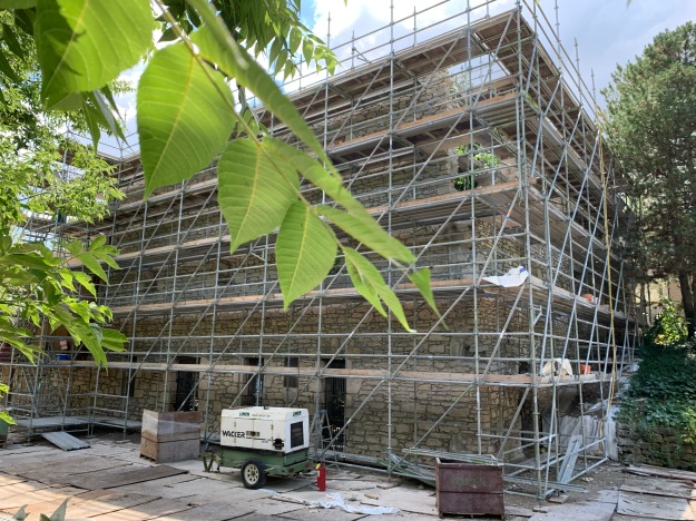
Millwood Mills was built by Thomas Fisher on the west side of the river and south of Dundas Street.  It is shown on the historical atlas as G.M. for grist mill on the Fisher Estate.  The two story mill burned down in 1847 and was replaced with a five story building.  After Fisher’s death in 1874 the mill passed to his son who operated it for four more years before passing away himself.  In 1880 the mill was converted to steam and became eventually became a rope manufacturer named Canada Woolen Mills.  After a fire in 1901 it was permanently abandoned and now exists as a set of stone foundations in the trees.

unnamed (21)


Lambton House was operated as a hotel on the Dundas Road beginning in 1848 as a rest stop and watering hole for travelers and horses alike.  It served as a hotel for 140 years until closing in 1988.  The property has changed a lot over the years and high rise apartments now stand all around the hotel and on the former site of the mill.  The building itself has also changed over the years.  Looking above the rear door on the east end of the building you can see where there is a set of lines that form an upside down V below the roof line.  Lines like this can often be seen on older homes where a former porch has been removed.  In the case of Lambton House, the pioneer equivalent of a garage was attached at the back of the hotel.

unnamed (11)

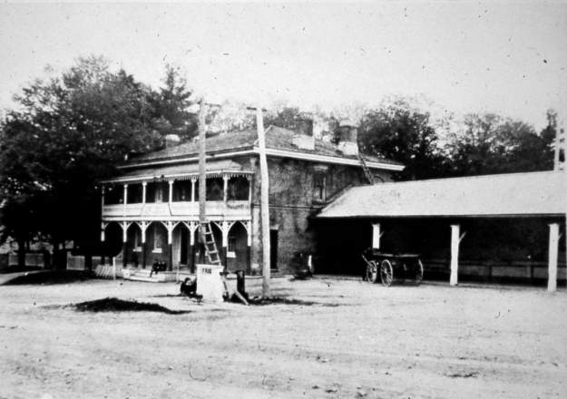
The photo below from the Etobicoke Historical Society shows the hotel as it appeared a century ago.  The rear entrance on the side led directly to the drive shed where the horses sheltered.  It certainly is a more attractive hotel without the apartment buildings in the background.

Lambton House

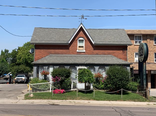
Thomas Colton owned one of the two blacksmith shops on Dundas on the west side of the river.  It was here that he built his story and a half family home complete with a rounded window in the front gable.

unnamed (14)

The Methodist congregation in Lambton Mills needed a new church building and local architect Meade Creech designed and built one for them in 1877.  The first services being held on March 3, 1878 in the new brick building with Gothic architecture and a large rose petal window above the main entrance.  The congregation joined the United Church in 1925 and soon needed a new building.  The old one was sold and a new retail addition was put on the front and it was turned into a store.  The city of Toronto has over 4,500 properties on their heritage register.  This means that they cannot be altered without city council approval.  There’s another 11,700 properties that are heritage listed which means that although they have been recognized as having heritage value they are basically unprotected.  Developers must give the city 60 days notice of their intention to demolish a listed building.   From the vacant lot that now exists where the church used to be it seems those 60 days have passed already.

unnamed (12)

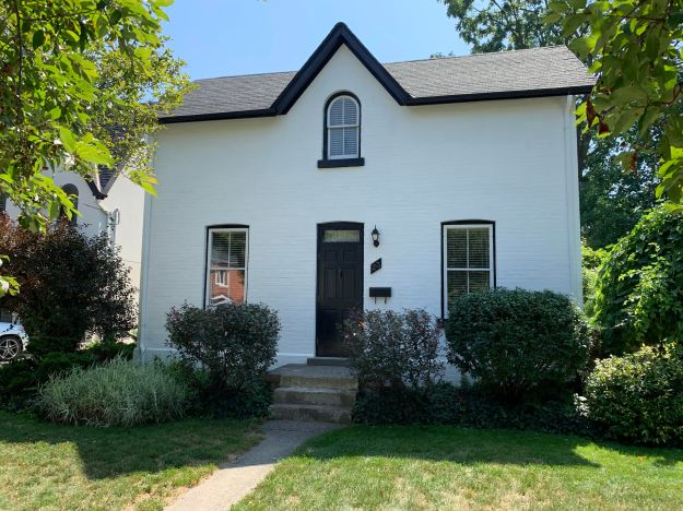
The house at 30 Government Road was built in 1870 for Harry Phillips who was the postmaster for the town.  This little house has a rounded arch window in the upper gable that is typical of Lambton Mills and a feature of Italinate architecture.  The four leaf clover motif in the bargeboard on the gable is also typical of the era.

unnamed (13)

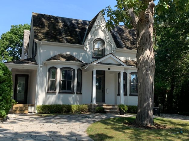
John Berry took over running Millwood Mills in 1890 and two years later he built his house at 125 Kingsway.  The mill failed and in 1894 he moved to Quebec to run a textile mill there.  He returned to Lambton Mills in 1914 and became treasurer of Etobicoke in 1918.  He served as treasurer for twenty years, walking to Islington every day because he never owned a car.

unnamed (16)

A pair of historic homes stand at 7 and 9 Government Road where mill workers lived during the mid-1800’s.

unnamed (17)

Another historic home stands at 23 Government Road.  This simple one and a half story house has the Lambton Mills vernacular gable window with a rounded arch.

unnamed (18)

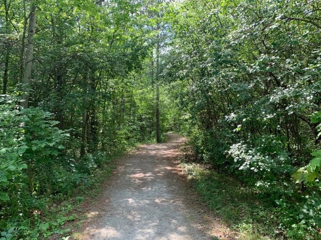
Lambton Mills has been totally surrounded with development but there’s still a large number of historic buildings on the west side of the Humber River.  A walk through the area reveals many old gems complete with beautiful gardens.

Also see our feature Old Mill to Lambton Mills as well as the story of Millwood Mills

Google Maps Link: Lambton Mills

Like us at http://www.facebook.com/hikingthegta

Follow us at http://www.hikingthegta.com

Also look for us on Instagram

Marylake

Saturday, August 15, 2020

Sir Henry Pellatt was instrumental in bringing electricity to Toronto from Niagara Falls and invested in railways to accumulate his fortune.  He started to build Casa Loma in Toronto in 1911 and also purchased a large tract of land in King Township where he built his country retreat at the same time.  He honoured his wife Mary Pellatt by naming the property Lake Marie.

Pellatt built in stone and worked to match the feel of Casa Loma and that included having a set of stone gates right at the corner of Keele Street and 15th Sideroad.  This was the original driveway into the estate but since the lane was moved a few meters west a statue of  Mary has been installed in front of the gates.

Gates

The gatekeepers house was also built of stone and this little story and a half home was designed to compliment the mansion that was being built near the lake.

gatehouse

Henry Pellatt built an elegant estate home where he could relax with his wife and enjoy the country lifestyle.  He entertained the Eaton family and hosted riding and hunting parties for high profile guests including Prime Minister William Lyon Mackenzie King.

House

The estate house features towers and a turret like his main home at Casa Loma.

Tower

Pellatt build a large barn out of bricks rather than the typical wooden structure found on most farms.  Everything about the barn was done on a grand scale including the two large silos which were topped with wooden cones.  Many windows have been broken and the cones have caved in but the long term plan is to restore the barn and possibly use it for events.  The front door to the barn is set in an alcove with a recessed pattern in the bricks above it.

door

Pellatt operated a dairy farm while he lived on the property but in 1935 he was forced to give up his estate.  In 1942 the Augustinians acquired the property for their monastery and they continued the farm operations.  They changed the name to Marylake.

dairy

The maintenance sheds are extensive but appear to be lacking in maintenance themselves.  The far end of the sheds has a small former office in it as well as being used for the current maintenance of the grounds.

Shed

The gift shop is located in a log cabin that has an extension on each end and a small entrance porch.  This section of the property was listed as belonging to T. H. Ince in 1877 and the central part of this cabin was likely built from the trees that were cut when the land was cleared.  Although the corners are tightly dovetailed, the logs themselves show the marks of being hand-hewn.

cabin

In 1945 the Augustinians held their first mass at Marylake and since then have continually upgraded the property to make it a site of pilgrimage for thousands of people.  The Shrine of Our Lady Grace at Marylake has three levels and is built of field stone collected on the property.  The building was completed in 1964 and features a 100 foot tower with a wall of stained glass windows.

Church

The Great Crucifix at the start of the Rosary Path is one of the newest features of the site having been completed in 2016.

cross

The Rosary Path was developed in 2014 with the ground breaking ceremony being held on September 6th.  The Rosary Path is 1.5 kilometres long making it the largest rosary in  the world.  A rosary generally has sets of ten beads known as a decade.  There is an additional large bead for each decade and including the beads that attach the crucifix there is a total of 59 beads on a five decade rosary.  The 59 beads along the Rosary Path have each been donated.

rosary

The beads are designed so that you can kneel in each one as you pray your way along the rosary.

bead

Along the Rosary Path is also a display of the fourteen stations of the cross beginning with Jesus being condemned and finishing with laying Him in the tomb.

empty

Marylake has become a place of pilgrimage for Catholics from all around the world and will continue to draw the faithful for years to come.

Google Maps link: Marylake

Like us at http://www.facebook.com/hikingthegta

Follow us at http://www.hikingthegta.com

Also look for us on Instagram

Nashville Conservation Reserve

Saturday, August 8, 2020

The Nashville Conservation Reserve is made up of over 900 hectares of land that was bought up by the Conservation Authority in the 1960’s and 1970’s.  In the aftermath of Hurricane Hazel there were plans to create several large flood control reservoirs.  The lands in this conservation reserve would have been developed into a large pond created by damming the Humber River.  Funding wasn’t made available and the property was left to passive recreational uses.

On a previous visit to the Conservation Reserve we had followed the old road allowance for Kirby Road and had not ventured too far into the actual park.  We returned to do a further exploration, once again parking at Kirby Road and Huntington Road.

unnamed

Structurally the bridge is in bad shape.  The steel reinforcement is exposed everywhere and large chunks of concrete have already fallen away.  The TRCA Management Plan for Nashville Conservation Reserve included a clean-up of the bridge in 2015 that removed a lot of the deteriorating concrete.  A similar bridge over the Humber River on Old Major Mackenzie Drive serves a single house on the one side of the bridge.  The City of Vaughan is legally responsible to maintain the bridge for the family that lives there.  It is estimated that it will cost about $800,000 dollars to repair that structure.

unnamed (9)

As we saw on our previous visit to the reserve the bridge no longer serves anything but pedestrian traffic on the Humber Valley Heritage Trail.  Kirby Road through this section was abandoned in the 1970’s and the bridge closed to vehicular traffic.  With the cost of repairs likely to be similar to the Old Major Mackenzie bridge it looks like the days of this bridge are numbered.  The official plan is to permanently close the trail on both sides of the bridge sometime in the next few years.  The view from below the bridge supports the idea that it should be removed before it collapses into the river and creates a flooding obstacle.

unnamed (1)

With the spread of dog-strangling vines and the subsequent decline in common milkweed it was feared that monarch butterfly populations could suffer decline.  It appears from personal observation that this year has been good to the butterfly population and there are plenty of examples to be seen every time we go out hiking.

IMG_8478

Just past the bridge and near the top of the hill we made a left turn to enter the northern loop trail through the woods.  Trails are marked with blue slashes and were all but deserted as we made our way along.

unnamed (7)

Northern Tooth fungus is typically found on Maple Trees where it grows in densely packed shelves from wounds in the tree.  Over time it kills the heart of the tree leaving it hollow and susceptible to being blown over in strong wind storms.  One of the trees along the trail has several large patches growing out of it but it appears that it is the only tree in the area to be suffering from this fungus.  Undoubtedly this tree has already been destroyed, it just hasn’t fallen over yet.

unnamed (3)

The carrots we enjoy at dinner time are cultivars of wild carrots, also known as Queen Anne’s Lace.  A cultivar is a plant that has been selected because it has a desirable trait that it will continue to pass along.  The trait that has been cultivated from the wild carrot is our domesticated carrot.  The flowers on Queen Anne’s Lace are white and clustered in dense umbels.  Among all the white flowers was a single plant which had all four or five umbels that were pink coloured.

unnamed (5)

Artist Bracket or Artist Conk is a bracket fungus that grows on trees where it decays the heart of the tree.  When they are young they are white but quickly turn darker as they age.  When the spore bearing surface below is scratched it forms dark lines that become permanent when the conk dries. Artists use these to create permanent pictures.

unnamed (6)

There were several small mushrooms growing in a cluster at the base of a rotting log.  Orange Mycena produces an orange pigment known as leinafulvene.  It has been shown to have antibiotic properties as well as being toxic to certain tumor cells.

unnamed (8)

Nashville Conservation Reserve is still largely unexplored and we’ll have to come back sometime to see what is happening with the old bridge.

Google Maps Link: Nashville Conservation Reserve

Like us at http://www.hikingthegta.com

Follow us at http://www.hikingthegta.com

Also look for us on Instagram

The Cober Dunkard Church

Friday, August 7, 2020

Jacob Engle was one of the founders of the Dunkard sect of Mennonites in Pennsylvania and in 1808 was organizing settlers in York County.  Meetings were held in homes for the first 80 years even though a large Meeting House was built at Heise Hill in 1877.  Gormley was about 10 miles away and people in the area west of Yonge Street continued to meet in homes for the next 11 years.  Sixteen families hosted the church including that of Peter Cober (green on the map below) and several different Baker, Boyer, Doner and Heise homes.  Mennonties and other Anabaptist denominations were known for their belief that anyone baptized as a child needed to be re-baptized as an adult.  The Dunkards were named because of their belief in “dunking” people through immersion.

Cober

In 1839 Peter Cober donated a small parcel of land on his property at Lot 12, Concession 2 in Vaughan Township for a cemetery.  Today it is known as the Baker-Cober Cemetery because the land was donated by the brothers-in-law Peter Cober and Michael Baker. Although it contains the remains of some of the first settlers in the area the cemetery is still active with the most recent burial being in 2010.  One of the truly unusual aspects of this cemetery is the pioneer styling of some of the recent burials.  They seek to keep the simplicity of the earliest buries including the tradition of reporting how long a person lived.  Today we tend to record birth and death dates.

In 1888 the congregation decided that it was time to build a permanent place of worship.  By this time the property had passed into the hands of George Cober.  He donated land south of the cemetery for the construction of a church.  Nicholas Cober constructed the building of white pine with no adornment.

The floor remains the way it was built without even the adornment of a coat of paint.  The benches and the stove provided a minimum of comfort and in the winter the congregants would sometimes sit closer to the stove.  On October 21, 1888 the first service was held in the new church but records from George Cober indicate that house meetings continued into 1896.

Peter Cober attained the position of Bishop in the church and conducted services in homes for many years.  It was Bishop Cober who introduced services in English in 1860.  Even as the German services were being replaced, the custom continued until 1916 of closing the service with a hymn sung in German.

The pioneers had to travel across roads that were often muddy or snow packed by horse and carriage.  A drive shed was added to give a place to shelter the animals during the service.  The Cober Dunkard church shed is the only surviving church shed in Vaughan Township.

They don’t park horse and buggy here as much anymore and so the space is in use for washrooms which are not provided in the little structure.  The cubicle that can be seen at this end of the shed is the ladies washroom while the outhouse for the men is at the other end.

George Cober was likely born at home on this piece of property in 1826, as was the custom at that time.  He continued to farm the property when his father passed on and in 1916 he passed on.  His burial service was conducted in the church that he donated the land for and then he was buried in the graveyard that bears his name.  I imagine that George saw relatively little of the world outside his community.

img_5072

In 1935 services were switched from every two weeks to just monthly and now the church can be used by appointment only.

Google Maps Link: Cober Dunkard Church

Like us at http://www.facebook.com/hikingthegta

Follow us at http://www.hikingthegta.com

Also look for us on Instagram.

Maple Nature Reserve

Saturday, August 1, 2020

Maple Nature Reserve is 35 hectares of the Oak Ridges Moraine near Dufferin Street and Teston Road.  Much of the property was used as a Ministry of Natural Resources office complex including and old quonset hut that had been decommissioned and has since been removed.  Access can be had from four locations but I had decided to look at it on my lunch on Friday and so I parked at the lot beside the old ministry building on Dufferin Street.  I went for a brief walk and got my first ever picture of a Yellow-billed Cuckoo which assured that I would return on Saturday to see what other surprises the reserve held.

Yellow-billed Cuckoo are distinctive in their call and are hard to spot because they will stand still and even hunch down to try and hide heir white bellies.  They are helpful to the forest because they are one of the few birds that can eat hairy caterpillars.  They can eat as many as 100 tent caterpillars in a single meal.  You might also find them feasting in an area where there are a lot of cicadas.

IMG_8389

The ministry building is currently vacant with all the services, including City of Vaughan Archives, having moved to city hall.  It is just one of the buildings on the site that is awaiting decision of its future.  The trail down the hill from here leads to a larger parking lot and some washroom facilities.

For Saturday’s adventure I decided to park in the circle that can be found in the first driveway east of Dufferin Street on Teston Road.  This leads to the Arboretum Trail which loops around most of the northern section of the nature reserve.   The trails are wide but climb up and down the moraine and although sections like the Arboretum Side Trail claim to have steep sections they are quite manageable.

img_4952

At one point along the trail there is a cluster of Veitch’s Blue Globe Thistles.  These produce a flower head the size of a golf ball  and a few of them were starting to open.  Globe Thistles have lovely flowers considering the less desirable prickly leaves on them and have been imported for use as garden flowers.  This escape is attracting a hover fly that is coming in to look for pollen.

Where the East Don flows through the park there are a couple of old buildings sitting near a small pond.  These have been shuttered most likely awaiting demolition as the area is slowly re-naturalized.

It was a nice day for the Painted Turtle to crawl up on a log in the pond and start basking.  Water is a poor conductor of heat and so turtles will crawl up onto a log and soak up heat from both the log and the sunshine.  This allows them to regulate their body temperature to between 32 and 35 degrees celsius.  Basking also allows a turtle to absorb UVB which is needed for the absorption of calcium and it allows them to dry out causing leeches and parasites to fall off.

IMG_8396

South of the parking lot is the area that once held a quonset hut and parking lot used by the ministry.  Both have been removed and the area has been contoured to allow for pools to form when there is a lot of rain.  Known as Ephemeral Ponds the shallow spots also fill up with water in the spring when the snow melts.  They provide small habitats that are suitable for amphibians that come to eat the insects that abound when the ponds are full.  If you come at the right time you have a chance to see Spotted Salamanders in the ponds at Maple Nature Reserve.  The trails in this section of the park cross the Don River on a new foot bridge and boardwalk.

Scarlet Waxy Cap have a slimy cap with waxy gills and white spores.  They are sometimes referred to as Scarlet Fading Waxy Caps because the colour will fade to yellow as the mushroom ages.  They are considered edible but as always we leave the plants to do their natural cycle in the hopes that others will enjoy seeing them or subsequent generations.

With just over 3 kilometres of trails this is an area that can be completed in a single trip providing you do a couple of sections twice.

On your way to Maple Nature Reserve you may well pass the last church drive shed in Vaughan Township at the Cober Dunkard Church.

Google Maps Link: Maple Nature Reserve

Like us at http://www.facebook.com/hikingthegta

Follow us at http://www.hikingthegta.com

Also look for us on Instagram

Goldie Mill Guelph

Saturday, July 25, 2020

Goldie’s Mill ruins in Guelph are part of a legacy that goes back to 1827 when David Gilkison built a sawmill on this site beside the Speed River.  Two doctors built a grist mill named Wellington Mills in 1845 but W. Clark and H. Orton lost their mill to a fire just five years later.  The mill was rebuilt in stone and given a new name, The People’s Mills.  After this new building burned in 1864 the land was bought by James Goldie.  He expanded the mill and completed a new stone building in 1866.  The Wellington Archives post card below shows the mill as it appeared in the early 1890’s.

08081

The Goldie family continued to operate and expand the mills until 1918 when they sold the operation.  It continued as a mill until the spring of 1929 when a flood washed out the dam.  The building was once again destroyed by fire in 1953 and has been left as a ruin ever since.  The picture below shows part of one wall.  The limestone that was used in the construction was all quarried and dressed on the site.  The masonry around the windows is quite impressive.


IMG_4799 (1)

Over the years the site added a cooperage to make barrels to ship the ground flour in as Goldie’s Mill became one of the primary producers in the area.  James Goldie was well respected and even served as the President of the Canadian Millers’ Association.  A foundry, tannery, piggery and distillery were all part of Goldie’s operations over the years.

IMG_4798

Industrial uses over the years have left the soils on the site with contamination and the work of the weather and the Speed River have created several sink holes.  For this reason the city decided to fence the site to keep the public out while they did further assessments.  It was found the most of the chemical waste on the mill site was about 0.75 metres below the surface but was somewhat less in some places.  The remediation plan includes adding a membrane where the soil is thin and then new soil and mulch.  This will fix the sink holes and eliminate any human impacts from the chemicals in the soil.  It is expected that the soil and sink hole repairs will cost $450,000.

IMG_4804

The building is also being stabilized and repaired so that it will be safe to use by the public.  The site has become popular for weddings which are expected to resume in the park in 2021 if the work is completed by then and there are no other delays.

IMG_4808

There are ruins on both sides of the Speed River and large sections of foundations are buried along the north and northwest sides of the building.

IMG_4811

The brick chimney sits on a foundation of cut limestone blocks.

IMG_4813 (1)

The 90-foot tall chimney is part of the heritage designation and has already been restored.  There is a plan to relocate a pair of Chimney Swifts to take up residence on Goldie Mill chimney.

IMG_4792

The remnants of the mill dam are in the river just upstream from the mill ruins.  The previous dam and mill pond were much larger than those left today.

IMG_4814

Across the street from the mill is the only other piece of architecture on Cardigan Street to survive from the 1850’s.  It was built in 1853 as a tavern and home for Bernard Kelly.  It was the common drinking hole for workers from the mills that operated along the river.  When Kelly died on 1882 James Goldie bought the place and rented it out as accommodations for some of his workers.  In 1911 the old inn was once again up for sale and this time it was purchased by the Stewart family who lived there until 1988.  It was eventually restored in 1996 to the original splendor.

IMG_4815

The picture below shows Kelly’s Tavern as it appeared in 1977, prior to restoration.  Notice that the door on the right has been closed and bricked in and all of the window shutters have been removed.  It has since been renovated and turned into four little apartment units.

1977

It will certainly be interesting to see how the restorations turn out and what has been done to preserve the building for future generations to enjoy.

The Rockwood Woolen Mill in Rockwood Park are also well worth a read and a visit.

Google Maps Link: Goldie Mill Guelph

Like us at http://www.facebook.com/hikingthegta

Follow us at http://www.hikingthegta.com

Also, look for us on Instagram