
Saturday, May 13, 2017
Nemo is a Latin word that means “no one”. When a post office was opened at the corner of Base Line and Guelph Line no one could think of a name for the community and so Nemo was chosen. The post office and community are gone but since 1971 there has been a conservation area called Mount Nemo that carries on the name.
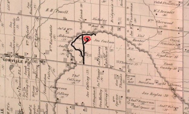
In the 1877 county atlas Lot 3, concession 4 of Nelson Township belonged to three different people. The front 100 acres belonged to Jos. T Blagdon while Benjamin Eager owned the portion of the east 100 acres that was on top of the escarpment. Below the escarpment, Nathan Lamb has added the most arable part of the east half to his farm. It is Benjamin’s lot that would become the quarry that produced the park. There are park fees of $6.75 per adult to get into the conservation area to park. We hiked the route marked in black on the map and made a visit to the abandoned Lowville Quarry marked in red.
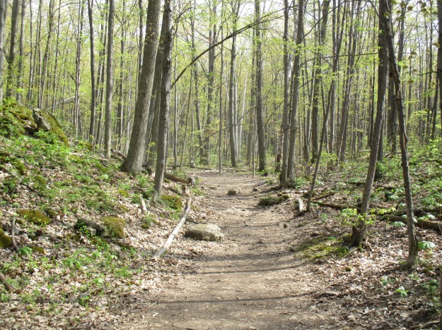
The sides of the trail are brightly coloured with springtime flowers and the trees are well advanced with their leaves. Large patches of trilliums are mixed with several species of yellow flowers including Large Flowered Bellworts and Yellow Violets.

Along the trail, we noticed a fallen tree and as is our habit we stopped to see what it had exposed. The tree had grown through the limestone and when it fell it broke two large chunks away that remain attached to the bottom of the tree trunk. Close examination reveals a wealth of fossils mainly crinoids and brachiopods.

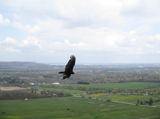
Turkey Vultures were out in large numbers today. They are considered a species of least concern because they are widespread and the population is stable. When a turkey vulture is threatened it defends itself by vomiting powerful stomach acids at its attacker. It is unique among vultures because it finds carrion by both sight and smell. When they are standing on the ground they are often confused with wild turkeys. There are several places along the trails where you can look out and see them circling and riding on the wind currents.
A lookout along the trail is named after Joseph Walter Brock Harris who worked for the Halton Conservation Authority for 31 years. The lookout is about 85 meters above Walker’s Line which can be seen running between the farms on the tableland below. From here you can see Milton, Brampton, Mississauga, and on a clear day, The CN Tower. As a reference, the lookout is about half the height of the CN Tower. You can also see across to the Milton Outlier which is a section of the escarpment that is separated from the rest of the escarpment by the Nassagaweya Canyon which is hidden from view at this distance. There is a series of trails that connect Crawford Lake and Rattlesnake Point by passing through the Nassagaweya Canyon.

A short side trail leads to the former Lowville Quarry. Seventy feet of Amabel Dolomite is exposed in the quarry face from aggregate extraction from 1958 to 1959. An old access road still leads down into the quarry which is becoming overgrown with Paper Birch or White Birch trees. When a forest is regenerating after a fire or clear-cutting the Paper Birch is one of the first trees to colonize.
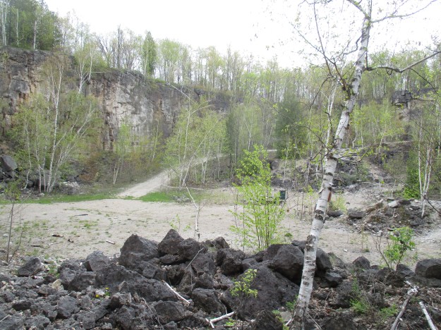
Lowville Quarries was operated by a company called Bay Crushed Stone. The quarry face had holes drilled in it and then dynamite was used to blast the rock chunks free. Along the north wall, there is still a large amount of stone that was blasted from the quarry face but never processed. Stone from this quarry was crushed and used for road construction and concrete aggregate. The quarry only operated for a couple of years before the Twelve Mile Creek Conservation Authority purchased it and 88 acres of surrounding land to prevent the quarry from expanding. Operations ceased immediately and the quarry still has freshly blown rock waiting to be scooped up and crushed. The stone in the picture below has a blast hole for the dynamite.

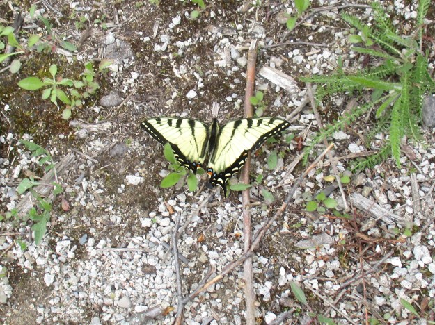
The Eastern Tiger Swallowtail has two or three broods each year. They hibernate during the winter months in the chrysalis state and emerge in the spring as butterflies to start the cycle of life. The female has a full row of blue spots along the hind wings while the male has only four. This male was sunning itself in a rare moment of sunshine on the floor of the old quarry.
At the top of the quarry access road stand two abandoned concrete structures that were most likely connected to the quarry, perhaps the rock crusher. The concrete to build this place was likely made from stone quarried at the site. The foundations that stand closest to the road are very unsymmetrical in shape and have a series of threaded bolts rising from the top of each section where the rest of the building has been removed.
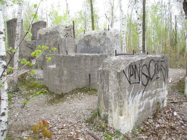
Forty metres away a five-metre concrete wall is built into the side of the cliff face. The cover photo shows the structure and another remnant of the industry that once stood here just in front of it. A close look will reveal a door which someone has painted on the wall. The picture below shows the view from on top of the wall. There is an irregular shaped pit that has been partially filled in and has a tree growing in the middle.

The Bruce Trail runs along the escarpment edge through Mount Nemo Conservation Area. There are also two loop trails to let you see more of the conservation area without wandering through areas where salamanders and other rare species could be harmed. The north loop trail is 2.6 kilometres while the south loop trail is 2.3 kilometres long. Along the escarpment face, you will notice many sections that are marked as no trespassing. This has been done to allow the cliff ecosystem to regenerate and to keep people from falling over the edge which has happened a few times.
Mount Nemo is a great place to visit any time of the year and offers great views of the fall colours.
Google Maps Link: Mount Nemo
Like us at http://www.facebook.com/hikingthegta
Follow us at http://www.hikingthegta.com

Pingback: River and Ruin Side Trail | Hiking the GTA
Pingback: The Gap | Hiking the GTA
Pingback: Mount Nemo via Bruce Trail: For the Adventurers - Going-Places Newsletter