Saturday, August 4, 2018
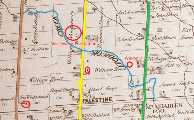
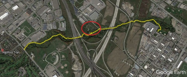
The town of Palestine was founded in 1823 by Thomas Grafton. He took the name Palestine from the Holy Land but his community never gained influence beyond a few local farms. The town built a log school house in 1842 and replaced it with a brick structure in 1863. Until 1870 church services were held in the school but a separate church building was constructed adjacent to it that year. The church was closed in 1962 and torn down in 1965. The general store was small and the town never had a post office of their own. Today the main intersection has been taken over by city sprawl and only a couple of early farm houses remain. We decided to hike along Etobicoke Creek through the farms that would have been the northern edge of Palestine but today are overrun by two multi-lane highways. Kennedy Road is brown on the map below while Heart Lake Road is yellow and Dixie Road is green. The houses featured in the story are circled and the larger circle indicates the site of the former waste water treatment plant.
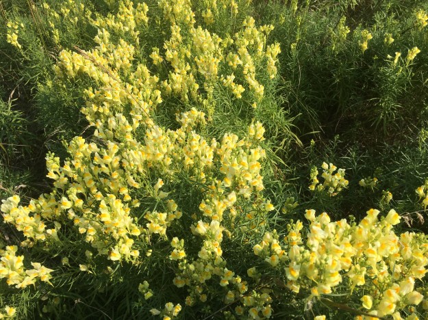
Toadflax, or butter and eggs, is not native to North America but has become naturalized. Unlike an invasive plant, this one does not take over and crowd out native plants but is found in limited clusters. Along the trail we found a comparatively large patch growing. The plant has been used in natural remedies for centuries and is proven to have diuretic properties and is effective in reducing fevers.
The Etobicoke Creek was full of life with salmon spawning in it every year when the European settlers first arrived. It wasn’t long before dams prevented fish from getting upstream and mills dumped their waste directly into the creek disturbing the local habitat. With the growth of Brampton the creek took on a new function with raw sewage being dumped into it. It became so polluted that something had to be done and so Brampton became home to the first municipal waste water treatment plant in Canada. Trunk sewer lines were built down the Credit River to the Clarkson Waste Water Treatment Plant and down Etobicoke Creek to the Lakeview Waste Water Treatment Plant making the municipal plant obsolete. It was decommissioned and removed in the early 2000’s. Today there is just a series of roads and the outline of the plant to mark the site.
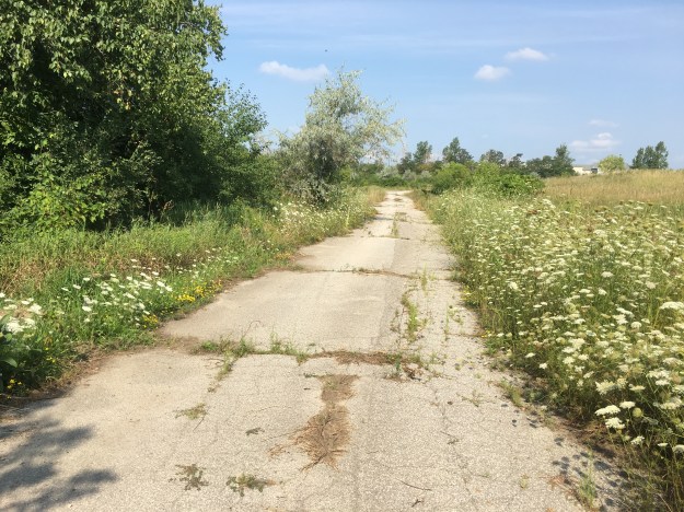
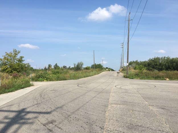
Before the opening of the 410 in 1978, Heart Lake Road was a continuous road that provided access to the water treatment plant through the driveway on the left in the picture below. Construction of the 407 in 1997 further divided the road and left it with several names. This section is now known as Westcreek Boulevard. Current Etobicoke Creek Trail improvements through the valley include the development of parking lot at the end of this piece of road to allow trail users easy access. Sketches suggest parking for about 40 vehicles.
The trail passes under the 407 as it follows the creek south.

The Etobicoke Creek Trail has entered into a Missing Links program which aims to build four sections of trail to link existing sections and complete the trail. The Sherway, North and Valleywood Links each have their own timelines but the Kennedy Valley Link is currently under construction.

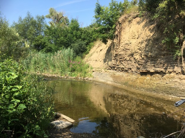
The Etobicoke Creek winds through the area revealing evidence of much greater water flow at times in the past. The ravine cliffs get taller as the creek approaches the lake with some shale banks of 30 metres being revealed downstream. This far upstream the embankments are much more modest but they have cut as deep as the shale foundations below the topsoil and sand.
The top of an old windmill stands above the treeline, obscured to those who are following the path to the south by a cluster of trees. Looking north from the site of the new bridge the crumbling farm relic is easily seen. Closer investigation reveals an open well with water inside that has no fence around it. The pump is still down there and the tower is surprisingly solid considering the crumbling condition of the vein on the top. I wonder how many children in the GTA are learning about alternate energy sources and could benefit from a working example in their local park. Why not restore it and make it safe rather than demolish it to make it safe? The story of pioneer windmills is told in greater detail in our post on The Shand Dam.
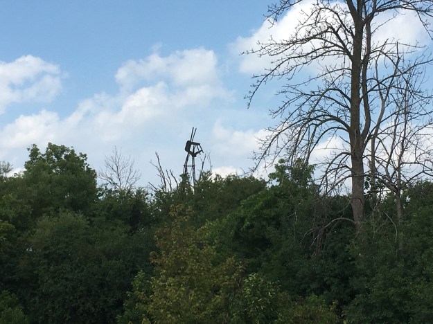
The one house remaining in Palestine is that of William Reed. His original house was replaced with this Edwardian style house around 1910. The windmill above is on the back of this property.

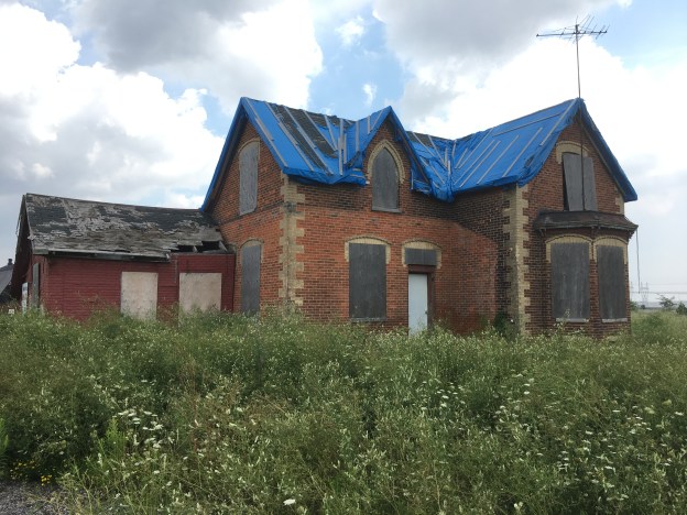
The Royal Grafton property was the original homestead in the community of Palestine. By 1877 John Wedgewood had bought the west half of the lot and built the house featured below. John was instrumental in the development of Palestine being involved in the erection of the shcool, temperance hall and church. Recently the Poweraide Centre has been built on the lot and the future of the house is unknown although attempts to protect the roof are a hopeful sign.

Japanese Beetles are native to Japan and appear to have found their way to North America in the early 1900’s, likely aboard ships. They have since spread throughout the eastern parts of The United States and Canada.

Our hike is outlined in yellow on this Google Earth capture. The remnants of the wastewater treatment plant are circled in red.
In the next few years the Etobicoke Creek Trail will be completed and hopefully they will put up interpretive signs for both Palestine and Mt. Charles, two of the ghost towns it will pass along the way.
Google Maps Link: Palestine.
Like us at http://www.facebook.com/hikingthegta
Follow us at http://www.hikingthegta.com

The trail you walked closely follows where we rode our horses during the 1970’s from Steeles and #10 over to Dixie Road. On the north bank of the Etobicoke Creek east of the first bridge over 410 and close to the waste treatment plant was a hibernaculum, which I’m sure has been demolished as 410 became wider. Just east of Kennedy on the north hill of the Etobicoke Creek is an old cemetery. It was pretty much obscured during the 1970’s.
Spent many enjoyable excursions in that valley. Saw much wildlife in the area too. Haven’t been there for a very long time, but perhaps it is long past due for a visit, though I’m sure I’ll find it all much more civilized.
Pingback: Malton – Ghost Towns of The GTA | Hiking the GTA
Pingback: Ghost Towns of Peel Region | Hiking the GTA
Unfortunately the Grafton House is gone now. Disappeared about 3 years ago.