Saturday, June 3, 2017
The community of Boston Mills was known by several names over the years including The Credit, Caslor’s Corners and Boston. It was originally founded in the 1820’s as The Credit when the River ran through the only intersection in town. By the 1850’s Hiram Caslor had built a saw, grist and carding mill and Caslor’s Corners was the common name. The post office came to town in the 1860’s and the name Boston was selected, supposedly after the song “The Long Road To Boston”.
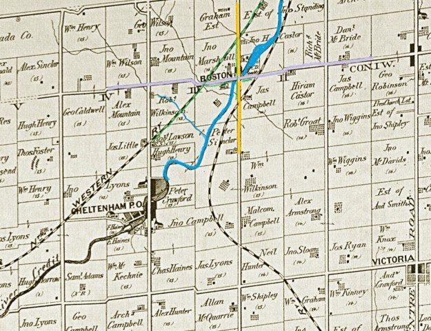
On the 1877 county atlas map below, the community of Boston Mills is shown simply as Boston. Chingaucousey Road is yellow and Boston Mills Road is light grey. The Credit River has been coloured blue as has a small tributary flowing through Robert Wilkinson’s property. The section of the Hamilton North Western Railway that we walked is coloured green as are some sections of roads around Boston Mills that we walked along.
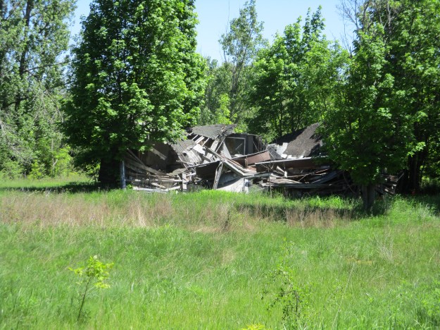
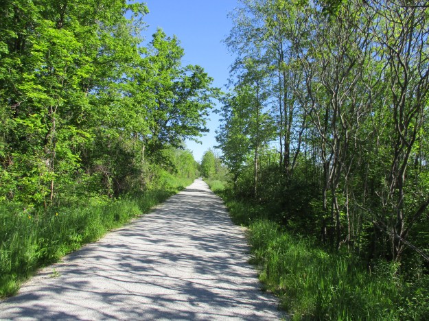
A railway line runs up either side of the Credit River. On the south side, the Credit Valley Railway made its way toward Orangeville. This section of track is still active today between Brampton and Orangeville. On the north side of the river ran the Hamilton & Northwestern Railway. Most recently the Canadian National operated it until 1987 when it was closed and the rails were removed. The right of way has been converted into the Caledon Trailway. We parked beside it on Chingaucousey Road where there is free parking. There are a number of abandoned chalets that served the Caledon Country Club from the 1960’s into the 1980’s. One of the chalets can be seen from the parking spot.
The Caledon Trailway also shares this path with the Trans Canada Trail. It is a popular spot for cyclists, dog walkers, joggers and the occasional blogger.
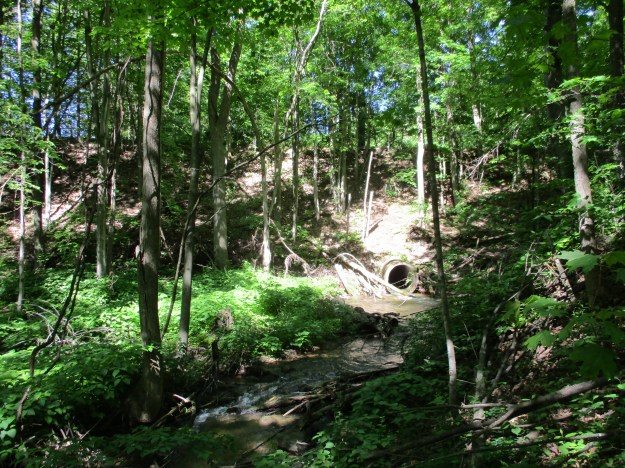
There are many side trails that run through the woods on the former Robert Wilkinson property. We explored a few of them and ended up on the tributary of the Credit River that runs through the property. The rail line runs high above the ravine floor and can be seen in the picture below as the straight line where the sky meets the ground. The concrete culvert is a later addition. The rail line originally crossed the ravine on a wooden trestle. For stability and maintenance purposes these old trestles were often filled in by dumping gravel through the tracks until a mound was formed. The culvert was added at the time that the trestle was filled in.
The corner of Chingoucousey Road (formerly second line west) and Boston Mills Road (formerly 32nd sideroad) is bisected by the Credit River. This allows one bridge to serve both roads. The modern bridge was built in 1964 and the abutments for the former alignment can still be easily seen from the bridge. The former road emerged directly in front of the gates of Boston Mills Cemetery.

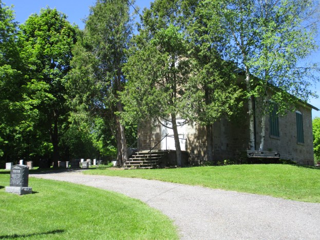
In May 1832 David Williams was struck and killed by a falling tree. They took the bark from the tree and made a coffin out of it. David was buried on a small hillside overlooking the Credit River. Other local pioneers who needed non-denominational burial grounds were laid to rest alongside Williams. In 1858 the plot of land was sold to the community by John Marshall for three grains of wheat representing the past, present and future. In 1896 the cemetery was expanded by an acre and it grew again in 1908. There is a large grave marker shaped like a cross that identifies the Sinclair plot which remained private until 1921 when the cemetery went into perpetual care. The picture below shows the gates to the cemetery. They were built in 1931 as identified by the small stone marker on the right gate post. 1823 on the left gate post records the first burial.

In 1969 the school property was sold when the school board started to amalgamate schools. From the county atlas, it appears that there was a school on the south side of Boston Mills Road in 1877. The one room stone schoolhouse was built in 1888 and is designated as Caledon SS No. 8. When it was added to the cemetery it became a mortuary to store the deceased for the winter while they await burial in the spring. The surrounding grounds have been used for burials making for the unusual combination of a schoolhouse in a graveyard. There are stories of hauntings in the cemetery and claims that there are times when lights can be seen in the old schoolhouse. Floating orbs and playing children can be seen along with an old priest among the stones in the old graveyard.

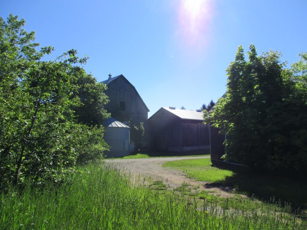
Returning to the car we passed the farm that belonged to John Marshall in the 1870’s. The cemetery is located on the corner of this property which still has a well maintained century old barn. Many types of farming no longer rely on the barn for storage and a lot of the ones in Southern Ontario have either fallen down or been removed so that the wood can be reused.
Boston Mills was considered for recognition as a cultural heritage district but much of the early town has been lost. The old schoolhouse isn’t even recognized as a heritage building as there are only three old schools in Caledon on the heritage register.
Google Maps Link: Boston Mills
Like us at http://www.facebook.com/hikingthegta
Follow us at http://www.hikingthegta.com

It is sad to see how Caledon Golf Club has deteriorated from the days when it was called Chinguacousy Country Club. The equestrian services from the late 1960’s to early 1970’s were reknown. For a while the Canadian Combined Training Team was coached by the late General ( then Colonel) Gutowski. The tracks were still used very occasionally back then.
Pingback: The Credit Valley Trail | Hiking the GTA
Pingback: Ghost Towns of Peel Region | Hiking the GTA
Pingback: One Room Schools | Hiking the GTA
Pingback: Tales from the Headstones – Who Are the Spirits of Boston Mills Cemetery? – York Durham Headwaters