Jan. 14, 2016 featuring pictures from May 13, 2015.
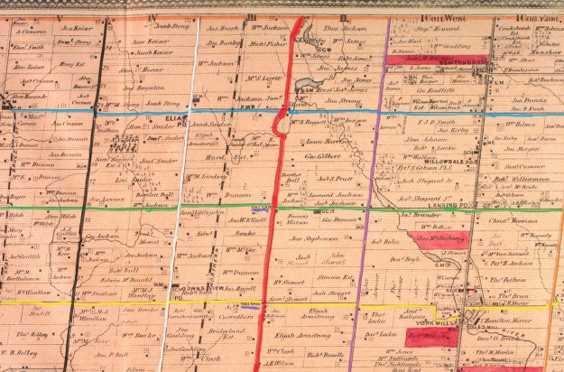
The early roads in York County were laid out in a grid by the original survey with five 200 acre lots in each box. Augustus Jones surveyed York Township in 1796 and he made Yonge Street (grey) the north-south marker. Going west (left on the map below) were 1st line west, second line west, etc. Today we call them Bathurst (purple), Dufferin (red), Keele (white), Jane (black) and so on. Eglinton was the east-west marker and known as Base Line. The side roads going north were the 5th, 10th, 15th, 20th and 25th named after the lot number they ran along. The lot numbers are shown on the map below along side of Jane St. Today we call these roads Lawrence, York Mills (yellow), Sheppard (green), Finch (blue) and Steeles (orange). This grid of roads connected all the little farming and milling communities in the township and is still imprinted on the city today. The 1877 county atlas section below has been coloured to illustrate this.
Settlers were granted 200 acres which came with several conditions. One of the mandatory tasks a pioneer faced was the clearing and maintaining of the road allowance along the edge of their property. They had to clear an area which amounted to 1 acre of land for public road allowance. They were also responsible to spend a certain amount of time working on road maintenance each year. This would include pulling stumps and filling in holes and swampy areas. The settlers had a full day’s work on the homestead and often the road repair was overlooked and people would be fined for not complying. The system led to some very messy roads where people got stuck 3 seasons of the year and bounced over ruts the other one.
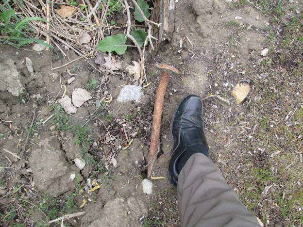
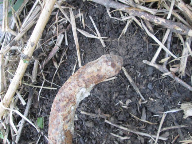
The solution was to cover some of the roads in cut boards or planks. The Gore and Vaughan Plank Road Company was established in 1855 to build a plank road along Dufferin Street. The road was to be built of local wood and various saw mills were engaged along the route to cut and prepare the planks. The picture below shows one exposed end of the plank road along with one of the steel spikes that held it together. The same spike is shown in relation to my shoe in the cover photo.
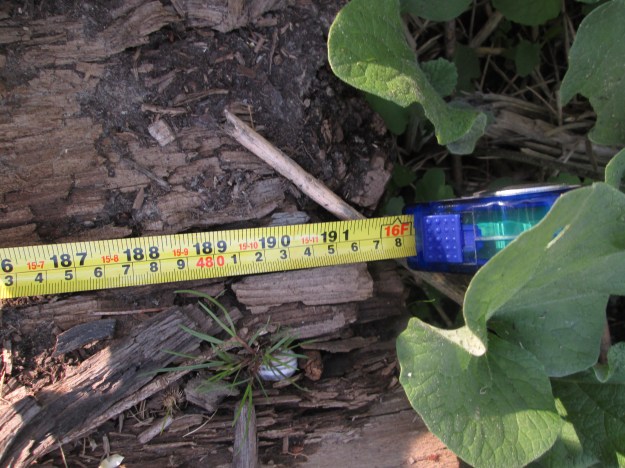
Where Dufferin street, shown in red on the map above, crossed the ravine for Dufferin Creek the descent was very steep. The solution for the pioneers was to run the road on a curve down the side of the ravine. This shows on the map just below the blue line of Finch Ave. The planks for the Gore and Vaughan Plank road were sixteen inches wide by 8 inches thick and sixteen feet long. The picture below shows the length of one of the boards.
For durability the planks were laid up and nailed through to create a roadbed that was sixteen inches thick. Planks were held together with four foot long spikes that were driven in two feet apart in opposing directions. The picture below shows the head of the spike on the left and the point of the spike on the right. The tape measure is laying on the seam between two planks.

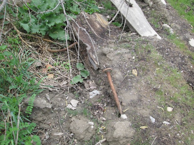
In this spot there is almost 2 feet of spike sticking out of the plank where the exposed boards have rotted away.
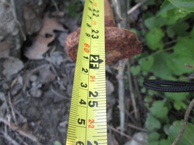
The spikes used in the plank road construction have a 3 inch diameter head on them and were over 4 feet in length.

The body of the spike is 1 inch in diameter.
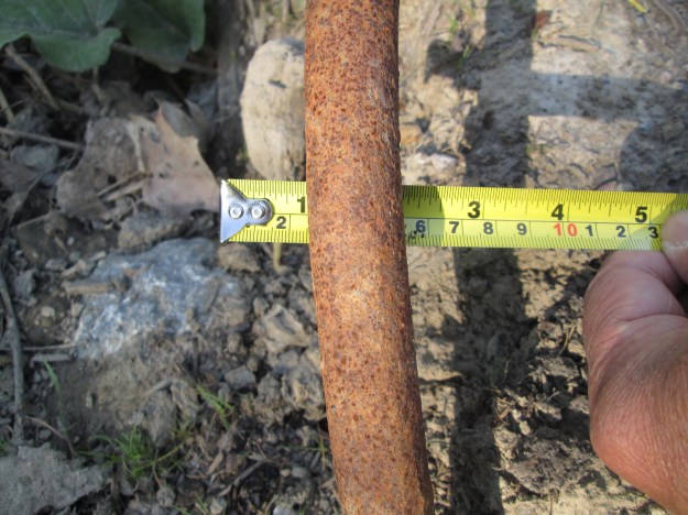
The picture below shows the business end of the spike.
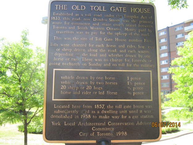
The plank road was expensive to maintain as new wood was continually replacing worn and rotten boards. The solution was to assess a toll for the use of the road. Toll stations were set up at various places along the plank road. On the map above there are two. One is at Finch (yellow) and the other at Sheppard (green). They are marked on the map and underlined in blue. Yonge Street was also planked with a toll station at Hoggs Hollow. The picture below was taken on Dundas Street near Lambton Mills and shows a representative toll charged for using a maintained road.
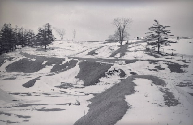
Times changed and crushed gravel and asphalt replaced plank roads. Dufferin was paved and where it crossed Dufferin Creek on a long curve it was straightened out. The curved section in the ravine was left to rot or to be buried by flooding. When the trunk sewer along Dufferin Creek required repair work in 2014 a portion of the plank road was exposed again. Hiking the GTA found these remains and gave a brief description in Dufferin Creek in May 2015. This post allows for greater detail and more pictures to be presented of this 160 year old part of our transportation heritage. The archive photo below from 1954 shows the old roadbed as seen from the modern Dufferin Street.
Google maps link:
https://www.google.ca/maps/@43.7658222,-79.4749897,14z
Like us at http://www.facebook.com/hikingthegta

Neat bit of history. Thanks!
Pingback: Dufferin Creek | Hiking the GTA
Pingback: Garbage Park – Clean Toronto Together 2016 | Hiking the GTA
Pingback: Rice Lake’s Sunken Railway | Hiking the GTA
Pingback: Hiking the GTA #200 – Greatest Treks 2 | Hiking the GTA
Pingback: Toronto’s Abandoned Roads | Hiking the GTA
Pingback: Ringwood – Ghost Towns of the GTA | Hiking the GTA
I don’t think your numbering of the concession and sideroads is correct.
Take a look at King township, which has pretty much the same survey as Toronto north of Eglinton. King still uses numbers for many roads.
In King, sideroads were numbered sequentially (14,15,16, etc) not by lot number.
You can see Markham also used this system (14th,15th, 19th avenues survive).
{the “number by lot” system you suggest was very common in Ontario, just not in York}
Also Bathurst probably wasn’t “1st line” it was probably “2nd Concession Road”.
Yonge was counted as “one”, so Bathurst was “two”.
You can check this by finding the 7th concession road in King and working backwards.
{the “line number” system you suggest was very common in Ontario, just not in York}
The line numbering originally came from “North Toronto” by Don Ritchie which I got out of the library. Surveys were often completed by different people and occasionally the townships didn’t line up leaving jogs in the roads and at intersections. A quick google produced a similar description of the numbering ssytem.
Dufferin Street started out simply as the second line west of Yonge Street, York Township (Bathurst being the first line west of Yonge), and known simply as the Side Line. It was formally named in 1876, for the then Governor-General of Canada, Frederick Hamilton Temple Blackwood, known as Lord Dufferin. http://spacing.ca/toronto/2013/08/05/history-dufferin-street/
Pingback: Downsview Park | Hiking the GTA
Pingback: Downsview – Ghost Towns of the GTA | Hiking the GTA
Pingback: West Don Parkland | Hiking the GTA
Pingback: Claireville – Ghost Towns of the GTA | Hiking the GTA
Pingback: Elm Bank | Hiking the GTA
Pingback: The Tollkeeper | Hiking the GTA
Pingback: Historic Tollkeeper’s House is one of Toronto’s oldest homes – Canadian Military History
Pingback: Fairbank – Ghost Towns of the GTA | Hiking the GTA
Pingback: Hambly House – Nobleton | Hiking the GTA