July 26, 2016
On March 6, 1834 the Cobourg Rail Road Company was chartered to build a railway from Cobourg to Peterborough crossing Rice Lake. This was one of the first two Railroad charters issued in Canada and it came just a few years after the first railroads were built in the UK. In the summer of 1996 I set out to investigate the remains of the railway.
The concept had begun in 1831 when several businessmen from Cobourg contracted the Provincial Land Surveyor, F. P. Rubidge, to survey possible routes for a railway from Cobourg to Rice Lake. The following year a map showing a proposed route following several valleys ran to the community of Sully (Harwood). Money didn’t show up but the Rebellion of 1837 did and the plan got forgotten until 1846. This is when Samuel Gore revived the idea as the Cobourg and Rice Lake Plank Road and Ferry Company. Gore intended to bring lumber and other natural resources to the Cobourg harbour for shipping, thus creating a thriving port community. His plank road didn’t survive past the first couple of winters but pictures of a similar plank road called The Gore and Vaughan Plank Road were published in a previous article.
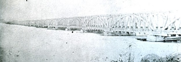
In 1852 a new plan was chartered for the Cobourg and Peterborough Railway. The official sod turning for construction was performed by the wife of the Cobourg mayor on Feb. 7, 1853. During that first year farmers along the way contributed wood from the forests and labour from their horse teams. The old plank road bed was used but in 1854 a labour shortage was caused by the Crimean War and labour rates rose to $1.00 for a 12 hour day. German labour was brought in and tragically, 14 of them perished that year to cholera. When completed at the end of 1854 the trestle was nearly 5 kilometers long making it the longest railway bridge in North America at the time. The archive photo below shows the trestle set on piles that had been driven into the lake bed. Each truss was 24 meters long and it took 33 of them to make the crossing. In the deepest part of the lake a 36 metre swing bridge was installed to allow navigation from one end of the lake to the other.
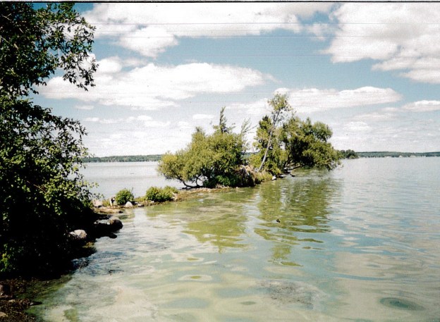
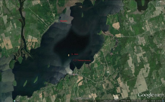
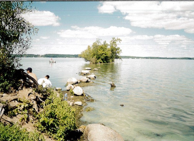
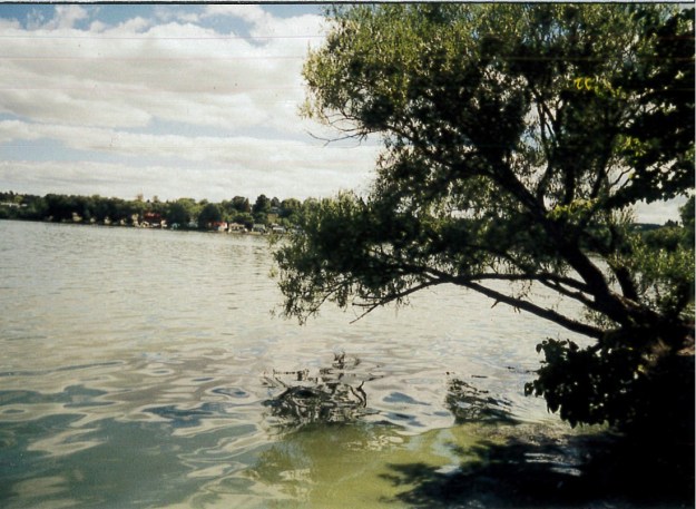
The view below from Google Earth shows Harwood and the railway causeway reaching out into the lake. Starting in 1855 John Fowler took over as chief engineer and he began to fill in the cribs below the trusses in an effort to secure them from the winter’s damage. The trestle from Harwood to Tic Island was filled in and this can still be seen from aerial photography. The railway manager, D’Arcy Boulton continually defended the railway claiming that Samuel Zimmerman hadn’t properly completed the line when he turned it over and started work on a rival line out of Port Hope. Boulton suggested that a half a million cubic yards of fill could be dumped into the remaining open cribs and that would solve the trestle problem permanently. The cover photo shows the causeway as it stretches away from shore as it appeared in 1996. It is one of four pictures from that trip that have been scanned and added to this article.
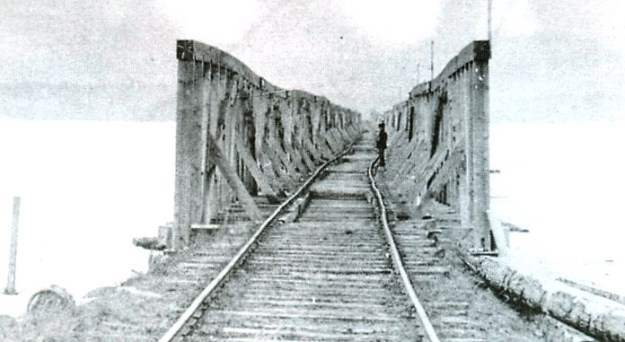
The first train from Cobourg to Peterborough ran the 45.8 kilometer track for free on December 29, 1854 to show off the new railway. Celebrations were a little premature as ice damaged the trestle just three days later on January 1, 1855 and the line was shut down until it could be repaired in the spring. The seventeen truss sections that ran south between the draw bridge and Tic Island were shoved hard enough that the span on the abutment on the island was displaced by four feet. Ice damaged the bridge again in the winters of 1856-57, 1859-60 and fatally damaged it in 1860-61. Parts of the trestle collapsed and some claim that a rival railway had removed some of the bolts from the truss sections. The trestle was permanently closed and the railway from Hiawatha to Peterborough abandoned. The archive photo below shows damage to the trestle following the shifting of the ice. Notice how the rail is twisted near the person standing on the bridge.
Finally I had reached the end of the causeway and found a couple of fishermen trying their luck. The causeway stretches off toward Tic Island which is hidden by the cluster of trees that have found a home on the rocks.
The line was sold in 1866 to the Marmora Iron Works for $100,000 but the citizens of Cobourg had invested ten times that much in the railway. The company planned to bring iron from a mine on Crowe Lake to Trent Bridge at the northern end of Rice Lake by rail. From there a barge would move the ore to Harwood for shipping on the old railway to Cobourg. The venture went well until 1873 when the economy went bad and the iron market collapsed. This led to the closure of the mine and by 1877 the company was again bankrupt. Parts of the rail line were absorbed into the Grant Trunk Railway in 1893. The picture below shows the rail end in Harwood at Rice Lake around 1865 with a barge tied up at dockside.

Hiking to the end of the causeway involves a lot of climbing over tree roots and around rocks. The picture below shows the width of the causeway as it stretches from the shoreline. The water level in Rice Lake was raised by about eight feet in the 1920’s when the Trent Severn Waterway was constructed. The rail berm I was hiking on was originally built 4 feet above the high water mark.
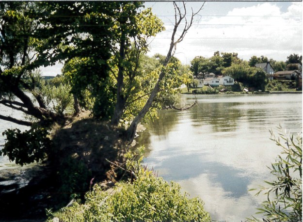
In 1996 it was possible to make your way a considerable distance from the shore along the old causeway. This picture is taken from the end looking back to the shore.
It’s now been 156 years since a train made the crossing but the remains of the Cobourg & Peterborough Railway still have their story to tell.
Google Maps link: Harwood
Like us at http://www.facebook.com/hikingthegta
Follow us at http://www.hikingthegta.com

Awesome story, follow your posts regularly.
You can walk from Harwood dock to tick island if you follow the correct path
What did the First Nations people – Algonquins I believe, have to say about this project since they have protested the loss of their traditional wold rice harvesting to other projects harmful to this traditional practice in the past? I’m quite sure that modern Algonquin people are still harvesting wild rice the way they have done for perhaps a millennium.
Hi Murray. We are Ojibwe in Hiawatha First Nation. We are all one with Curve Lake and Alderville at one time before forced onto reservations. The loss of our rice is very sad.
There is much more to this very interesting story: this is one of many railroads that were built by private “entrepreneurs” with gov’t money. They got rich building railroads that had no chance of making a profit, but somehow were good politics. My ancestors were among the entrepreneurs, and the worst of it is that they didn’t leave me a cent! A causeway across any lake is usually an environmental disaster, and we did get some decent biking trails out of it.
Murray, almost all the wild rice was wiped out in the early 1800s when the water level was raised to make the lake navigable. At the time, it was all above board with the Hiawatha First Nation signing a treaty (even though few could speak or read English). There is still a bit of wild rice in some shallow bays, but not much. I was told that the canoe was invented on Rice Lake and was ideal of collecting the wild rice, but I’ve never had that confirmed.
Hi Johny:
Thank you for your informative reply. You are so right; I was thinking of the present day Ardoch Algonquins who live in Lanark County. I was an ally (along with many settler folk in Lanark County & Perth) with them for some weeks in 2007/2008 with Christian Peacemaker Teams when at least a couple of Algonquin bands blockaded a uranium exploration company’s work at the Robertsville Mine on Robertsville Road near Sharbot Lake, north of hwy #7. There are written stories about the Algonquins resisting a company that wanted to take over and commercialize the wild rice harvest. This was some years ago and I don’t have a date. Apparently if memory serves, the Algonquins won the struggle. So it is not Rice Lake I am thinking of but one or more of the many small lakes in the Sharbot Lake area. I assume that Rice Lake gets its name from Wild Rice which once grew there. My wife and two of my boys camped there on our way to Ottawa in 1987. I was fascinated by the ancient Indian mounds seen there. Our family has also camped at Bon Echo Provincial Park over the years including last year. My sins and I have also done canoe trips in Algonquin Park, latest was end of June, beginning of July at Achray Lake area with youngest son & his family (wife & 3 kids – age 11 to 6) from Ottawa. I live with my wife on the Danforth in Toronto.
ive seen folk harvest rice in canoes its pretty awsome. then a huge copper pot on shore to heat to husk the shells i think. was a great watch though
have you noticed that there are fewer stones on the railway bed?
Enjoyed post on Cobourg-Peterboro Rice Lake rail bridge. Have explored most of the old RR burn between Cobourg and Harwood. Cobourg’s rival the Port Hope, Lindsay & Beaverton RR ran successfully until mid 1950’s (under different names) by avoiding Rice Lake.
Ranger.
Pingback: Hiking the GTA #200 – Greatest Treks 2 | Hiking the GTA
I walked from Harwood dock to tick island because of the old railroad
Pingback: Greatest Treks 3 | Hiking the GTA
Pingback: Back Tracks – 5 Years of Trails | Hiking the GTA
Pingback: Midland Railway | Hiking the GTA
My Grandparents lived on a farm in Roseneath Ont overlooking Rice Lake and told me at nite they could see the lites of the train crossing Rice Lake
“Thank you” to each contributor with all-very-interesting and appreciated postings.
The photo of the damaged bridge shows that the line was built to “Provincial” gauge of 5′-6″ between the rails.
Pingback: Back Tracks – 8 Years of Trails | Hiking the GTA
My husband’s grandfather purchased property in Harwood in 1923 and we still have family there. Our property was actually the site of an old mill on the lake… ..thanks for the great memories
Hello Gai,
When I read this article, that was reposted by a friend of mine, I was hoping that one of the family would see it and comment. I could not remember what remained in the shallows by the end of the property. Thank you for clearing that up for me.
I hope that all is well with you and your family. I would love to hear from you. We drive to Harwood passed the “field” at least once a summer. So many memories. All the best to you. Nancy Aitken