Saturday, November 24, 2018
Until 1954 Old Finch Avenue crossed The Rouge River on a steel truss bridge. Hurricane Hazel demolished the bridge on October 15, 1954 and shifted the cut stone abutments to the point where they were no longer usable. The quick solution was to install a temporary bailey bridge which we decided to visit.
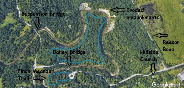
The river has cut steep embankments through this area of sand and gravel that can be seen from Google Earth. The capture below is taken from there. The blue line roughly shows the areas we hiked. There is parking for The Meander Trail at the turnaround on Old Finch Avenue beside the bailey bridge.
The bailey bridge is 130 feet long and was constructed by the 2nd Field Engineer Regiment in just 3 days. The Field Engineer Regiment dates back to January 14, 1876 when the unit was created. They are based in Toronto and continue to parade at the Denison Armoury at Downsview Park every Friday night. Following the hurricane, which claimed 81 lives, there was a need to rapidly repair infrastructure to keep people from being isolated from food and medical needs.

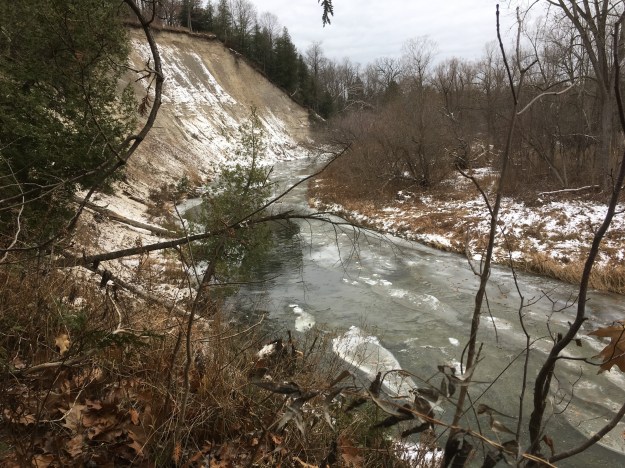
After crossing the bridge we made our way into the bush on a worn trail that turned toward the river pretty quickly. The picture below shows the river looking upstream toward the only suspension bridge in Toronto which is around the next bend on Sewell’s Road.
It was a day for finding dead animals and we were surprised to find a dead deer that looked like it had been well scavenged. It turns out that even small birds that eat suet at your feeder will pick at a deer carcass. Within a couple of feet of each other we also found a dead crayfish and a dead salmon. The salmon must have been one of the last of the fall spawning run. It too has been well scavenged as nature feeds nature and nothing is left to waste.

At the end of the last ice age, about 12,000 years ago, all of Toronto’s ravines were full of rushing melt water from the retreating glacier. Ice had been a kilometre thick over the area and our extensive system of ravines was created as it melted. Ravines and embankments were eroded that are way out of scale for the size of rivers that currently flow through them. Where The Rouge River turned corners around this hogs back it carved the large embankments that can be seen in the Google Earth capture above.

After we had followed the river around we arrived back at the bailey bridge.
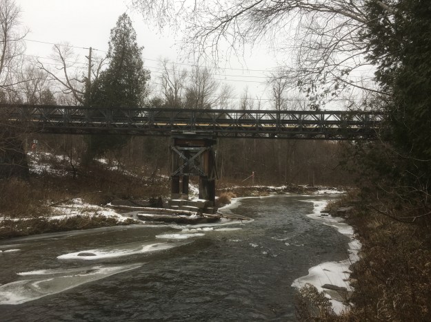
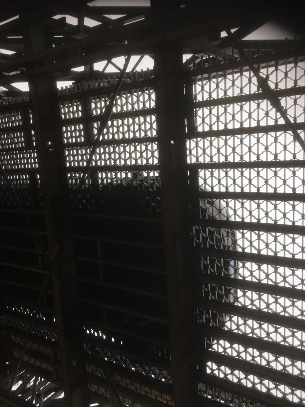
It is an odd feeling standing below the bridge as a car rattles past overhead. The bridge decking is in good condition and looks like it has been replaced at some point.
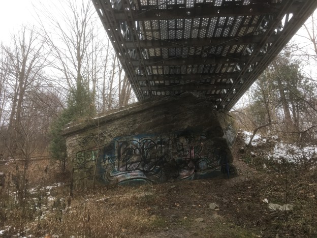
This picture, as well as the cover photo, show the extent that the abutments were thrown out of alignment by the hurricane. Bridges over the rivers in Ontario have gone through several phases with the early wooden ones lasting for only an average of ten years. Later steel truss bridges were built on cut stone abutments which were themselves often replaced with concrete abutments and new bridges early in the twentieth century. Old Finch Road wasn’t so old when the cut stone abutments were placed here but traffic and maintenance costs never mandated a new bridge prior to 1954.
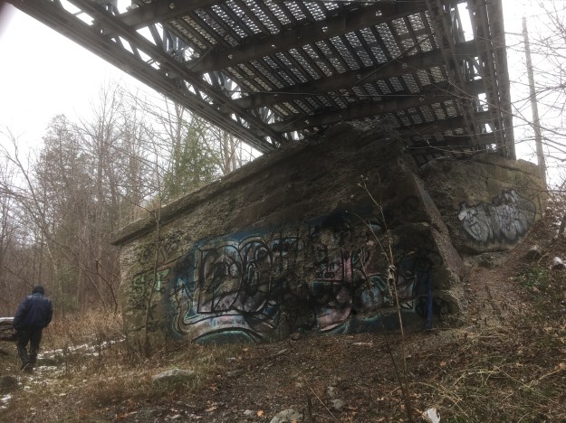
Looking from the inside of the abutment you can see why the military decided the abandon the stonework and install a temporary bailey bridge. The field engineers who built it likely never expected it to last more than about 20 years, let alone nearly 65.

Before returning to the car we made the quick walk around a short trail that is part of Rouge National Urban Park. The Finch Meander Trail runs for 250 metres and lets you have a closer look at the river near the bailey bridge. From here we went to the site of Hillside Church and cemetery on Old Finch Road. The church opened on November 18, 1877 as a part of the Scarborough circuit of the Methodist Church. This meant that it didn’t have a permanent minister at that time and one would come for Sunday services. The property was donated in trust to several local men for the purpose of the church and cemetery. Among them was John Sewell (Sewells Road with the suspension bridge), Peter Reesor (Reesor’s Road) and George and James Pearse (Toronto Zoo property). In 1925 they became part of the Mount Zion United Church and today the building is still the same inside and out as when it was first opened.

The church cemetery is the final resting place for many of the early settlers from the community. This includes members of the Pearse family who owned the house that is now the nearby visitor centre at Rouge National Urban Park. You can read more about them and see the house by clicking here. It is said that this cemetery is haunted and that the ghost of a girl murdered on her birthday still haunts the bailey bridge.

The community of Hillside has become a vanished village where a few homes and the school remain along with the church. Perhaps we’ll return one day for a Ghost Towns of the GTA feature.
Google Maps Link: Old Finch Avenue
Like us at http://www.facebook.com/hikingthegta
Follow us at http://www.hikingthegta.com

Are their any signs yet of cliff swallow or kingfisher nesting on the eroded banks?
Yes, there are rows of nesting holes.
I was a bridesmaid in a wedding the night of Hurricane Hazel & word got around that the bridge had been washed out & I can well remember driving out to have a look & then going back to see the new bridge after it was built. Old memories for sure. Thanks for all the pictures & information. I grew up in the Birchmount/Danforth Road area & now live in Barrie so love looking at Scarborough Looking Back.
Keep up the great work! I can’t wait to find some time to read through all your posts!
Thank you, Daniel!
Very interesting!
Our Great Gramma Ormerod, Gramma Jenkins are buried at Hillside
Pingback: Haunted | Hiking the GTA
Pingback: Hurricane Hazel – Raymore Drive | Hiking the GTA