
Monday September 12, 2016
Updated August 19, 2021
Both the road and lighthouse are closed indefinitely. Please enjoy the place as it was in 2016 as documented below.
The waters of Georgian Bay hide the hulls of countless shipwrecks, at least nine of which lay near Cabot Head. During the 1850’s shipping traffic on Georgian Bay was increasing and on Dec. 11, 1856 the first known shipwreck in the area of Cabot Head was recorded. It was a small schooner owned by George Newcombe of Owen Sound. In 1863 a 10-ton schooner Pioneer was sunk in the entrance to Wingfield Basin. Three more schooners were lost Son & Heir (1869), Shannon (1884) and John R. Bentley (1886). A steamer named Kincardine was lost in 1892 and finally in 1895 the Government decided to take action. They called for tenders to build a lighthouse and fog horn station at Cabot Head.
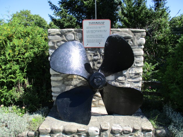
Being on holidays I was Hiking the GTA (Giant Toronto Area) which this day included the Giant’s Rib known as the Niagara Escarpment on the Bruce Peninsula. On my way home from Tobermory I decided to take a side trip to see the Cabot Head Lighthouse. The road through Dyers Bay passes by this cairn with a large steel propeller on it. It was found in Wingfield Basin in 1986 and rescued a year later. No one knows what ship this came off of but it was manufactured in Saginaw Michigan.
In 1963 a road was built from Dyers Bay to the Cabot Head Lighthouse. Prior to that all supplies were either brought in by boat or carried by trail from Gillies Lake. The road is about 9 kilometers long and hugs the shoreline for a very scenic drive. You’ll have time to enjoy the view as you creep along trying to avoid the giant potholes. The worst ones are hiding in the places where trees shelter the road. These shady spots don’t dry out making them more prone to potholes. As an added bonus the shade makes the holes harder to see, so be careful.

The lighthouse went into operation on May 18, 1896 with William Campbell as the first lighthouse keeper. The original lighthouse as well as the automated light tower can be seen in the cover photo.
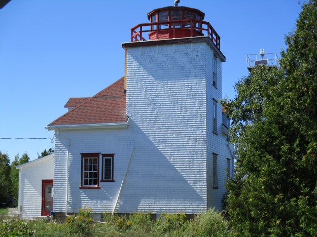
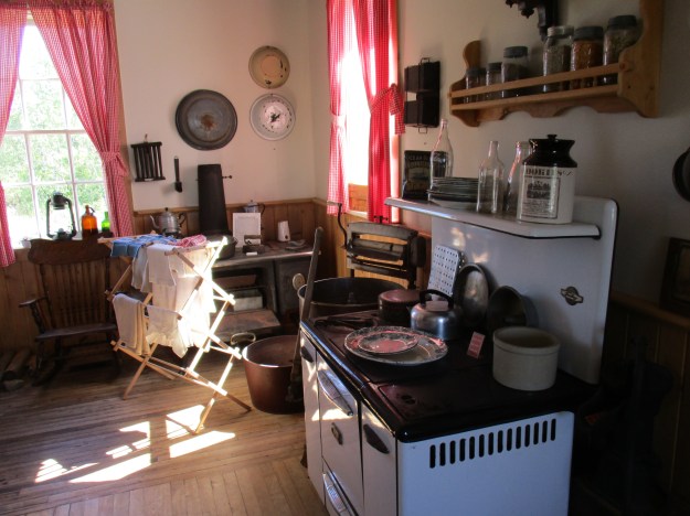
The lighthouse incorporated a house for the keeper to live in. On the main floor there was a kitchen space with bedrooms and closets on the second floor. In 1958 a cottage was built for the keeper to live in. Being a lighthouse keeper was a well paid and prestigious job. It involved the maintenance of increasingly complex technology and normally provided secure employment in spite of the hardships that went with the isolation. Cabot Head lighthouse had seven different keepers in the century between 1896 and 1987 when the job was made obsolete.
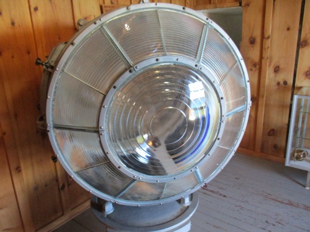
Atop the lighthouse keeper’s residence, 80 feet above the lake, sat a red octagonal lantern. In the beginning the lantern was lit with flat wick kerosene lamps. These were reflected using parabolic metal reflectors called catoptric. The light from these could be seen 16 miles out into the lake in clear weather. Kerosene lamps and later electric light changed how the job was conducted. In 1968 the automated tower seen in the cover photo was added and the light pictured below was installed. It flashed once every 15 seconds to warn sailors of the shoreline. It was later replaced and then the automated tower was converted to solar power in 2005. The original light from the automated tower is stored on the third floor of the lighthouse tower.
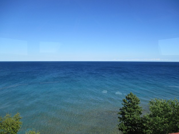
From the top of the lighthouse the view across the lake seams quiet enough. Looking out the depth ranges to about 20 meters for the first two kilometers. Then it suddenly drops to 90 meters, which is equivalent to the height of the bluffs above the shore.
When the lighthouse was built they also constructed a foghorn to alert ships during foggy weather. Also built in 1896, it used a steam driven horn for the first ten years. A Toronto company invented the Diaphone in 1903 and one was installed at Cape Head in about 1906 or 1907 following a fire to the fog horn building. This device created a noise using compressed air and a cylinder that could be heard for ten miles. In 1971 the fog horn was replaced with a electronic signal coming from the new tower. The foundations are all that remain of the fog horn station.

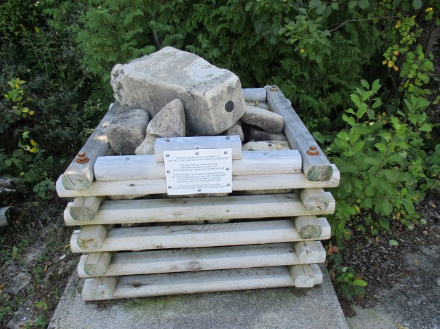
According to the Canada Shipping Act, 2001, every vessel in Canadian waters must carry nautical maps or charts issued by the Canadian Hydrographic Service (CHS). In 1964 they mapped this part of Georgian Bay under the guidance of Captain A. J. Kerr. They set up rock posts as markers to locate features during their survey. This one was found lying on its side about 150 meters south of Cabot Head and was moved to the fog horn foundations in 2012 with the permission of CHS. Today hydrographic features are located using GPS information.
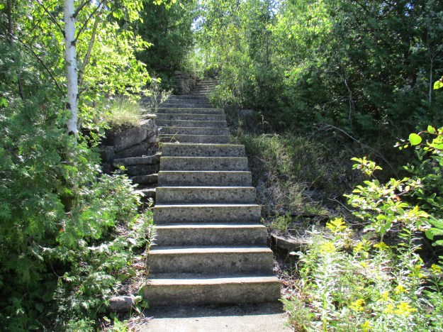
A set of concrete steps leads from the lighthouse to the fog horn base.
A new display at the lighthouse commemorates the native people who originally found this area to be ideal for fishing. A twenty minute walk from the lighthouse brings you to Wingfield Basin which has a small mouth opening onto a protected 1/4 mile diameter basin where small boats can find refuge during storms. A commercial fishery was established here in 1900 but over-fishing and the introduction of lamprey eels destroyed the fishing and it was closed. Today the main fish that are caught commercially are splake and whitefish.

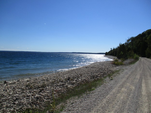
As you drive back out to Dyers Bay road take note of the change in the rocks along the shore line. An extensive stretch is covered with boulders that have been rounded over the years by being pounded together. There is an odd section that contains flat pieces of shale instead of the rounded boulders. Adjacent to this place the limestone of the escarpment face is exposed in the only place where it comes close to the shore.
The lighthouse is manned by volunteers who have worked hard to turn it into a museum. Maintaining the building and grounds costs money and is solely funded by donations. This is an historic landmark that is well worth the drive and the donation!
Google Maps Link: Cabot Head Lighthouse
Like us at http://www.facebook.com/hikingthegta
Follow us at http://www.hikingthegta.com

The Cabot Head lighthouse and access road, currently, are closed to visitors!
Great article!
Pingback: Gone… But Not Forgotten | Hiking the GTA