Saturday, March 10, 2018
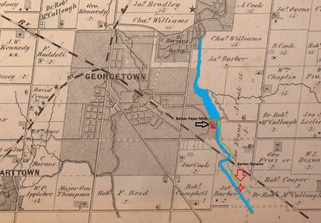
The Credit Valley Footpath is a 5.3 kilometre side trail that is part of the larger Bruce Trail system. It runs along the side of the Credit River through Georgetown providing access between two early industrial sites of the community. At the time of the historical atlas in 1877 the paper mills existed and their mill pond was drawn into the atlas. The mills themselves are not identified as they are part of the larger urban area of Georgetown. The Dynamo was yet to be constructed and is shown with a red star on the map below. We followed the green trail on the map which marks the Credit Valley Footpath.
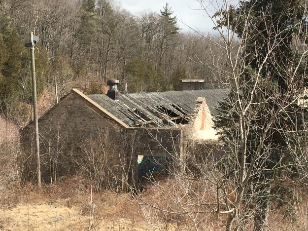
Parking for the trail can be found along Maple Avenue near River Street. This will place you beside the historic Barber Paper Mills. Their history is told in detail in an earlier blog post which can be found here. The buildings were listed as heritage sites in 2008 but over the years there has been no real effort to preserve them. The roofs are caving in and the walls are crumbling. A recent proposal to restore and re-purpose the buildings has fallen through and the National Trust for Canada has listed the buildings as among the most endangered heritage sites in the country.

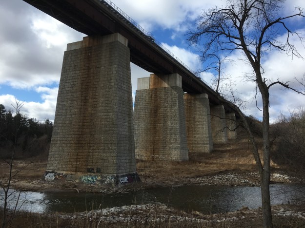
The footpath passes under a newer railway bridge about a kilometre downstream. The original bridge was nicknamed The Iron Bridge and was built in 1855 for the Grand Trunk Railway. The concrete piers on the modern bridge were built in 2010 and were dressed to look like cut stone blocks. The very last pier on the west end is actually cut stone blocks and dates to the the second bridge across the valley.
The Credit Valley Footpath through this section makes a couple of 40-metre climbs up the side the the Credit River Valley and fortunately, there has been a few steps put in to help. Sections of this trail should be considered as difficult and should be walked with the assistance of a walking stick.

Traveller’s Joy, also known as Old Man’s Beard, is a member of the buttercup family. The feathered seed pods have survived the winter on the vine and will be distributed in the spring to spread the plant to new sites. The flowers attract bees and other pollinators and are a food source for certain moths. Traditional medicine has made use of the plant for its anti-inflammatory properties.

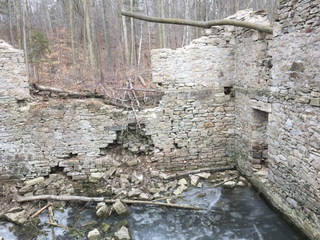
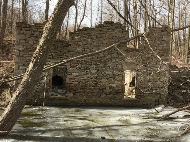
The Barber Dynamo was built to provide electric power to the paper mills. It is located a couple of kilometres downstream and was the first remote generation of electrical power for industrial uses in North America. When we visited the Dynamo in 2015 there were a number of trees that had been partially chewed through by local beaver. They were in danger of falling on the Dynamo and further demolishing it. Hiking the GTA brought the situation to the attention of the Credit Valley Conservation Authority who sent people in to cut the trees. All but one of them was successfully dropped away from the building. It can be seen leaning through a second story window frame.
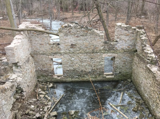
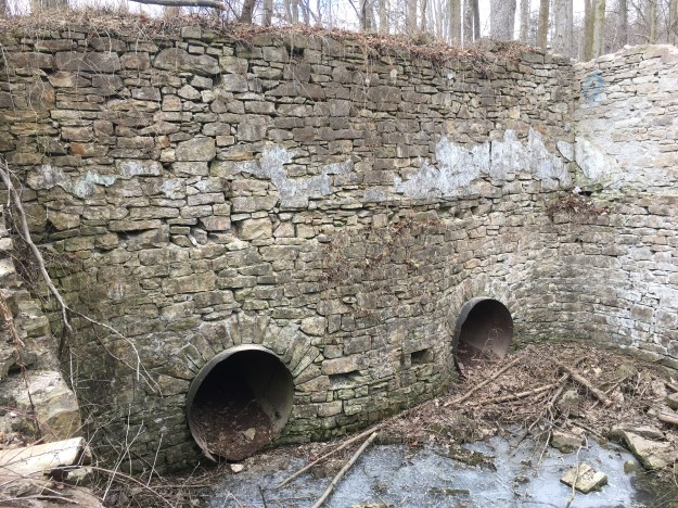
Water was fed into the Dynamo through a large pipe called a penstock. It split in two with the water turning two turbines that were suspended from the second floor. A line can be seen along the wall that marks the location of the former floor. The cover photo shows the inside of the north wall which has started to crumble and is in danger of collapse. Efforts are being made to have the site declared as historically significant which may allow the Credit Valley Conservation Authority to gain the funding needed to restore the wall to prevent further deterioration of the structure.
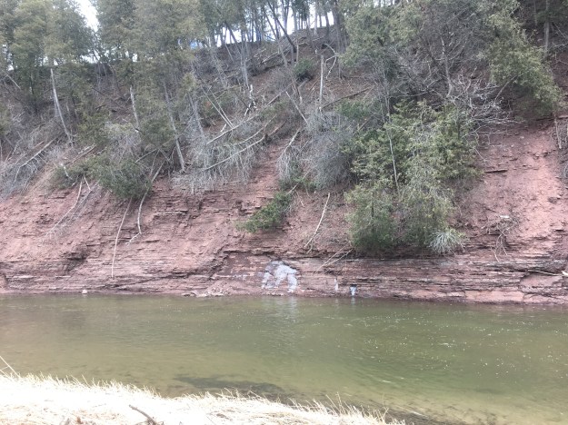
Just beyond the Dynamo the river cuts through a red shale embankment. This Queenston Shale is the same layer that forms the base of the Niagara Escarpment. The exposed section near Cheltenham has become a major attraction and is set to re-open with a new boardwalk in the near future. The erosion along this section of The Credit River has brought many of the trees tumbling down the embankment.
As you walk back toward the Dynamo you can see the penstock through the ground floor window. There are two windows just below the current water level that returned the water to the tail race after it had turned the turbines to run the generators.
As you arrive back at the Barber Paper Mills you can see the roof on the building that housed the main paper rolling equipment is caving in. The tool shop in the foreground has lost its roof a long time ago.
This is a good hike for those interested in the local history as well as a few challenging climbs.
Links to the more detailed stories: The Barber Paper Mills and The Barber Dynamo
Google Maps Link: Credit Valley Footpath
Like us at http://www.facebook.com/hikingthegta
Follow us at http://www.hikingthegta.com

The original c.1855 piers for the iron bridge are still there. Metrolinx/CN just widened them to accommodate a third rail, then did the rendering for cosmetic purposes.
Civil engineers, Francis and Walter Shanly, began by building a wooden trestle first. It quickly became obvious that the span across the valley was too wide and needed a sturdier structure. The gentleman charged with dismantling the wooden trestle just happens to be the same man who built the Exchange Hotel adjacent to Georgetown’s c.1856 GO Station. Pictures taken in the hotel attic clearly show that the timbers were put to good use!
Pingback: Streetsville – Timothy Street | Hiking the GTA
Pingback: The Credit River – Georgetown | Hiking the GTA
Pingback: Timothy Street – Pioneers of the GTA | Hiking the GTA