
Saturday, June 27, 2020
Altona Forest in Pickering is known to have a wide variety of wildlife but when we visited in August of 2018 we found the park to be deteriorating badly. Garbage abounded in the parking lot, the trails were overgrown and most of the boardwalks had become broken and dangerous. Laceys Pond was impassable because the water level was up from beaver activity and the boardwalk was broken in several places. I sent the Toronto Region Conservation Authority a link to the blog we published with the pictures of the park’s conditions. The TRCA responded that they had already purchased materials to repair the boardwalk through Lacey’s Pond but that some sections of the trail in the north woods might be closed permanently. Nearly two years later we decided to return to see how things had developed.
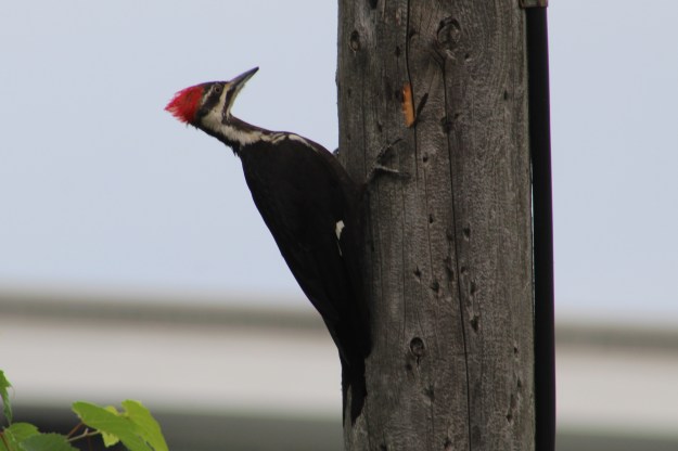
It’s a good sign when you see interesting wildlife the moment you park the car. A pileated woodpecker was making its way around the telephone pole a few feet away. The easiest distinction between the male and females of this, the largest woodpecker native to Ontario, is the red stripe on the cheek. It looks like a red mustache on the males, which identifies this bird as a female.
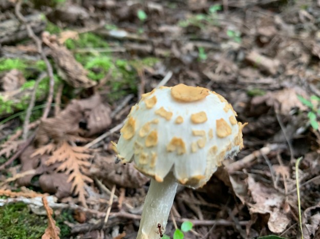
The mushroom shown below was one of a couple dozen that were growing in a rough circle around the base of a large tree. There are several varieties of mushrooms that have scales on them and most of these are poisonous. Any time the exact identification of a specific mushroom can’t be made it is best to leave it alone and not even touch it.
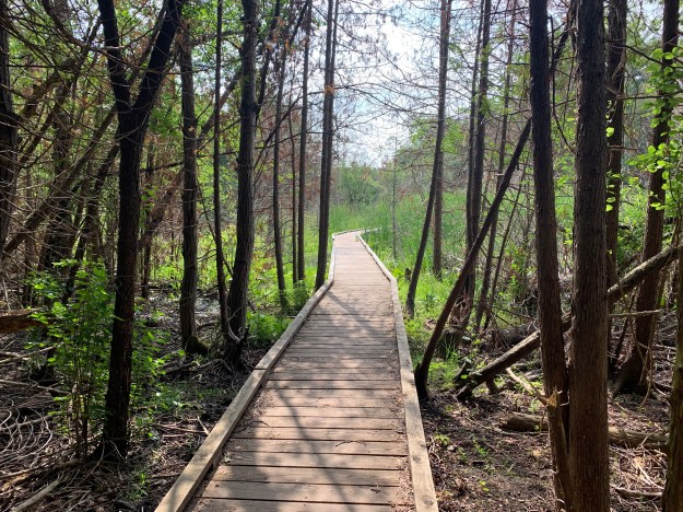
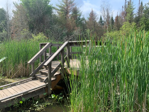
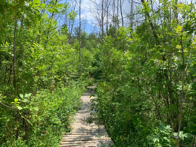
When we came to the trail that leads toward the pond in the forest we found the newly repaired section of boardwalk. They’ve done a nice job of weaving the trail among the trees.
Lacey’s Pond refers to a pond that used to exist on the property when it was a farm belonging to the Lacey family. At that time it was much larger than today and encompassed some of the area where nearby houses stand today. When developers bought the land they drained the pond and built houses where they could. Part of the land was still unsuitable for houses and was left fallow until the TRCA bought it in 1995. They made efforts to re-establish the pond by building a retaining berm. The pond refilled to about one third the original size. Further flooding has been caused by beaver who moved into the new pond. There is no evidence of recent beaver activity as all the stumps appear to have been chewed some time ago. There is still a series of trails that have been made through the wetlands and some of them had the mud recently stirred up in them.
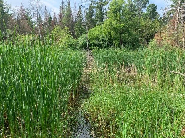
Lacey’s Pond has an observation deck where you can watch the pond during some seasons. At the moment the bull rushes are growing tall enough to obscure most of the water in the pond.
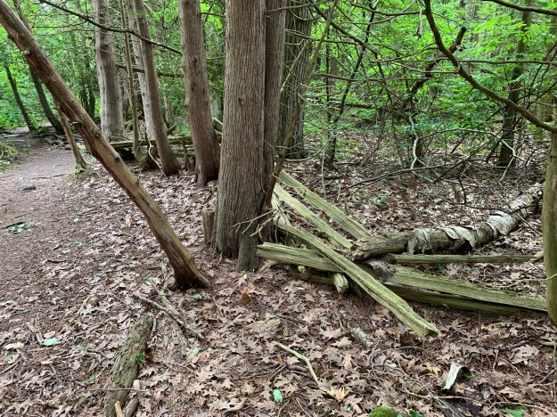
On both sides of Lacey’s Pond the forest is full of cedar trees. The area was likely a cedar forest when the land was cleared for farming, One of the advantages of having a lot of cedar on the property is the availability of cedar rails to make fences from. The Lacey family has used slit rails to make zig-zag fences that now have forest growing up along both sides of the fence and in every corner.
When we returned to Lacey’s Pond we found that a flock of Cedar Waxwings had arrived. These are majestic looking birds with yellow breasts and a black mask on a peach coloured head. They have a crest which sometimes lies flat against the neck. The tips of the wings are red and their tails are squared off with a bright yellow tip. Males tend to have a larger dark area under the chin and unless seen in a larger group it can be hard to identify the sexes.

After making our way back north from the pond we set out looking for post number 33 that would lead us to the northern parts of the forest. The map at the gate shows this part of the forest as being open and the posts are numbered to help guide you through the trails. The maps haven’t been updated yet but the northern part of the forest is intended to be closed permanently. The blockade at this end isn’t obvious anymore.
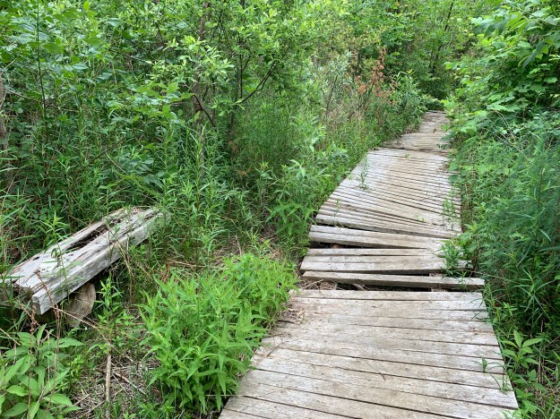
When you come to the section of boardwalk it becomes plain that this section was not repaired. It has some loose boards and places where it rocks underfoot. There are also sections where the rebar that holds it in place stands above the surface of the boardwalk presenting a real trip hazard. When we reached the other end we found that the trail had been closed off and marked as dangerous. Please don’t use this section of the trail and allow it to become fully overgrown.
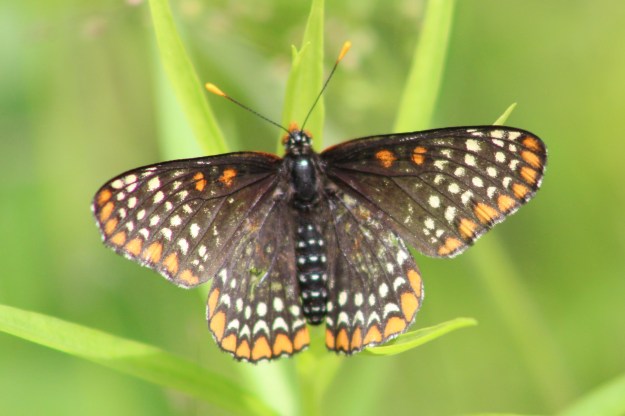
Baltimore Checkerspot butterflies were seen a couple of times before one paused long enough to get photographed. The eggs are laid in bunches between 100 and 700 on the underside of leaves. The caterpillars go through four stages during which time a high percentage is lost to wasps that lay eggs in them. The ones that survive to the fourth stage over-winter in leaves on the ground. In the spring the caterpillars molt and a single fly of Baltimore Checkerspots grace the landscape.
Altona Forest looks like it could be very interesting in every season and we look forward to enjoying a fall day and perhaps a winter day here in the near future.
Our previous feature on Altona Forest can be found at this link: Altona Forest
Google Maps Link: Altona Forest
Like us at http://www.facebook.com/hikingthegta
Follow us at http://www.hikingthegta.com
Look for us on Instagram

Thanks for coming back to update this – very timely as you posted it yesterday and I was looking for detail on the trail today!
I am planning on doing a run that involves going through a part of this forest. Specifically, in this version of the map below, I would enter from the entrance near post 27, run south towards 35, then towards 34 and then out from the entrance closest to 37. Do you know if the boardwalk is decent enough in these parts to run through? Did they clear off some of the vegetation or is it going to stop me from going through? Alternatively, I can enter from post 1 making my way north to 35, and then west towards 37 before going out from that entrance. I am not sure if you got a chance to see these parts but any thoughts are appreciated!
This is the map I am referring to
Click to access 1674-Altona-trail_guide_2011-v8.pdf
Good afternoon. You should be fine using that section of the trail. The closed section is 30 through 16 and it could be dangerous to run through up there.
That’s great – thanks!