
Sunday, May 14, 2017
The East Don Parklands are a much different place today than they were 200 years ago. The corner of Sheppard and Leslie was originally known as the postal village of Oriole and was home to a thriving industrial community. Seven mills and a brickyard lined the valley along the East Don River as it passed through this intersection. The remainder of the valley was used by the various landowners for farming.
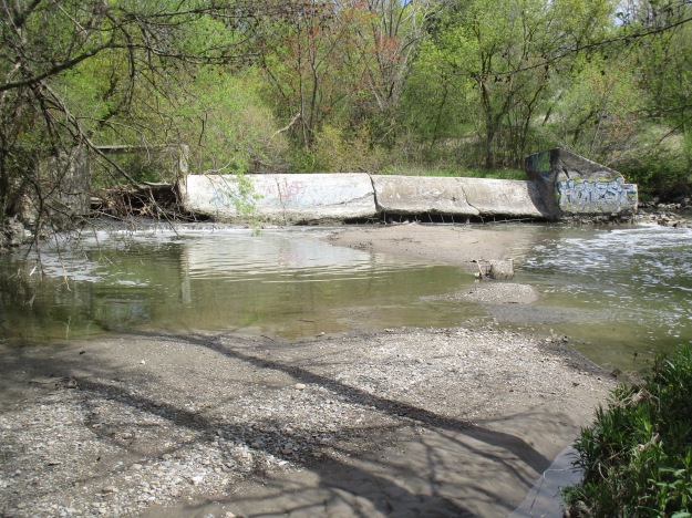
Over time the saw mills, grist mill and woollen mills all disappeared along with the dams that retained their mill ponds. Beginning in 1984 the Toronto Region Conservation Authority began a long-term rehabilitation program aimed at improving the wetlands and restoring the forest cover to the parklands. All of the original mill dams have been removed except for one right at the corner of Sheppard and Leslie beside the parking lot. The river has cut a new path around the east end of the dam as can be seen in the cover photo. Decades of neglect have taken their toll on the dam and large chunks have been removed at water level. An extensive amount of tree branches has gathered behind the old sluice gate on the left. A fence has been installed to keep people from getting on the top of the sluice as it is becoming unsafe. This dam is likely to be removed in the not too distant future if erosion controls are implemented along the watercourse.
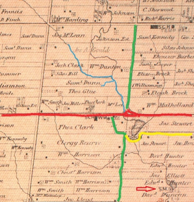
By 1877 when the county atlas below was drawn most of the mills were already gone. I’ve coloured Leslie Street (2nd line east) green and Sheppard (15 Concession) red while a mill access road has been coloured yellow. I wandered along the west side of the East Don River, across the first little tributary and then as far along Newtonbrook Creek as I could. This trek I’ve coloured blue. The south-east corner shows a mill pond in the atlas where North York General Hospital stands today. The sawmill in the curve of the yellow road belonged to Hunter and Sons and was destroyed in the flood of 1878. The first sawmill on this site was Stillwell Wilson’s but it was washed away in a breach of the dam in 1828. Thomas Sheppard then operated a grist mill here until it was lost to a fire in 1869. The concrete dam featured above was on the property that belonged to Mrs. Lee at the time of the atlas. South of here the Duncan Mill is shown with an arrow and it still exists on the property of the Donalda Club Golf Course. Further north, likely on the Gould property, are reportedly the remains of the Philip Phillips sawmill waiting for another day.
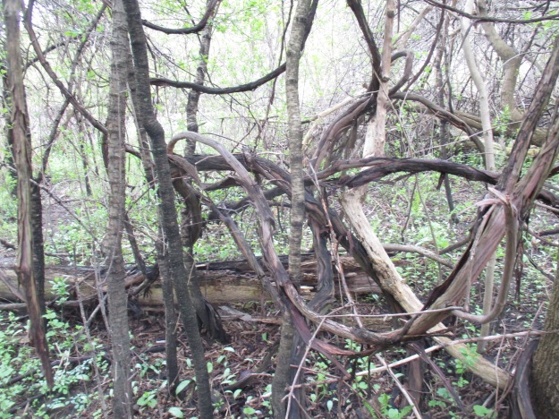
River grapes have become a real problem in the valley. This invasive species has the ability to climb the biggest trees and ultimately can choke the life out of it by covering the canopy. Their twisted vines grow up to two inches thick where they’re well established.
A couple of foot bridges allow you to cross between the two sides of the river but there is a maintained trail on one side of the river only. In addition to the usual families with strollers and dogs, the joggers and cyclists are joined on this Sunday by a marathon running the length of the trail. This makes the trail rather crowded and scares any wildlife away. Most of the waterways in the GTA have a maintained path on one side and a dirt footpath on the other. In a busy park like the East Don Parklands the birds, coyote and any deer will be found on the side with the dirt trail. Therefore, this is the trail I chose.

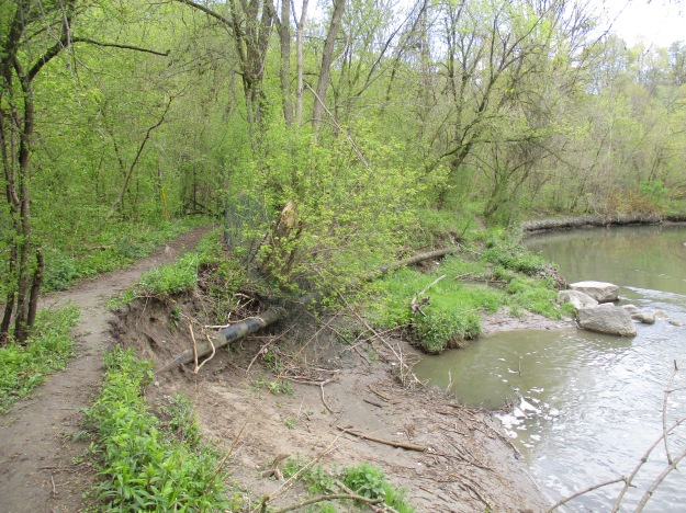
Erosion is a major problem and the river bank has been washed away several feet from the previous shoreline. The natural gas pipeline in this section has been exposed and will now need to be buried again to prevent possible damage to the pipe. This is going to require heavy equipment and likely some of the trees will be removed along the sides of the pathway. In will come the armour stone and at the same time the dam downstream will likely be removed for “safety” reasons.
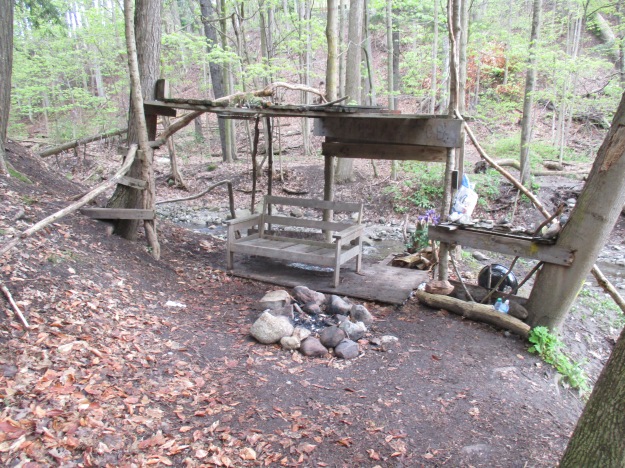
People always find places to hang out and have a cold beer, relax and enjoy the feeling of being in the country, even if you’re not too far from high rises and the subway. In some places, people sit in relative comfort in the little forts they build. This little rest stop is beside the first little tributary and at this time it was easy to cross on the stones that had been provided by the local explorers.
Sections of the trail along the west side of the river have been very wet at times in the past. There are several places where there are logs that have been put down similar to a corduroy road. Recent rain has left the trail pretty muddy in some places. I’m sure this will turn into a mosquito haven in the coming weeks.
More signs of erosion can be seen along the East Don river with large trees bring washed into the river in several places. The Conservation Authority will have to come along and remove them so that they don’t form dams in the river and lead to flooding.

The green frog has large, distinctive, tympani or ear drums that can be seen behind their eyes. They also have two folds of skin that run down either side of the back that are known as dorsolateral folds. They typically have a distinctive green patch on their upper lips. Tadpoles overwinter and transform into frogs the following spring.

Having taken the trail on the west side of the river I was forced to turn back when I came to Newtonbrook Creek because I couldn’t get across. This leaves a large section of the park between here and Old Cummer Road that still needs to be explored, including the Stillwell mill site.
Google Maps Link: East Don Parklands
Like us at http://www.facebook.com/hikingthegta
Follow us at http://www.hikingthegta.com

Ahh love all your stories. I would love to belong to your group. Love this stuff!!
There was once a drive-in theatre just north of Sheppard and east of Leslie st.
I’ve fished for salmon in that stretch of the river for years. There is another dam north of Cummer Ave. just north of the forks with the German Mills Creek. Any idea when these dams were last used for their intended purpose?
The dam at German Mills Creek and The Don was for Cupper’s Grist Mill. It is mentioned in an 1885 history of Toronto. If the dam is made of concrete it was built after 1900 but I have no record of when the mills ceased operations.
Pingback: Flynntown – Ghost Towns of Toronto | Hiking the GTA
Pingback: Betty Sutherland Trail | Hiking the GTA
I remember the dam. Nearby was the last one room school house in Toronto. The teacher was Mrs Kidd. She ended her career teaching at the newly opened Elkhorn school.
The Sheppard Oriole dam was the local swimming hole in the ’40s and early ’50 for us kids living in the Lansing area at a time when the Don was just beginning to be polluted. Also, as a child us kids sometimes played in Donnar’s (sp) barn just up river from the dam on the east side of the river, it was exciting for all of us when the infamous Boyd Gang was discovered hiding in the barn around 1950 ending Toronto’s most famous man hunt.
When we moved to 370 Sheppard in 1943 Oriole was still a rural area but one that had transformed from a farming to an estate area for Toronto’s elite. Great to see the restoration and conservation of this historic river.
Pingback: Ghost Towns of Toronto | Hiking the GTA
In the mid 1960’s the Don was more polluted than it is today but there was still a lot of wildlife. A friend and I caught turtles at the dam, which was still intact. We even took colour pictures of them which I still have. We also used to steal wood from Oriole Lumber to make forts. They eventually relocated the yard but kept the name. It could still be in business.