Sunday, March 18, 2018
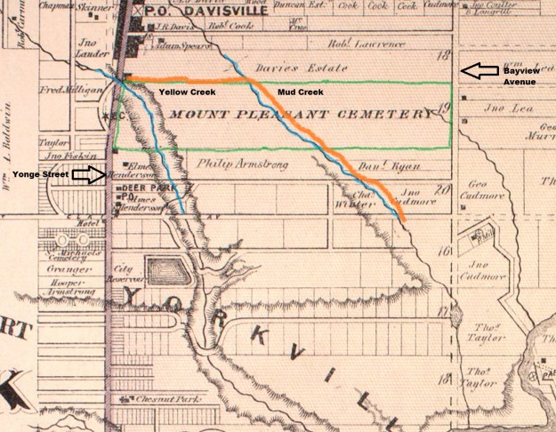
When Mount Pleasant Cemetery opened in 1876 it was comprised of the entire 200 acres of lot 19, just north of present day St. Clair Avenue. The cemetery developed eastward from Yonge Street and we examined the history and some of the monuments and mausoleums in the earliest sections. They can be found in our post entitled Mount Pleasant Cemetery. The undeveloped end of the cemetery would be cut twice for transportation routes. In 1915 The government bought the rights to a strip that would cut the cemetery in two halves. To commemorate this, the new extension to Jarvis Street was named Mount Pleasant Road. It had previously been severed for the right of way for a commuter railway line. The 1877 County Atlas below does not show either the new road or railway. Yellow Creek has been drawn in the atlas as being in a ravine as it passes through the cemetery, which is outlined in green. Mud Creek rises out of a steep ravine and flows across the cemetery on a much shallower one. I’ve marked the railway line in orange. As a side note, the Davisville Post Office shown on the map still exists as a Starbucks on the corner of Yonge and Davisville.
With an economic boom going on in Toronto a plan was developed to sell lands north of the developed city and service them with a commuter railway to be known as the Belt Line Railway. When it was revealed that the proposed railway would follow Mud Creek and then pass through the cemetery the plan was opposed by the The Toronto General Burying Grounds Trustees. Moore Park Station was proposed for just south of the cemetery at the top of the ravine and it was designed as the grand masterpiece of the railway. The Trustees were eventually convinced that the proposal would help establish the cemetery as a Victorian country garden destination and it would gain in the end.
The housing boom didn’t happen due to an economic crash and the railway only operated for a little over two years. The first passenger train ran on July 30, 1892 and by November 17, 1894 the service was shut down. The former right of way for the Belt Line Railway was a prime piece of real estate and Toronto City Planning Commissioner Tracy Lemay had a plan for a high speed expressway that would link the Lakeshore with Mount Pleasant Road. This was part of a larger plan of roadways that was never fully implemented. Fearing that they would be cut off from the east end of their property the trustees commissioned a bridge over the railway right of way.
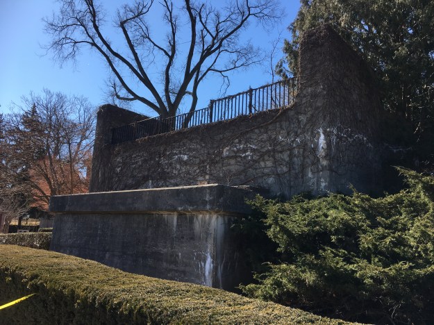
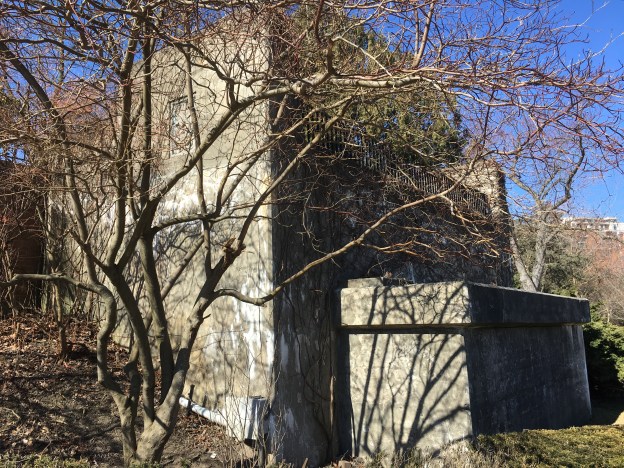
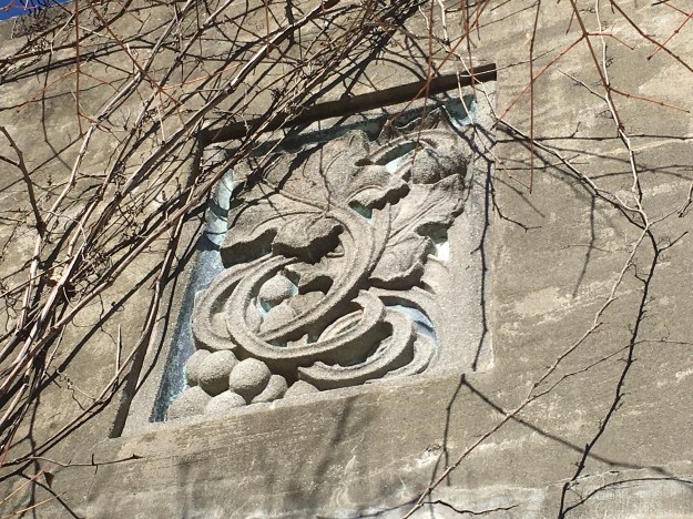
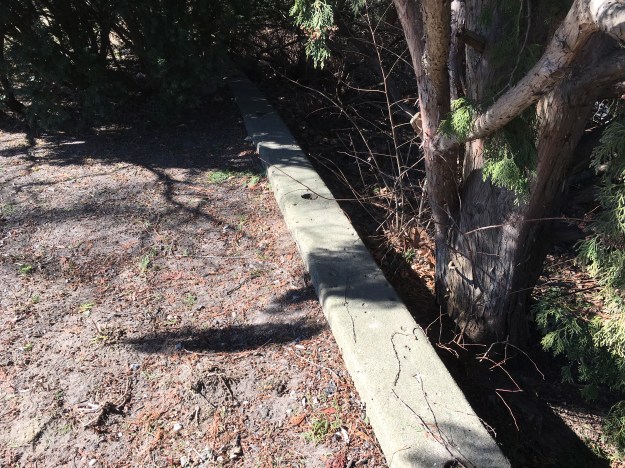
The expressway was never built and the cemetery ended up with a bridge over a shallow depression. The bridge stood from 1929 until the early 1970’s when it was demolished because it had deteriorated. Like everything else in the cemetery, the former bridge also has become a monument. The west abutment has been left as a reminder of the bridge. In a way, it is a testament to a failed railway enterprise and an expressway that was never more than a dream. The concrete is adorned with a symbol of vines and grapes. The vines represent continuity while the grapes are a Christian emblem that remembers The Last Supper.
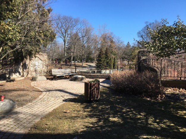
The top of the abutment has been turned into an area for quiet reflection behind the cemetery offices.
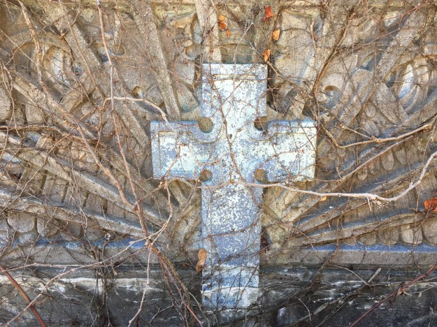
The insides of the bridge are adorned with painted images of the cross. The cemetery was started as a secular one and it seems interesting that the symbolism is Christian within about 50 years of the opening.
The original guard rails on the approach to the bridge have been removed.
This areal photo taken in 1947 and found on The Toronto Archives shows the bridge.

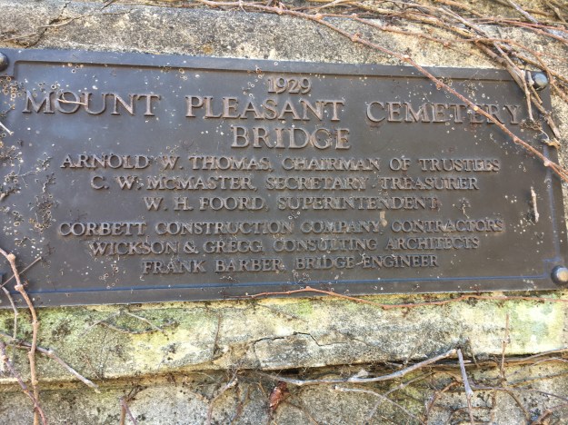
A plaque on the inside of the bridge pays respect to those who were involved in the plan to stay ahead of the city planners.
Google Maps Link: Mount Pleasant Cemetery
Like us at http://www.facebook.com/hikingthegta
Follow us at http://www.hikingthegta.com

Hi Steve,
I’ve been trying to get a series of hikes going that will take New Canadians out and about in Toronto (Culture Link’s Meetup program under “Neat Walks”. I’ve done a prehike of Vale of Avocado (figure to meet at St Clair Subway, coming out via Millman’s lane and over toSherbourne subway.
Then again with my “Mentee” got to check out entering Milkman and then over to Brickworks. All frozen trails though so did not do those hikes yet.
Also have prehiked Glen Stewart Ravine to RC Harris. That place is great! Love the little waterfront seen through a window kind of advertising their product.
No one showed up today though so will have to reschedule but I’m starting this lingering cold weather is keeping my New Canadians inside.
Hope to line up a few other hikes, mywork schedule permitting but things are getting busy but would really like to see this “Discovery Walk” program get going.
I’m trying to do these by using TTC subway/bus. For instance, today it was Bloor subwayto Main St Station, meet there then we all go #64 to Kingston Rd then walkoverto the Ravine. So maybe reschedule all that.
Getting all my ideas and inspiration from your writing, so well researched it seems.
So if you have ideas that our New Canadians should see any suggestions are most appreciated. Links will be fine, thanks.
Now back to scheduling and trying to give at least two weeks notice. Kind of difficult but hope to make it all work eventualy!
Thanks
Grant Leigh 416-837-0404 cell
Great idea, Grant! As new immigrants in 1952, my parents were thirsty to soak up the history of our Acton home. Dad took us exploring the countryside in our 1947 Dodge while we taught him to sing O’ Canada and The Maple Leaf Forever.
Only draw back to exploring on foot was the clothes we had! My parents literally got off the boat with two kids and $60! Gradually, helpful neighbours provided us with winter clothing.
Maybe clothing is why New Canadians hesitate to hike in colder temps. Hopefully, warmer weather will bring them out.
Keep up the good work!
I realize this link is over two years old, (pre-COVID), but I thought I would send along my comments. Thank you so much for posting this. I taught ESL for years, and it was difficult to obtain information about Toronto’s early years. I grew up steps away from the Vale of Avoca, and was always curious about the history of this area, but could never find a source. As children, The Vale of Avoca was just referred to as ‘the ravine’ where we used to toboggan. It wasn’t until the school I attended, Deer Park, held their 100th. anniversary, and published a booklet, with pictures and history of this area. Unfortunately, I loaned this booklet to a friend of my father’s and it was never returned.
In recent years, I joined Ryerson’s Life Group, for retirees, and we hiked throughout Toronto, learning about the various districts and their history. I’m so glad you are giving your students the opportunity to learn about Toronto’s fascinating history.