Saturday, June 9, 2018
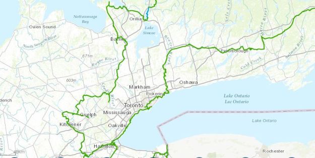
The idea for a Trans Canada Trail was given birth at the time that the country was celebrating 125 years of Confederation. The plan was to complete a trail that would link all the provinces and territories by 2017 when the country celebrated 150 years. In a quarter century a trail was created that extends over 42,000 kilometres and is the longest multi-use trail network in the world. The trail passes directly through the GTA and then curves back along the top again as it heads north. The map below was snipped from the official map https://thegreattrail.ca/explore-the-map/
A non-profit organization called The Trans Canada Trail was established to raise funds for the creation and maintenance of the trail. All levels of government contributed to the project and donations were sought from corporations and individuals. The province of Prince Edward Island was first to complete their section which is known as Confederation Trail. To explore the original section of the trail we parked in the small lot on The Gore Road just north of Old Church Road. After a short walk east toward Mill Lane and Humber Station Road we made our way west to Caledon East.

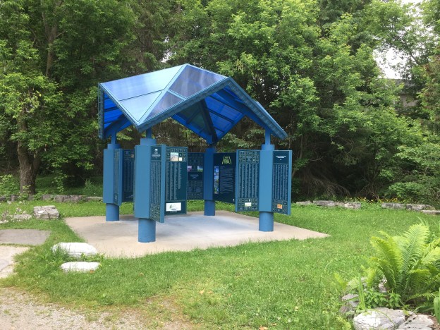
Pavilions have been established along the route where donors are recognized. The first pavilion to be created is the one in Caledon East. An inscription program was put in place for individuals who donated to finance a metre of the trail. An inscription would be added to the pavilion of your choice. My family had a inscription placed in the Calgary pavilion, the city where our late brother was born. The inscription program was officially terminated in 2012 when it was determined to be a drain on resources that was hindering the actual development of the trail. If you donate today, the federal government will give 50 cents on the dollar as donation matching.

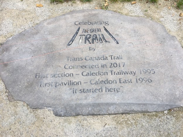
The trail has been established using existing trails as a foundation. The first section to be opened was the Caledon Trailway in 1995. When the trail was connected from The Atlantic to The Pacific and Arctic Oceans in 2017 a new stone and pavilion were placed in Caledon East where The Trans Canada Trail was first opened. The stone bears the new name of the trail.
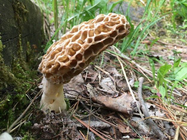
The trail has been connected from coast to coast but it is far from completed. Large sections follow roadways which in some cases are temporary until green-ways can be developed. In other areas the trail may always be stuck on the side of roadways, mostly rural but also including some busier sections. Some portions, such as one in New Brunswick on the Saint John River cannot be hiked or cycled, but must be completed in a boat or canoe. The trail is intended to promote six main activities: walking/hiking, cycling, paddling, horseback riding, cross-country skiing and snowmobiling. Along the trail near Caledon East we found a single True Morel growing. These fungus are edible and can be distinguished from similar inedible ones by the fact that they are hollow inside, from stem to tip of the mushroom.
The section of trail that passes through Caledon East follows the route of the Hamilton and North Western Railway which was later amalgamated into the Canadian National Railway. It was abandoned in the 1980’s and Caledon purchased the right of way in 1989. In 1994 they started to convert it into a multi-use trail which opened the following year. The trail along here continues to use the old rail bridges to cross streams and roadways. This is the bridge over Mill Lane.

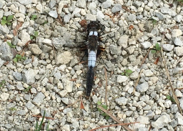
Dragonflies rest with their wings open while damselflies rest with them folded on their backs. There are about 5,000 species of dragonflies in the world and 130 of these have been identified in Ontario. We saw half a dozen different ones along the way. This male Chalk Fronted Corporal was one of several that were soaking up the heat on the trail. They tend to follow humans as they hike because they like to eat the mosquitoes and biting flies that are attracted to people. For this reason it is always nice to see these insects.
We found a patch of gooseberries growing along the trail. They are not native to North America but have become naturalized, likely from garden escapees. The fruit is cultivated and is an excellent source of vitamin C. It can be eaten as is, cooked into pies or preserved in jams. It is also used to flavour wines, sodas and teas.

The Humber Valley Heritage Trail along with The Bruce Trail are accessible from the Great Trail near Caledon East. In other places The Great Trail shares pathway with The Lakefront Trail and The Pan Am Trail. The pedestrian bridge crossing the mouth of Highland Creek is one example of a shared trail.

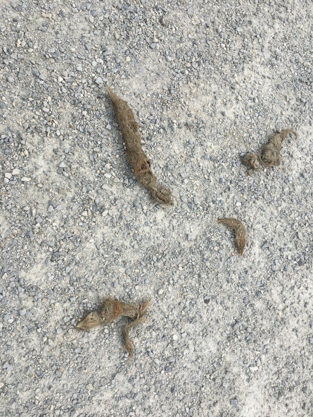
Based on the amount of fur in this scat it appears that someone is not doing the stoop and scoop after their coyote.
Along the trail we saw several chipmunks and squirrels as well as this rabbit. The hunting seems to be pretty good for the local coyote population.

We’ve visited several sections of The Great Trail along the Waterfront Trail as well as on The Caledon Trailway. At 42,000 kilometres in length, this is one trail that few will be able to complete end-to-end.
Google Maps Link: Caledon East
Like us at http://www.facebook.com/hikingthegta.com
Follow us at http://www.hikingthegta.com

The Caledon Trailway follows the right of way of the CN railway line that fell into disuse in the early 1960s. In 1889 a stone arch culvert was constructed over the Humber River. The engineer who designed “The Arch” also designed the 1890 rail tunnel under the St. Clair River between Sarnia and Port Huron. A pool was formed on the east side of the culvert and was used as a swimming hole by the local residents. A wooden platform can still be seen at the location.
The old timers recall with some sadness how “the Patterson boy” drowned in the river some time in the 1930s. Unfortunately the walls of The Arch have been defaced with graffiti. The Town of Caledon has been made aware of the damage and has committed to a cleanup as the structure is a designated heritage site.
Pingback: Caledon’s Stone Culverts | Hiking the GTA