Tag Archives: Devil’s Punch Bowl

Dofasco 2000 Trail

Saturday, March 16, 2019

When we previously visited The Devil’s Punchbowl we had noted the Dofasco 2000 trail that runs east from the falls.  With all the rain and melting snow it seemed like a good time to revisit the falls and hike a section of the Dofasco 2000 Trail.

For parking you have several options.  The Devil’s Punchbowl Conservation Area has parking for $5.00.  Alternately, there is parking for at least a couple of cars where the Dofasco 2000 Trail crosses each of the four roads east.  Depending on the length of walk you desire you can continue on Ridge Road as far as Tapleytown Road.  Second Road East has the most parking places.  We decided to walk the full four side roads to the Punchbowl and back.

Dofasco 2000 Trail

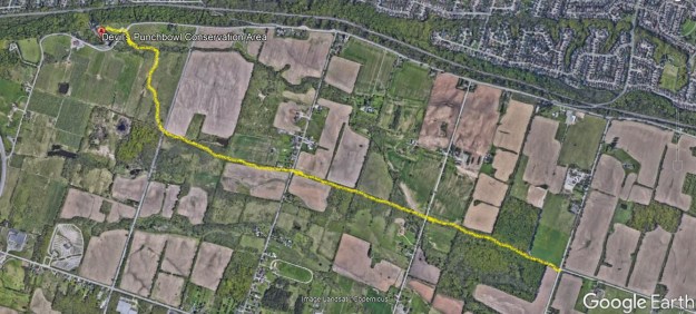
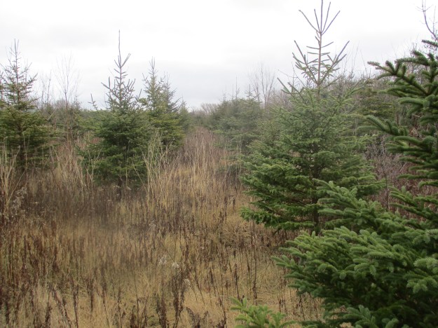
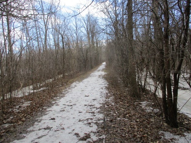
This was our final hike of winter and the day wanted to prove that the season wasn’t over yet.  The trail was hard packed with ice in a few places and open in others but the fresh snow made the walking challenging.  The trail follows an unopened road allowance and was pretty much ours alone with the exception of a couple of dog walkers.  While we’re on the subject of dog walkers, do people really think that dog poo will just melt away with the snow?  This trail was marked with several months of deposits as well as dozens of Tims cups.  Certainly one of the messier trails we have visited in recent times.

IMG_2489

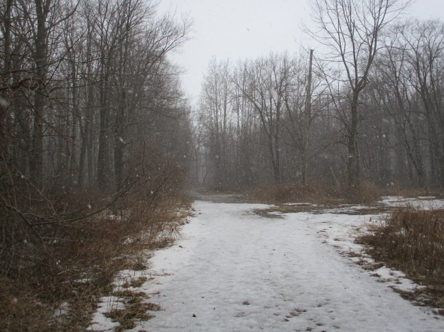
An old building stands in the woods along the side of the trail made out of prefabricated concrete blocks that were designed to look like cut stone.  There is a date of 1943 etched into the concrete in the doorway and inside it appears to have been used to house a generator.  More recently it housed someone who slept in one corner and kept a small fire in the other.

IMG_2478

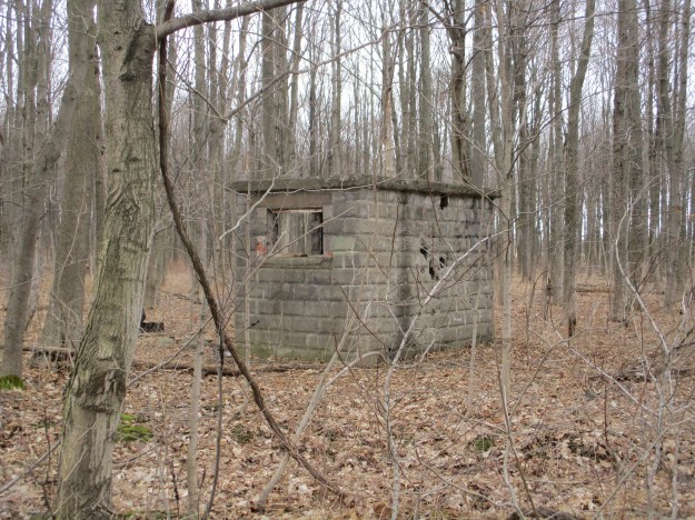
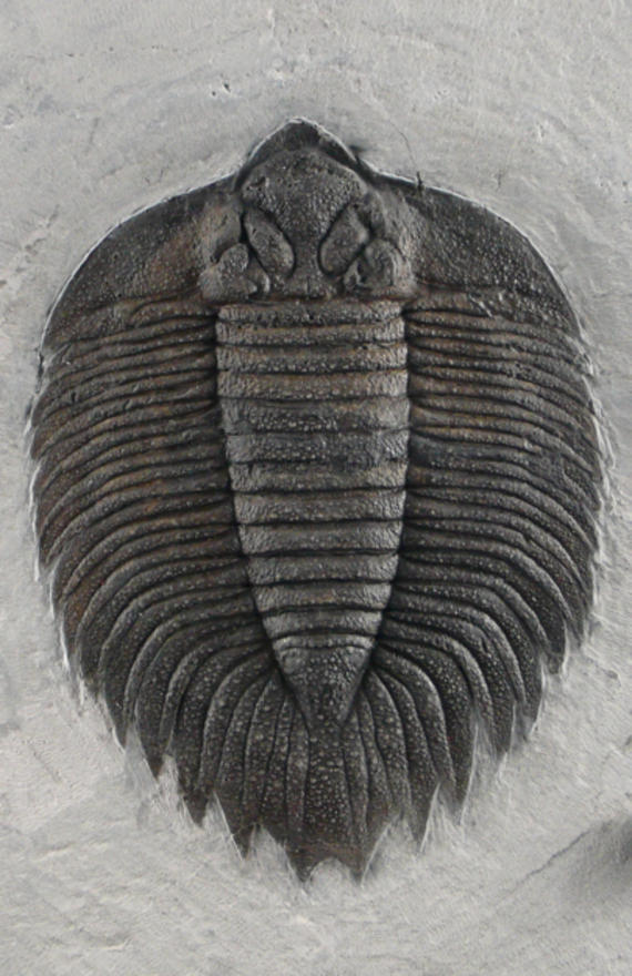
Sections of the forest have been tapped for maple syrup production and both new and old equipment is strung through the trees.  Nature has a way of adapting and has started to grow around this old metal sign on this tree.  We saw plenty of evidence of last year’s fungi which suggests a healthy forest as this is the natural way of breaking down the wood as it begins to decompose.

IMG_2476

As we continued along we were treated to patches of blue sky and sunshine.  Spring is just around the corner and the weather was attempting to give us a preview of the new while reminding us of the old season.

IMG_2471

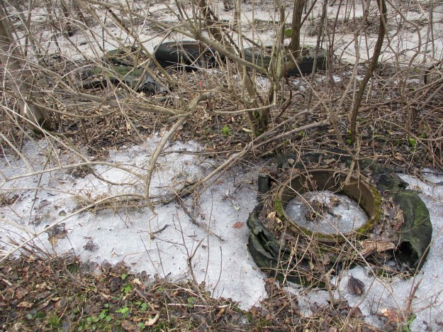
Half a dozen old tires are rotting on the roadside with rusted rims and degrading rubber.  The rubber will take between 50 and 80 years to disappear but the metal rims are destined to be there for up to 200 years.

IMG_2467

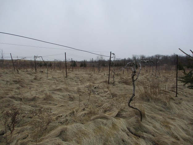
The path runs through a vineyard with rows of grape vines stretched out on either side of the trail.  Ridge Road is home to several wineries as is the entire southern portion of the Niagara Escarpment.  There are an average of 205 frost free days per year in the region allowing production of 71,000 9-litre cases of wine annually.

IMG_2461

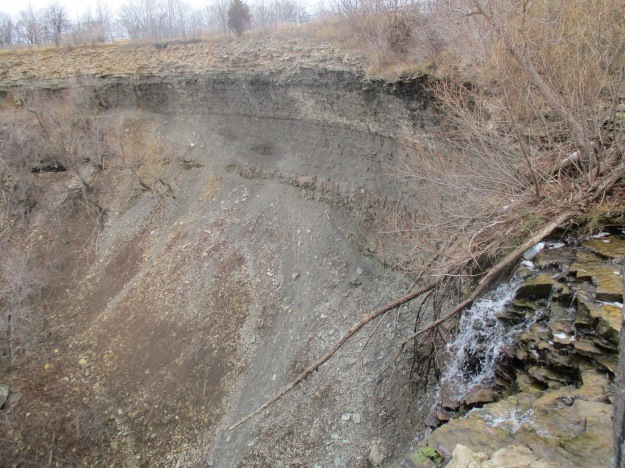
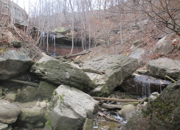
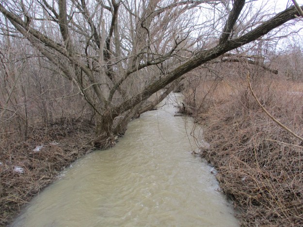
A small bridge carries you across Stoney Creek.  This is only a short distance above the waterfalls at The Devil’s Punch Bowl and the high water levels in the creek suggest that the falls might have a good flow of water going over.

IMG_2459

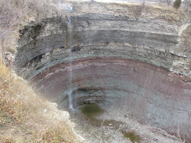
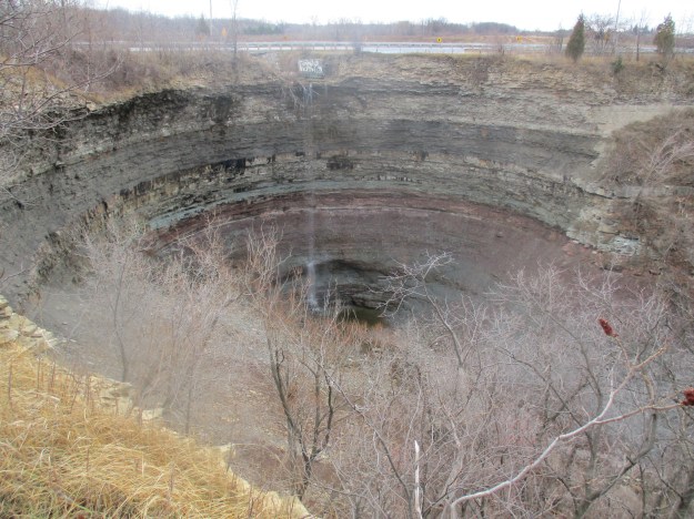
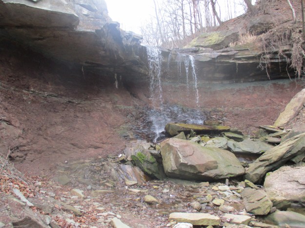
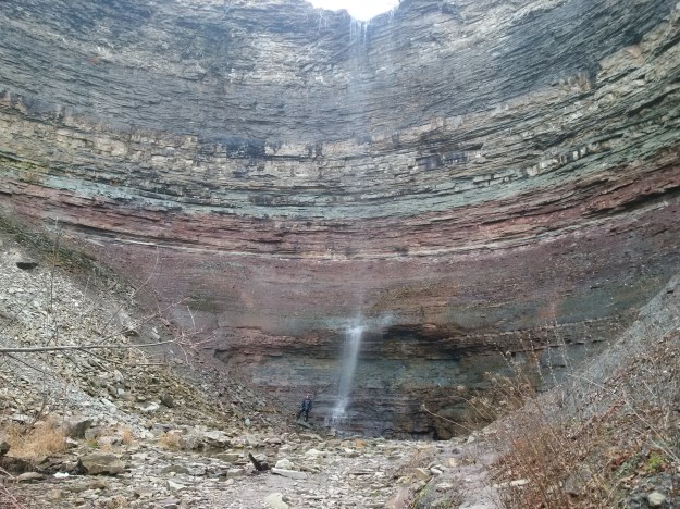
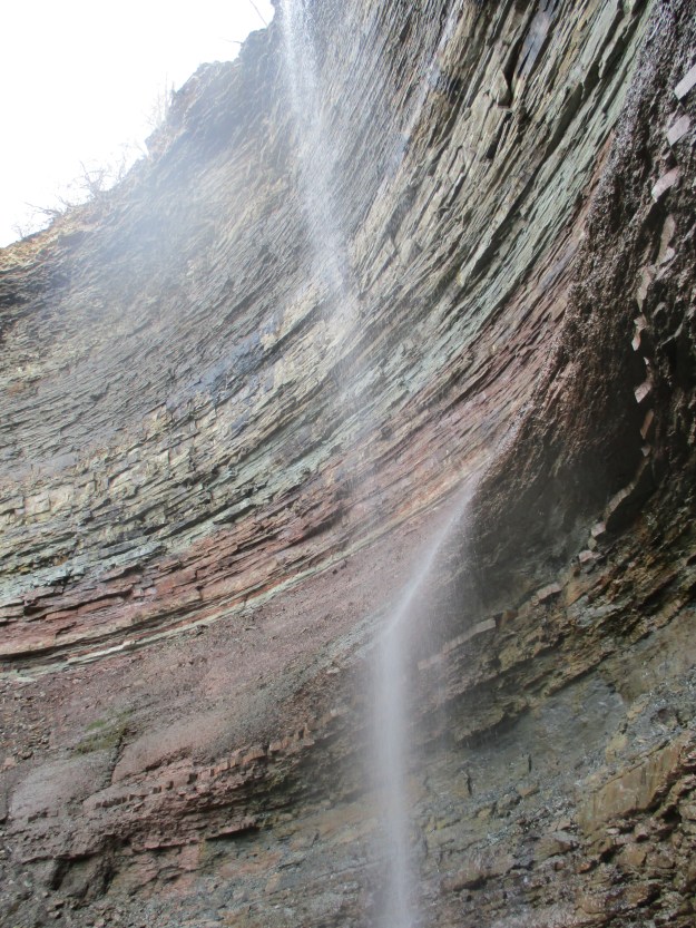
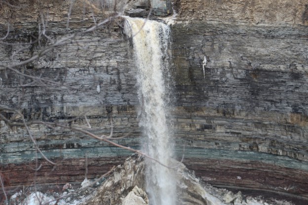
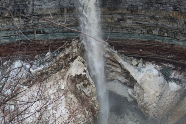
The Devil’s Punch Powl Conservation Area provides the most scenic point on the trail.  Recent weather conditions suggested that the water flow might be near the peak level.  It turned out that there was quite a bit more water plus a bonus ice formation in the bottom of the cone.  The falls are interesting from a geological point of view because they expose all the layers that make up the Niagara Escarpment.  The geology of the falls along with plenty of other pictures, including the lower falls, can be found in our story The Devil’s Punch Bowl.

IMG_2455

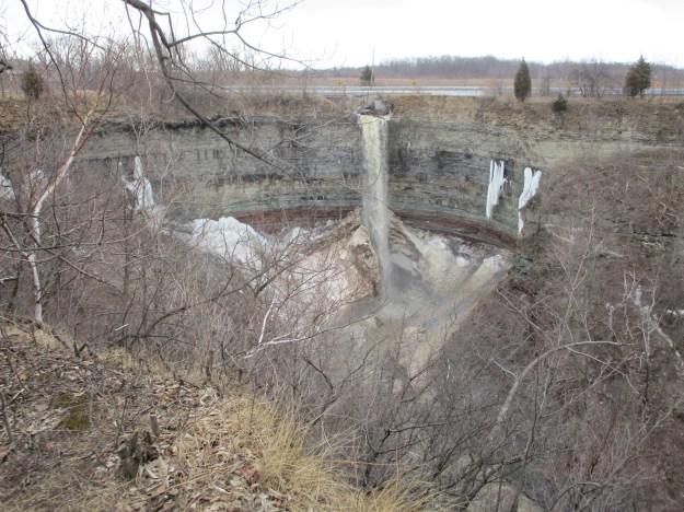
Given the 37 metre height of the falls, the ice cone at the bottom has to be about 20 metres tall.  This is truly spectacular to behold but is limited to late winter and early spring viewing, depending on the type of winter season that we get.

IMG_0105

The Dofasco 2000 Trail continues east of the fourth road on pavement for one concession before entering a closed road allowance again for another five side roads.  It passes through the Vinemount South Swamp on a 1.7 kilometre boardwalk that likely needs to be explored before or after mosquito season.

Google Maps Link: Dofasco 2000 Trail

Like us at http://www.facebook.com/hikingthegta

Follow us at http://www.hikingthegta.com

The Devil’s Punch Bowl

Saturday Dec. 26, 2015

The Devil’s Punch Bowl is a 37 metre gorge in the Niagara Escarpment near Stoney Creek where all the various strata of the Paleozoic era can be seen together.  Their colourful sequence along with a pair of waterfalls makes this a gorgeous gorge.  There is paid parking in the Devil’s Punch Bowl Conservation parking lot on Ridge Road in Hamilton.

The history of the Devil’s Punch Bowl name has been lost and all that remains are stories.  One of these stories suggests that moonshiners were working along the Ridge Road and would go into the falls to get pails of fresh water for their wares.  Regardless of the origin of the name it is just one of the local geological features that have been given devilish nomenclatures.  Two other ones are The Devil’s Pulpit and The Devil’s Well, all three of which are far more beautiful than their names suggest.  The history of the gorge is as old as the escarpment and it’s formation over 450 million years ago.  The colours seen in the rock show the various layers as they were laid down in a vast inland sea.  The bowl itself was formed at the end of an ice age a million years ago from the flow of melting ice caps.  The picture below shows the gorge looking away from the punch bowl and toward Hamilton.  A steel cross stands on the right side of the gorge where it has been lit since Dec. 18, 1966 when it replaced a wooden cross on the same location.  The Toronto skyline can be seen from near the cross.

IMG_2057

The picture below was taken from the top of the gorge where Stoney Creek plunges over the side.  Sometimes there’s a strong ribbon waterfall here but today the water level was very low.  The sides of the gorge have been filled with piles of talus which hides all but the upper rock layers. Over the years, erosion has broken rock debris off the sides of the gorge until it accumulates in sloping piles most of the way to the top. This makes decent of the sides impossible although I did notice the remains of rappelling anchors on the side of the old bridge abutment near where this photo was taken.

IMG_2067

The road passed much closer to the Punch Bowl a hundred years ago.  Half of the north bridge abutment has broken off and fallen toward the creek.  The other half has been defaced with graffiti.  The bridge is right on the brink of the falls which means that either people were more adventurous in the past or the cliff edge is eroding back with time.

IMG_2056

As you walk along the side of The Devil’s Punch Bowl you can see full depth of the gorge and the waterfall.  The cover photo also shows the concrete bridge abutment where the road used to pass closer to the gorge edge .  There are stories of people who have either jumped or fallen to their death in the punch bowl and it is important to keep back from the edge as it can give way at any time.

IMG_2080

We descended a blue side trail to reach the level of Stoney Creek so we could make our way back into the punch bowl.  The creek bed is littered with broken pieces of Whirlstone formation sandstone that have trees growing up between them.  Along the way, between the train tracks and the lower punch bowl, the creek cascades over several minor waterfalls.

IMG_2103

The lower punch bowl is 7 metres deep and 7 metres in diameter.  This second waterfall exposes another formation that is not visible in the upper punch bowl.  The harder sandstone of the Whirlpool formation sits on the bedrock of the Niagara Escarpment which is known as the Queenston Formation and is named after the town of Queenston.  The Queenston formation is made of maroon coloured shale that formed in slow moving waters in an area known as the Queenston Delta.  The red comes from oxidation of iron minerals and the grey-green layers contain shale that has gained an electron during oxidation in a process known as reduction.  This layer can be up to 300 metres thick and is often devoid of fossils.  The sandstone is harder than the shale and therefore it erodes slower leaving an overhang at the lower falls.  This shelf will eventually break off as can be seen by the sandstone chunks at the bottom of the falls.

IMG_2106

This is the same layer that is exposed at the Cheltenham Badlands where this picture was taken on July 4th, 2015.

IMG_6256

We passed the lower punch bowl and continued to climb the creek bed uphill.  As you enter the Devil’s Punch Bowl from the bottom you pass by sloping talus on both sides to emerge into the round inner bowl.  Even with only a limited waterfall the sight is incredible.  In the picture below a person is standing on talus to the left of the plunge pool at the bottom of the falls.  This gives some indication of the height of the gorge at this location. There are at least 10 distinct formations or layers that can be seen here.  The bottom visible layer is the Whirlpool formation which forms the upper shelf of the lower punch bowl falls.

Bowl

The capstone of the Niagara Escarpment is known as the Lockport formation and is a hard dolostone.  It has two distinct layers with the second being the first thin light line and below it is the softer Rochester Shale formation which is a darker grey band.  It appears near the top of the picture below.  A second thin light band of dolostone lies just below it.

IMG_2117a

This shale formation is known for it’s heavy concentration of marine fossils including many trilobites.  The picture below is not mine, unfortunately, but shows one of these fossils that was found in the same geological layer in New York State.

trilobite-arctinurus-boltoni-2_pinboarditemoverlay

The waterfall bounces off of the reddish layer known as the Grimsby formation.  Directly above it is a grey-green layer known as the Thorold formation.  These two sections, and specifically the contact point between them, provide much of Ontario’s gas production along Lake Erie.

IMG_2115

We followed a blue side trail which runs along the the north side of the gorge and links back to Ridge Road.  Along the side of the trail stand the foundations for a former building which had a grand view of the Devil’s Punch Bowl.

IMG_2121

As we returned to the car we took a minute to investigate the start of the Dofasco 2000 trail which is right across the street from the parking lot.  This 11.5 kilometer trail will connect to Battlefield House where the Battle of Stoney Creek took place on June 6, 1813.  We only went a short distance where runs through what appears to be an abandoned Christmas Tree farm. This trail offers a potential future exploration.

IMG_2055

The Devil’s Punch Bowl can be found at N43.21045 W79.75594

Like us at http://www.facebook.com/hikingthegta