Tag Archives: Hamilton

Chedoke Ski Hill

Saturday, November 30, 2019

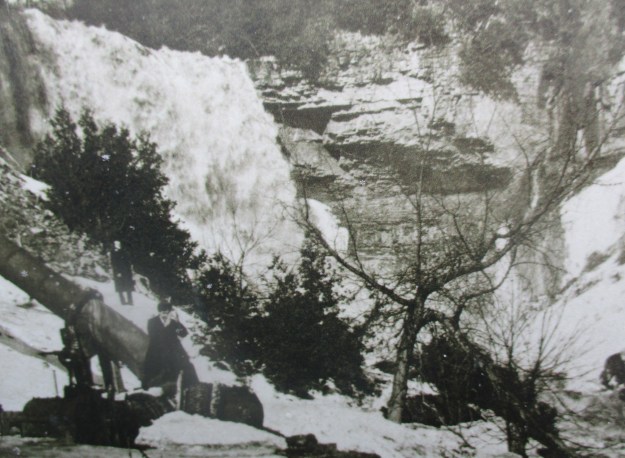
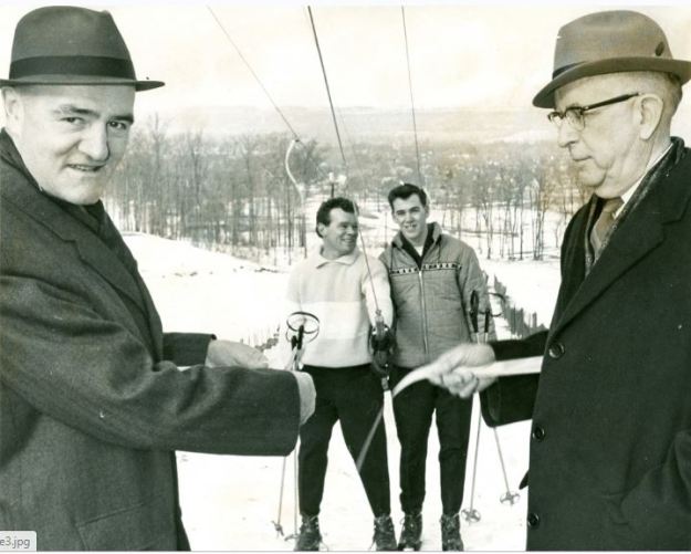
On January 7, 1964 Chedoke Winter Sports Park was officially opened.  Mayor Vic Copps and  head of the parks board Thomas Newlands cut the ribbon that opened the first run with its 900 foot tow rope.  Over time two more tow ropes and a chair lift would be added along with sled runs.  The park operated until 2002 when poor snow conditions caused the city of Hamilton to decide not to open it that year.  The following year it was closed permanently with the city citing an annual loss of $250,000.  The cost of upgrading the snow making equipment to be able to perform in warmer temperatures along with lift upgrades would have cost an additional $3,000,000.  Over the next few years most of the poles and lift equipment was removed guaranteeing that it would never open again.  The picture below was taken from The Hamilton Spectator and shows the ribbon cutting ceremony that opened the park.

Chedoke opening

The winter sports park added additional ski runs over the years as well as more tow lifts.  Eventually, a run would be opened from the top of the escarpment and it would be served by a chair lift.  Sled runs were also added and the park served as a winter destination for the next four decades.  Attendance declined over the years and the cost of operating the hill continued to increase until the city decided to close it permanently.

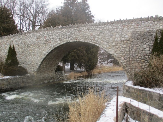
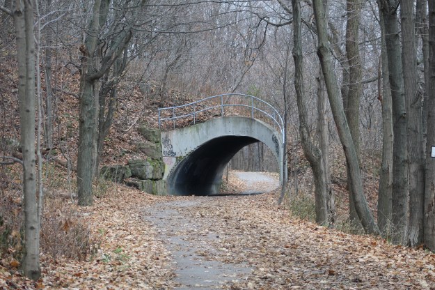
The Chedoke Rail Trail runs along the bottom of the escarpment near the Chedoke Golf Course and it has one unusual tunnel just north of the parking lot.  This tunnel allowed pedestrians to pass under the tow rope that carried skiers back to the top of the hill.  The tunnel is flanked on both sides by abandoned lamps that lit the former ski hill.

IMG_8573

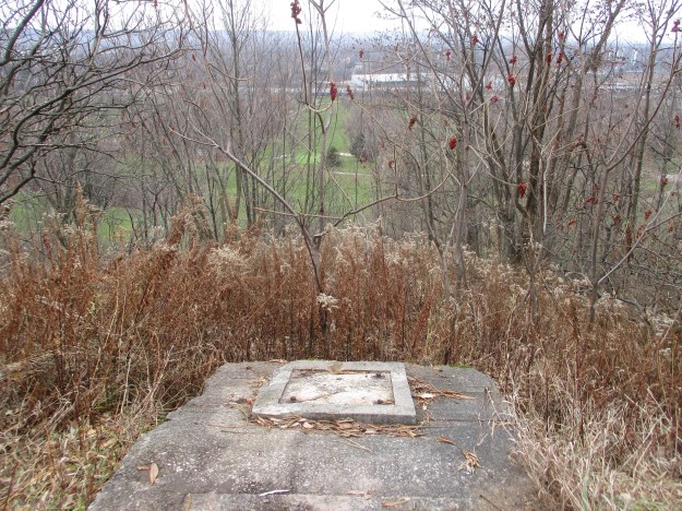
This tow rope supported one of the shorter runs and ended just a few metres above the  Bruce Trail.  The concrete pads where the upper wheel was located have been left behind.  Near this spot is an open pit that contained snow making pipes and equipment so watch where you step if you explore this area.

IMG_8537

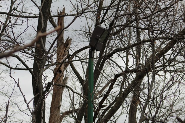
Each of the ski runs was lit for night skiing.  Although the lift mechanisms have been removed, the light fixtures were left behind.  They will slowly be overtaken by the new forest growth and will seem somewhat out of place to future explorers after the ski hills have been forgotten.

IMG_8586

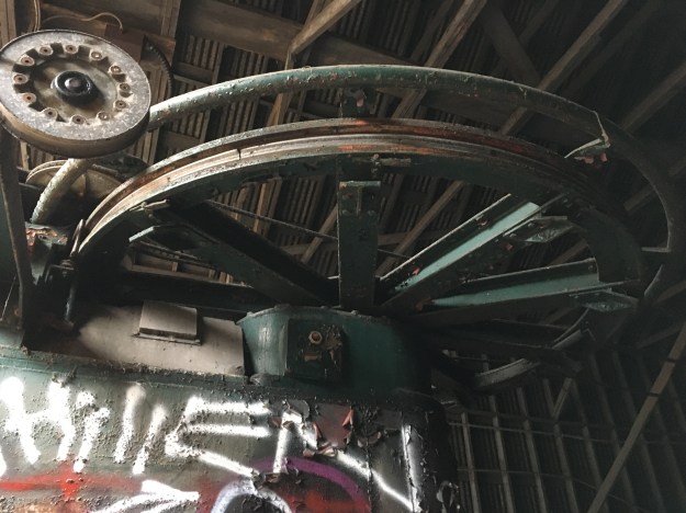
Between 2003 and 2009 most of the lift equipment was removed from the site.  All of the lift poles and tow ropes were disassembled and carted away except for the main drive unit for the chair lift.  It still stands at the bottom of the longest run, hiding in a green shed.

IMG_8567

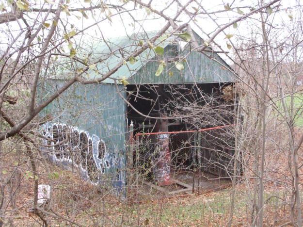
Inside the shed the main wheel and drive assembly still stands although the lift cable has been removed.  The wheel assembly is mounted on a pit in the floor that allowed the mechanism to be pulled backward by means of a hand crank and a series of cables.  This was used to keep the tension on the main lift cable.

IMG_3029

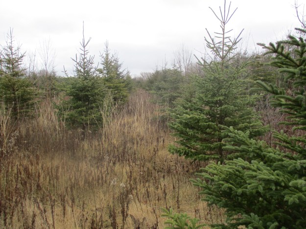
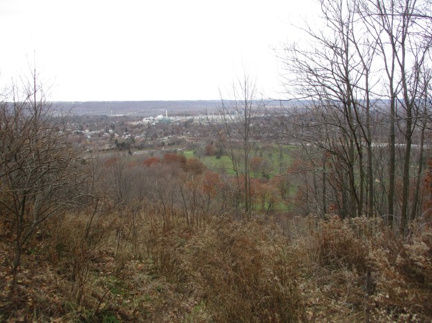
From outside of the lift shed the view up the hill reveals how quickly the trees are creeping back onto the ski slope.  The lift towers and chairs have been removed so we had to climb to the top.  The Bruce Trail crosses the slope about half way up the picture.

IMG_8587

Three rows of PVC pipe run down the length of the longest run.  These were used for the snow making equipment.  Expensive upgrades to this system  to allow snow making in warmer temperatures were cited as part of the reason for closing the site down.  The lift poles were removed that ran along beside these pipes and yet they were left behind.  It wouldn’t have taken much more effort to cut these up and cart them away while they were at it.  Estimates suggest that these pipes will still be laying here in the year 2500 if no one collects them.

IMG_8557

From the top of the escarpment you get a nice view out across Burlington Bay.  The first part of this run is pretty steep and was the adrenaline rush that the more experienced skiers were looking for.

IMG_8593

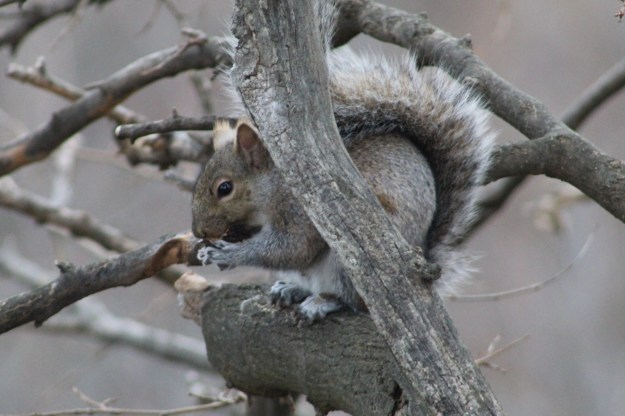
From this location on the top of the hill you are close to the old Mountain Sanatorium where they used to treat people with tuberculosis.  The sanatorium is now abandoned and most of the buildings have been torn down.  The Cross of Lorraine still stands at the top of the escarpment to mark the old hospital and it is visible from the trail below.  The gray squirrel has an average lifespan of 6 years if they make it past their youth.  Records show lives of up to 20 years in captivity.

IMG_8614

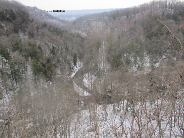
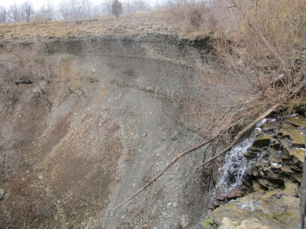
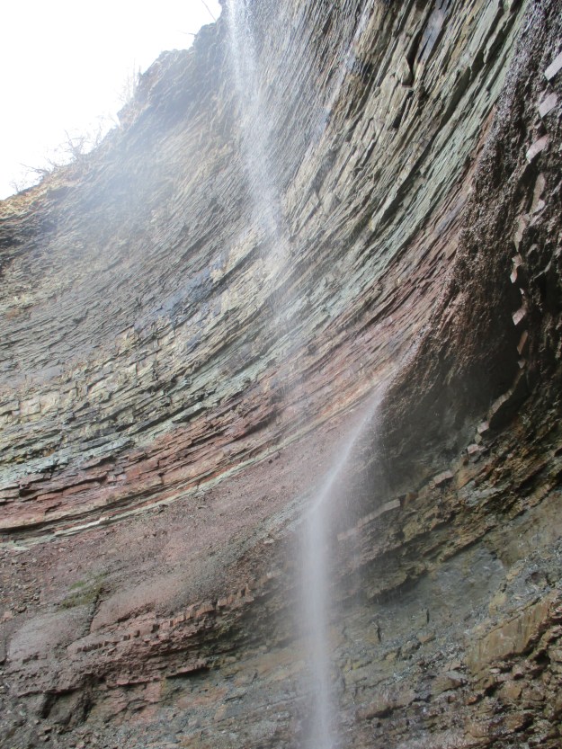
We followed the Robert MacLaren Side Trail along the top of the escarpment with the plan of taking the Chedoke Stairs back down to the Chedoke Rail Trail and from there to investigate a couple of local waterfalls.  From the trail you can see the top of Westcliffe Falls but the actual waterfall is hidden from view.  A little farther along you come to a spectacular view of Cliffview Falls.  The view from the top suggested that it would be worth the effort to follow the creek from the bottom of the escarpment back up to the bottom of the waterfall.

IMG_3040

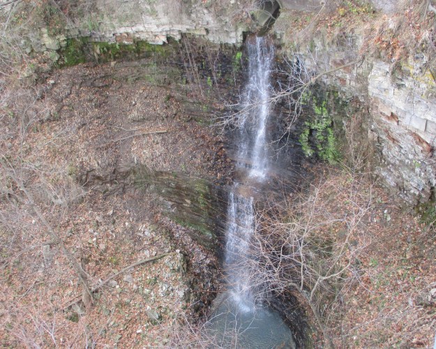
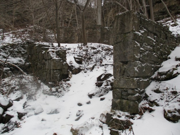
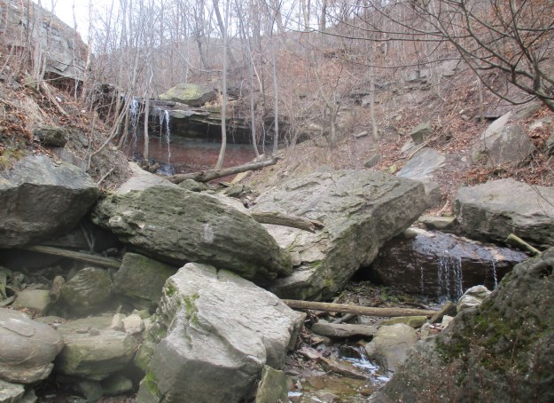
The waterfalls are located at the bottom of the Chedoke Stairs.   There are two waterfalls that meet near the bottom of the ravine and share a lower falls.  The Lower Cliffview Falls are on the left and Lower Westcliffe Falls on the right.

IMG_8534

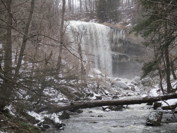
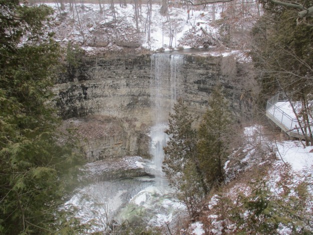
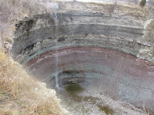
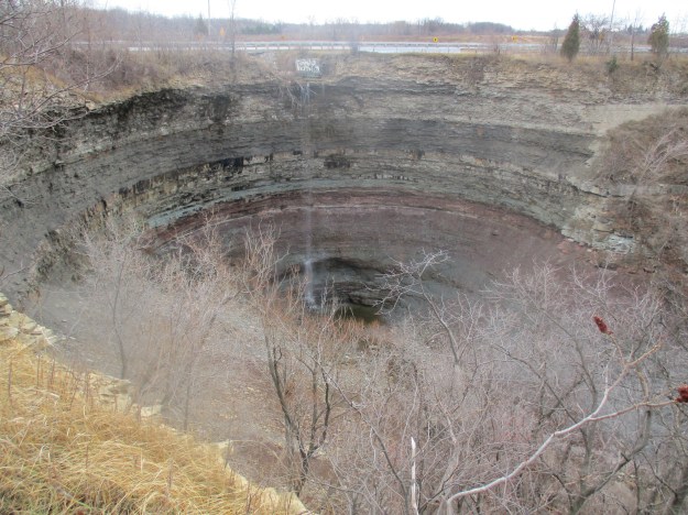
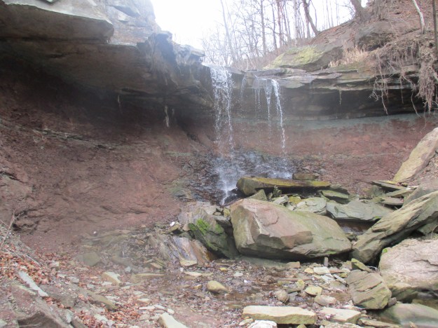
Westcliffe Falls is a 15-metre complex ribbon falls that is mostly hidden from the regular trails in the area.  However, you can climb past the lower falls and from there it is a short, easy climb to the main falls.  It is located in the ravine on the right above the combined lower falls.

IMG_8598

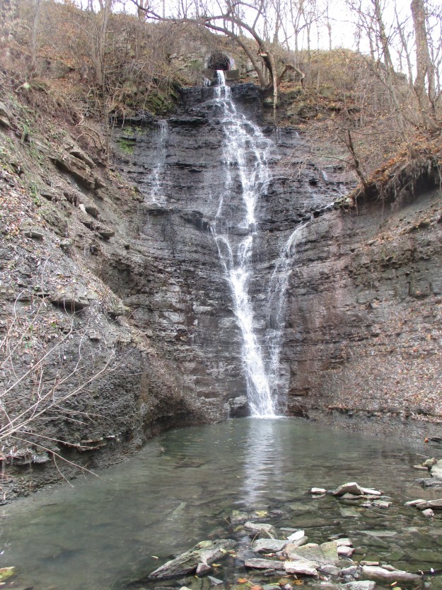
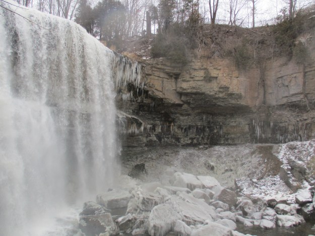
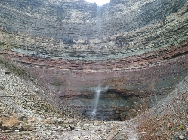
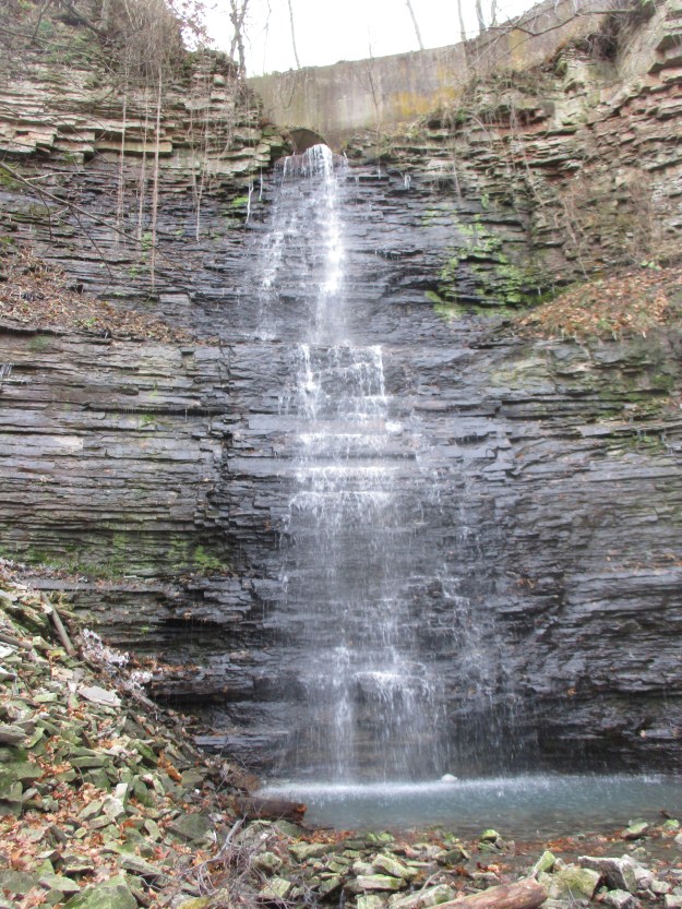
Cliffview Falls is 15 metres tall and is a terraced ribbon falls.  Both of these waterfalls are nice in spite of the low flow of water.  In the spring when the water is at its peak flow they are both likely to be quite spectacular, with Westcliffe being the more interesting of the two.

IMG_8603

Having climbed up the ravine to view the two sets of falls we returned to the car having fully enjoyed the day.

Further reading about local attractions near Chedoke Ski Hill:

Escarpment Stairs, Mountain Sanatorium, Chedoke Rail Trail

Google Maps Link: Chedoke Stairs 

Like us at http://www.facebook.com/hikingthegta

Follow us at http://www.hikingthegta.com

Follow us on Instagram

The Spencer Gorge – Webster’s and Tews Falls

Sat. Jan. 2, 2016

The Spencer Gorge is a Y-shaped cut in the escarpment that contains Tews Falls, a waterfall that may have rivaled Niagara Falls a few thousand years ago.  Webster’s Falls, seen in the cover photo, is found on the other arm of the Y.  To investigate the two of them we parked in Webster’s Falls Conservation Area.

Webster’s Falls is what is known as a classical plunge falls.  It drops 22 metres off of the Niagara Escarpment and has a width at the crest of 30 metres.  A plunge waterfall is one where the water loses contact with the surface of the bedrock due to it’s speed as it drops over the edge. They typically have deep pools at the bottom known as plunge pools.  A plunge waterfall where the water spreads out into a wider pool at the bottom is known as a punch bowl.  A local example of this is The Devil’s Punch Bowl.

IMG_2134

Joseph and Maria Webster emigrated from England in 1819 and bought the 78 acres of land surrounding what was then known as Dr. Hamilton’s Falls.  A small distillery and grist mill were operated by Joseph Jr., who expanded them in 1830 and again in 1842.  New owners George Harper and W.S. Merrill took over in 1891 and the mills were expanded for the last time.  Milling operations at the falls ended with a fire in 1898 which destroyed the buildings.

After the fire to the mills a new business venture was started.  George Harper turned to the idea of generating electricity.  It is said that he built one of Ontario’s first electrical generating plants at the base of the falls.  Harper’s power plant was able to turn on the street lights for January 27, 1899 and kept them supplied with power until the plant burned down in February 1901.  In actual fact The Barrie Light Company had predated Harper by over 10 years in providing light to Barrie in 1888. The picture below shows part of the old foundations at the base of the falls.

IMG_2226

The remaining structures were sold to the Cataract Power Company of Hamilton around this time.  An archive photo of the power plant as seen in 1910 is presented below.  The metal penstock that delivered water to the dynamo can be seen to the left of the falls.  It was removed before a subsequent shot of the falls was taken in 1920 by which time power was being delivered to the area from Niagara Falls.

IMG_2131

Some of the interesting features of the escarpment are the places where part of the geological column is exposed.  The escarpment was formed of sediment during a period of the earth’s history known as the Paleozoic era which included the Ordovician and Silurian periods.  At the escarpment top is the hard dolostone of the Lockport formation which formed along with the Rochester shale below it during the Silurian period more than 420 million years ago.  The Rochester shale is grey in colour and is a prime source of early marine fossils.  At Webster’s Falls this band is 2.5 metres thick and because of it’s relatively soft nature it erodes quickly leaving the dolostone on top undercut and ready to break away.  This can be clearly seen to the right of the falls where the shale is set back well below the dolomite.  The talus slopes below the Rochester shale are coated with ice from the mist of the falls.

IMG_2232

When Webster’s Falls was sold next in 1917 it became property of Dundas Public Utilities Commission who used it as part of their waterworks.  Originally known as Webster’s Falls Park the area was landscaped in the 1930’s and a cobblestone bridge constructed across Spencer Creek.  The bridge was restored in 2000 and the property became part of the Spencer Gorge Wilderness Area.

IMG_2206

The Webster family was buried on the property overlooking the Spencer Gorge and the creek below. Broken headstones have been collected into a small family plot where the pioneers are remembered.  Joseph Webster’s memorial stone is seen below.

IMG_2125

From Webster’s Falls a trail leads to Tews Falls and around to Dundas Peak.  We followed the trail to where we could see Logies Creek joining with Spencer Creek down in the valley below. Dundas Peak can be seen in the distance in this picture and it became the turning around point of our hike.  From this vantage point the city can be seen in the background and Tews Falls is in the gorge on the left while Webster’s is on the right.

IMG_2152

Tews Falls is known as a ribbon falls because the water flow is narrow compared to the rock face exposed around it.  Both Webster’s Falls and Tews Falls were formed at the end of the last ice age about 10,000 years ago when Spencer Gorge was forming.  Tews Falls flows over a distinct bowl shaped gorge that is actually the smallest of several bowls in the Spencer gorge. These get larger as one travels down the gorge until the final bowl is nearly as large as the one at Niagara Falls.  The height of Tews Falls is 41 metres while the Horseshoe Falls at Niagara is 52 metres.  Tews Falls is the highest waterfall in the Hamilton Area.  There is a Lower Tews Falls, just 3.7 metres high, which is just downstream from this one.

IMG_2169

In 1906 the falls were known as Hopkins Ravine after the family that owned the property at the time.  When the Tews bought it the falls took on their name.  The layers of shale and dolostone can be seen quite clearly at the falls where several lower formations are exposed that are hidden at Webster’s Falls.  The Rochester shale layer at Tews Falls is only 1.5 metres thick and can be seen just below the crest of the falls.

IMG_2165a

From Dundas Peak it is possible to see into Hamilton and Dundas.  There is also a spectacular view back up the Spencer Gorge with Spencer Creek flowing through the valley.  As we made our way along the edge of the gorge we were able to see many vistas that would be obscured by foliage during the summer months.

IMG_2181

On the way back from the peak we took the Glen Ferguson Side Trail which loops back to join with the Webster’s Falls Trail.  Along the way we surprised five white tailed deer.  They ran away as soon as they saw us revealing the original meaning behind the phrase “high-tailing it out of here”.

IMG_2184

Websters Falls is located at: 43.2764N 79.981W

Tews Falls is located at: 43.2815N 79.978W

Like us at http://www.facebook.com/hikingthegta

The Devil’s Punch Bowl

Saturday Dec. 26, 2015

The Devil’s Punch Bowl is a 37 metre gorge in the Niagara Escarpment near Stoney Creek where all the various strata of the Paleozoic era can be seen together.  Their colourful sequence along with a pair of waterfalls makes this a gorgeous gorge.  There is paid parking in the Devil’s Punch Bowl Conservation parking lot on Ridge Road in Hamilton.

The history of the Devil’s Punch Bowl name has been lost and all that remains are stories.  One of these stories suggests that moonshiners were working along the Ridge Road and would go into the falls to get pails of fresh water for their wares.  Regardless of the origin of the name it is just one of the local geological features that have been given devilish nomenclatures.  Two other ones are The Devil’s Pulpit and The Devil’s Well, all three of which are far more beautiful than their names suggest.  The history of the gorge is as old as the escarpment and it’s formation over 450 million years ago.  The colours seen in the rock show the various layers as they were laid down in a vast inland sea.  The bowl itself was formed at the end of an ice age a million years ago from the flow of melting ice caps.  The picture below shows the gorge looking away from the punch bowl and toward Hamilton.  A steel cross stands on the right side of the gorge where it has been lit since Dec. 18, 1966 when it replaced a wooden cross on the same location.  The Toronto skyline can be seen from near the cross.

IMG_2057

The picture below was taken from the top of the gorge where Stoney Creek plunges over the side.  Sometimes there’s a strong ribbon waterfall here but today the water level was very low.  The sides of the gorge have been filled with piles of talus which hides all but the upper rock layers. Over the years, erosion has broken rock debris off the sides of the gorge until it accumulates in sloping piles most of the way to the top. This makes decent of the sides impossible although I did notice the remains of rappelling anchors on the side of the old bridge abutment near where this photo was taken.

IMG_2067

The road passed much closer to the Punch Bowl a hundred years ago.  Half of the north bridge abutment has broken off and fallen toward the creek.  The other half has been defaced with graffiti.  The bridge is right on the brink of the falls which means that either people were more adventurous in the past or the cliff edge is eroding back with time.

IMG_2056

As you walk along the side of The Devil’s Punch Bowl you can see full depth of the gorge and the waterfall.  The cover photo also shows the concrete bridge abutment where the road used to pass closer to the gorge edge .  There are stories of people who have either jumped or fallen to their death in the punch bowl and it is important to keep back from the edge as it can give way at any time.

IMG_2080

We descended a blue side trail to reach the level of Stoney Creek so we could make our way back into the punch bowl.  The creek bed is littered with broken pieces of Whirlstone formation sandstone that have trees growing up between them.  Along the way, between the train tracks and the lower punch bowl, the creek cascades over several minor waterfalls.

IMG_2103

The lower punch bowl is 7 metres deep and 7 metres in diameter.  This second waterfall exposes another formation that is not visible in the upper punch bowl.  The harder sandstone of the Whirlpool formation sits on the bedrock of the Niagara Escarpment which is known as the Queenston Formation and is named after the town of Queenston.  The Queenston formation is made of maroon coloured shale that formed in slow moving waters in an area known as the Queenston Delta.  The red comes from oxidation of iron minerals and the grey-green layers contain shale that has gained an electron during oxidation in a process known as reduction.  This layer can be up to 300 metres thick and is often devoid of fossils.  The sandstone is harder than the shale and therefore it erodes slower leaving an overhang at the lower falls.  This shelf will eventually break off as can be seen by the sandstone chunks at the bottom of the falls.

IMG_2106

This is the same layer that is exposed at the Cheltenham Badlands where this picture was taken on July 4th, 2015.

IMG_6256

We passed the lower punch bowl and continued to climb the creek bed uphill.  As you enter the Devil’s Punch Bowl from the bottom you pass by sloping talus on both sides to emerge into the round inner bowl.  Even with only a limited waterfall the sight is incredible.  In the picture below a person is standing on talus to the left of the plunge pool at the bottom of the falls.  This gives some indication of the height of the gorge at this location. There are at least 10 distinct formations or layers that can be seen here.  The bottom visible layer is the Whirlpool formation which forms the upper shelf of the lower punch bowl falls.

Bowl

The capstone of the Niagara Escarpment is known as the Lockport formation and is a hard dolostone.  It has two distinct layers with the second being the first thin light line and below it is the softer Rochester Shale formation which is a darker grey band.  It appears near the top of the picture below.  A second thin light band of dolostone lies just below it.

IMG_2117a

This shale formation is known for it’s heavy concentration of marine fossils including many trilobites.  The picture below is not mine, unfortunately, but shows one of these fossils that was found in the same geological layer in New York State.

trilobite-arctinurus-boltoni-2_pinboarditemoverlay

The waterfall bounces off of the reddish layer known as the Grimsby formation.  Directly above it is a grey-green layer known as the Thorold formation.  These two sections, and specifically the contact point between them, provide much of Ontario’s gas production along Lake Erie.

IMG_2115

We followed a blue side trail which runs along the the north side of the gorge and links back to Ridge Road.  Along the side of the trail stand the foundations for a former building which had a grand view of the Devil’s Punch Bowl.

IMG_2121

As we returned to the car we took a minute to investigate the start of the Dofasco 2000 trail which is right across the street from the parking lot.  This 11.5 kilometer trail will connect to Battlefield House where the Battle of Stoney Creek took place on June 6, 1813.  We only went a short distance where runs through what appears to be an abandoned Christmas Tree farm. This trail offers a potential future exploration.

IMG_2055

The Devil’s Punch Bowl can be found at N43.21045 W79.75594

Like us at http://www.facebook.com/hikingthegta