
Sunday June 12, 2016
When the train left Markdale on Sep. 3, 1907 making a special run to the Exhibition in Toronto everyone anticipated a day of fun and not the horror that would leave 7 dead and 114 injured.
Railway construction in Canada in the 1850’s was expensive due to grand stone bridges and stations built to elegant standards. However, traffic was light and many early railways struggled to stay in business. A recession and the American Civil War meant that there was almost no railway construction in the 1860’s. After Confederation in 1867 a desire to open up the northern counties led to a plan to build cheap railways into the interior of the province of Ontario. The Toronto Grey & Bruce Railway was chartered in 1868 to build a line from Toronto to Grey and Bruce counties. To keep costs down a narrow gauge track was built. It was opened to Orangeville in 1871 and ran 3 trains daily. When extended to Owen Sound it would run only 2 that far each day. Construction required 3 major bridges over the Humber River, the Grand River and the Saugeen River. Another major obstacle was the ascent of the Niagara Escarpment near Caledon. This was accomplished by means of an 11 and 12 degree curve with a 462 foot radius known as The Horseshoe Curve just north of Cardwell. Unfortunately, the choice of a narrow gauge made freight transport uneconomical because cars couldn’t be switched between tracks and had to be off loaded and reloaded onto other cars for further transport. The line was in trouble from the beginning being unable to cope with the freight load. The Grand Trunk Railway (GTR) bought them in 1881 and converted the track to a standard gauge. The GTR couldn’t finance the gauge conversion and lost control to the Ontario & Quebec Railway (CPR) in 1883.
The Toronto Industrial Exhibition opened in 1879 as an annual fair to showcase industry and agriculture. The fair changed it’s name to the Canadian National Exhibition in 1912 to reflect the national scale of the exhibition. Railways were always looking for new ways to generate revenue and providing transportation to entertainment sites such as Eldorado Park was part of their marketing strategy. Five different rail lines offered special rates and added services to bring people to the Exhibition. One of these excursions left Markdale at 7:34 am on Tuesday September 3, 1907 with a return fare of just $1.55. Engine 555 had spent the night in Owen Sound where the crew had gone to use the turntable to turn the train around for the return trip to Toronto. The big Ten-Wheeler (4-6-0) left Owen Sound at 3:20 am arriving in Shelburne at 8:25, nearly an hour and a half behind schedule. The crew appear to have been trying to make up time because when they reached Orangeville 2 men got off saying they worried the train would be wrecked because of the speed it was going.
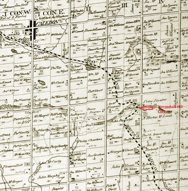
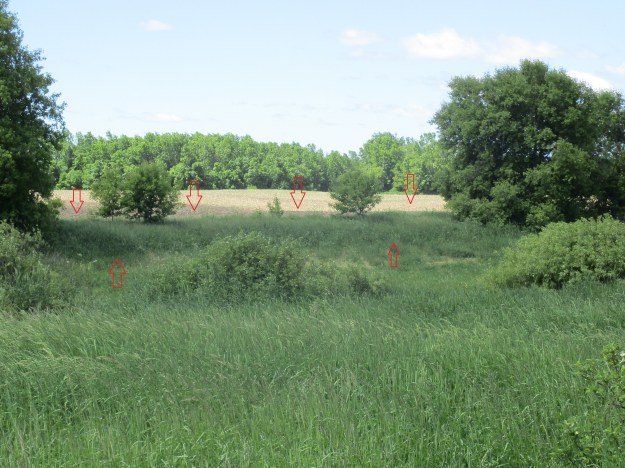
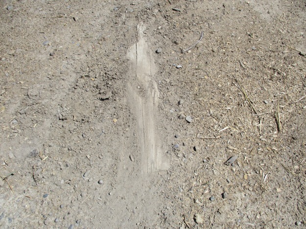
It was standing room only in the five coaches and so two more were added in Orangeville before it left there at 9:00 am with about 600 people on board. South of Caledon the train started it’s descent of the escarpment, known locally as Caledon Mountain, where it passed a Slow Board with a speed limit of 25 mph posted for the upcoming curve. Twenty-three year old George Hodge was at the helm and he claimed he never saw the sign. Perhaps that is because he was driving at up to 60 mph and the sign was a blur to him. The rail line can be seen on the map above as it leaves the town of Caledon. The rail line runs along the west side of modern Heart Lake Road. In the picture below it can be seen as a berm in the field. I’ve marked it with red arrows for clarity.
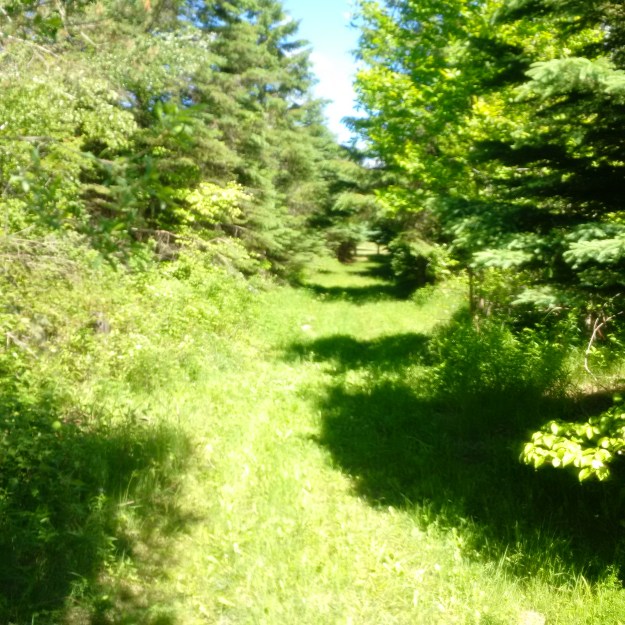
This is the view of the Toronto Grey & Bruce Railway line looking north from Escarpment Sideroad.
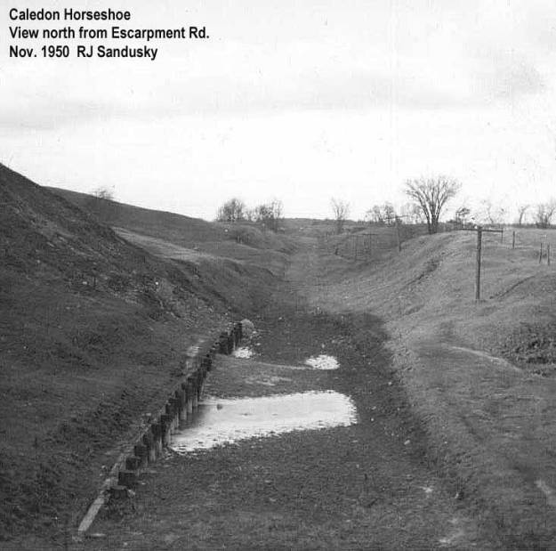
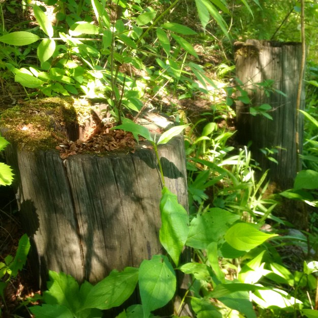
The 1950 archive photo below shows the same vantage point 66 years ago. Steam railways kept the trees and vegetation trimmed for the full width of the right-of-way to help prevent sparks from starting fires.
The wooden crib that supports the embankment has been almost lost behind a new growth of vegetation.
The rail line has been abandoned since 1932 and the rails were removed for use during World War 2. The ravine where the tracks crossed Escarpment Sideroad has been filled in to reduce the grade for cars on the road but the rail corridor continues on the south side. Most of the ties have also been removed but there are still some where the line curved to head east toward the Horseshoe Curve.
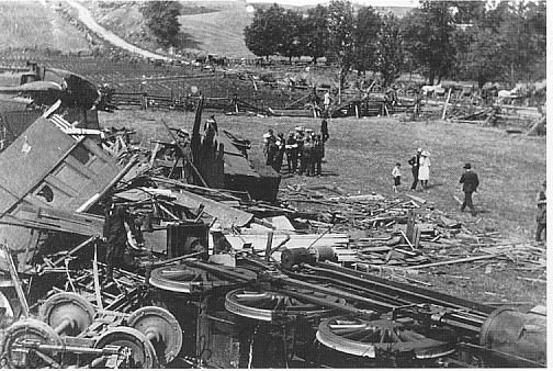
The Horseshoe was designed to allow the locomotives to climb or descend the escarpment. Between mile 38 and mile 37 on the line the elevation drops from 1050 feet to 965 feet in a grade of 2%. That morning as the passenger train entered the curve on the horseshoe, which can be seen in the cover photo, it left the tracks. Five of the seven coaches ended up in the ditch and four of them were destroyed. Seven people were killed and 114 injured in the worst rail disaster in this part of the province. The picture below shows the wreckage with Horseshoe Hill Road in the background.
The passengers never completed their excursion to the Exhibition that day because they didn’t make it safely down off of the Niagara Escarpment. The view from beside the Horseshoe Curve allows you to see the CN Tower on a clear day. The Exhibition is located near the base of the CN Tower.

Helmsman George Hodge and Conductor Matthew Grimes were arrested and charged with criminal negligence. At the trial Hodge claimed to have been doing only 15 miles per hour. It turned out that Hodge had driven his first passenger train the day before when he left Parkdale in Toronto with this very train. Speculation included hungover or sleeping crew members but in the end they were found not guilty. The CPR was found guilty of not providing competent crew members and they ended up paying off the survivors for years afterward. Canada Hawkweed, pictured below, has flowers which are similar to common dandelion. The leaves have toothed margins and can almost appear to be hooked over.

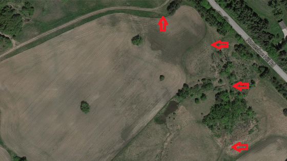
The Horseshoe Curve is still visible in this Google Maps image. 
The former Toronto Grey & Bruce Railway can be seen from the Bruce Trail where the Bruce follows Escarpment Sideroad.
Google Map link: Horseshoe Hill Curve
Like us at http://www.facebook.com/hikingthegta
Follow us at http://www.hikingthegta.com

Interesting read and pics. Thanks
good read
The part about CPR acquiring GTR is False. The GTR had some interest to buy the TG&B when the gauge was changed but was forced to withdraw and the TG&B was sold to the Ontario & Quebec Rwy. owned by the CPR.
On-line sources such as Wikipedia (not entirely reliable) show the GTR had control from 1881-1883. Do you have a source that shows they did not? That would be interesting.
Pingback: Hiking the GTA #200 – Greatest Treks 2 | Hiking the GTA
Pingback: Cardwell Junction | Hiking the GTA
Pingback: Melville | Hiking the GTA
Great history and pics…love steam railroad information.
Ranger
Pingback: All-Time Top Trails (So far…) | Hiking the GTA
If you want to see good evidence of the old TGB line, walk along the green belt rail line trail wealth of Caledon East, between St. Andrews Rd and Mountainview, you can see the junction stone bridge supports.
I don’t think I’ve ever seen such a superb job of research, writing and photography. One can spend a lot of time on the internet and never have such an engrossing experience as one can have right here!
I thought I knew this bit of country (I’m from Sandhill) as I drove my Beetle and flew my Cessna all over as a kid, but I never heard of Melville until now.
Thank you Derrick!
I am interested in hiking the curve. I understand that it is private land. Is it possible to hike the curve? I ask as this is a hiking site.
You can trace the old line on Google Earth and still see the curve outline in a farmers field SW of the Horseshoe Hill and Escarpment Rd. Intersection. I think you would have to knock on some doors and ask permission. I have a metal detector and have thought it might be interesting to see what is there….although digging would hurt the crop. I think the line was removed @ 1950.
Great site. Yes, the Horseshoe Curve lands are private property. The Toronto Grey & Bruce Rly built the line through this area as a narrow gauge railway in 1871. It reached aowen Sound in 1873. A controlling interest was obtained by the Grand Trunk Railway and it was standard-gauged in December, 1881. The GTR over-extended itself and the line was acquired by the aontario & Quebec Rly in 1884 – which was essentially owned by Canadian Pacific.
The line between Bolton Jct and Melville Jct, which included the ahorseshoe Curve, was abandoned in July 1931, and the rails removed in May 1933.
Pingback: West Toronto Railpath | Hiking the GTA
Pingback: Back Tracks – 8 Years of Trails | Hiking the GTA
Had never heard of this tragedy until reading your article. My grandparents lived in Markdale from 1905 until their deaths in 1960- at 88 and 89 years of age. People didn’t seem to speak of such tragedies then, certainly not in the presence of children. I was only 10 years old when they passed away. Thank-you for this piece of history. My father, Cosby James Bowes and his sister, Helen Bowes Lucas were born in 1907 and 1908.
Enjoyed this information immensely. My great grandfather William John Hyde worked for the T G And B by census data. I’m always interested in learning more about that railroad and it’s history. Can anyone give information on further reading? Thanks
Rod Clarke wrote a BIIIIIIG book (literally) entitled “Narrow Gauge Through The Bush” that is a history of this line and its sister Toronto & Nipissing Rly.
Photos of the original narrow gauge line 1870-1881 are very rare and we’d be interested if you had any old photos etc of it.
Pingback: Credit Valley Railway Station – Streetsville | Hiking the GTA