Thursday May 12, 2016
The Culham Trail currently extends for 14.4 kilometers but is broken in three sections. When finished, it will be 18 kilometers long and run from Erindale Park north to the border of Brampton. It is named after David J Culham who was a city councillor from 1973 until 2000. He is known for his work with both the Toronto Region Conservation Authority and the Credit Valley Conservation Authority. The trail starts at the site of the Erindale power generating dam and runs past mill sites, homesteads and old farms, the Streetsville power generating plant and into historic Meadowvale.
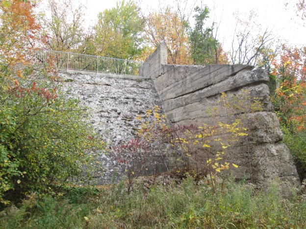
The southern section runs north from Dundas Street at Erindale Park. In 1902 Erindale Light and Power Company was formed to construct an hydro electric generating plant on the Credit River at Erindale. This large scale engineering project ran into several delays during construction and didn’t begin producing power until 1910. A dam was constructed across the valley flooding it and creating the 125 acre Lake Erindale. A power generating plant was built on the south end of town at the bottom of Proudfoot Street. A tunnel was constructed to connect the two. The power plant operated from 1910 until 1923 supplying power to Erindale and New Toronto. It was closed when Ontario Hydro began to supply the area with power from Niagara Falls. In 1941 the lake was drained and the dam was blown up. Between 1961 and 1965 the former lake bottom was used as a sanitary landfill. It has since been covered over with clean soil and Erindale Park has been created. The picture below shows the intake where water was taken from the lake and under Dundas Street. The Erindale Hydro Electric Dam and surrounding area was explored on Oct. 19, 2014.
The trail follows the east side of the Credit River north to Burnhamthorpe and then into the former Riverwood Estate. In 1913 W. R. Percy and Ida Parker purchased 150 acres of land on which to build their estate. In 1918 Percy commissioned the building of a new home on the property to be called Riverwood. It was built of stone which was hauled up from the river on the lane way past the stone cottage. The main part of the building, behind the grand fireplace, was a large party room. Several Canadian Prime Ministers are said to have frequented the home. William Lyon Mackenzie King visited here often during his 22 years as Prime Minister. This was also one of the first homes in Toronto Township to have electricity. The property also featured the first swimming pool in what would become Mississauga.
The Riverwood estate was sold off into three lots. The south portion became known is the Bird Property and has the remnants of a 19th century pickle factory on it. The northern section was sold to the Zaichuk family and contains many artifacts from it’s farming past. The trail then leads under the 403 and into Hewick’s Meadows. The Hewicks farm has been replaced with a subdivision and the 403. The trail leaves the river here and follows the road through the Hewicks property. A bike park has been set up along the power corridor that runs parallel to the highway and can be seen below.
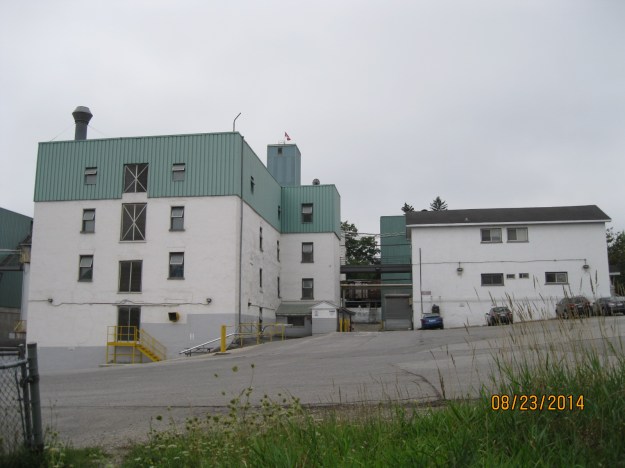
There is a trail that descends to the river level and follows it toward to where it connects again with the formal trail in the lower meadows. This field was barren of trees but is now becoming overgrown. It is common to see white tail deer in this field at dusk or dawn. Continuing north, Culham Trail passes under Eglinton Avenue and into Barbertown. In 1843 the Barber Brothers, William and Robert, decided to expand their Georgetown mill operation by buying William Comfort’s farm and mill site just south of Streetsville. In 1852 they built a 4 story woollen mill. When it burned in 1861 their workers just built a new one and opened again only three months later. Within 10 years it was the fourth largest textile mill in Ontario. During the first world war it was converted to a flour mill which it continues as today. This second mill remains on the left in the photo below but has been covered over with stucco and aluminum siding.
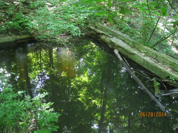
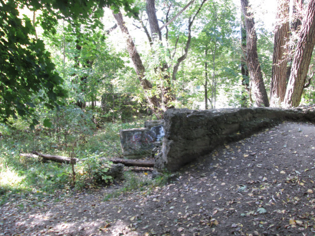
There is a break in the trail between Barbertown and Streetsville. Culham Trail picks up again in Streetsville. North of Bristol Road the trails follows the east side of the river. Soon it passes an odd set of concrete foundations that seem lost to the historical record. There is a possibility that they were a part of the Guelph Radial Railway.
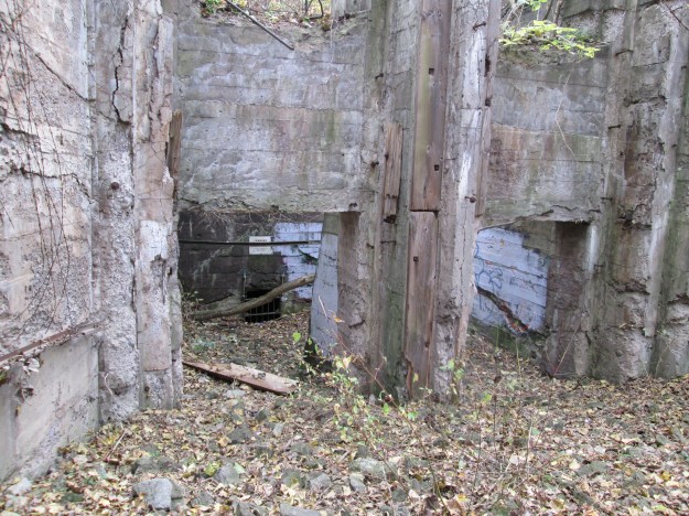
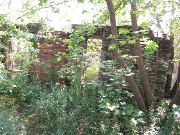
On the opposite side of the river as you travel north you will see the remains of Streetville’s Hydro Electric generating plant also known as Hyde’s Mill. Heman and Mary Hyde ran a large inn at Church and Main street for 40 years and this, along with proceeds from their saw mill, placed them among the wealthy in early Streetsville. Their son, John “Church” Hyde, built his own little merchant-miller empire. By 1840 he had built a mill on the west side of the river near the end of Church street. The mill expanded into a saw and grist mill, cooperage and stave factory. Staves are the thin wood boards which were used by a cooper to make barrels. He also built quarters for his workers at the mill site. In 1906 the mill was converted to produce hydro electricity for the town of Streetsville. It was Ontario’s first municipally owned power plant. The plant continued to be the source for power for the town until 1943 when Streetsville joined Ontario Hydro. The plant continued to provide auxiliary power until 1960 when it was shut down.
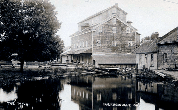
A third section of trail exists in Meadowvale and runs through the conservation area there. Meadowvale grew up around the Silverthorne grist mill and the remains of the mill form a park in town. Meadowvale has a high number of heritage buildings and has been designated as a cultural heritage centre.
The Culham Trail will one day be linked together to form a continuous trail through Mississauga. Parts of it will also be used to form the Credit Valley Trail when it is completed to Island Lake in Orangeville.
Check out this recent feature of some popular hikes.
Culham Trail Map (The trail is marked in purple)
Getting there by Mississauga Transit: routes 101 on Dundas, 9 or 35 on Eglinton, 9 at Memorial Park, 10 on Britannia, 42 on Old Derry Road.
Like us at http://www.facebook.com/hikingthegta
Follow us at http://www.hikingthegta.com

Pingback: Streetsville’s Forgotten Foundations | Hiking the GTA
Pingback: Culham Trail – Eglinton to Burnhamthorpe | Hiking the GTA
Pingback: Streetsville – Timothy Street | Hiking the GTA
Pingback: Timothy Street – Pioneers of the GTA | Hiking the GTA
Pingback: Riverwood – Armstrong Wild Bird Trek | Hiking the GTA
Pingback: Back Tracks – 8 Years of Trails | Hiking the GTA