Category Archives: Historic Site

Uxbridge Historical Centre

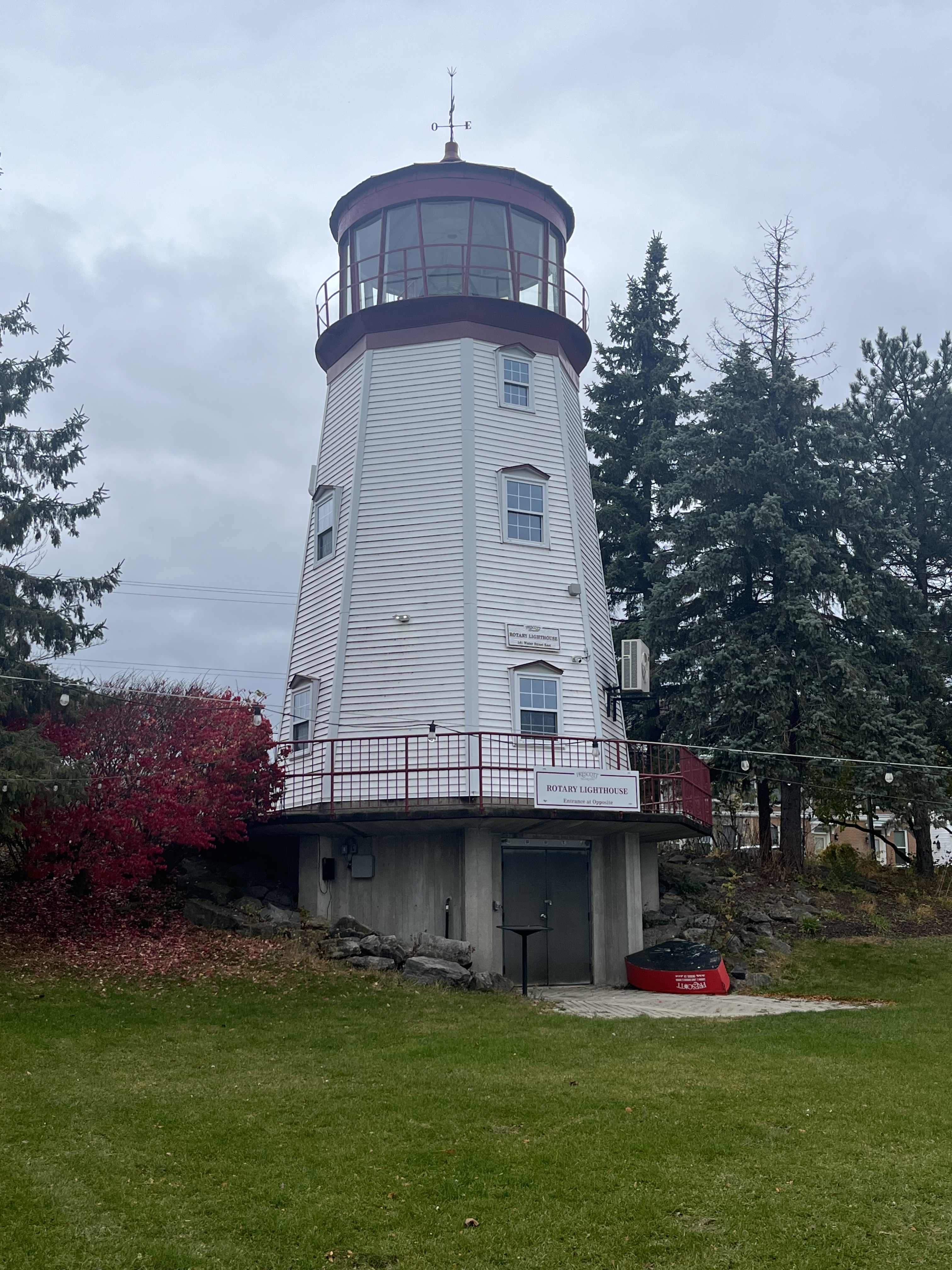
Saturday, March 9, 2024

The Uxbridge Historical Centre was founded in 1972 and was created around the Quaker Hill school house. It is home to ten buildings and a large number of artifacts that combine to tell the local history of the township and the town of Uxbridge.

When Uxbridge township was opened up for settlement a lot of the early pioneers were Quakers. These members of The Society of Friends came from Pennsylvania along the newly created Yonge Street. Twelve families started to carve out a new life for themselves in 1804. Soon they started to make plans to build a Meeting House for themselves. In 1809 they built their first Meeting House out of logs and replaced it with a frame building in 1820. This was the only church in the township for nearly a generation. Meetings were held in this building until 1925 and it holds the distinction of being the oldest building in Uxbridge Township.

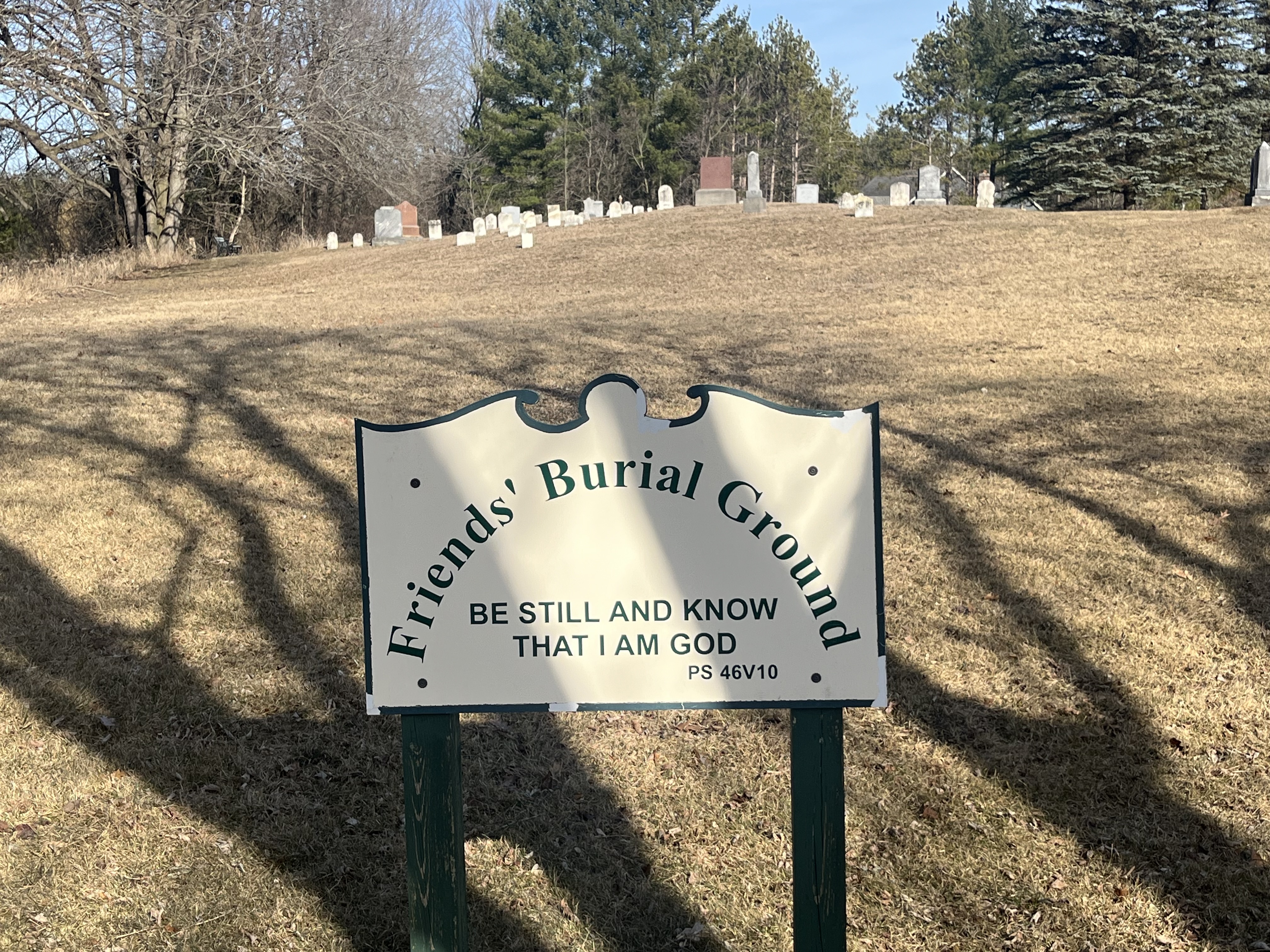
At the same time as they built the first Meeting House they acquired the plot across the road for a cemetery. This was the only cemetery in the area for a decade and has some early grave markers made from local granite.

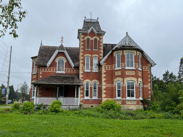
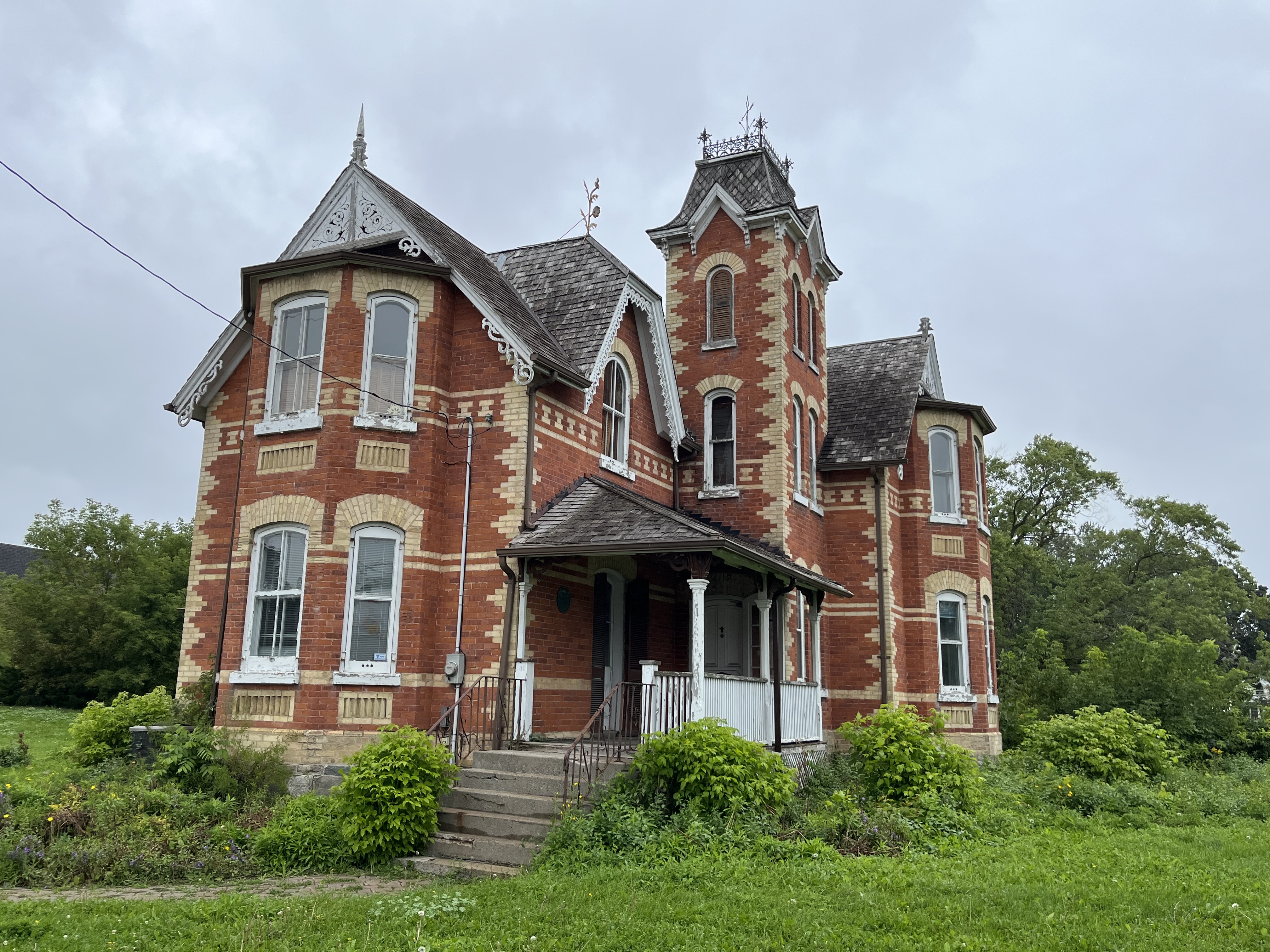
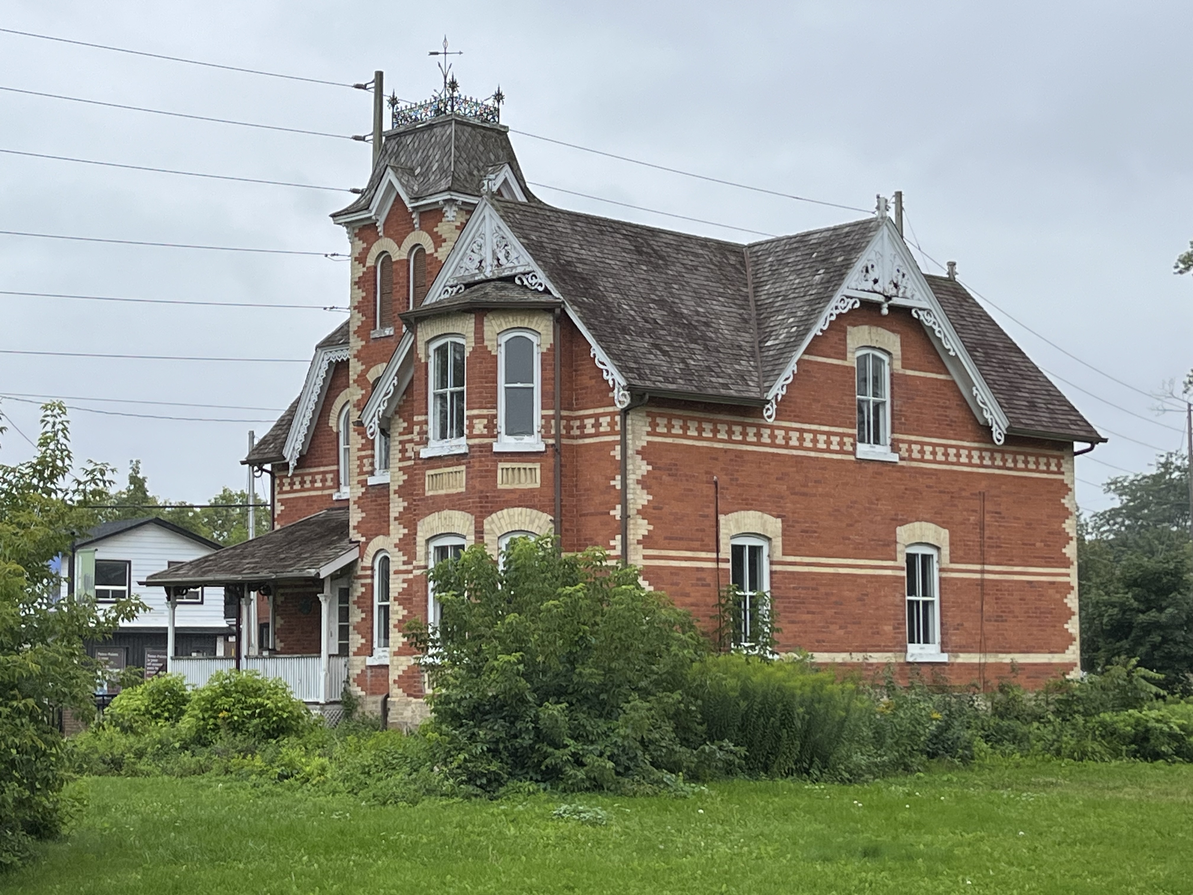
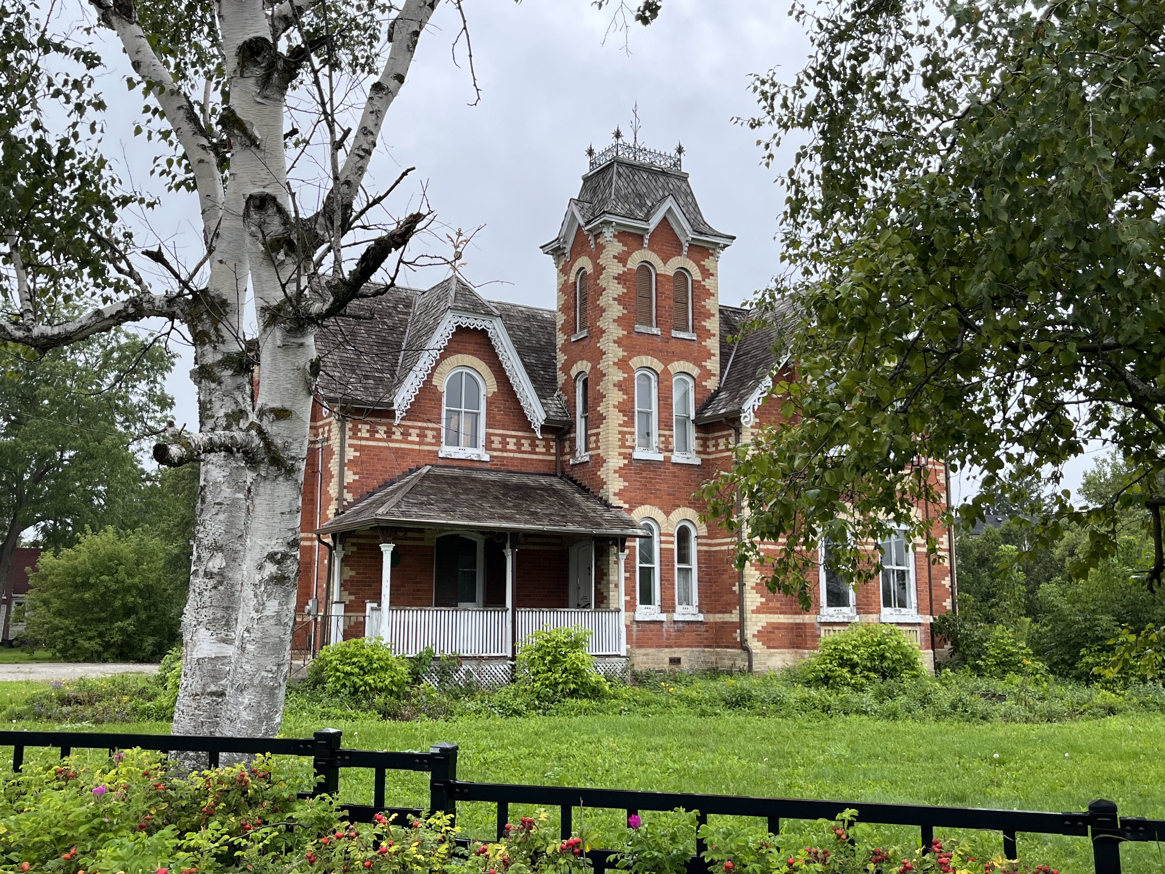
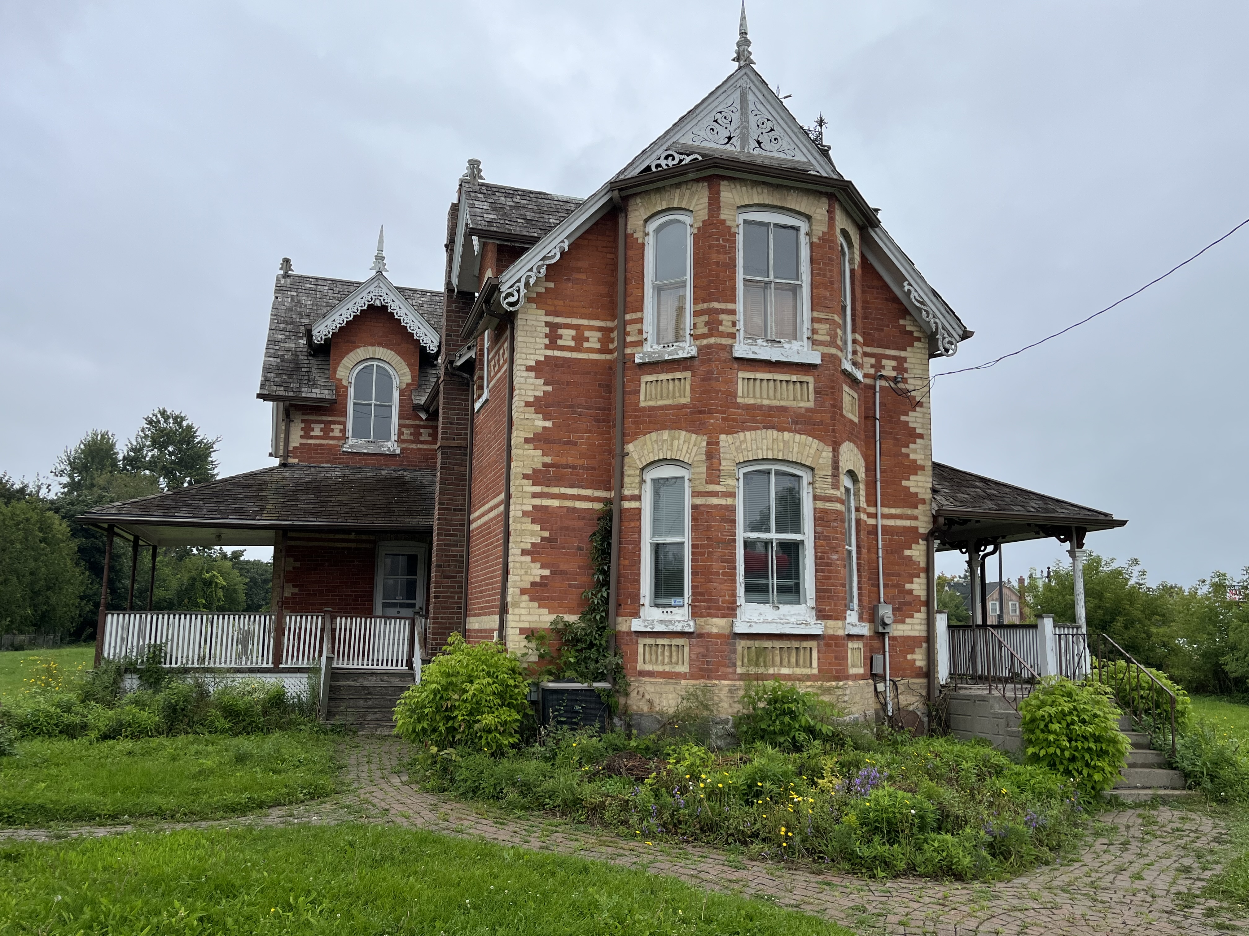
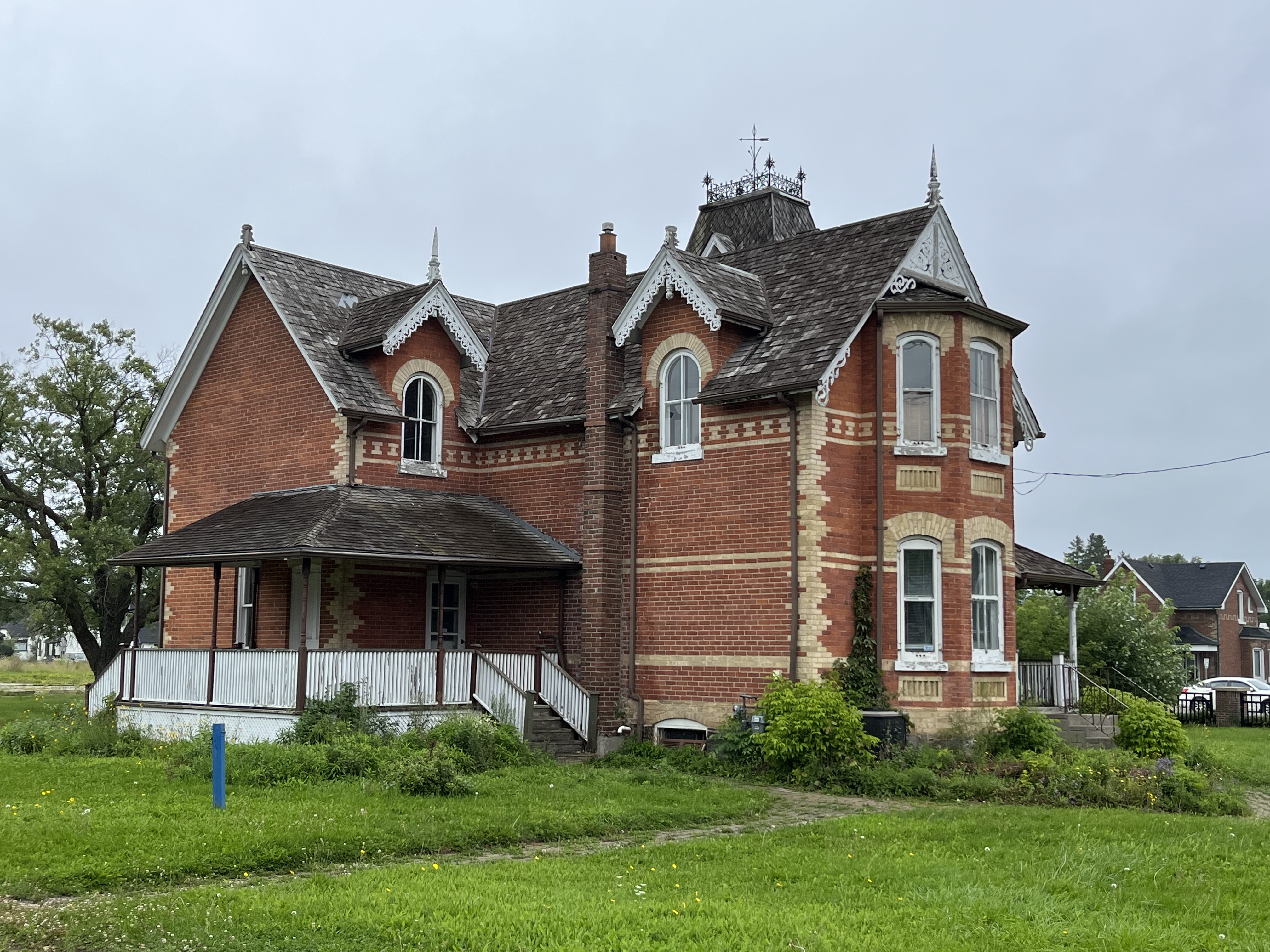
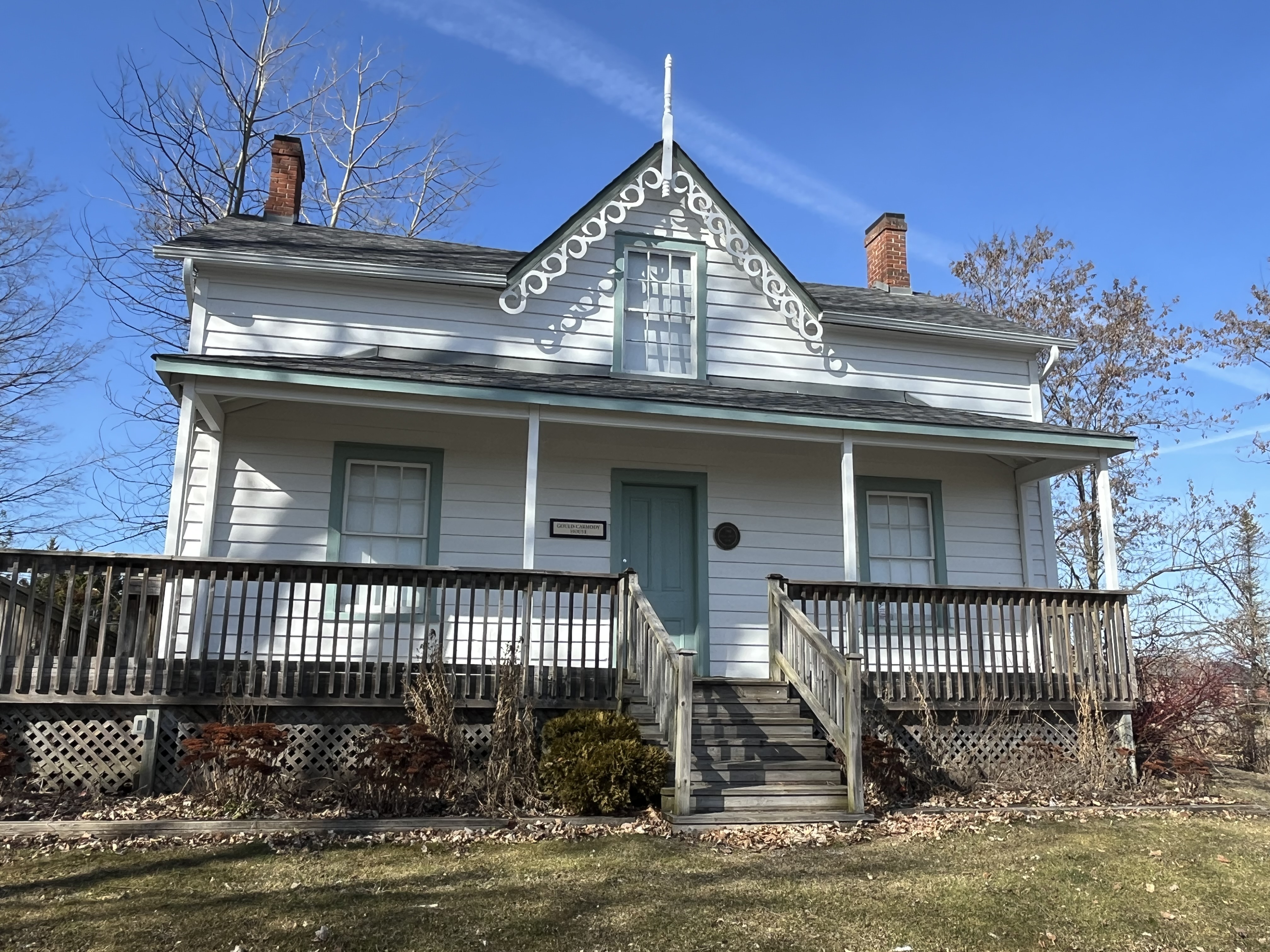
The home known as the Gould-Carmody house was built in the late 1850s in the area of town that currently is home to the arena. It was built by Joseph Gould who was the first local MPP. He was very influential in the development of the town of Uxbridge. His family sold the home to William Carmody in 1914 and it was moved to its present site in 1988. The decorative bargeboard, or gingerbread, along with the finial at the peak, give the home a distinctive appearance.

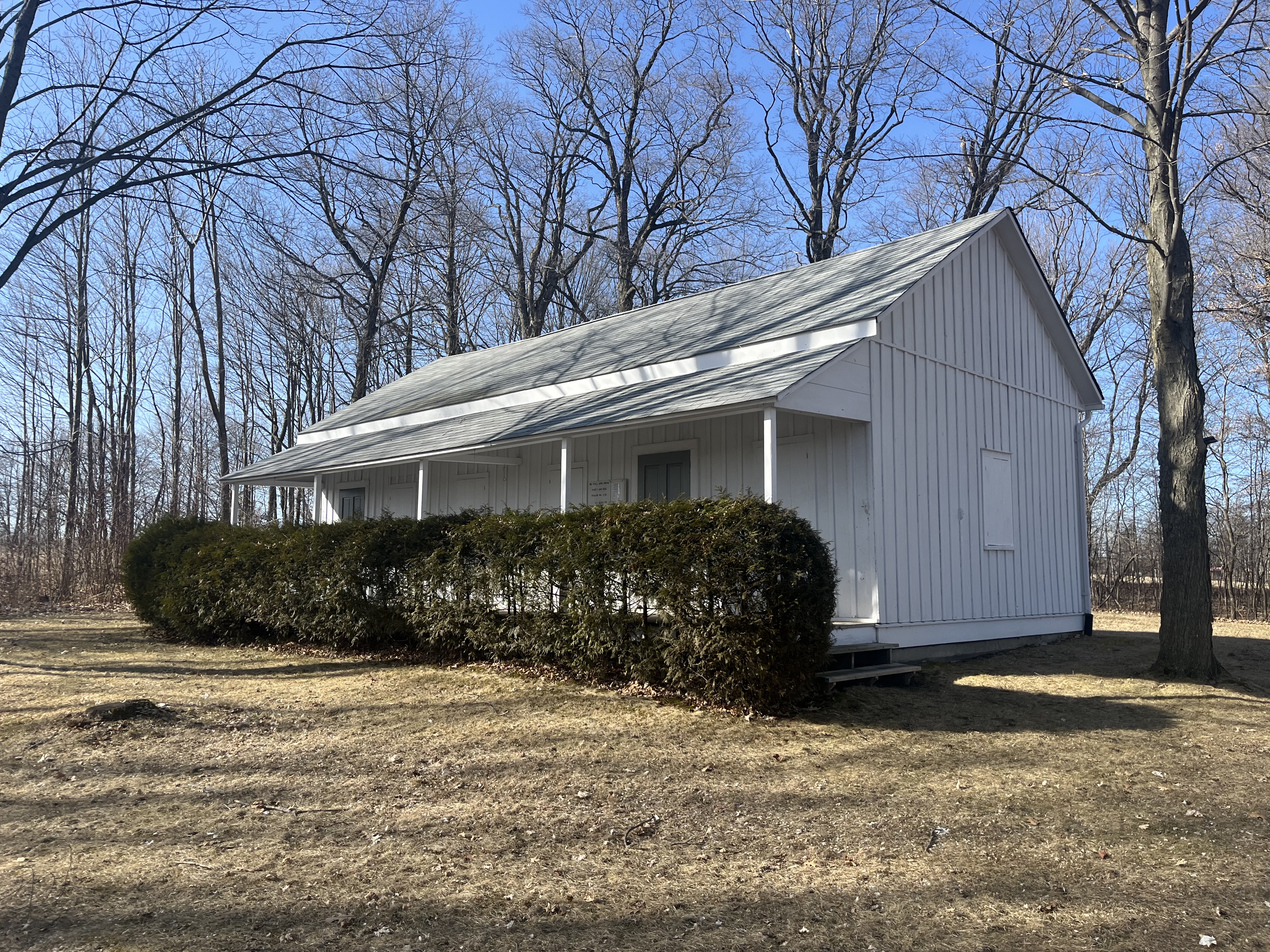
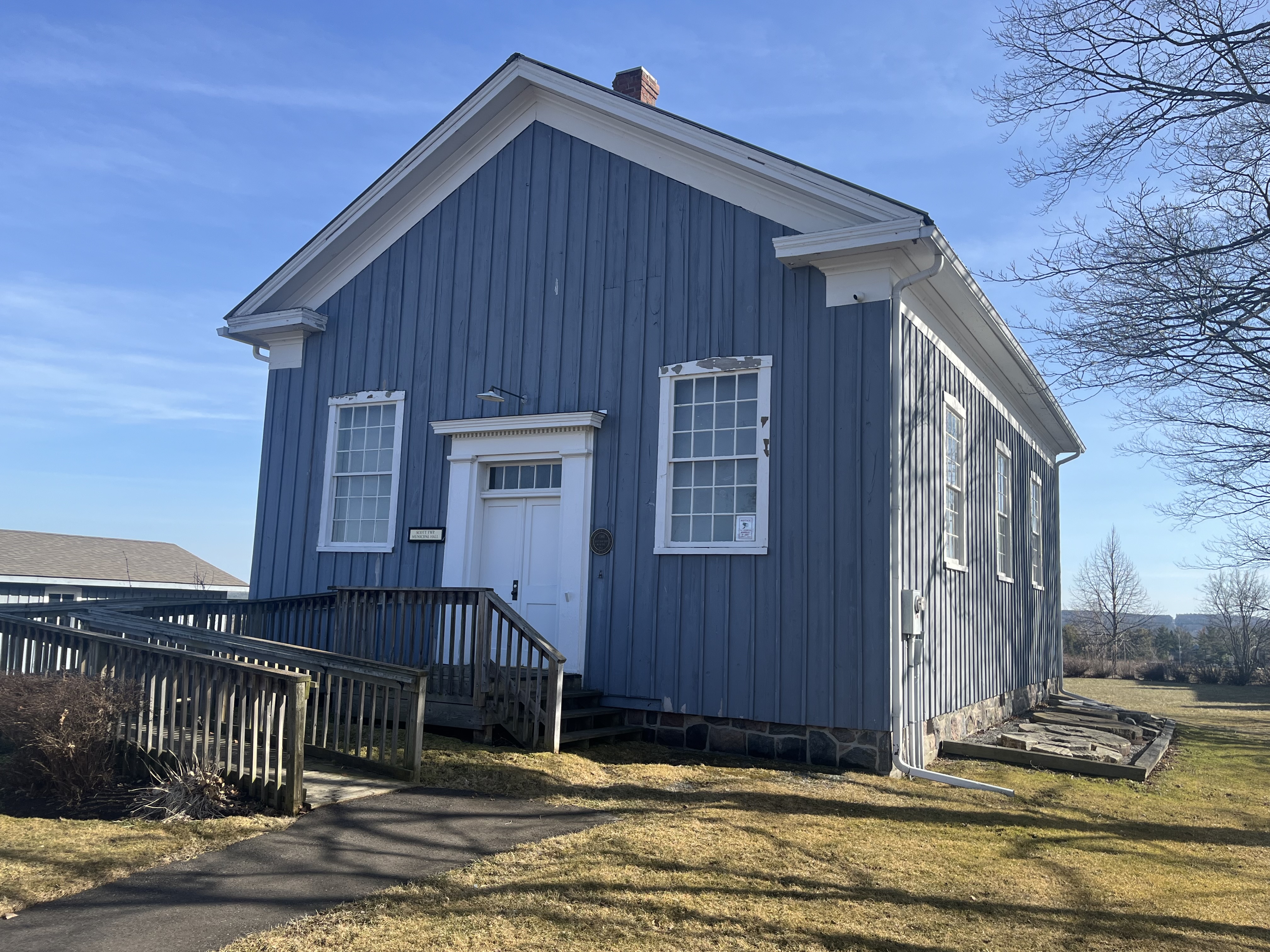
The Scott Township Municipal Hall was built in 1860 and served the town council until 1967. After this time, the wood frame building was moved to the farm of Ed and Dorothy Brown and used as a Country Heritage Museum. It was moved to the Uxbridge Historical Centre in 1993. The front entrance has windows on either side which contain 12 over 12 window sashes. The door itself is modest but has pilasters on either side and a lighted transom over the top.

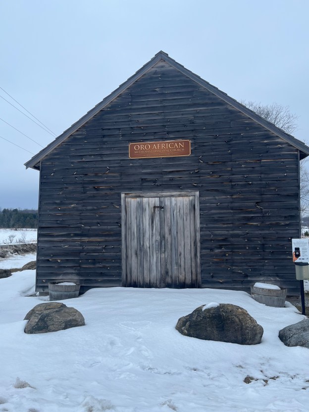
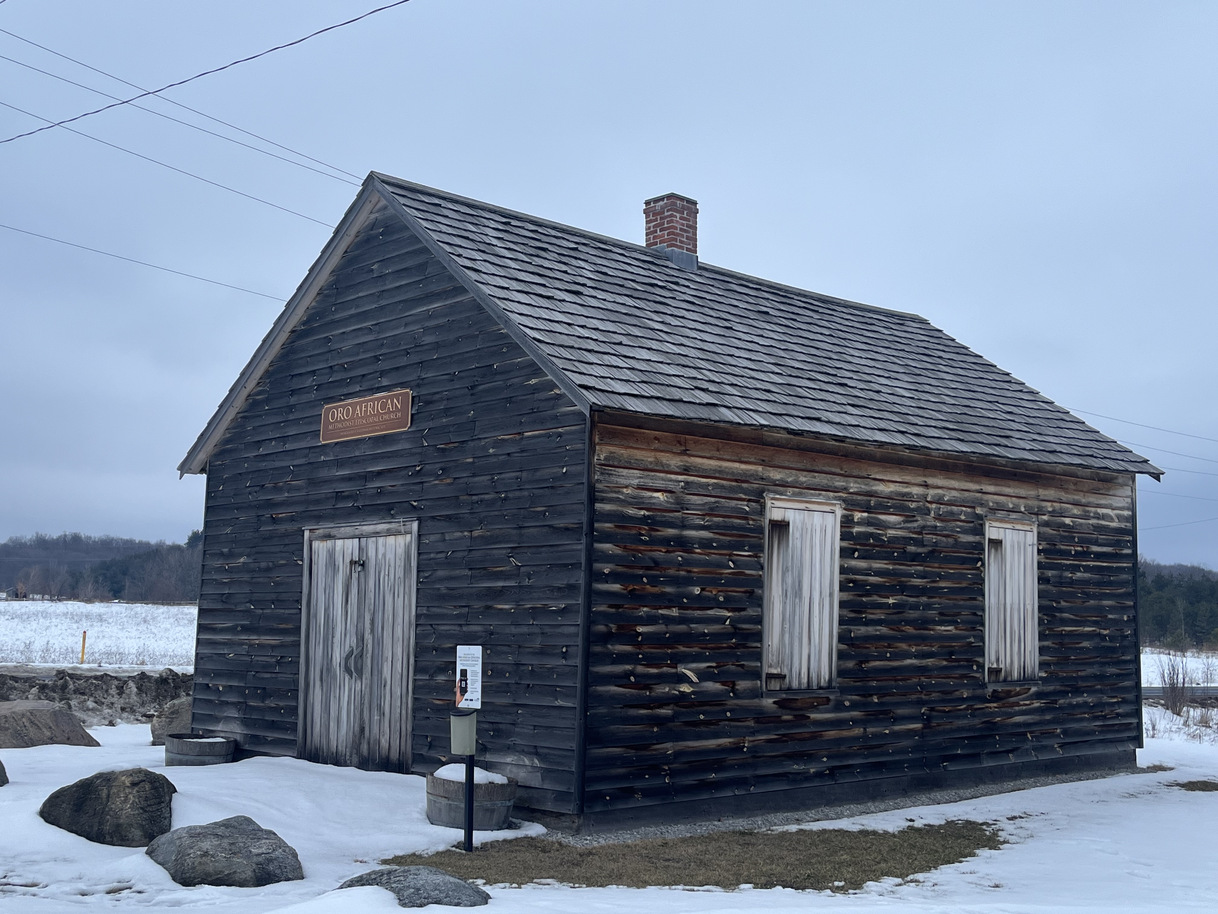
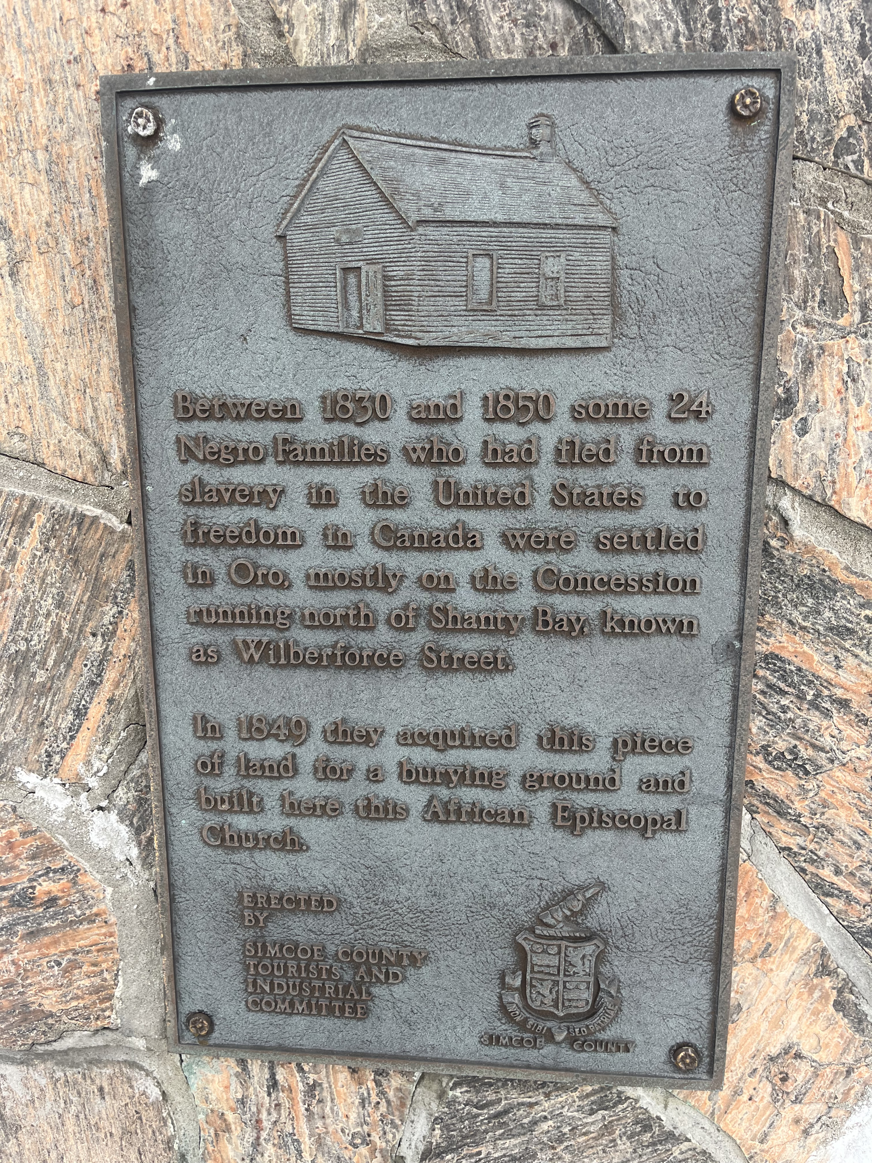
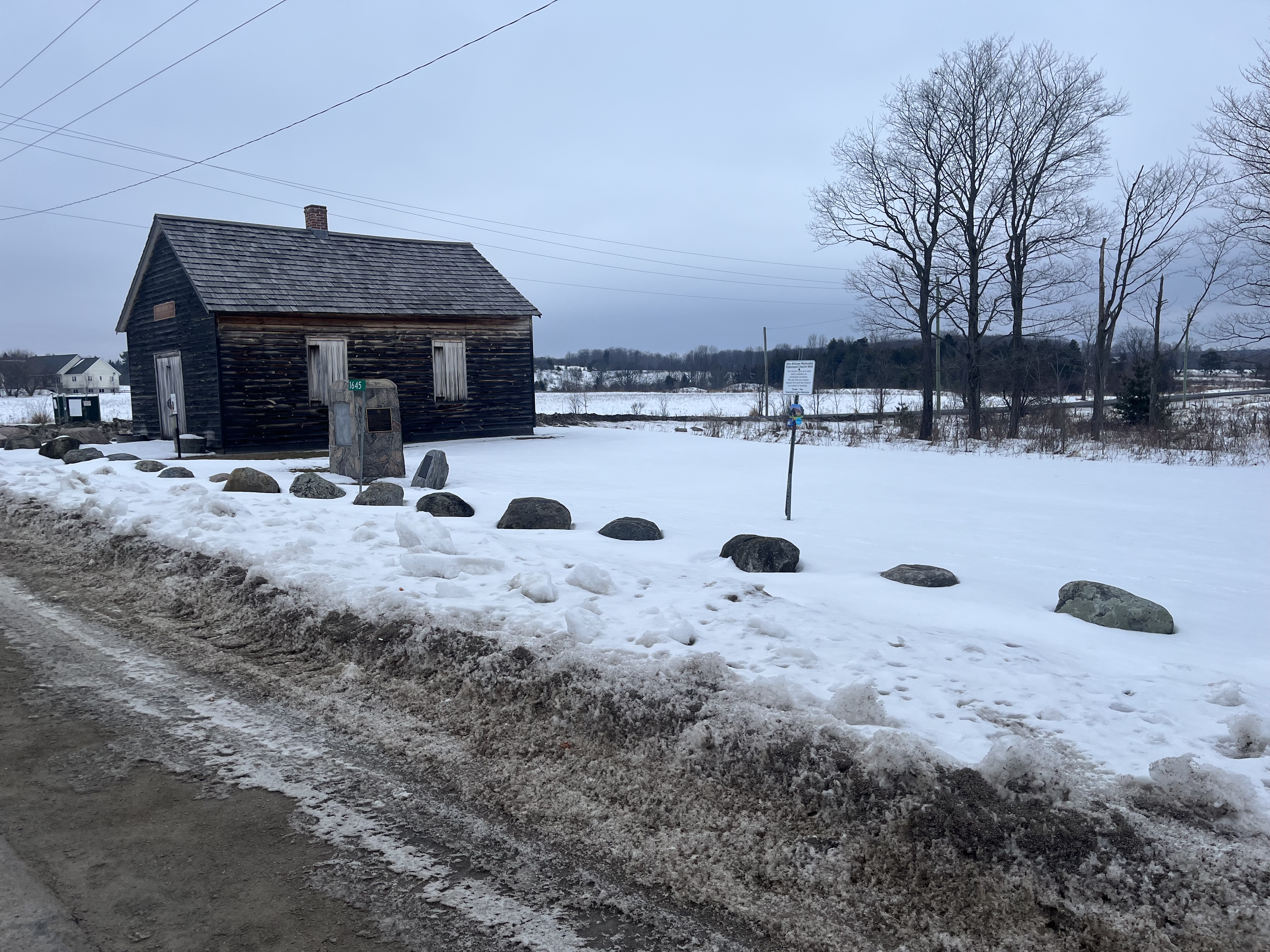
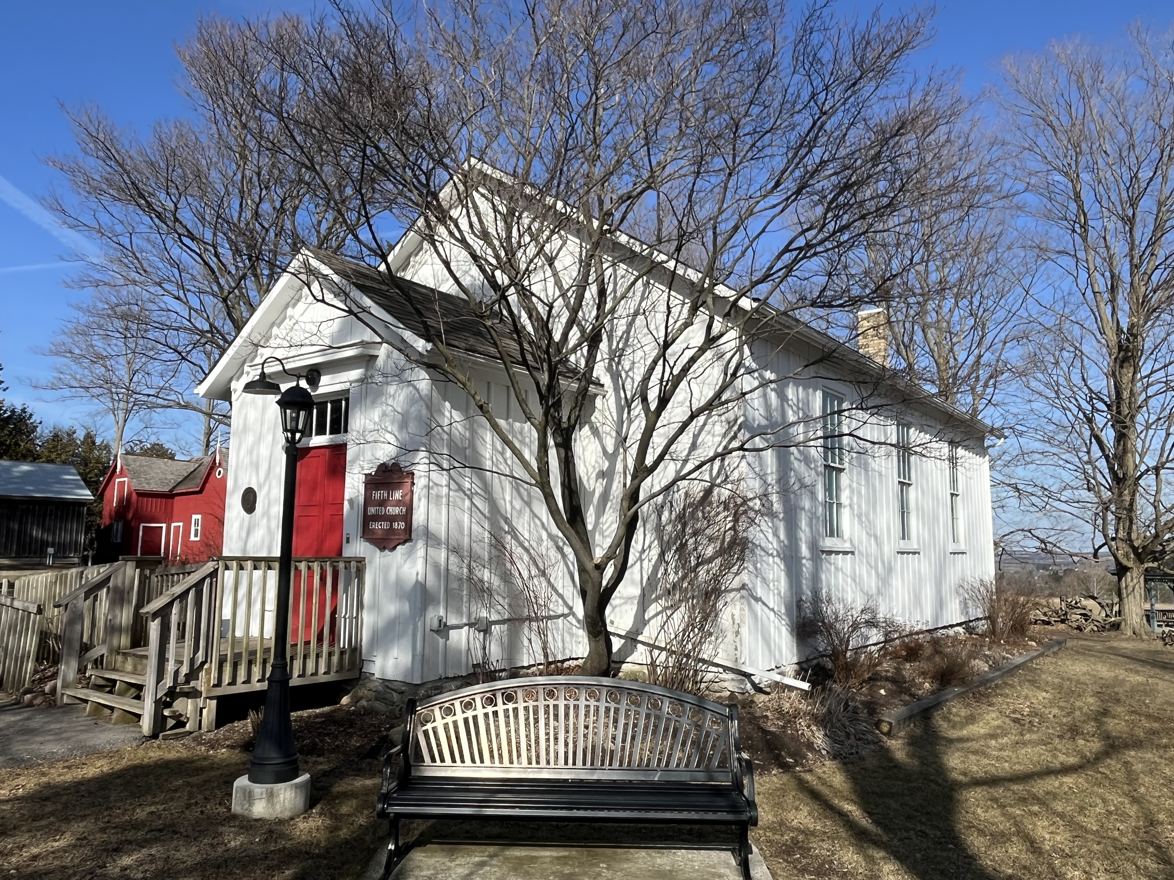
The United Church on site was moved from the west end of lot 16, where it stood closer to Goodwood. It was built in 1870 and dedicated on December 14th. Originally it was a Methodist Episcopal Church and was part of the Uxbridge circuit. It was known either as Forsythe’s or Russell’s Church. In the 1880s the Methodist churches recognized that they had several different types of congregations that basically held the same beliefs with minor variations. They were investing resources to compete with each other for congregants and missions funding and decided that it made sense to unify. The Primitive Methodists and the Episcopal Methodists joined together with the Wesleyan Methodists to become the Methodist Church in 1884. This building then went under the Goodwood circuit. In 1925 the Methodist, Congregationalists and some of the Presbyterian Churches joined together to create the United Church of Canada. After that, the church was known as Fifth Line United Church until it closed in 1966. It was moved to its present location in 1979.

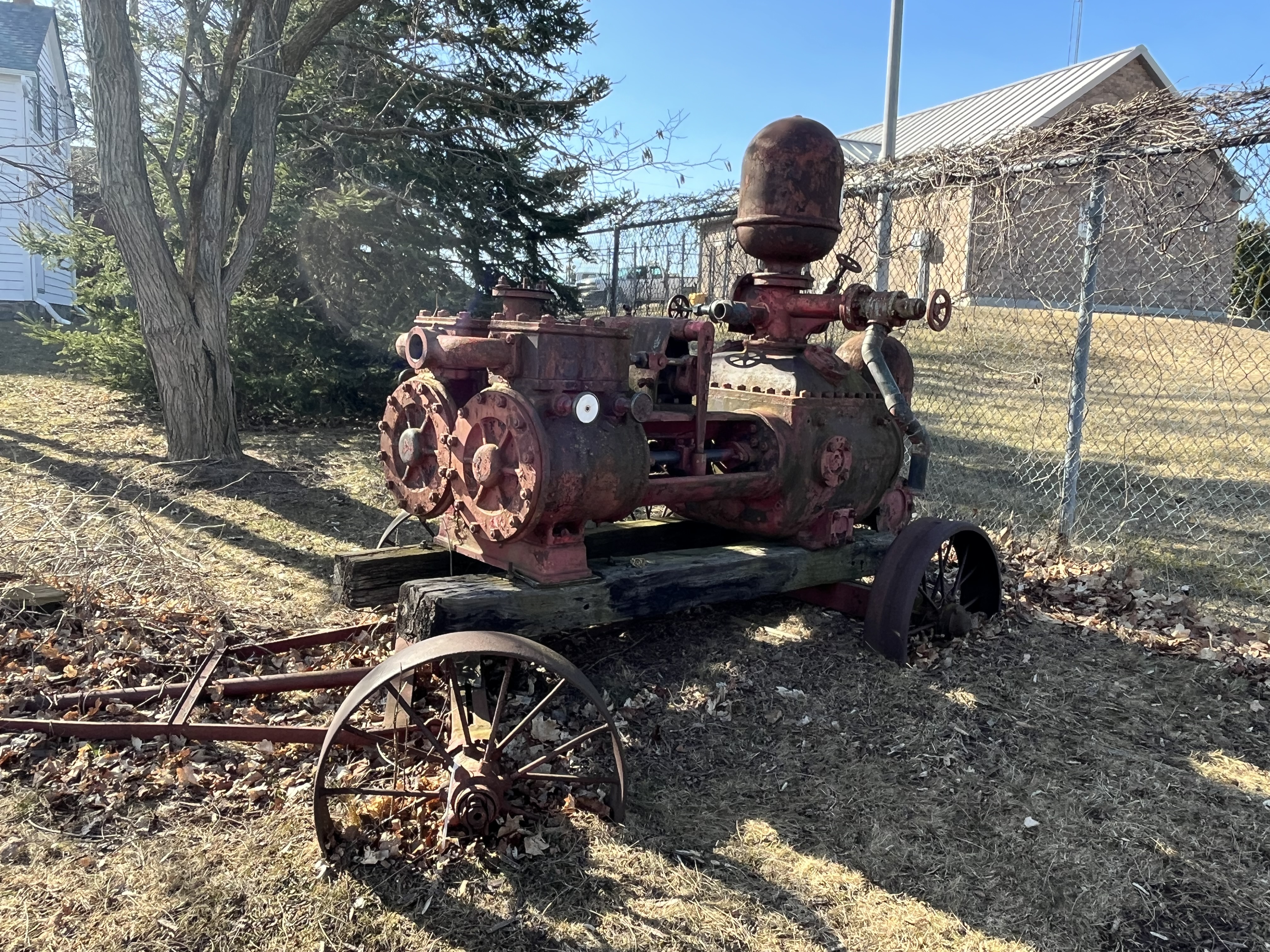
There are many historical pieces of farming equipment that are located on the property and in the various barns and sheds.

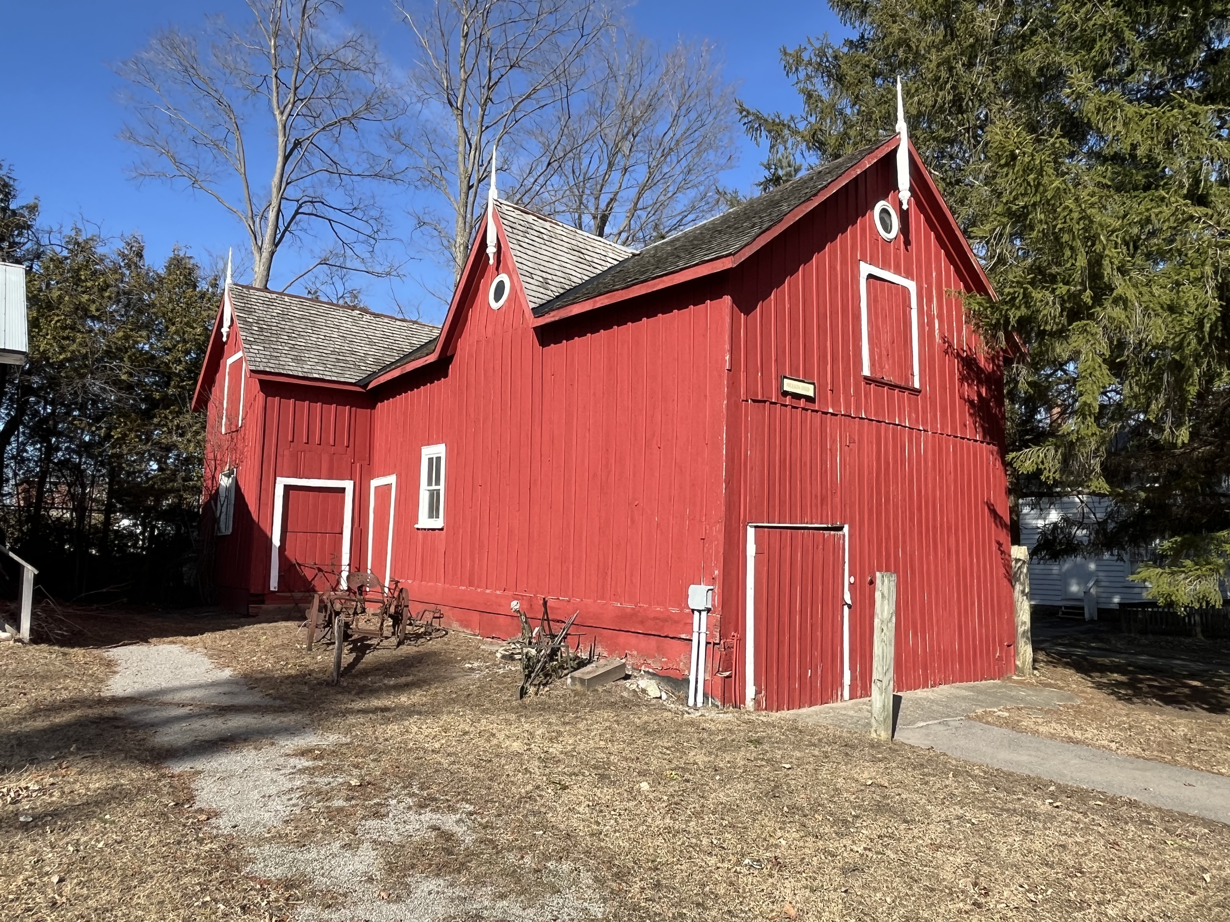
The Hilson Shed was built in the 1800s in Uxbridge and was used as a coach house or carriage shed. It was home to the Hilson family horses, carriage and tackle until they were replaced with a family car. It has been part of the Uxbridge Heritage Centre since 1973.

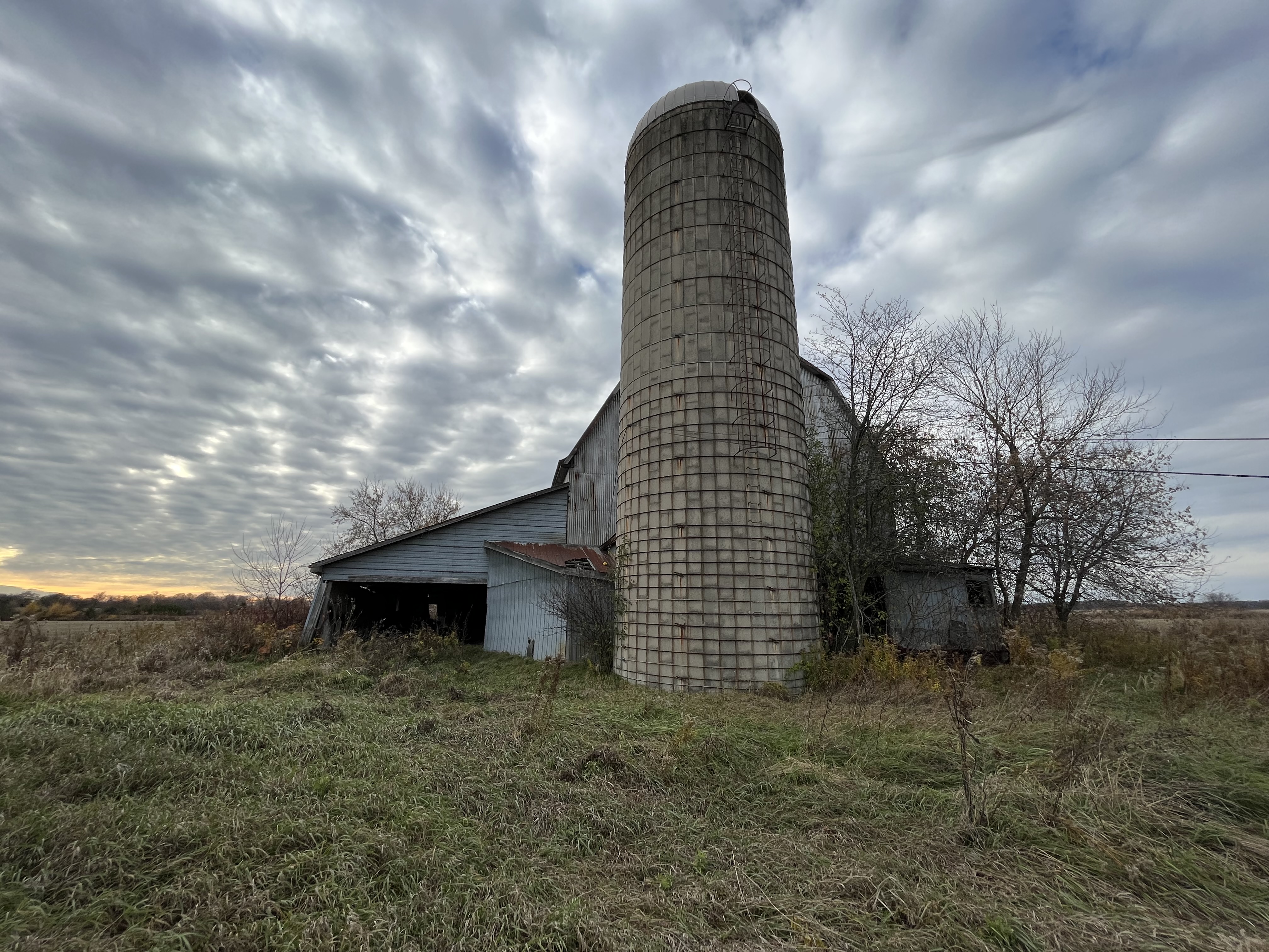
The Nesbitt family drive shed was located on their farm and used by several generations of the family. It has the distinction of having been on the farm that was used for filming seven seasons of Road To Avonlea. This show was based on books that were written by Lucy Maude Montgomery who also wrote Anne of Green Gables. It was disassembled in 1981 and reassembled on the grounds of the Heritage Centre. A sawmill that was located on the same farm was moved to Black Creek Pioneer Village.

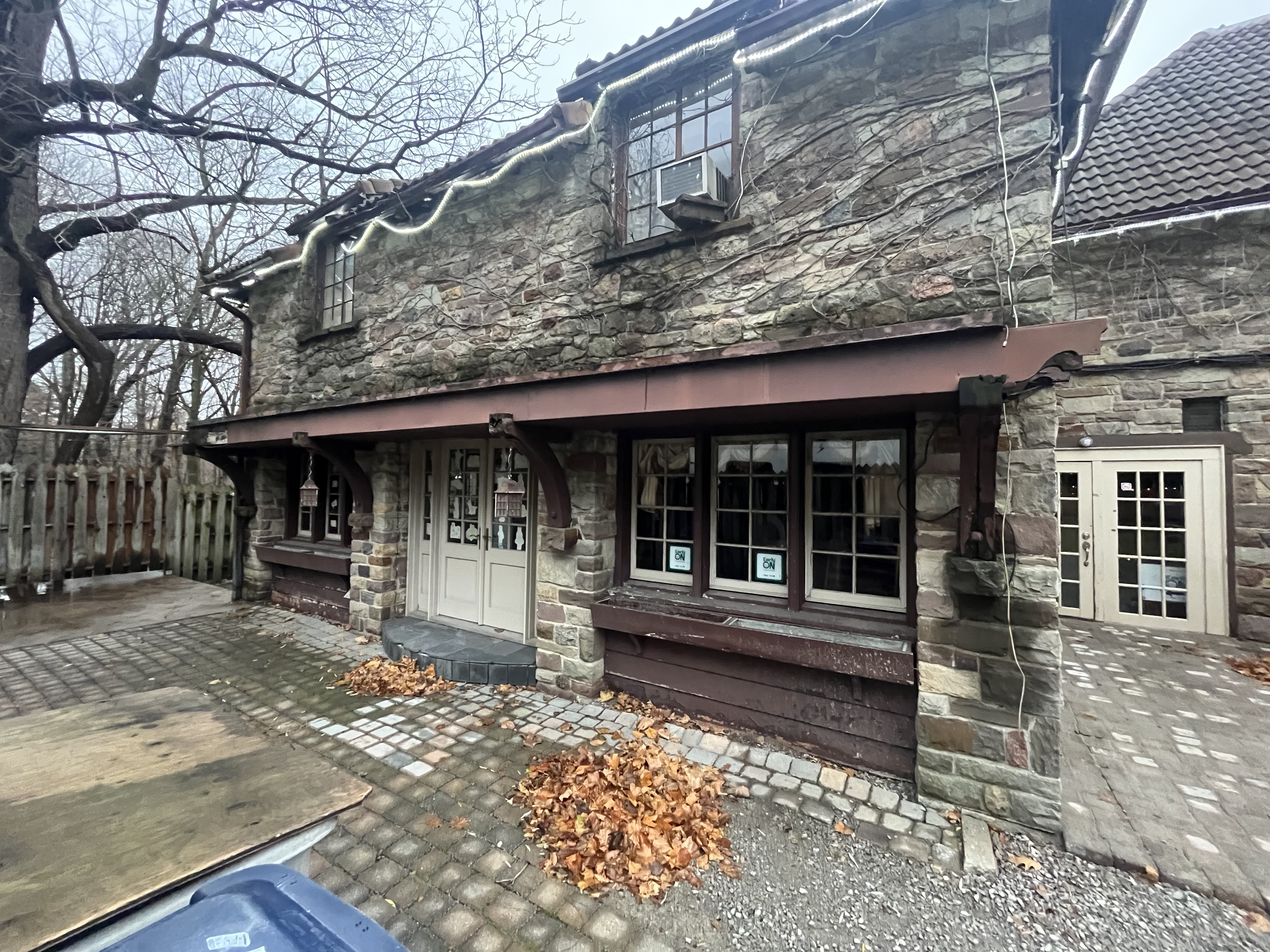
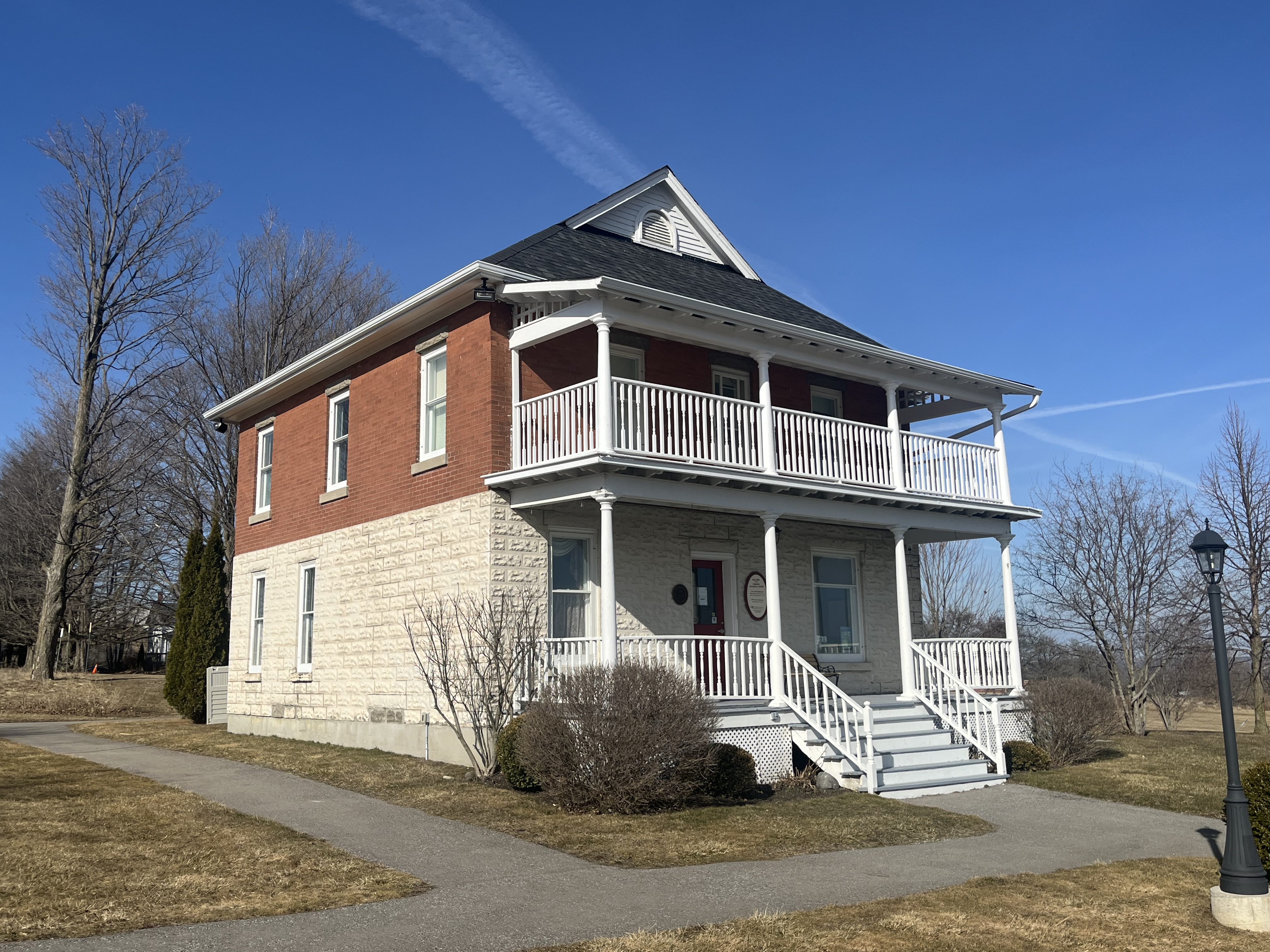
This Edwardian styled house was built in town in 1908 for George Stokes. George was a councilor, deputy reeve and later reeve. The house was later sold to George and Nellie Kydd. In 1963 Nellie became the first female mayor in Uxbridge. The house has a unique two story porch along the front and was moved to the Centre in 2002. It now houses the offices and gallery shop.

The Uxbridge Post Office Bell was donated to the town on its centennial anniversary by Bell Canada on Aug. 26, 1972. It was forged by Jim Taylor in England in 1912.

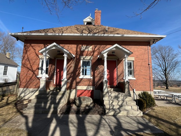
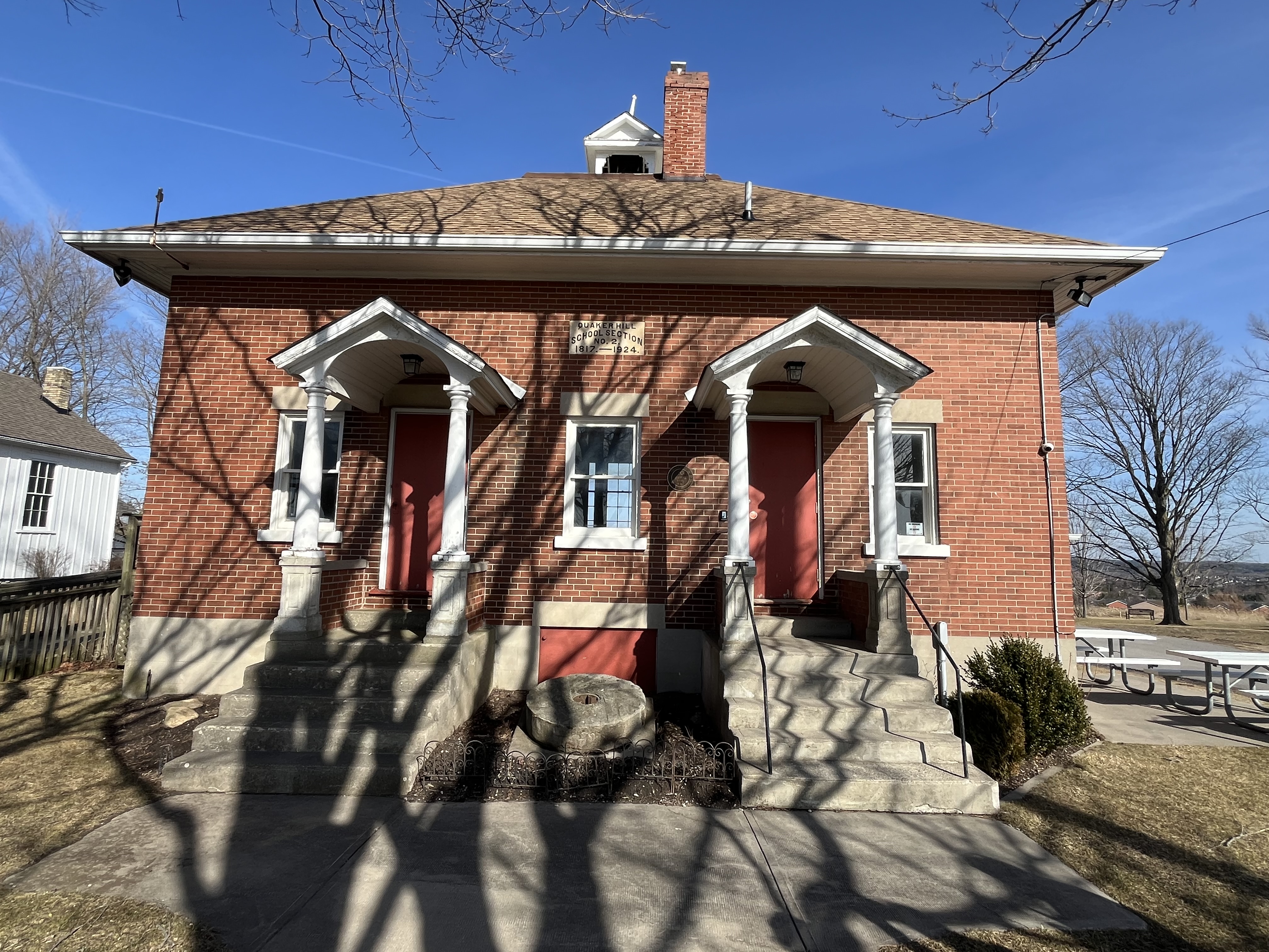
The school is the nucleus for the historical centre and is the third one to be built in Quaker Hill. The first school was built in 1817 by Quaker Ezekial James and was made out of logs. It was the first school in Uxbridge Township. It was located just a short distance south of the present school. It was replaced in the 1850s with a frame building that stood where the present driveway for the school is. The brick school was built in 1924 and served the community until 1969. The two doors were used to allow the boys and girls to have separate entrances so that the boys wouldn’t see the girls ankles when they were changing their shoes as this was considered improper.

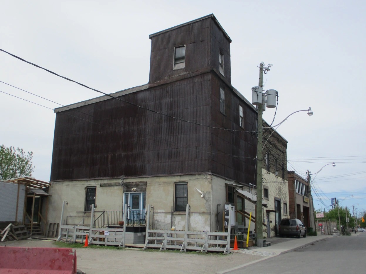
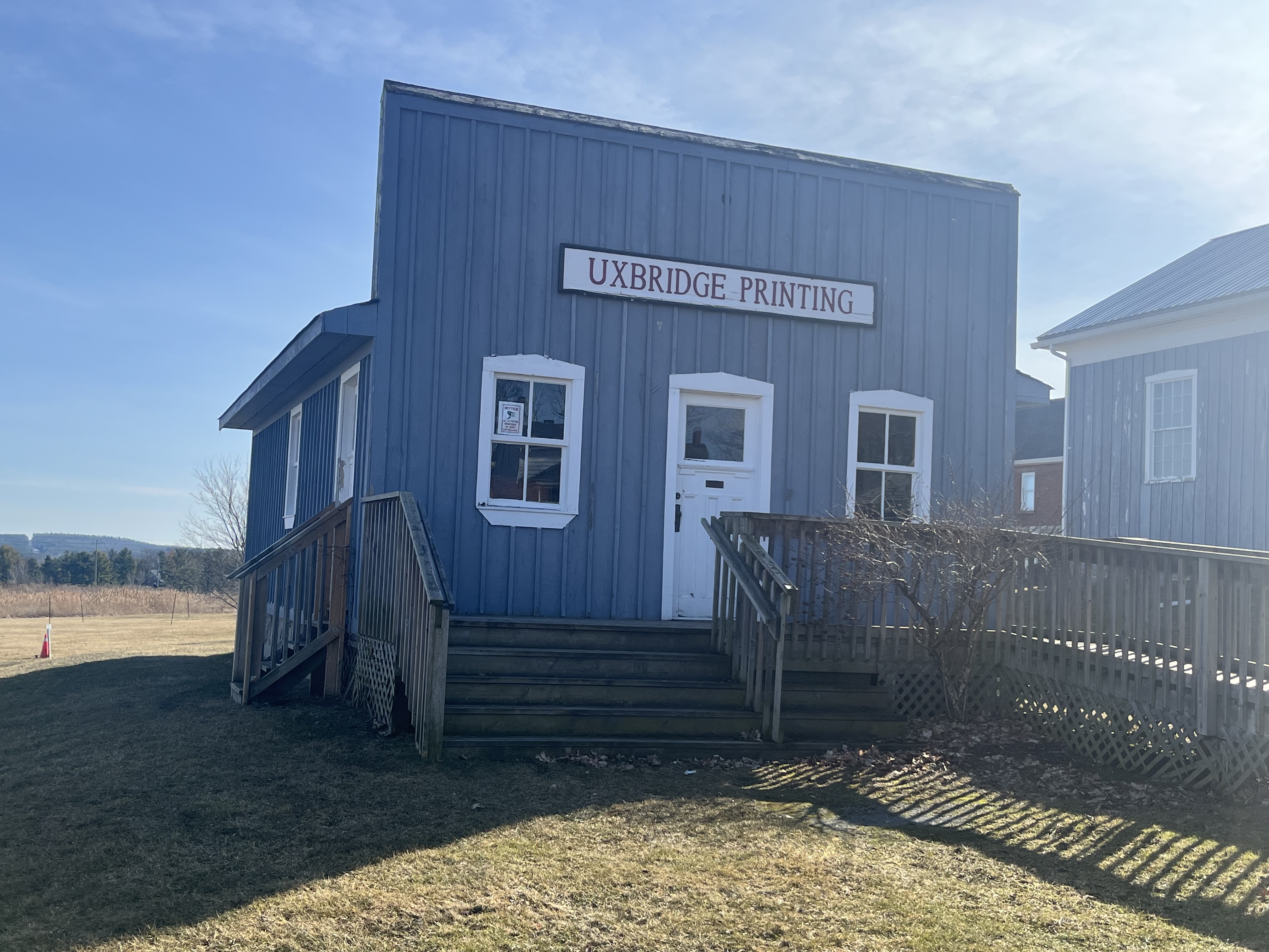
The print shop is not an historical building as it was built on site in 1994. It was erected to house the historical printing equipment from the Uxbridge Printing Company. The large square front is known as the Boomtown Style and was used to make small buildings look bigger. It also hid the front gable and allowed the merchant to have more space to advertise their business.

The buildings are open for tours in the summer months and some of them, like the school, can be rented for functions.

Related stories: Cober Dunkard Church, Black Creek Pioneer Village, Markham Museum, Georgina Pioneer Village, Thomson Memorial Park

Google Maps Link: Uxbridge Heritage Centre

Like us at http://www.facebook.com/hikingthegta

Follow us at http://www.hikingthegta.com

Also, look for us on Instagram.

Oro African Methodist Episcopal Church

Feb.3, 2024

The Oro African Methodist Episcopal Church is a National Historic Site that was designated in 2000. It is the last remaining building in an African Canadian community that was developed in Oro Township between 1830 and 1850. The idea of such a community was first proposed in 1783 by Sir Guy Carlton who was the Commander-in-Chief of British forces in North America. It was thought that integrating African Canadians into a farming community would allow them to settle into a new life in British North America. Carlton had promised freedom to slaves of the American Revolutionaries who fought on the side of the British during the American War of Independence. Many of these people also fought during the War of 1812 under Captain Runchey’s Company of Coloured Men. The 1877 County Atlas image below shows the location of the church as well as a property owned by one of the members. In an apparent act of racism, only the white settlers names are recorded on the map and so I have marked the property of George A Darkman on it as he is featured in this story as an example of the individuals that made up the church. By the time of this map, it was no longer property of the family.

Between 1819 and 1826 twenty-five black men were granted 100 acre plots of land in Oro Township by the British. Eleven of these got their grants in acknowledgement of miliary services. Of these 25 only nine of them would take up their grants and these were along a section of land on Line 1 known as Wilberforce Road. This road was named after the British Abolitionist William Wilberforce who was a politician who fought in British Parliament for the abolishment of slavery in the British Empire. Between 1829 and 1831 another 30 families moved into the community.

A one-acre parcel of land was acquired for use as a burial grounds and to build a church for the community. The church was built in 1849 out of hewn logs which were covered on the outside with clapboard about 10 years later to help keep out the wind and cold weather. By 1900 the community had declined as many of the settlers took advantage of Lincoln’s Emancipation Proclamation. This allowed former slaves to return to the USA and many of the settlers went in search of long lost family members. The British Methodist Episcopal Church declared the building abandoned in 1916 although services were continued until the 1920s.

The building fell into a state of disrepair and by 1947 it was in such poor condition that the local descendants of the original settlers feared that this piece of history would be lost. Efforts were made to restore it with further repairs being made in 1956 and again after vandalism in 1981 when two stolen dump trucks were smashed into the building leaving it seriously damaged.

One of the members of this church was simply known as George. He was born into slavery in Virginia sometime around 1769 and came to Canada prior to 1812. He was one of the soldiers who served in Captain Runchey’s Company of Coloured Men. White settlers were granted 200 acres but black ones were only given 100 acres. George petitioned for a land grant based on his service in the War of 1812 and was granted Lot 15 on concession 2 in Oro Township. In order to receive the land patent it was required that he have a full name and so displaying a sense of humour, he chose George A. Darkman. George left his property to his wife and two children who still lived in the USA and his will is recorded as being the first will to be probated in Oro Township. The will stated that his family had to come to the property within five years and sadly they never made it. Perhaps they were still enslaved themselves. The provision was made that if they didn’t come it would go to a white friend of George, and this is what transpired.

The church was declared a National Historic Site in 2000 but was still left to slowly deteriorate yet again. A cultural heritage assessment was conducted in 2013 and a preservation plan was put into place in 2015. The floor needed to be stabilized and the ceiling joists were reinforced. New cedar shingles were put on the roof and some of the clapboard was replaced. One of the most interesting discoveries during this restoration project was the fingerprint of one of the original settlers which was preserved in the plaster chinking between the logs.

An unmarked graveyard lies in the south part of the property and a cairn was added in 1947 to identify the names of 24 families buried there. 

This church is perhaps the oldest surviving log church from a black congregation in North America and it is fortunate that it has been preserved to help maintain the memory of this important chapter in our shared history. For further reading on early black settlers, see our feature on Griffin House. Also, enjoy our story about Turner Chapel, another African Methodist Episcopal Church. 

Related Stories: Griffin House, Turner Chapel

Google Maps link: Oro African Methodist Episcopal Church

Like us at http://www.facebook.com/hikingthegta

Follow us at http://www.hikingthegta.com

Also, look for us on Instagram

Cornwall Jail

January 13, 2024

The old jail in Cornwall is one of the oldest surviving public buildings in the province. I had the opportunity to visit it on the same business trip that resulted in our past two stories Prescott Waterfront and Lost Villages of the St Lawrence River. This completes a trilogy of Eastern Ontario posts. 

Indigenous People had lived along the St. Lawrence River for thousands of years before the arrival of Europeans. The first formally documented settlement of Europeans in the area occurred in 1784 when United Empire Loyalist moved north from Johnstown, New York following the end of the American Revolution. They founded New Johnstown which was later renamed Cornwall. The Eastern District known as Lunenburgh was established in 1788 and six years later an Act of the Legislature of Upper Canada authorized the erection of a court-house and gaol at Cornwall. That legislature was located in Newark (Niagara-On-The-Lake) beginning in 1792. A two-storey frame structure was built in 1802 and served until 1826 when it was destroyed by a fire.

It was replaced in 1833 with the central block of the structure that still stands on the site. The United Counties of Stormont, Dundas and Glengarry were established in 1850 and the building served as the court-house and gaol (jail). The jail opened in 1833 and just two years later the first escape was made. Four prisoners got out and were never found. The jail was expanded in 1869 by adding two new cell blocks. They were nicknamed “Windowless” and “Hell’s Angels Wing”. Clark Brown was incarcerated there for murdering his father and sister in their home in Winchester and he was executed at the jail in 1879. Other executions at the jail were James Slavin in 1892, John Vergryniuk in 1919, Thomas Collison in 1925 and in 1954 Peter Balcombe. Also in 1954 Henry Seguin was to be executed but committed suicide first.

The jail was modernized in 1971 with security cameras, showers, toilets and electronic locks. In 1985 a general population cell block and a female section was added. A final escape was made in 1995 but the convict was caught in less than an hour as he went to visit his dying grandfather. The jail was decommissioned in 2002 and the inmates transferred to Ottawa.

The aerial view below was taken from the information board at the jail and shows the outdoor exercise yards.

Like many jails, the Cornwall jail had its share of deaths over the decades. People died from suicide, illness, torture and violence as well as the five executions by hanging. There are still many unclaimed bodies which are buried beneath the former exercise yard. They were also buried under what is now the parking lot. During the 1985 expansion of the jail, several bodies were dug up including those of Henry Seguin and Peter Balcombe. It is estimated that there is around 100 bodies buried on the site. This has led to many claims of paranormal activity in the old building and many “ghost hunters” have come to seek evidence.

Tours of the jail are conducted during the summer months, usually between May and August. Check their website at www.historicsdgjail.com for more details and see for yourself if you feel any spirits during your visit.

Related Stories: Prescott Waterfront, Lost Villages of the St Lawrence River

Google Maps link: Cornwall Jail

Like us at http://www.facebook.com/hikingthegta

Follow us at http://www.hikingthegta.com

Also, look for us on Instagram

Prescott Waterfront

December 23, 2023

A recent trip to Eastern Ontario gave me the opportunity to visit Prescott to find some lunch and take a break from driving for a hour or so. I used my time to wander along the Heritage River Trail and see some of the local history of the waterfront. Prescott was named after General Robert Prescott who was the Governor of Canada from 1796 to 1799. Col. Edward Jessup had received a large land grant for his loyalty and service during the American Revolutionary War and in 1810 laid out the streets for a new town on the side of the St. Lawrence River. Within a decade the town had grown to about 50 houses and had several businesses including stores and taverns.

Just two years later the War of 1812 broke out and part of the town was reclaimed by the Government to build Fort Wellington. It was commissioned in 1813 to guard the Galop Rapids in the St. Lawrence. Following the war it was abandoned by the British but officially remained the property of the British Board of Ordinance. It was used by the Canadian Militia until 1923 when it was handed over to the Dominion Parks Commission, which was later renamed Parks Canada. It has been a National Historic Site since 1920. This fort will be an interesting place to explore on a future visit to the area.

The population of Prescott had grown to about 1700 by 1834 and it became the site of the Battle of the Windmill during the Rebellion of 1837.

A railway was established from Prescott to Ottawa in 1854 and soon the waterfront was a hub of railway activity. A roundhouse, railway station and ferry terminal were added soon afterwards. The town became the centre of a major ferry link to the United States. The Canadian Pacific Railway continued operations at Prescott until the 1970s when things were shut down. The piers from the railway terminal are still located in the water and can be seen below and in the cover photo,

A building made of red bricks was built in 1900 by the Imperial Starch Company and it served as a lighthouse. Between 1903 and 1985 it was known as The Dominion Lighthouse Company. The building was used for the production of war materials during the Second World War and then occupied by the Coast Guard from 1962 until 1985. After the Coast Guard moved out, the building was demolished in 1986. The large lantern room housed a Fresnel Lens and the room and lens were saved from demolition. A Fresnel Lens is compact compared to a conventional lens and reduces the amount of materials used by having a series of concentric surfaces. The lens had been used to train lighthouse keepers and it was installed on top of a new tower that the Rotary Club built in 1989.

The Great Lakes Waterfront Trail runs along the St. Lawrence River as part of its 3600 kilometer span but the section through Prescott is also known as the Heritage River Trail due to all the history that is located along the route through town.

Prescott has many historic building as well as Fort Wellington and I look forward to checking out more of them during a future work trip to the area.

Google Maps Link: Prescott

Like us at http://www.facebook.com/hikingthegta

Follow us at http://www.hikingthegta.com

Also, look for us on Instagram

Grain Elevators

December 9, 2023

Grain elevators are used to store grain between when it is harvested and when it is sent to the point of use. They have been around in North America since 1842 when they were developed to store grain being transported via the Erie Canal. Some elevators are very large and communal in their function while some are also used for milling or personal applications on farms. In this post we share pictures we have taken of some of them in Ontario and Manitoba.

Elevators were made with a sturdy wooden crib built of 2 by 8 boards that then had 2 by 6 inch ones stacked up to form the walls and internal bins. The outside would be covered with a wooden veneer which was originally painted red if along a CPR line. Wheat can weigh up to 60 pounds per bushel which means that a 25,000 bushel elevator could have 1.5 million pounds (680,000 kgs) of weight in it. This puts a lot of lateral pressure on the walls. Eventually, elevators that would hold 60,000 bushels were constructed. All elevators, regardless of size, had three basic elements. The elevator, the driveway and the office/engine room. A truck or wagon of grain would be driven onto a scale and weighed and the grain sampled to see what quality it was. It would then be dumped through the floor into the pit where it would be taken up the leg and poured into the correct storage bin. The empty truck would then be weighed again and the amount of grain deposited would be calculated from the weight difference. When it was time to load a train the appropriate grain would be pumped into the back hopper and then down a spout into the waiting boxcar. The illustration below was taken from The Canadian Encyclopedia and shows the inner workings of a grain elevator.

The first grain elevator on the Canadian prairies was developed in Niverville, Manitoba in 1879 and was basically a grain silo. The more traditional shape started to appear in 1881 in the form of 25,000 bushel elevators. The CPR began to offer free land along their rail lines to allow the construction of standard size elevators. While on a recent business trip to Manitoba I was able to photograph the two grain elevators that appear next in this article.

The United Grain Growers had built a grain elevator in Elie, Manitoba in 1928 which has since been demolished. A larger grain elevator was built just west of town in 1986 with a capacity of 3,750 tons. In 1998 the Manitoba Pool and Alberta Pool merged creating Agricore. The elevator was then closed in 2002 but has since been bought by some local farmers who continue to use it. Unlike the majority of elevators, this one has no direct rail access.

A little west of Elie is the town of Oakville, Manitoba. When their 1928 Pool B elevator burned down in December 1973 it was replaced with the present wooden structure. This building was completed between 1974 and 1975 and had a capacity of 162,000 bushels. It was expanded in 1990 by adding the three steel tanks on the west end that brought the capacity up to 204,000 bushels. When the merger happened in 1998 its days were numbered. It was closed in January 2001 as a temporary cost cutting measure by Agricore and permanently closed in November 2001. Like the elevator in Elie, it is now operated for private grain storage. It can be found at this map link.

The CPR built a line through Pontypool, Ontario in the 1880s which opened up the Toronto market to local farmers. In 1894 a grain elevator was built and before long there were two elevators serving the community of about 600 residents. Both of these were gone by 1918 and a new one was constructed for the local farmers to store their barley, oats and wheat before shipping it to market. As transportation systems improved the elevator became less important and by the 1970s it was closed. It can be found at this map link.

The Canada Malting Company located a set of concrete silos at the foot of Bathurst Street in 1928.  Storage silos had disappeared from the city because they were made of wood and had a lifespan of about ten years due to the fact that they were severe fire hazards.  The Canada Malting Company used concrete silos to store barley in before it was turned into malt.  The original silos near the lake were 120 feet tall and more storage was added in 1944 in the form of 150-foot tall silos. These grain silos can be found at this map link.

There are two grain elevators in the town of Schomberg, Ontario.  In 1884 Anderson Tegart built the Schomberg Feed Mill on Main Street where it had direct access to the railway.  It operated until 1927 before it shut down.  Since that time it has housed a variety of businesses including The Scruffy Duck Restaurant which is still in business. This elevator can be found at this map link.

An orange grain elevator stands on the side of Highway 9 close to Highway 27 that used to have the Shur-Gain symbol on the side.  Shur-Gain was introduced in 1937 as a brand name by Canada Packers.  They provided feed for animals and livestock.  Today there appears to be renovations going on at the old feed mill. This elevator can be found at the following map link.

I have driven through Consecon in Prince Edward Ontario several times on recent business trips and kept looking at the old grain elevator that stands beside the Millennium Trail on the old Price Edward County Railway. Yesterday I stopped to take pictures of the structure. The Consecon grist mill was built in 1808 and spurred development of the community. After several rebuilds it was purchased by Richard Baldwin in 1949. He built the grain storage building beside the tracks the same year. When rail service ended through town in 1985 the building was abandoned. It can be found at this map link.

Nashville, Ontario grew as a railway town centered on the railway station.  Soon a saw mill and a grain elevator stood near the railway.  Milling grain creates a lot of dust which becomes a fire hazard.  Many grist mills and grain elevators were destroyed by fire and this was the fate of the original grain elevator in Nashville.  The first elevator burned on July 15, 1919 while a second one was destroyed in 1927. A new grain elevator was built in Nashville in 1930 and still stands beside the tracks. We featured it in our post on Abandoned Kirby Road and it can be found at this map link.

A grain elevator still exists within the city of Toronto on Dawes Road. When it comes to research on the internet it is easy to find conflicting information.  Construction dates range to as early as the 1850s with 1890 also being a prominent date.  The city’s land use maps suggest 1906.  The land developers have to present a historic context in their proposals and they also claim it to be a 1906 wooden crib grain elevator and feed mill.  The use of construction materials would suggest that the 1906 date is correct as the first-floor cement would not have come into popular use until after 1900. This elevator can be found at the following map link.

At one time almost every farm in Ontario had a silo beside the barn. Many of the barns have vanished but the concrete silos still dot the rural landscape. These were essentially private grain elevators that were used to store grain for feeding livestock.

Grain elevators come in many different shapes and sizes but they are slowing disappearing from the landscape.

Related stories: Pontypool Grain Elevator, Ireland Park with Bathurst Street Grain Elevator, Schomberg, Chalmer’s Milling Company, Abandoned Kirby Road

Like us at http://www.facebook.com/hikingthegta

Follow us at http://www.hikingthegta.com

Also, look for us on Instagram

Stonedene Estate

December 02, 2023

Starting in the 1920’s the wealthy of Toronto were building mansions in the area of Bayview Avenue and Lawrence Avenue. This was a rural setting at the time which featured the Don River for fishing and large lots with plenty of places to ride their horses. We’ve covered a number of these in past issues of our blog and they can be found in the links at the end of this post.

Today we’re looking at Stonedene which sat on Bayview just south of Post Road. It dates to the end of the 1920’s, reportedly built in 1929. The image below from the Toronto Archives aerial photograph collection shows the property as it was in 1957. Post road runs along the top of the picture and Bayview Avenue along the left hand side. The mansion can be seen near the middle of the image, set at the apex of a curved driveway.

Living up to its name of Stonedene, even the gates are made of stone and the fence that once separated it from the road was supported on several stone pillars. The main entrance has the name Stonedene carved into it and the stone pillars still line Bayview Avenue.

The home was built in 1929 according to city records and was originally constructed for Captain Harry Lynne Plummer and his wife Joyce. Plummer served in the First World War as a member of the 4th Canadian Mounted Rifles and as a Captain in the Canadian Railway Troops.

By 1949 it had been sold to General Albert Bruce Matthews and his wife Victoria. Matthews served in the Second World War as a member of the 1st Canadian Infantry Division. He was promoted several times during the war and as General Officer Commanding the 2nd Canadian Infantry Division he took part in the liberation of northern parts of the Netherlands. After the war he became chairman of Massey Ferguson and was President of the Liberal Party of Canada during the 1950s and 1960s.

The home was sold in 1976 to the Ontario Mission of the Deaf and converted into administration offices. It has a front door that reminds me of the entrance to a castle.

A structure sits on the front lawn that looks like a stone chair or throne.

The back of the chair has a date stone which reads 1925 which is in conflict with the official date of the mansion.

Everything about the home is grand including the side entrance which has an ornate double door with sidelights.

The gardens around the south side of the house have become a little overgrown but add to the character of the mansion.

Ontario Premier William Davis laid the date stone for the Bob Rumball Community Centre for the Deaf on April 5, 1979. This multi purpose building is used to provide services for all ages of the hearing impaired. There are youth services as well as seniors programs and sign language courses. It was conceived by Bob Rumball who played football for the Toronto Argonauts and Ottawa Roughriders. He got financial support from Conn Smythe and Harold Ballard of the Toronto Maple Leafs.

The historic photograph at the top shows all the freshly planted trees on the front lawn which today provide a forest that hides the house from the road. The mansion was given a restoration in 1996 when the administration offices were moved upstairs. The lower floor is now an event centre and can be booked for weddings.

Stonedene is a great example of the wealthy estates that were built in the area in the late 1920s by Toronto’s millionaires. Many of these still exist and can be viewed in the links below.

Related stories: Windfields Estate, Frank P Wood Estate, York Lodge, Bayview Estates

Google Maps Link: Stonedene

Like us at http://www.facebook.com/hikingthegta

Follow us at http://www.hikingthegta.com

Also, look for us on Instagram

Buttonville Airport

October 21, 2023

It’s the end of an era for Buttonville Airport as the facility will be closing on November 30, 2023 after 70 years. It began in 1953 as a grass airstrip and eventually became an official airport in 1962. The airport was built on farmland well north of the city on property that used to belong to John Button, the founder of Buttonville. The image below shows the airport in 1960 with the community of Buttonville to the south east. Highway 404 wouldn’t be built until the 1970s and presently runs along the west side of the airport. The first construction of the Highway began in 1975 with it opening from Highway 401 to Steeles Avenue in 1977. The part running past the airport was completed in 1978. 16th Avenue is seen running along the top side of the airport. At this time it was a dirt road but now it is a major thoroughfare.

The airport was purchased by Michael Sifton in 1963 to add to their land holdings in the surrounding area. At that time, there was a metal hanger and a grass landing strip. The Sifton Family opened a new company called Toronto Airways Ltd and started to make improvements to the property. They built a terminal and in 1967 they added an air traffic control tower on the north end of the property near 16th Avenue.

Over the years several more buildings have been added to the airport to support the tenants. Aside from charter companies, the airport also is home to Toronto Police Services and they fly their helicopter out of here. Seneca College has a flight training school as does Toronto Airways. York Regional Police and Canadian Traffic Network also call the airport home and make their flights from here.

There are between 160,000 and 170,000 aircraft movements each year out of the facility.

In 2006 Nav Canada built a new air traffic control tower on the south end of the property to replace the aging facility on the opposite end of the runways. They built it in a modular format so that it could be taken apart and moved elsewhere at some time in the future.

The Buttonville Flying club owns 70 aircraft out of the 300 that are stationed at the airport. Some claim that before Tom Cruise starred in Top Gun he took flying lessons here. Michael Sifton died in 1995 and since then there have been rumours that the airport will close. In 2009 the Greater Toronto Airport Authority cancelled a $1.5 million per year subsidy and the fate of the airport was effectively sealed. In October 2010 Armadale and Cadillac Fairview announced a residential and commercial redevelopment for the site.

The closure date for the airport has been set for November 30, 2023 after which the current tenants will have to be relocated to other airports around the area. One source estimated that of the current airplane movements at the airport up to 70,000 wouldn’t be accommodated at other local airports. The most recent plan for the airport has the lands being used for industrial purposes. Eleven one story industrial buildings are planned to be built over the coming years. The image below was taken from Urban Toronto and shows the redevelopment proposal.

It is unclear where the current tenants will relocate and many of them may cease operations because other local airports can’t absorb all the airplane movements that will be lost.

Google Maps Link: Buttonville Airport

Like us at http://www.facebook.com/hikingthegta

Follow us at http://www.hikingthegta.com

Also, look for us on Instagram

Prehistoric World

September 30, 2023

Prehistoric World is four hours east of Toronto so it’s not the kind of place you visit on a day trip. However, I get to travel around Ontario for work and it allows me the opportunity to visit some places between appointments. I had some time off when staying in Morrisburg and so I decided to make a visit to this secret prehistoric world which is a well kept secret on its own. There is no formal advertising and the website was taken down in 2015. A sign on the side of Highway 2 about 9 kilometers east of Morrisburg is the only indication of its existence.

Prehistoric World came from the imaginations of two brothers who wanted to have a place to display their art. Together, Paul and Serge Dupuis decided to turn an 150 acre property into the back yard of their childhood dreams. So far they have transformed 28 acres with over 50 life size recreations of dinosaurs and other prehistoric animals. When they opened in 1981 they had many less statues than they had hoped to have but they have been constantly adding to their display as the years go by.

One of the earliest animals to be included in the park is Protosuchus. It lived about 200 million years ago and is said to be an ancestor of modern crocodiles. It was likely a good swimmer and a good runner and has sharp teeth that indicate that it was a meat eater.

New statues are worked on over the winter with the steel understructure being welded up in their workshop. In the spring they move the frame to its location along the trail and then cover it with concrete. Once the concrete has set, it is painted and a bilingual sign is installed to describe the animal that is being depicted.

Dimetrodon lived about 300 million years ago and was the largest carnivore of its time. It has a large dorsal fan which was used to regulate its body temperature. It could absorb heat and also be used to radiate excessive heat.

The displays start just outside the back door with the earliest lifeforms. As you make your way along the path the animals generally become larger as you follow the timeline. There is even a Fossil Pit for the budding archaeologist to play in. Hidden under the sand are 21 “fossils” that can be discovered. The only rule is that you can’t use any tools because the castings under the sand could get damaged. So, you are left to uncover them with just your hands. A few small pieces can be seen sticking up through the sand here and there.

The Ice Storm in January 1998 caused considerable damage and several sculptures were completely destroyed when trees fell on them. Paul estimates that they could likely have had about 70 statues by now if they hadn’t lost so many which were never replaced. The time spent on scaffolding doing repairs to the remaining statues prevented them from installing any new displays for quite some time.

Shunosaurus was one of the earliest sauropods and had a relatively short neck compared to later animals in this family. It was discovered in China and is the only member of this family to have a bone club on the end of its tail for defensive purposes.

There are several new sculptures in various stages of completion in the workshop and so new ones will continue to be added in the future. All of the work has been completed by Paul and Serge with no outside help. There is a long-term desire to have the park turned over to an artist collective that would carry on the work when the two brothers are no longer able to do so themselves.

The path through the site is about one kilometer long and is made of poured concrete. This has been carefully scored by hand with a trowel to create the impression of cut stones laid into a pattern. The pathway leads from the back of the house, through the yard and into the woods where it makes a loop and comes back.

Nodosaurus was named for all the small nodes that cover the plates that protect its back. It was discovered in Wyoming and Kansas.

Protoceratops was one of the first “horned” dinosaurs and lived about 80 million years ago. It had a large neck shield but no actual horns and is the most famous dinosaur from the Mongolia area. It was often found with nests of eggs including partially hatched specimens.

Ouranosaurus was first discovered in 1965 in Niger, West Africa. It lived about 110 million years ago and was distinctive for the large sail on its back. This set of extended spines was covered with skin and many blood vessels that allowed the animal to exchange heat and control its body temperature.

Stegosaurus lived in North America about 150 million years ago and is one of the dinosaurs that I was most impressed with as a child because of its body armor. The double row of plates on the back were used for temperature control while the spikes on the tail were a defensive weapon. This animal had a very small brain which was about the size of a walnut.

Triceratops had three horns on its face and a large bony shield to cover its neck. It lived in North America about 70 million years ago. It was the largest of the ceratopian, or horned, dinosaurs and if challenged it would likely have lowered its head and charged into the belly of its opponent. The horns would have provided a major defensive weapon.

Tyrannosaurus Rex was the largest of the carnivorous dinosaurs and could reach 8 tons in weight. It lived 65 million years ago and although Hollywood loves to show it as a top predator, it may have been more of a scavenger because smaller animals could have likely outrun it.

Brontosaurus is the biggest statue in the park, being one of the largest land animals to ever walk the Earth. From the nose to the tip of the tail it could be over 70 feet in length. Since the workshop isn’t big enough to accommodate the steel structure for this animal it was created in 14 pieces and assembled on site.

Wooly Mammoth stood 14 feet tall at the shoulder and are ancestors of the Elephant. They get their name from the thick coat of hair that covered their hides and they lived between 1 million years ago and about 10,000 years ago. Examples of this pachyderm have been found all over the Northern Hemisphere as well as entire animals being found frozen in the permafrost of Siberia and Alaska.

The largest mammal ever discovered was Baluchitherium which stood 18 feet tall at the shoulders. It weighed almost thirty tons and lived about 20 million years ago. It is said to have been an ancestor to the Rhinoceros. This statue is tall enough that the path leads right under its belly.

Prehistoric World will take a little over an hour to walk through if you stop to read each of the information plaques. The entry fee is only $10.00 for adults and $6.00 for children making it one of the affordable places to visit.

Related Stories: Scarborough’s Steel Dinosaurs, The Royal Ontario Museum – Dinosaurs

Google Maps Link: Prehistoric World

Like us at http://www.facebook.com/hikingthegta

Follow us at http://www.hikingthegta.com

Also, look for us on Instagram

Sudbury Regional Hospital

August 26, 2023

St. Joseph’s Health Centre in Sudbury has gone through many changes and will likely be demolished soon. The history goes back to 1944 when the sisters of St. Joseph at Sault St. Marie took on the project of building a new hospital in Sudbury. A group of doctors had contacted them and requested help in creating a facility in Sudbury. The government was not into financing hospitals at that time so the sisters mortgaged their homes to finance the construction. They started by purchasing a seven acre site on Paris Street. It took until 1950 to complete at a cost of $3.1 million dollars. The image below shows the entrance to the former hospital.

When it opened it had 200 beds but within 4 years another treatment wing was opened that added an additional 100 beds to the hospital. By 1960 there were 326 beds in the building which had originally been planned to serve 190 beds.

Eventually there were three hospitals in the Greater Sudbury Area and the General Hospital, as it came to be known, began to specialize in trauma care and surgeries. By 1980 a CAT scanner was added to go along with the Nuclear Medicine, Intensive Care, Neurosurgery and poison control departments. At this time the hospital had 375 beds.

The hospital took on a greater role in trauma care in the region and consequently, on October 16, 1986 the new helicopter pad was opened. This allowed the hospital to receive air transported patients from great distances. All three Sudbury hospitals were amalgamated in 1997 under a provincial restructuring plan. Construction soon began on Health Sciences North and St. Joseph’s was closed on March 29, 2010.

A study was completed to see if the building could be repurposed as a long term care facility but it wasn’t fiscally practical. Developers bought the site with the initial idea of making an apartment out of the old structure. Eventually this idea was abandoned and the building continued to sit untouched until 2019. That summer muralist RISK was commissioned to paint a mural on the outside of the structure as part of the annual urban art and music festival known as the Up Here Festival. The festival aims to beautify the city by installing murals and other public art as well as providing a music festival. When it was completed the 80,000 square foot mural became the largest mural in Canada.

The hospital was built backing into some rocky landforms and because it was out of sight of the road, the back side wasn’t painted with the mural. The image below shows how many of the windows have been broken by vandals.

On August 8, 2023 the developers put forward a new plan that includes the demolition of the existing hospital structure and the construction of three buildings. A 20 story condominium, a 16 story rental tower and a 12 story retirement residence. I am in Sudbury for work four times a year and will keep an eye on what happens to the site.

Google Maps Link: Sudbury Regional Hospital

Like us at http://www.facebook.com/hikingthegta

Follow us at http://www.hikingthegta.com

Also, look for us on Instagram

Hambly House – Nobleton

August 19, 2023

Nobleton was founded in 1812 and existed as a crossroads community for several decades before expanding with a series of side streets. Taverns and hotels were built as well as a couple of general stores and a post office. Joseph Nobel was a tavern owner and it is his name that was given to the community. The former blacksmith shop from Nobleton has been moved to Black Creek Pioneer Village. The image below is taken from the 1877 County Atlas and shows the modest size of the community at that time. The green arrow points to the location of the Hambly House.

At the north west corner of the intersection of modern King Road And Highway 27 stands the Hambly House. A log cabin had stood on this corner until it was destroyed by a fire. William Hambly had come from the United States as a United Empire Loyalist. His son, Charles operated one of the two general stores in Nobleton and was also the Post Master. Starting in 1851 the mail used to come to Nobleton three times a week via the Gore and Vaughan Plank Road. Hambly had two sons, Elwood and George who both worked in their fathers store. When Charles replaced the log cabin in 1885 he did it in the grand style of the Victorian architecture of the era.

Bargeboards, or gingerbread, adorn the various gables found around the house and the red brick is accented with buff coloured ones through most of the home. Yellow brick forms the quoins found on the corners and also double banding along the second floor which is adorned with a series of the letter “X”.

The house features a three story tower with a mansard roof, typical of the Italianate style of construction. The tower has iron cresting and a weather vane on top.

The south elevation and the north both feature two story bay windows which are adorned with segmental arches above and rectangles below. Pointed wooden finials rise from the tips of the gables.

The west elevation of the house does not have complete banding on the one section. There is a chimney on the back which was a later addition and is made of a darker colour of bricks.

The Hambly House is currently empty and the adjacent property is under a development proposal. While the house is protected under the heritage registry number of 82-144 it is planned to be turned into office space as part of the proposal. As usual, it remains to be seen what the final outcome of the Hambly House will be.

Related stories: Gore And Vaughan Plank Road

Google Maps link: Hambly House

Like us at http://www.facebook.com/hikingthegta

Follow us at http://www.hikingthegta.com

Also, look for us on Instagram