Tag Archives: Gooderham & Worts

Gooderham Architecture

Sunday, July 18, 2020

Three generations of the Gooderham Family made their mark on Toronto through the distillery of Gooderham and Worts.  Their factory is remarkably well preserved in The Distillery District but they also left their mansions and some major projects, including the King Edward Hotel built in 1903.

The oldest surviving architecture that can be attributed to the Gooderham Family is the church at 245 King Street East.  Situated just a little north of the Gooderham and Worts distillery the church was founded because many of the factory workers and others in the community couldn’t afford to pay pew fees to attend Bishop Strachan’s Anglican Church.  With the assistance of these two families the Little Trinity Church was built in 1843.

IMG_4359

The four buttresses that form the corners of the bell tower are repeated at the rear of the original church.

IMG_4362 (1)

Beside the church stands the rectory that was home to the priests who served the congregation over the years.  The rectory was built in 1853 and is an example of Romanesque and Gothic Revival architecture combined.

IMG_4369

Charles H Gooderham was the eighth, and youngest son of William Gooderham and in 1882 he had a home built at 592 Sherbourne Street.

IMG_4355

George Horace Gooderham built the house at 504 Jarvis Street in 1891 in the Romanesque Revival style that was popular with the family architect David Roberts.  Roberts and his son would design the majority of the buildings at Gooderham and Worts Distilery. George H. was the grandson of the company founder and added his home to a growing list of The Mansions of Jarvis Street.

IMG_4075

The Gooderham Building is one of the best known structures from the early days of Toronto.  It is also known as the Flatiron Building after the more famous one in New York City.  Interestingly, the Gooderham Building predates the NYC one by a decade.  It was built to house the offices of Gooderham and Worts when the business was booming and had outgrown the offices at the distillery.

IMG_4372

George Gooderham took the office in the top of the five story building where he had a commanding view east along Front Street toward the distillery and the Don River.

IMG_4378 (1)

The Gooderham Building was completed in 1892 and was adorned with plenty of carved stone.  It was built for $18,000 and served as the offices Gooderham and Worts until 1952.  It has been protected by a heritage easement since 1977.  Heritage easements are agreements that are placed onto the title for a property and set out details of building which must be maintained in perpetuity.  They may also spell out conditions for renovations.

IMG_4386 (1)

The Flatiron Building has one central window on each floor on the back end of the building.  In 1980 a Canadian artist named Derek Besant won a competition to create a public mural for the building.  He chose to paint a reflection of the Perkins Block across the street which gives the building the appearance of having more windows that it actually does.

IMG_4390 (1)

The Perkins Block was designed as a warehouse extension and storefront for a wholesale grocer named Frederick Perkins.  It was completed in 1875 and faced the original three story building named The Coffin Block that stood where the Gooderham Building would be constructed.  Notice the Italianate brickwork with multiple arches on the fourth floor windows.  These can be seen on the Flatiron Building mural.

IMG_4389 (2)

Between 1890 and 1892 George Gooderham built an imposing mansion on the corner of Bloor Street and St. George Street.  He had inherited the distillery when his father passed away in 1881 and was involved in the world of finance.  He founded the Bank of Toronto which is now the TD Bank.

IMG_4401

The house features a domed witch-hat tower, similar to the one on the Gooderham building.  Fancy brickwork on the chimney is complimented by the carvings around the tower base.  When George passed away in 1905 his widow Harriet sold the house and it has been home to The York Club since 1910.

IMG_4408

By the turn of the century the affluent neighbourhood had moved north of Bloor Street and the area of Rosedale became home to the new rich families in the city.  Edward D. Gooderham was one of the sons of William George Gooderham and he built his home in 1907 on Sherbourne Street North among the mansions of Rosedale.

IMG_4418

Built in 1908 the home at 112 Waren Road in Forest Hill represented a presence for the  Gooderham Family in the next wealthy neighbourhood.  The house features seven bedrooms in its two and a half storys.

IMG_4415

Albert Edward Gooderham was a grandson of the founder and had joined Gooderham and Worts as a clerk in 1879 at the age of 18.  When his father passed away in 1905 he became the Managing Director. In 1915 he bought 85 acres at Dufferin and Steeles.  Here he built and equipped Connaught Labs to produce tetanus antitoxin.  The labs later became the production facility for Toronto Insulin which benefited countless diabetics.  The buildings below are part of the Gooderham architectural legacy.

img_2793

Both the buildings that George Gooderham completed in the early 1890’s are adorned with conical towers but also fantastic details that present little surprises as you study them.  The red stone from The Credit Valley has been intricately carved such as this example above a window opening on George’s home.  A pair of lion heads and the head of a man who looks a little surprised to see them there.

IMG_4412

The Gooderham Family has made a lasting impact on the architecture of the city with another forty-five buildings in The Distillery District that bear exploration.

Like us at http://www.facebook.com/hikingthegta

Follow us at http://www.hikingthegta.com

Also look for us on Instagram

The Distillery District.

Sunday, July 12, 2020

The story of the Distillery District starts in 1832 with the idea for a grist mill on the east end of York (Toronto) harbour.  James Worts had been a miller in Suffolk, England before moving to York.  He built a 70-foot tall windmill that was a prominent feature on the York skyline and started a milling business with his brother-in-law William Gooderham.  Together they started a business that led to the largest distilling operation in Canada.  However, disaster struck in 1834 when James Worts lost his wife in childbirth.  Distraught, he jumped in the well at the mill and drowned himself just two weeks later.  Gooderham adopted his children and raised them along with his own thirteen.  Among the adopted was James Gooderham Worts who would become his partner in the business.

Their position on the waterfront provided easy access to large quantities of grain and so Gooderham decided to use some of it to make whiskey.  The distillery began in 1837 and being an entrepreneur, Gooderham began selling the spent grain wash to local farmers as feed.  Over the next four years he set up 9 acres of cattle sheds on the east side of Trinity Street and started a dairy operation as well.  The company kept fantastic records and appreciated their own history and so they retained the original millstone that was shipped from England in 1832 and used at the windmill.

img_4222

The Toronto Archives photo below shows the distillery as it appeared in the 1890’s on a post card.  It gives an idea of the scope of the enterprise that developed from that humble beginning with a windmill and a millstone.

Captions/Presentation slides. - 1903-1982, predominant 1978-1982

 In April of 1859 work started on the first wave of expansion for the company.  They began to build the most ambitious industrial building in the city, up to that time.  Built of Kingston limestone it is 80 feet wide and 300 feet long.  One half is five stories high to contain the mill while the west end is a story and a half and contained the distillery.  Working with lanterns in a dusty environment creates a serious fire hazard and many grist mills burned down because of it.  Gooderham has his constructed to be fire proof and when it burned in 1869 only the interior was lost.  This was quickly rebuilt and it is said that the grain that fell from the upper floors protected the milling equipment below and saved it from burning.  The cover photo shows the south side of the building which originally faced the Grand Trunk Railroad Tracks.

IMG_4237

The Boiler House is known as building number two and it is attached to the north side of the mill.  It was originally a single story limestone building but it has been radically altered overt the years.  When the boilers were upgraded in the 1880’s the limestone wall was removed to accommodate the equipment and was replaced with the present brick structure.  Just behind the smoke stack is building number four which was part of a major expansion in 1863.  The boiler house was using 30 tons of coal per day to fire the 100 horsepower engine in the mill.  The ashes from all this coal were taken and spread around the neighbourhood streets leading to some of the best packed streets in the young city.

IMG_4226

Several buildings were added to the north of the mill and west of Trinity Street in 1863 including new offices, cooperage buildings and the four story rectifying house for the purification of alcohol.   The modest offices pictured below served the growing business until they were replaced with a new office building on Wellington Street in 1892 known as the Flatiron Building.

IMG_4224

David Roberts Sr. was the architect for most of the early buildings in the compound while his son oversaw the construction of the later ones.  They were also responsible for designing several Gooderham family homes as well as the Flatiron Building.  Although the buildings served a utilitarian manufacturing function, Roberts made sure to include some purely aesthetic features.  Most of the brick buildings were set on limestone foundations so they would tie in visually with the stone mill.  The Rectifying House still has its decorative cupola and patterned brickwork.  This design is known as “arcaded corbelling” with a saw-tooth surmount.

IMG_4201

In the 1870’s another round of expansion took place.  The cattle sheds on the east side of Trinity Street were torn down and replaced with new ones on the east side of The Don River.  The Pure Spirits building, tank houses and store houses were built on their former site.  The Still Houses featured in the picture below were used to adjust the proof level of the spirits to ensure a consistent 40% alcohol.

IMG_4217

A dozen Tank Houses were added throughout the 1880’s for the storage of copper tanks of whiskey and later some were converted to hold up to 5,000 barrels per building.  

IMG_4166

Tankhouse Lane runs from Cherry Street to Trinity Street and is lined on both sides by these storage buildings.

IMG_4169

A shipping building was added in 1883 to store cases and barrels of whiskey that were ready for distribution to the markets.

IMG_4184

Meanwhile, the cattle sheds continued to function across the river and fifty years of disposing of the manure into Ashbridges Bay had contaminated it to the point where it was decided to fill it in and it was turned into The Port Lands.  During the First World War the company converted to producing acetone for the military under the name British Acetone.  The picture below is from the Toronto Archives and is dated November 30, 1916.

Acetone

After the war was finished the temperance movement succeeded in implementing Prohibition.  The company survived by distilling whiskey for export, although much of it passed through Quebec where it was legal and back into Ontario.  In 1927 the business was sold to Hiram Walker and continued to operate in a lesser fashion until the complex was closed in 1990.  

IMG_4192

The entrance to the Rectifying House was deliberately made grand to allow light into the interior of the building but it also has some awesome woodwork.  Two wooden arches support a circular oculi.  The original windmill was removed after the factory was converted to steam power and the site partially built over with the Rectifying House.  The semicircle of brighter red bricks in the lower corner of this picture marks the site of the windmill that started the enterprise.

IMG_4228

Rather than being turned into a museum like Black Creek Pioneer Village the site has been developed into The Distillery District which preserves the heritage in a unique way.  The factory buildings are full of interesting shops and activities that bring new life to one of the most complete Victorian Industrial Complexes in Canada.  The map below provides some insight into what awaits visitors to the area.

IMG_4162

The view below looks east along Gristmill Lane with the Stone Mill on the right and the chimney for the boiler room in the background.  The Coopers Shops and Rectifying House are on the left.

IMG_4239

This is one historic site that definitely needs another visit when I can go into the buildings and look around.

Just across Cherry Street stands the Palace Street School which was built in 1859 and served the children of many distillery workers.

Google Maps Link: Distillery District

Like us at http://www.facebook.com/hikingthegta

Follow us at http://www.hikingthegra.com

Look for us on Instagram


Hermit Hollow – Hillsburgh

Tuesday Sept. 15, 2015

After having visited The Ghost Town Of Sixteen Hollow and Trout Hollow I wanted to complete the trilogy and visit the collapsed house in Hermit Hollow.  I parked off of Station Road where the old Credit Valley Railway station once stood.  I walked south on the old rail line then walked the length of the main street.

After the coming of the railway potato growing became an important part of the Hillsburgh economy.  In 1881 the first carload of 210 bags of potatoes was shipped from Hillsburgh to Toronto.  Before long up to 3,000 bags a day were being shipped.  For a few years the town even celebrated Potato Fest.  The cover photo shows a plastic button from the 1973 festival. Beside the railway station stood large potato sorting and storage sheds.  An underground potato storage facility near the railway station has been converted into a house.  Note the concrete storage entrance on the side of the house and the extensive berm for storage.  All of the windows have been reduced in height and bricked in and a doorway has been closed off where the propane storage tank stands.

IMG_0008

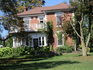
In 1821 William Howe bought lots 22 and 23 in the seventh concession of Erin township.  He built a general store and trading post on the 7th line.  His second, larger store, blew up due to careless smoking and storage of gunpowder. A third store was then built which operated into the 1970’s.  All of the old tin advertising for Coke, Black Cat Cigarettes and the Orange Crush door handle are all gone from the store front and now it survives as an office building.
IMG_0133

Nazareth Hill arrived a couple of years later and built a hotel on lot 25.  He surveyed his property for town lots and named the community after himself.  As Hillsburgh grew it swallowed Howville.  It was incorporated as a police village in 1899 with a population of 500.

The first school house dates to 1844 and survives today as a private residence.  A one room brick school was completed in 1864 with an addition for the juniors on the front in 1878. In 1960 six acres were purchased from the Nodwell farm and Ross R. McKay school was opened with four class rooms.  The picture below shows the old school which has served local farmers as Hillsburgh Feed since 1963.  The 1864 school room is hiding in the back beside the feed silos.

IMG_0015

William How is buried in the pioneer cemetery near the middle of town.  After many years of neglect the stones were gathered up and placed in a central location.

IMG_0018

William Nodwell came to Canada from Ireland in 1838 and settled on Lot 24.  His first log home burned down within a year.  Nodwell then sold half of the lot and constructed another log house and barns.  In 1868 the brick house shown below was built.  This view shows the front of the now abandoned house with it’s second story oriel window.  In 1895 the house at the corner of the lane was added for use by family members.  In 1926 Mungo Nodwell took over running the farm which was well known for the  potatoes he grew.  Today there is an open proposal to develop this farm for a subdivision and the electric fence that used to surround the school yard has been replaced with a row of trees.

IMG_0120

A second town hall was built in 1887.  The date stone is interesting because it has no “h” on the end of the town’s name.  Notice the two maple leaves above the date and the beaver below. The Beaver was the name of the town newspaper in 1887 and cost 25 cents per year, paid in advance.

IMG_0049

Six of Hillsburgh’s seven church buildings remain.  The first, and only missing, church was the Union Church and it stood beside the pioneer cemetery.  As each of the denominations grew they left the Union Church and got their own buildings.  From the south end of town is the Baptist Church (1862), Christian Church (1906) and St. Andrew’s Presbyterian (1869) which burned in 1965 and was rebuilt in the original walls.  Beside the river stands the United Church which was reassembled here in 1926 and the Anglican Church seen below.  It was built in the early 1890’s but closed in 1918 and served as a honey extracting plant after that.

IMG_0051

Hillsburgh didn’t have a fire hall until the church fire of 1965.  After that it had a two door building that stood beside the river.  When the arena was replaced it was moved to Station Road.  Today there is a semi-circle of concrete on the ground behind the arena to mark the tower where the fire hoses were hung to dry.

IMG_0056

The Exchange Hotel was built in 1883 and was one of three hotel buildings that remain in town. Until recently It had stables in the back for the traveler’s horses and lettering on the arch which said “Good Stabling”.  It is the only three story building in Hillsburgh.

IMG_0078

Church Street was home to the Methodist Church.  This was also the site of the town’s third cemetery which lies below the lawn.

IMG_0089

The Barbour house, dated 1889, is on Orangeville Street and is one of half a dozen houses in town which are dated in the 1880’s and 90’s on a diamond shape date stone.  These were built by Alexander Hyndman whose own 1879 house stands beside the Christian Church.

IMG_0128

On the south east corner of the 8th line and 27th side road lies one of the headwaters of the Credit River.  In 1906 this property belonged to the Caledon Trout Club and later was a fish hatchery.  From here the water flows through Hillsburgh’s three existing ponds and into the Credit River.  A little boat dropped in this trickle of water could eventually emerge in Lake Ontario at Port Credit beside the much larger ship The Ridgetown.

IMG_0127

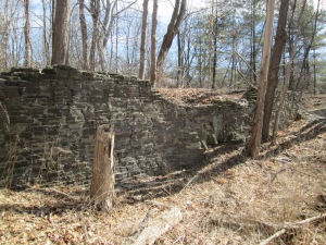
Leaving town on the 7th line there are two large hills.  In the hollow on lot 18 stood an old shack covered with asphalt siding.  During the early 1970’s a hermit lived in this house.  It was already in a state of decay at that time and collapsed by the middle of the decade.  Today one wall remains leaning against a tree and the rest is in advanced decay on the ground.  In good hermit fashion the property is strewn with old tin cans and empty bottles.

IMG_0137

An old car from the 1940’s or early 1950’s lies rusting in the tall grass at the back of Hermit Hollow.

IMG_0150

Hillsburgh retains many historical buildings and is an interesting time capsule of rural Ontario.

Like us at http://www.facebook.com/hikingthegta

Silverthorne Grist Mill – Meadowvale

Saturday March 28, 2015

(Revised March 31st)

It was minus 10 with a wind chill of minus 18.  This was one of the coldest morning hikes of the year, in spite of the date on the calendar.  We parked in the Meadowvale Conservation Area parking lot where the Second Line dead ends south of the new Derry Road.  We crossed under the bridge and walked north where the Meadowvale mill pond once connected with the river.

When John Beatty arrived in 1819 he brought the first settlers to the area.  He built mills along the Credit River and founded Meadowvale.  In 1831 Beatty sold his mills to James Crawford who opened saw and carding mills to compete with John Simpson who operated mills on lot 10 south of  Derry Road.  By 1836 Meadowvale had reached village status.  In 1844 Francis Silverthorne took over from Crawford and greatly expanded the mill complex building a saw mill.  In 1845 he added a large grist mill.  When it burned in 1853 he got backing from the Bank of Upper Canada and rebuilt.  During the Crimean War the price of flour had jumped from $1.50 per barrel to $3.00.  Silverthorne stockpiled grain in an effort to take advantage but when the war ended in 1860 the price fell to $1.00 per barrel.  When the Bank of Upper Canada foreclosed on his loan, William Gooderham, who was in charge of the bank, bought the property.  Gooderham and Worts had also purchased Alpha Mills, north of Streetsville, the same year.  Silverthorne retired to the family mansion, Cherry Hill.

After the Gooderhams the mill was owned by the Wheelers until 1895 when it was sold to Henry Brown.  Henry restored the mill and returned it to full production.  In 1906 he set about developing Meadowvale into a tourist attraction.  The first step was to increase the size of the mill pond and create what came to be known as Willow Lake.  He built a larger dam further north on the Credit to allow more water to be retained.  By following the western wall of the former Willow Lake we were able to locate the remnants of this dam.  Concrete remains can be found on both sides of the Credit River.

IMG_3079

Water is held in the western most parts of the old Willow Lake as we made our way along the berm toward the old mill.  The land along the western side of the old lake has been scooped out to create a retaining wall for the mill pond.

IMG_3077


After publishing this post I came across the following picture in the heritage assessment of 2014.  It shows an aerial view of Meadowvale with the old mill pond drawn in with dark blue and previous courses of the river in light blue.  Derry Road runs across the lower right corner and second line across the upper right corner.  Silerthorne’s grist mill is sketched in where the mill pond approaches Derry Road then follows along it in dark blue as the tail race.  His saw mill is drawn in a little above there where an old tail race returns to the river.

IMG_0101

As you approach old Derry Road concrete structures from the mill come into view.

IMG_3068

The mill stretched over both sides of the millway with the water wheel, and later the turbine, generating power to turn the grinding wheels to produce flour.

IMG_3030

The foundations on the west side of the millrace are pictured below.  Notice the stonework in the middle at ground level that marks a former water tunnel through the wall.

IMG_3137

This picture shows the main foundations for the water wheel.  Notice the bridge in the background where the tail race leads out along Willow Lane on it’s way back to the Credit River.

IMG_3064

The mill changed hands several times until it went out of production in 1950.  The Emersons owned the mill at the time and kept it for storage.  Fire is a common fate for grist mills and the community became concerned about its safety.  The wood was 100 years old, dry and full of a century of flour dust.  When Luther Emmerson was told he had to demolish it he did so himself.  Smashing it up in a fury and leaving the pieces where they fell.  The wood was carried away and the rest settled and was filled in.  They say the old turbines are still buried in the basement.

The mill stone has been preserved on the site of the Silverthorne Mill.  Mill stones come in pairs. The lower stone is stationary and is called the bedstone.  The upper stone, or runner, spins and does the actual grinding.  The grooves serve to channel the flour to the outside of the stones for collection.  The grain is fed through the eye in the centre of the runner stone to be ground between them.  Both upper and lower stones are preserved here.

IMG_2985

Willow Lane used to be known as Water Street and is home to some of the oldest houses in the village.  The house at 1125 Willow Lane is the oldest remaining building in town having been constructed in 1825 by John Beatty.  It later belonged to Crawford, Silverthorne and Gooderham as it seems to have changed hands with the ownership of the mills.

IMG_3058

By 1917 Guelph was linked to Toronto via the Toronto Suburban Railway line.  It ran from Lambton to Guelph, passing through Meadowvale.  The line ran from 1917 until it was shut down in 1931 when travel between Guelph and Toronto had switched to bus and car on highway 7.  The tail race from Silverthorne’s mill ran between Derry road and Willow Lane. The foundations of the old suburban railway line remain but are badly crumbling.

IMG_3041

The picture below shows the railway bridge over the tail race in 1915.  The past 100 years have taken their toll on the bridge.  The route of the train is even less easily distinguished as a flood control pond has been built on the old right of way south of Derry road.

Radial Railway Bridge, Meadowvale, c1915

Walking along the river back to the car you could hear the rustle of slush in the river as it rubbed along the river bank.  We weren’t the only ones hiking up the Credit River.

IMG_3024


By 1856 the mill was a major employer in the village and Silverthorne built cottages for his mill workers at 7077 and 7079 Pond Street.

IMG_3124

Charles Horace “Holly” Gooderham came to Meadowvale to run the mills on behalf of his father William Gooderham of Gooderham and Worts in Toronto.  In 1870 he commissioned a 21 room mansion that cost him $30,000.  The Gooderhams ran the mills, a cooperage and the general store in town.  When William Gooderham died in 1881 Holly left for Toronto and the estate was sold.  During the 1920’s it belonged to Samuel Curry whose brother, Walter, was a Member of the Legislative Assembly in Ontario from 1919-1923.  The house received several modifications over the years, including the oversized front portico and the white siding in the late 1970’s.

IMG_3094

Meadowvale was the first community to be honoured with the designation “Heritage Conservation District“.  The original community survives, largely intact, complete with it’s narrow streets designed for horse and carriage.  There are many historic buildings in town which will form the basis of a companion post.


Alpha Mills

Saturday Mar. 21, 2015

Spring officially started last night at 6:45 local time.  This morning was cloudy and dull with a wind that made the two degrees feel more like minus six.  A winter hang-over I guess.  We parked at the end of Alpha Mills Road where a walkway leads to the Credit River off Plainsman Road.

In 1825 Christopher Row(e) built a mill on lot 7 Concession IV where the river curves to the east, just north of Streetsville.   When J. Deady took over running the mill he renamed it Alpha Mills. It can be seen near the centre in the cover picture from the 1877 Peel County Atlas on property shown as belonging to Gooderham and Worts.  By 1877 there were 30 mills on the Credit River with 10 of them being textile related.  This was a localized industry that included the Barbertown Mills.

By the mid 1850’s Gooderham and Worts (G&W) had become the largest distillery in Canada and today their downtown manufacturing empire is preserved as 40 heritage buildings.  It is the largest collection of Victorian era industrial architecture in North America.  G&W began adding other mills to their holdings including Norval in 1845 and Hillsburgh in 1850.  In 1860 they acquired Alpha Mills and branded it as Alpha Knitting Mills.  G&W operated the mill until around the turn of the 20th century. William Gooderham’s grandson Albert would go on to purchase and gift a piece of property for Connaught Labs to the University of Toronto in 1917.  The 1971 aerial photo below shows the mill pond as the flat black area in the upper right corner.  The mill dam and water fall stretch across the river with the Alpha Knitting Mill building standing to the left just beside the dam.

Alpha

Not long after the photo above was taken the buildings and dam were removed and one of the most detailed diversion weirs I’ve ever seen was built in it’s place.  Storm water flows out of a buried channel and into these eight slots.  The concrete is curved upward to prevent things from washing over the edge and choking the system below, in this case it is this winter’s ice sheets.  The curve of the concrete gives the optical illusion that the water is flowing up hill.

IMG_2861

From the bottom of the storm drain looking back up there are 8 rows of concrete pillars with half-round steps in between.  For most of the length they are divided down the middle by a concrete wall.

IMG_2930

The long cold stretch of below freezing weather throughout February of this year froze the Credit River to a depth of up to two feet,  When the snow finally started to melt, the water level in the river increased under the ice, snapping it into large sheets which then washed up on the shore.  In the picture below they are stacked up four high.

IMG_2902

As we walked north up the west side of the river we crossed large chucks of river ice.  The piece of wood in the picture below has been trimmed clean by the local beaver.  It is rounded at both ends and all the bark removed.  Rather than construction material, this has been a food source for an example of Canada’s largest rodent. Once on shore, the river ice tends to melt in one of two ways.  The example in the picture below shows a slab of ice cut through by hundreds of small holes.

IMG_2905

In other places the ice is full of thousands of fine cracks that cause it to shatter into little shards. Either way, the ice is melted much faster than if it just melted along the exposed surfaces.

IMG_2904

I don’t usually post pictures of dead animals, although we see all kinds of them, but this Kestrel was wedged upside down in a pine tree.  There was no obvious cause of death and it appeared to have happened very recently.  Quite possibly it flew into the tree in the dark and broke it’s neck although this kind of accident must be quite rare.  It is considered rare, but birds do suffer heart disease, making this another possible explanation.  Or this kestrel might simply have been doing it’s impersonation of Kessel.

???????????????????????????????

Having made our way to Creditview road we crossed on the bridge and started back up the other side. While walking along the river at this time of year it is important not to walk on any shelf of ice that might be close to the river edge.  I suspect that, had we stepped on this shelf when we passed, we wouldn’t have enjoyed the water quite as much as the two ducks in the picture below.  Like these ducks, it was obvious that the bird kingdom has started to count itself off into breeding pairs.  Cardinals, Buffleheads and Canada Geese were also seen to be paired up.

IMG_2908

There is only a short stretch of the east river bank that is safely passable at this time of the year. The bank of the river on this side is full of new growth and bramble.  At one time several of the homes on top of the ravine had built wooden or concrete stairs to access the river side.  The tree that has taken out this abandoned set of stairs looked like fair warning and so we returned to Creditview Road.  Sir Monty Drive provides a short cut back to the park without having to walk too far on roads.

IMG_2909

The park on the east side of the river is accessed from Sir Monty Drive and has a maintained trail on it.  This part of the river is known as River Run Park.  Large clusters of teasels grow along the trail.

IMG_2916

Someone has taken the time to cover this old well with a roof but the current dwelling is at the top of the ravine.  Perhaps an earlier home stood closer to this water source making the task of bringing water to the hill top unnecessary.

IMG_2917

Visit us at http://www.facebook.com/hikingthegta for a gallery of additional photos.